Mori Atlas logo
National parkOnon-Balj National Park

Discover the unique geography and mapped boundaries of a key transition zone landscape.

Onon-Balj National Park: Protected River Valley in Khentii Province, Mongolia

(Онон Балжийн байгалийн цогцолборт газар)

Onon-Balj National Park represents a significant protected landscape in Mongolia's Khentii Province, safeguarding the vital river valley system of the Onon and Balj rivers. Situated in a crucial ecological transition zone between Siberian coniferous forests and the Daurian steppe, this national park offers a unique vantage point for exploring varied terrains, from forested slopes to riparian habitats. Its geographic context and protected status make it a key destination for understanding regional biodiversity and landscape patterns.

River ValleyBiodiversity HotspotImportant Bird AreaTransition ZoneProtected ForestMountain Landscape

Onon-Balj National Park

National park

Park overview

Structured park overview, official facts, and landscape profile for Onon-Balj National Park

Onon-Balj National Park park facts, protected area profile, and essential visitor context

Review the core facts for Onon-Balj National Park, including designation, size, terrain, visitor scale, habitats, and operating context in one park-focused overview.

About Onon-Balj National Park

Onon-Balj National Park occupies a distinctive position in Mongolia's protected area network as a guardian of the Onon River valley system in the country's far northeast. The park's location in Khentii Province places it at the edge of Mongolia's forested northern territories, where the landscape transitions from the boreal character of the Trans-Baikal region into the open steppe environments that dominate much of the country. This ecological boundary zone produces a mosaic of habitats that supports relatively high biodiversity compared to more uniform landscapes elsewhere in Mongolia. The Onon River, which gives the park its name, originates in Mongolia and flows northward into Russia, eventually joining the Amur River system. Along its passage through the park, the river is flanked by willow groves, floodplain forests, and riparian corridors that contrast sharply with the surrounding mountainous terrain. The park's protection of these river corridors is particularly significant given the broader context of Mongolia's semi-arid environment, where permanent water sources and their associated ecosystems are limited and ecologically crucial. The establishment of the park in 2000 reflected Mongolia's growing commitment to conserving its northern forest and steppe transition zones, which had previously received limited formal protection despite their ecological and cultural importance.

Quick facts and research context for Onon-Balj National Park

Onon-Balj National Park spans 4,158 square kilometers in northeastern Mongolia's Khentii Province, protecting the Onon and Balj River valleys at elevations ranging from 840 to 1,568 meters. The terrain consists of rounded mid-sized mountains with gentle slopes, centered around the confluence of these two rivers. The park lies in a cold semi-arid climate zone and forms the southern edge of the Trans-Baikal conifer forests ecoregion. Established in 2000 under the management of Mongolia's Ministry of Environment and Green Development, the area is recognized as an Important Bird Area by BirdLife International.

Protection and recognition

Analyzing terrestrial conservation limits and documented UNESCO biosphere status

Onon-Balj National Park Protection Status and International Designation

Active terrestrial management frameworks define the geographic boundaries and official conservation status of Onon-Balj National Park. Documented credentials include designation as a UNESCO Biosphere Reserve, establishing a structured baseline for regional environmental mapping and global protected-area research.

International recognition

Protection details

Protection scope
Terrestrial
Designated year
2023
Core area
345.81 km²
Buffer area
3,909.36 km²
Park context

Deeper park guide and search-rich context for Onon-Balj National Park

Onon-Balj National Park history, landscape, wildlife, and travel context

Explore Onon-Balj National Park through its history, landscape character, ecosystems, wildlife, conservation priorities, cultural context, and seasonal travel timing in a structured park guide built for atlas discovery and search intent.

Why Onon-Balj National Park stands out

Onon-Balj National Park is best known for its position at the ecological crossroads between Siberian coniferous forests and the Mongolian Daurian steppe, creating a biologically diverse transition zone. The park protects critical riparian habitat along the Onon River, one of Mongolia's major northern rivers that flows into Russia. It is also renowned for its population of vulnerable bird species including the Swan Goose and White-naped Crane, and for its cultural association with the ancestral lands of Genghis Khan in Khentii Province, traditionally considered the birthplace of the Mongol Empire.
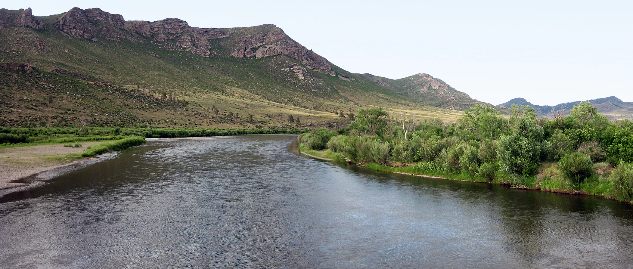
River flowing through a valley surrounded by green vegetation and distant mountains
Panoramic view of the Onon River flowing through a valley with mountains in the background

Onon-Balj National Park history and protected-area timeline

Onon-Balj National Park was established in 2000 as part of Mongolia's expansion of its national park system during the late 1990s and early 2000s. The park was created to protect the significant natural and cultural values of the Onon River valley in Khentii Province, a region that had long been recognized for both its ecological diversity and its historical importance. The governing body for the park is the Ministry of Environment and Green Development of Mongolia, which oversees management and protection activities. The selection of this area for national park status reflected growing understanding of the region's biodiversity significance, particularly its role as a transition zone supporting species from both northern and southern ecological communities. The park also preserves landscape associated with the historical legacy of Genghis Khan, as Khentii Province is traditionally considered the birthplace and heartland of the Mongol Empire.

Onon-Balj National Park landscape and geographic character

The physical landscape of Onon-Balj National Park centers on the valley system formed by the Onon and Balj Rivers, which meet within the park boundaries. The surrounding terrain consists of mid-sized mountains with generally rounded tops and mild slopes, creating a landscape of moderate relief rather than dramatic alpine peaks. Elevations within the park range from approximately 840 meters along the Onon River valley floor to 1,568 meters at Kentsuu Mountain, providing significant altitudinal variation that contributes to habitat diversity. The river valleys themselves contain floodplain areas, willow groves, and riparian forests that contrast with the drier slopes and upland terrain. This combination of river corridors, forested valley bottoms, and open mountain slopes creates a visually diverse landscape that reflects the park's position at the boundary between different environmental zones.

Onon-Balj National Park ecosystems, habitats, and plant life

The ecological character of Onon-Balj National Park is defined by its position in a transition zone between major biomes. The park lies at the southern extent of the Trans-Baikal conifer forests ecoregion, bringing elements of Siberian boreal forest into Mongolia. Vegetation within the park varies significantly based on position within the landscape and altitude. Along the river courses, willow groves and riparian forests dominate, with floodplain vegetation adapted to the seasonal dynamics of river flow. On the mountain slopes and upland areas, the vegetation transitions from forest steppe through to steppe communities as elevation and distance from water sources increases. The forests are characterized by pine and larch trees, representing the southernmost extensions of these boreal species into Mongolia. This varied vegetation creates a mosaic of habitats that supports diverse ecological communities.

Onon-Balj National Park wildlife and species highlights

Onon-Balj National Park supports notable wildlife populations, with particular significance attached to its bird communities. The park has been designated an Important Bird Area by BirdLife International, recognizing its importance for breeding bird populations. Three species of particular conservation concern breed within the park: the Swan Goose, classified as vulnerable, the White-naped Crane, also vulnerable, and the Lesser kestrel. These species depend on the wetland and grassland habitats found within the river valley system. Mammal populations include the Daurian ground squirrel, a characteristic species of the steppe and forest steppe zones, and the Raccoon dog, an unusual canid species present in the region's forested habitats. The park's position at the transition between different habitat types supports this diversity of species, with northern forest species and southern steppe species both finding suitable conditions within its boundaries.

Onon-Balj National Park conservation status and protection priorities

Onon-Balj National Park serves important conservation functions in the context of Mongolia's protected area network. The park protects a representative sample of the Trans-Baikal conifer forest ecoregion at its southern limit, preserving this transitional ecosystem for future generations. The riparian forest and wetland habitats along the Onon River are particularly valuable, supporting vulnerable bird species and providing ecological services within the broader semi-arid landscape. The park's designation as an Important Bird Area by BirdLife International reflects international recognition of its significance for conservation. However, the park faces ongoing conservation challenges, with forest fires representing a significant threat to habitat integrity. Management efforts focus on fire prevention and response, as well as general protection of the park's natural values.

Onon-Balj National Park cultural meaning and human context

Onon-Balj National Park is situated in Khentii Province, a region of profound historical and cultural significance in Mongolia. This province is traditionally associated with the origins of the Mongol Empire and is considered the ancestral homeland of Genghis Khan. The Onon River valley falls within the broader landscape that oral and written traditions link to the early life of Genghis Khan and the unification of Mongol tribes. While the park's primary designation is for nature conservation, this cultural dimension adds interpretive depth to the protected area, connecting the ecological significance of the river valleys to the historical narratives of Mongolia's founding. The park's distance from major population centers, approximately 280 kilometers from Ulaanbaatar, has helped preserve both its natural character and its association with this historic landscape.

Top sights and standout views in Onon-Balj National Park

Onon-Balj National Park offers distinctive natural and cultural experiences rooted in its unique geographic position. The park provides opportunities to explore a river valley system at the ecological boundary between Siberian forest and Mongolian steppe, a transition zone that produces diverse landscapes within a relatively compact area. The Onon River itself is a major watercourse that flows northward into Russia, and the park protects significant stretches of this river and its associated riparian habitats. Wildlife viewing opportunities focus particularly on the park's bird populations, including vulnerable species like the Swan Goose and White-naped Crane that breed in the river valley wetlands. The park's association with Genghis Khan's homeland adds a cultural dimension that distinguishes it from purely ecological protected areas.

Best time to visit Onon-Balj National Park

The most favorable time to visit Onon-Balj National Park coincides with the warmer months from May through September, when temperatures are moderate and access to the park is most practical. Summer months offer the warmest conditions and peak vegetation, with the river valleys displaying their full green character and wildlife activity at its highest levels. Early autumn in September can also be rewarding, as the changing season brings different colors to the forested slopes while maintaining comfortable访问 conditions. Winter visits are challenging due to cold temperatures and reduced access, while spring conditions can be variable with snowmelt affecting river crossings. The park's remote location in northeastern Mongolia means that travel planning should account for the distance from Ulaanbaatar and the limited infrastructure in the surrounding region.
Monthly climate preview

Analyze annual temperature fluctuations and monthly precipitation patterns across Khentii Province

Long Term Climate Normals and Weather by Month for Onon-Balj National Park

NASA climatology data at a representative elevation of 1149 meters reveals extreme winter freezes alongside warm summer averages in Onon-Balj National Park. Accessing the complete twelve month profile provides detailed daily precipitation averages and historical temperature ranges for deeper geographic comparison.
Annual mean0 °C
-20 °C19 °C
Jan-20°
Feb-16°
Mar-7°
Apr
May10°
Jun17°
Jul19°
Aug17°
Sep
Oct
Nov-10°
Dec-17°
Warmest month
July

19.1 °C

Coolest month
January

-19.6 °C

Wettest month
July

2.8 mm/day

Driest month
January

0.1 mm/day

Park location guide

Geography guide, regional context, and park location map for Onon-Balj National Park

Onon-Balj National Park park geography, regions, and map view in Mongolia

Understand where Onon-Balj National Park sits in Mongolia through a broader geographic reading of the surrounding landscape, nearby location context, and its mapped position within the national park landscape.

How Onon-Balj National Park fits into Mongolia

Mongolia is a landlocked sovereign state in East Asia, known for its vast steppe landscapes, nomadic culture, and historical significance as the heartland of the Mongol Empire founded by Genghis Khan in 1206. The country has a population of approximately 3.5 million people and is the world's most sparsely populated sovereign state. Ulaanbaatar is the capital and largest city, home to roughly half the population.

Wider geography shaping Onon-Balj National Park in Mongolia

Mongolia is located in East Asia, landlocked between Russia to the north and China to the south. The country occupies the Mongolian Plateau and features diverse terrain including grassy steppe, mountains in the north and west, and the Gobi Desert in the south. It covers 1,564,116 km2, making it the second largest landlocked country in the world.

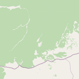
Map view of Onon-Balj National Park

Use this park location map to pinpoint Onon-Balj National Park in Mongolia, understand its exact geographic position, and read its mapped placement within the surrounding landscape more clearly.

Pigeon | © OpenStreetMap contributors

Location context for Onon-Balj National Park

Khentii Province

Trace the unique visual character of Onon-Balj's river corridors, forested valleys, and Daurian steppe habitats.

Onon-Balj National Park Photography: Explore Diverse Landscapes and Protected Area Scenery

Explore imagery capturing the varied landscapes of Onon-Balj National Park, from its significant river valleys and forested terrain to the expansive Daurian steppe environments. These visual resources deepen understanding of the park's protected-area character, illustrating its critical ecological transition zone between Siberian forests and Mongolian grasslands.

River flowing through a valley surrounded by green vegetation and distant mountains

Park atlas

Compare protected landscapes, river valleys, and transition zones across Mongolia's Khentii Province and its surrounding northern regions.

Explore Other National Parks and Protected Areas Near Onon-Balj National Park

After exploring Onon-Balj National Park's river valley and forest-steppe transition zone, browse other protected areas in Mongolia and its northern regions to compare diverse conservation landscapes. Trace regional park geography, riparian habitats, and mountain ecosystems to understand the broader spread of protected lands and their ecological significance.
Watercolor painting of a river winding through hills with trees and vegetation
National parkZabaykalsky Krai
About 105 km away#1 closest

Northwest

Chikoy National Park: Protected National Park with Highland Landscape and River Basin Geography

Explore its protected boundaries and unique taiga-steppe transition in Zabaykalsky Krai.

Chikoy National Park, a protected area in Russia's Zabaykalsky Krai, showcases the rugged geography of the Khentei-Daur Highlands. As a national park, it preserves the upper Chikoy River basin and represents a significant ecological borderland, marking the transition from Siberian taiga to Mongolian steppe. This page facilitates a structured understanding of the park's mapped landscape, its prominent natural monument Bystrinsky Golets, and its role within the broader atlas of protected natural areas.

Area
6,665 km²
Established
2014
IUCN
II
Relief
Mountain
Wildlife reserveKhentii Province
About 184 km away#2 closest

West

Khan Khentii Strictly Protected Area: Geographic Overview and Protected Landscape Mapping

Eastern Mongolia wilderness and Khentii mountain terrain

Explore the expansive reaches of Khan Khentii Strictly Protected Area, a cornerstone of Mongolian conservation. This reserve shields intact taiga forests, river valley habitats, and the historic Burkhan Khaldun mountain from industrial activity, preserving one of the most significant mountain wilderness regions in the province of Khentii.

Area
12,270 km²
Established
1992
IUCN
Ib
Relief
Mountain
Watercolor illustration depicting layered mountains, green hills, and forested areas with purple and pink tones
National parkZabaykalsky Krai
About 265 km away#3 closest

Northeast

Alkhanay National Park: A Study of Sacred Peaks and Daurian Forest Steppe Geography

Protected mountain landscapes in Russia's Zabaykalsky Krai

Alkhanay National Park preserves a unique transitional landscape where rugged mountain terrain meets the expansive Siberian steppe. Focused on the sacred Mount Alkhanai, the area features dramatic rock landforms, pine-covered canyons, and mineral springs. This protected zone provides a deep look into the geological and ecological history of the Mogotuyskogo Range and surrounding border regions.

Area
1,382 km²
Established
1999
IUCN
II
Relief
Mountain
National parkZabaykalsky Krai
About 265 km away#4 closest

Northeast

Alkhanay National Park: Protected Mountain Terrain and Volcanic Landscapes of Zabaykalsky Krai

Mapping Siberia's forest-steppe transition and sacred mountain geography

Alkhanay National Park preserves an unusual assembly of Siberian mountain taiga, volcanic geology, and Buddhist heritage sites within the Zabaykalsky Krai region. The protected territory spans mid-elevation ranges and river valleys, offering deep insights into the intersection of ecological watershed protection and spiritual land preservation in the Russian Far East.

Area
1,382.34 km²
Established
1999
IUCN
II
Visitors
30K annual
National parkTöv Province
About 276 km away#5 closest

West

Gorkhi-Terelj National Park: Mapped Protected Landscape in Töv Province

Explore the geographic context and park boundaries.

Gorkhi-Terelj National Park is a designated national park offering rich opportunities for geographic exploration and protected landscape discovery. This entity page provides detailed insights into its mapped boundaries and its position within the regional geography of Töv Province. Understand the specific landform and terrain characteristics that define this protected natural area, central to understanding Mongolia's conservation landscapes.

Area
2,920 km²
Established
1993
IUCN
II
Relief
Mountain
Nature reserveDornod Province
About 301 km away#6 closest

East

Mongol Daguur Nature Reserve: Steppe and Wetland Geography in Eastern Mongolia

Protected landscape boundaries within Dornod Province

An authoritative overview of the Mongol Daguur protected area, focusing on its role as a core element of the Daurian landscape. Discover the spatial distribution of its steppe habitats, wetland systems, and mountain-grassland terrain that define this eastern Mongolian region.

Area
156 km²
Established
1998
IUCN
Ib
Relief
Lowland
Biosphere reserveUlaanbaatar
About 331 km away#7 closest

West

Bogd Khan Uul Biosphere Reserve: Mapped Protected Landscapes and Geographic Overview

Highland ecosystems and forest steppe in the Khentii Mountains.

Rising directly south of Ulaanbaatar, Bogd Khan Uul Biosphere Reserve protects a compact mosaic of habitats including larch forests, Siberian pine stands, and alpine rock. The reserve serves as a critical geographic marker, illustrating the rapid shift from urban fringes to subalpine wilderness while maintaining a history of sacred environmental protection that informs its current status as a biosphere reserve.

Area
673 km²
Established
1996
Relief
Mountain
Climate
Boreal
National parkTöv Province
About 391 km away#8 closest

West

Hustai National Park: Geographic and Protected Landscape Profile in Töv Province

Steppe, mountain, and riverine ecosystem mapping

Hustai National Park serves as a landmark conservation site in Töv Province, protecting a distinct gradient between the Khustai mountain ridges and the surrounding Mongolian plains. The area is defined by its role in steppe ecology, featuring varied slopes, riverine woodlands, and expansive grasslands that support a unique assembly of wildlife within the broader central Mongolian region.

Area
506 km²
Established
2003
IUCN
II
Relief
Mountain

Common questions about visiting, size, designation, and location context for Onon-Balj National Park

Onon-Balj National Park FAQs for park facts, access, geography, and protected area context

Find quick answers about Onon-Balj National Park, including protected-area facts, park geography, trail and visitor context, and how the park fits into its surrounding country and regional landscape.
MoriAtlas Explorer

Continue Your Protected Areas Search Across the Global Atlas

Deepen your exploration by continuing the structured search for national parks and protected areas worldwide. Utilize the comprehensive filtering capabilities to compare different conservation landscapes and refine your understanding of global park geography. Discover more about the distribution and characteristics of protected natural areas.

Global natural geography