Mori Atlas logo
National parkTunkinsky National Park

Mapping the protected boundaries and natural terrain within this significant Russian national park.

Tunkinsky National Park: National Park Protected Landscape and Regional Geography in Buryatia

Tunkinsky National Park represents a key protected natural landscape within the Republic of Buryatia, Russia. This page offers an atlas-oriented view, focusing on the park's mapped boundaries and its integral role within the broader regional geography. Understand the park's context as a designated national park, providing a foundation for exploring its unique natural features and their placement within the Siberian landscape.

Siberian wildernessSayan MountainsAlpine landscapesTaiga forestsBiodiversity hotspotHot springs

Tunkinsky National Park

National park

Park overview

Structured park overview, official facts, and landscape profile for Tunkinsky National Park

Tunkinsky National Park park facts, protected area profile, and essential visitor context
Review the core facts for Tunkinsky National Park, including designation, size, terrain, visitor scale, habitats, and operating context in one park-focused overview.

About Tunkinsky National Park

Tunkinsky National Park represents one of Siberia's most ecologically significant protected areas, spanning approximately 1.18 million hectares in the Republic of Buryatia. The park occupies the entire Tunkinsky District, creating a comprehensive protected zone that encompasses the Irkut River valley and surrounding mountain systems. This mountainous region forms a natural corridor between Lake Baikal, the world's deepest freshwater lake, and Lake Khövsgöl in Mongolia. The landscape is characterized by the Tunka Alps, a spectacular mountain range featuring dramatic glacial and rift valleys, cascading waterfalls, and mineral hot springs that have drawn visitors for centuries. The central valley around the Irkut River contains fertile agricultural land and small settlements where the indigenous Buryat people maintain traditional ways of life. The park's ecological significance is amplified by its position at a biological crossroads, where Siberian taiga forests meet Mongolian steppe and alpine tundra zones, creating unusual diversity within a single protected area.

Quick facts and research context for Tunkinsky National Park

Tunkinsky National Park covers approximately 1,183,662 hectares in the Tunkinsky District of Buryatia, Russia. The park is located about 200 kilometres southwest of Irkutsk and sits between two of Siberia's great lakes: Lake Baikal to the northeast and Lake Khövsgöl in Mongolia to the southwest. The park occupies the entire Tunkinsky District, with its boundaries coterminous with the district. The Irkut River flows through the central valley, which has fertile soil supporting agriculture and small settlements inhabited by the indigenous Buryat people. The park's elevation range spans from 668 metres in the valley floor to 3,172 metres in the surrounding mountains.

Park context

Deeper park guide and search-rich context for Tunkinsky National Park

Tunkinsky National Park history, landscape, wildlife, and travel context
Explore Tunkinsky National Park through its history, landscape character, ecosystems, wildlife, conservation priorities, cultural context, and seasonal travel timing in a structured park guide built for atlas discovery and search intent.

Why Tunkinsky National Park stands out

Tunkinsky National Park is best known for its dramatic alpine landscapes at the eastern edge of the Sayan Mountains, where rift and glacial valleys create spectacular scenery. The park is renowned for its hot springs and mineral spas, particularly at the resort town of Arshan. It is also significant as a biodiversity hotspot, serving as a habitat for snow leopards at the northern edge of their range, as well as Asiatic wild dogs (dholes). The park's position at the intersection of taiga, steppe, alpine forest, and lake ecosystems creates remarkable ecological diversity across a relatively compact area.

Wide landscape view of a mountainous region with forested hills, grassy plains in the foreground, and snow-capped mountains in the background under a clear sky
Mountainous landscape in Tunkinsky National Park with forested hills and snow-capped mountains in the background

Tunkinsky National Park history and protected-area timeline

Tunkinsky National Park was established as a protected area in 1991, designated under Russian federal law as a nature reserve of special significance. The park's creation reflected growing recognition of the region's ecological importance and the need to protect its unique combination of habitats, species, and landscapes. Prior to formal protection, the Tunkinsky District had long served as a traditional homeland for the Buryat people, an indigenous Mongolian-speaking group with deep cultural ties to the landscape. The establishment of the park coincided with broader environmental protection efforts in post-Soviet Russia and the development of sustainable tourism infrastructure in the region, particularly around the mineral springs of Arshan. The park's boundaries were designed to encompass the entire district, ensuring comprehensive protection of the valley and surrounding ecosystems.

Tunkinsky National Park landscape and geographic character

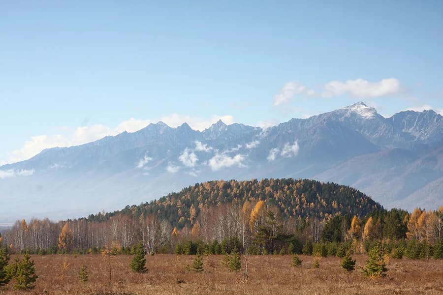
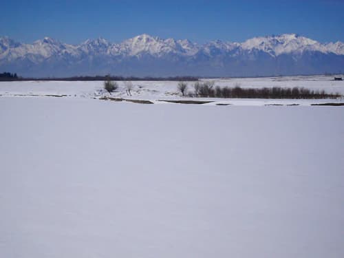
The physical landscape of Tunkinsky National Park is defined by its position at the eastern edge of the Sayan Mountains, where the massive mountain system meets the valleys leading toward Mongolia. The park features the Tunka Alps, a spectacular range of peaks reaching 3,172 metres, carved by ancient glacial activity into dramatic ridges, cirques, and U-shaped valleys. The Irkut River flows through a broad central valley with fertile soils, surrounded by forested mountain slopes that rise sharply to the north and west. Extinct volcanoes, such as the Talskaya volcano, punctuate the landscape, adding geological significance. The terrain encompasses rift valleys, glacial valleys, hot springs, alpine meadows, and forested slopes, creating a visually diverse and geologically complex environment. The contrast between the flat, productive valley floor and the rugged mountain backdrop defines the park's distinctive character.

Snow-covered field with the Irkut River and distant snow-capped mountains under a clear blue sky
Snow-covered landscape of the Irkut River valley with distant snow-capped mountains under a clear blue sky

Tunkinsky National Park ecosystems, habitats, and plant life

The ecological character of Tunkinsky National Park is defined by its position at the intersection of multiple distinct biomes, creating remarkable habitat diversity within a single protected area. The mid-elevation mountain slopes support Sayan montane conifer forests, a transitional forest type containing species from both the Siberian taiga and the Mongolian steppe, primarily pine, cedar, and larch. The lower valley regions transition into forest-steppe vegetation, while higher elevations feature tundra and alpine glades. This ecological gradient supports exceptional plant diversity, with over 900 vascular plant species recorded and 43 endemic species listed in the Russian Red Book as endangered. The park's location between two of Siberia's great lakes and its variety of habitats create a unique ecological bridge across continental Asia.

Tunkinsky National Park wildlife and species highlights

Tunkinsky National Park supports exceptional wildlife diversity, with over 305 vertebrate species recorded within its boundaries. Of these, 62 species are classified as rare or endangered, making the park particularly significant for conservation. The park provides confirmed habitat for snow leopards at the northern edge of their global range, representing one of the northernmost populations of this endangered big cat. The Asiatic wild dog, or dhole, also reaches its northern range limit within the park. Mammal species include Siberian roe deer, wolverine, elk, and steppe polecat. The avifauna is particularly rich, with 207 nesting bird species and an additional 30 transitory species recorded. Fish populations include grayling, carp, dace, and roach, while the park also supports four amphibian and five reptile species.

Tunkinsky National Park conservation status and protection priorities

Tunkinsky National Park holds significant conservation importance as a protected area encompassing multiple threatened ecosystems and species at the edge of their geographic ranges. The park provides critical habitat for snow leopards and dholes, both species of conservation concern that reach their northern range limits in this region. Its designation as a Category II protected area under IUCN guidelines reflects its national park status and the formal protection it provides to Siberia's unique transitional ecosystems. The preservation of the Sayan montane conifer forests, forest-steppe, and alpine tundra habitats within a single protected unit helps maintain ecological connectivity across a biologically diverse landscape. The presence of 43 endemic plant species in the Russian Red Book further underscores the park's conservation significance for botanical heritage.

Tunkinsky National Park cultural meaning and human context

Tunkinsky National Park contains the traditional homeland of the Siberian Buryat people, an indigenous Mongolian-speaking community with deep historical roots in the Tunkinsky Valley. The valley has been inhabited for centuries, with Buryat settlements maintaining traditional agricultural practices and cultural traditions. The town of Arshan within the park is known for its carbonate mineral springs, which have been used for therapeutic purposes for generations, creating a cultural tradition of spa and wellness practices that continues today. The Buddhist Datsan temple near Arshan represents the spiritual heritage of the Buryat community, adding religious and architectural significance to the cultural landscape. This human dimension coexists with the natural environment, creating a landscape where cultural and ecological preservation are intertwined.

Top sights and standout views in Tunkinsky National Park

The highlights of Tunkinsky National Park include the spectacular alpine scenery of the Tunka Alps with their glacial valleys and dramatic peaks, the therapeutic mineral springs of Arshan spa town, and the opportunity to observe snow leopards in their northernmost habitat. The park offers diverse outdoor activities including backpacking through pristine taiga forests, kayaking on the Irkut River, mountaineering on volcanic peaks, and rock climbing on alpine cliffs. The ecological diversity created by the meeting point of taiga, steppe, and alpine habitats provides exceptional biodiversity viewing opportunities, while the cultural heritage of the Buryat people adds historical depth to the wilderness experience.

Best time to visit Tunkinsky National Park

The best time to visit Tunkinsky National Park depends on the desired experience, with the summer months of June through August offering the warmest conditions and maximum accessibility for hiking and outdoor activities. Summer brings the warmest temperatures to the valley and alpine zones, with precipitation maximum occurring during this season, creating lush meadow environments and active waterfalls. The subarctic climate means winters are cold and snowy, with temperatures dropping significantly in the mountain areas. The shoulder seasons of spring and autumn provide different characteristics, with spring bringing snowmelt and new growth while autumn offers fall colours in the larch and pine forests. For wildlife viewing, the summer months coincide with greater animal activity, while winter provides opportunities to observe species adapted to snowy conditions.

Park location guide

Geography guide, regional context, and park location map for Tunkinsky National Park

Tunkinsky National Park park geography, regions, and map view in Russia
Understand where Tunkinsky National Park sits in Russia through a broader geographic reading of the surrounding landscape, nearby location context, and its mapped position within the national park landscape.

How Tunkinsky National Park fits into Russia

Russia is a transcontinental nation spanning eleven time zones, bordered by fourteen countries. It is the world's largest country by area, covering 17,098,246 km². Moscow is the capital and largest city, while Saint Petersburg is the second-largest and a major cultural centre.

Wider geography shaping Tunkinsky National Park in Russia

Russia spans Eastern Europe and North Asia, covering 17,098,246 km². It shares land borders with fourteen countries, more than any other nation, and spans eleven time zones. The landscape includes vast plains, mountain ranges such as the Urals and Caucasus, and extensive coastlines along the Arctic Ocean, Pacific Ocean, Baltic Sea, Black Sea, and Caspian Sea.

Map view of Tunkinsky National Park

Use this park location map to pinpoint Tunkinsky National Park in Russia, understand its exact geographic position, and read its mapped placement within the surrounding landscape more clearly.

Pigeon | © OpenStreetMap contributors

Location context for Tunkinsky National Park

Buryatia

Visual reference of Tunkinsky's dramatic Sayan Mountain landscapes, glacial valleys, and taiga habitats

Tunkinsky National Park Photos: Visual Guide to Siberian Alpine Landscapes and Wilderness Scenery
Immerse yourself in the visual identity of Tunkinsky National Park through detailed imagery showcasing its rugged alpine terrain, expansive taiga forests, and pristine river valleys. Understanding the unique geographic features and distinct ecological zones, from high mountain peaks to biodiverse river ecosystems, provides a deeper appreciation of this Siberian protected area.

Wide landscape view of a mountainous region with forested hills, grassy plains in the foreground, and snow-capped mountains in the background under a clear sky

Golden lion statue adorned with blue scarves, set against a backdrop of distant mountains and a road under a clear blue sky

Snow-covered field with the Irkut River and distant snow-capped mountains under a clear blue sky

Park atlas

Expand your view from Tunkinsky's unique landscapes to trace other protected areas across southern Siberia and the Sayan Mountains

Discover Related National Parks and Protected Areas Near Tunkinsky National Park in Siberia
Explore additional national parks and protected areas across the Siberian wilderness, encompassing diverse alpine landscapes, taiga forests, and steppe environments near Tunkinsky National Park. This view supports geographic comparison, enabling a deeper understanding of regional protected-area patterns and connected conservation efforts across Siberia.
Watercolor illustration showing a lake, green vegetation, and mountains under a light sky
National parkIrkutsk Oblast

Pribaikalsky National Park: A Protected Siberian Landscape on Lake Baikal's Shores

Explore mapped boundaries and regional geography.

Pribaikalsky National Park is a key protected area in Irkutsk Oblast, critical for conserving the biodiversity and unique topography of Lake Baikal. This national park encompasses dramatic mountain terrain, coastal landscapes, and the significant Olkhon Island, offering a detailed geographic study for atlas exploration. Discover the mapped extent of this important natural reserve and its role in preserving one of Earth's most exceptional freshwater ecosystems and its surrounding Siberian environment.

Area
4,173 km²
Established
1986
IUCN
II
Visitors
400K annual
National parkMongolia

Khorgo-Terkhiin Tsagaan Nuur National Park: Mongolian National Park Protected Landscape Atlas

Mapped geographic context and protected land identity in Mongolia.

Khorgo-Terkhiin Tsagaan Nuur National Park is a designated national park in Mongolia, offering a valuable component of the country's protected lands. This detailed entry focuses on its geographic position and mapped boundaries, providing essential context for understanding its unique landscape within the vast Mongolian plateau. Explore the protected area's distinct identity and its contribution to the regional natural geography, fostering a deeper appreciation for the mapped terrain.

Area
8 km²
Established
1965
IUCN
II
Relief
Mountain
National parkMongolia

Khogno Khan National Park: A National Park with Distinct Mongolian Landscape Identity

Explore its mapped terrain and regional geographic context.

Khogno Khan National Park is a designated national park offering a specific focus for protected landscape discovery. Users can explore its geographic placement within Mongolia and understand its role as a mapped natural area. The park's identity as a protected territory provides critical context for those interested in the atlas of East Asian landscapes and regional geography, highlighting a distinct area for geographic study.

Area
841 km²
Established
2003
IUCN
II
Relief
Mountain
National parkMongolia

Khangai Nuruu National Park: Discover Mongolia's Protected Mountain Landscape and Atlas Context

Explore mapped boundaries and diverse ecosystems across its terrain.

Khangai Nuruu National Park stands as a vast national park in central Mongolia, characterized by its diverse protected landscapes and significant geographic scope. Spanning the Khangai Mountains, it presents a remarkable ecological transition from alpine meadows and taiga forests to steppe and riparian environments. This park offers a rich atlas exploration opportunity, highlighting its mapped boundaries and the unique regional geography that defines its protected status, making it a key point of discovery for understanding Mongolian conservation areas.

Area
8,885 km²
Established
1996
IUCN
II
Relief
Mountain
National parkZavkhan Province

Tarvagatai Nuruu National Park: Zavkhan Province Protected Landscape Atlas

Unique steppe-to-forest transition and mountainous terrain.

Tarvagatai Nuruu National Park represents a critical protected area within Mongolia's Zavkhan Province, noted for its expansive mountainous terrain and significant ecological diversity. The park's landscape is defined by the Tarvagatai Range, featuring flat-topped ridges, glacial valleys, and dramatic elevation changes. It masterfully showcases the transition from semi-arid steppe to dense coniferous forests, highlighting a visually striking ecological boundary anchored by the prominence of Mount Otgontenger, the highest peak in the Khangai Mountains.

Area
5,467 km²
Established
2000
IUCN
II
Relief
Mountain
Watercolor painting depicting a lake with mountain ranges, green hills, and scattered trees.
National parkBuryatia

Zaybaykalsky National Park: National Park Atlas and Protected Landscape Explorer

Buryatia's Protected Area and Geographic Context

Uncover the geographic identity of Zaybaykalsky National Park, a designated national park within the Republic of Buryatia. This platform facilitates a structured exploration of its protected landscape, emphasizing its mapped boundaries and its place within the regional geography of Siberia. Understand the park's significance through a dedicated atlas lens, focusing on its inherent natural terrain and protected status, aiding in detailed geographic discovery.

Area
2,690 km²
Established
1986
IUCN
II
Relief
Mountain
National parkTöv Province

Gorkhi-Terelj National Park: Mapped Protected Landscape in Töv Province

Explore the geographic context and park boundaries.

Gorkhi-Terelj National Park is a designated national park offering rich opportunities for geographic exploration and protected landscape discovery. This entity page provides detailed insights into its mapped boundaries and its position within the regional geography of Töv Province. Understand the specific landform and terrain characteristics that define this protected natural area, central to understanding Mongolia's conservation landscapes.

Area
2,920 km²
Established
1993
IUCN
II
Relief
Mountain
National parkUvs Province

Khan-Khokhi Khyargas Mountain National Park: Mapped Boundaries and Protected Landscape

Uvs Province National Park Geography

Khan-Khokhi Khyargas Mountain National Park is a designated national park offering critical insights into Mongolia's protected natural landscapes. This entry supports structured geographic discovery, detailing the park's mapped boundaries and its environmental context within Uvs Province. Engage with the park's identity as a protected area, uncovering its role in the regional atlas and its unique contribution to the mapped terrain.

Area
3,413 km²
Established
2000
IUCN
II
Relief
Mountain

Common questions about visiting, size, designation, and location context for Tunkinsky National Park

Tunkinsky National Park FAQs for park facts, access, geography, and protected area context
Find quick answers about Tunkinsky National Park, including protected-area facts, park geography, trail and visitor context, and how the park fits into its surrounding country and regional landscape.
MoriAtlas Explorer

Continue Your Protected Areas Search Across the Global Atlas

Deepen your exploration by continuing the structured search for national parks and protected areas worldwide. Utilize the comprehensive filtering capabilities to compare different conservation landscapes and refine your understanding of global park geography. Discover more about the distribution and characteristics of protected natural areas.

Global natural geography