Mori Atlas logo
National parkSierra Nevada National Park

Discover the dramatic geography and mapped boundaries of this vital national park in the Venezuelan Andes.

Sierra Nevada National Park: Venezuela's Highest Peaks and Alpine Protected Landscape

Sierra Nevada National Park, located in Venezuela, represents a monumental protected landscape within the high Andes, home to Pico Bolívar, the nation's tallest summit. This national park safeguards a remarkable vertical world, from cloud forests to expansive paramo moorlands, offering critical habitat and spectacular alpine scenery. Explore its mapped boundaries and rich natural terrain to understand its significant geographic context and protected-area identity.

Andean MountainsAlpine EnvironmentCloud ForestsPáramo EcosystemGlacial LakesMountain Peaks
Illustration showing waterfall flowing through mountainous terrain with rocks and vegetation

Sierra Nevada National Park

National park

Park overview

Structured park overview, official facts, and landscape profile for Sierra Nevada National Park

Sierra Nevada National Park park facts, protected area profile, and essential visitor context
Review the core facts for Sierra Nevada National Park, including designation, size, terrain, visitor scale, habitats, and operating context in one park-focused overview.

About Sierra Nevada National Park

Sierra Nevada National Park represents one of Venezuela's most significant protected areas, preserving the ecological and geological integrity of the high Andean environment in the country's western highlands. The park encompasses portions of six municipalities across Mérida and Barinas states, with approximately 67% of its territory lying within Mérida and the remaining 33% in Barinas. The Sierra Nevada de Mérida, the primary mountain range within the park, forms part of the Cordillera de Mérida, a majestic Andean subrange that defines the landscape of western Venezuela. This rugged terrain contains the country's most impressive peaks, with five summits exceeding 4,600 meters, creating a dramatic backdrop of jagged ridgelines, glacial cirques, and alpine valleys. The park's hydrological significance is substantial, with major rivers including the Chama, Albarregas, and Mucujún flowing toward Lake Maracaibo, while rivers in the Orinoco basin such as the Caparo and Santo Domingo flow eastward. Thirteen distinct watersheds and ten glacial lakes dot the landscape, remnants of the region's glacial history that continue to shape the park's ecology despite ongoing climate change impacts. The park's creation in 1952 marked a pivotal moment in Venezuelan conservation history, demonstrating early recognition of the need to protect these unique alpine environments.

Quick facts and research context for Sierra Nevada National Park

Sierra Nevada National Park covers 276,446 hectares in the Venezuelan Andes, straddling the states of Mérida and Barinas. The park was established on May 2, 1952, making it one of Venezuela's earliest national parks, created 15 years after Henri Pittier National Park. It protects Venezuela's highest mountain peaks, with Pico Bolívar reaching 4,978 meters. The landscape features thirteen watersheds and ten glacial-origin lakes including Mucubají, La Negra, La Verde, and Los Anteojos. The park lies in two major mountain ranges characterized by high peaks, glacial valleys, and river valleys, with vegetation transitioning from cloud forests at lower elevations to paramo moorland above 3,000 meters.

Park context

Deeper park guide and search-rich context for Sierra Nevada National Park

Sierra Nevada National Park history, landscape, wildlife, and travel context
Explore Sierra Nevada National Park through its history, landscape character, ecosystems, wildlife, conservation priorities, cultural context, and seasonal travel timing in a structured park guide built for atlas discovery and search intent.

Why Sierra Nevada National Park stands out

Sierra Nevada National Park is best known for protecting the highest summits of the Venezuelan Andes, including Pico Bolívar, the nation's peak. The park's dramatic altitudinal range supports distinct ecological zones from cloud forests to paramo ecosystems, making it a biodiversity hotspot in northern South America. It is particularly renowned as the primary refuge of the spectacled bear, an endangered species and the only member of the Ursidae family found in the Venezuelan Andes. The park also features the Mérida cable car, one of the world's highest cable car systems, offering visitors access to the alpine environment.

A village with white buildings and red-tiled roofs on a hillside with mountainous terrain in the background
A village with white buildings and red-tiled roofs nestled on a hillside with mountainous terrain in the background

Sierra Nevada National Park history and protected-area timeline

The establishment of Sierra Nevada National Park emerged from academic initiative and national conservation vision in the late 1940s. The concept originated with the Escuela de Ingeniería Forestal (Forestry Engineering School) in 1948, which recognized the urgent need to protect the Sierra Nevada de Mérida from increasing anthropogenic pressures. The University of the Andes appointed a commission to conduct a preliminary study documenting the region's ecological and geological significance, and this research was subsequently presented to national authorities to justify the creation of a protected area. On May 2, 1952, the governing board chaired by President Germán Suárez Flamerich signed the decree establishing the national park, initially covering approximately 190,000 hectares. The park's boundaries remained stable for over three decades until August 14, 1985, when President Jaime Lusinchi expanded the protected area by adding 86,446 hectares, bringing the total to its current extent of 276,446 hectares. This expansion reflected growing understanding of the ecological connectivity required to preserve the Andean ecosystem's integrity.

Sierra Nevada National Park landscape and geographic character

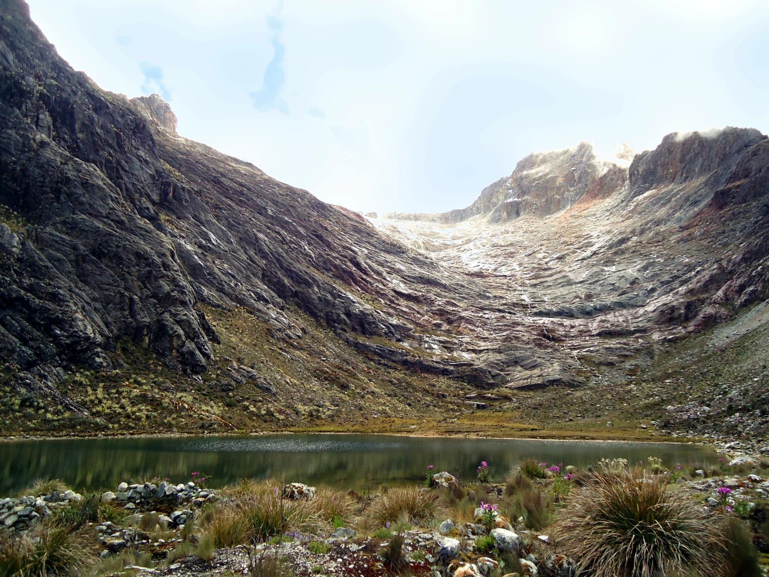
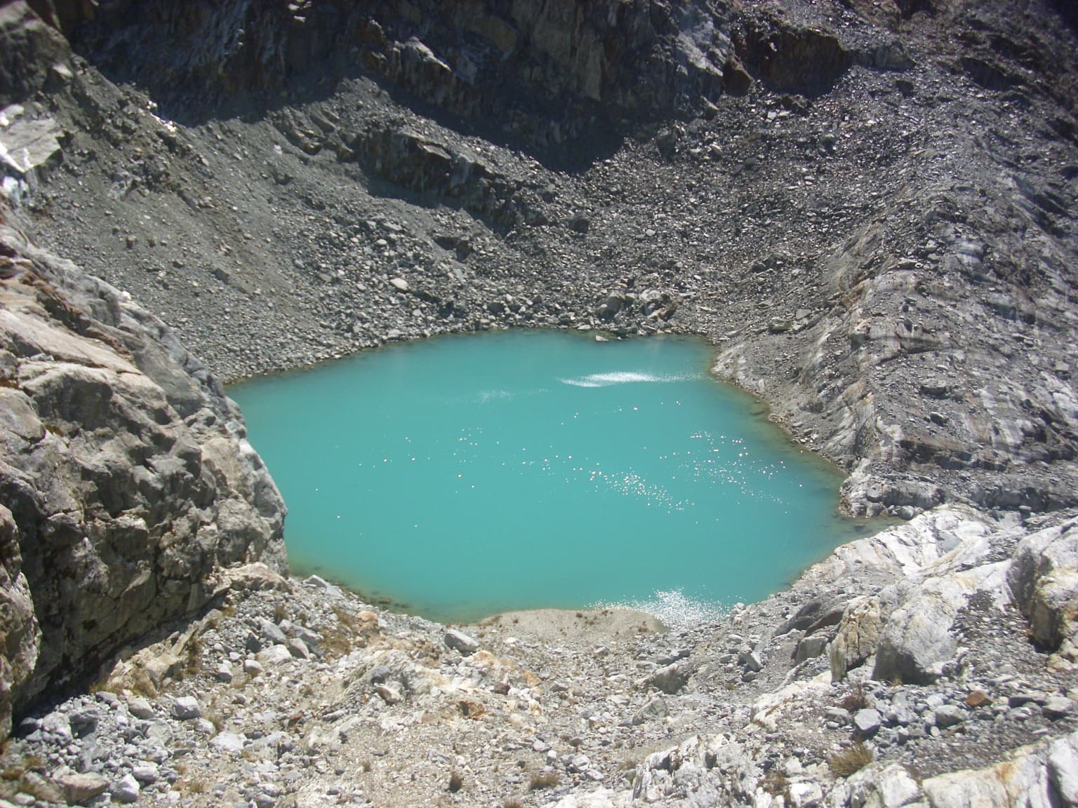
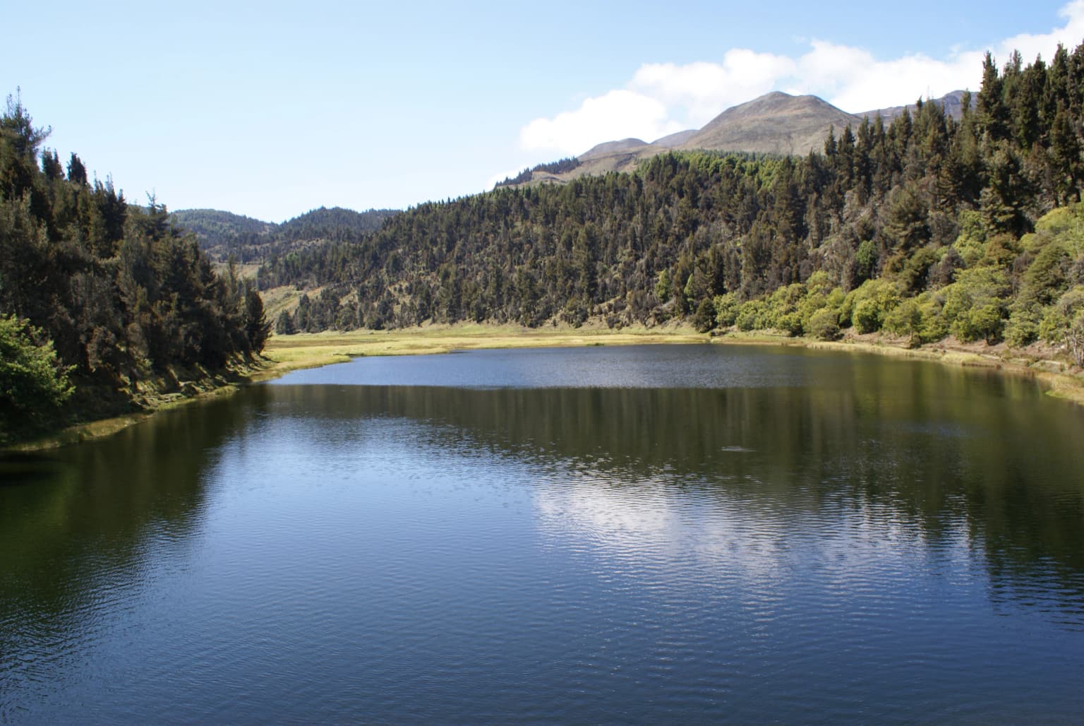
The landscape of Sierra Nevada National Park is defined by towering Andean peaks, deep glacial valleys, and dramatic elevation changes that create one of Venezuela's most visually spectacular environments. The park encompasses two major mountain ranges, the Sierra Nevada de Mérida and the Sierra de Santo Domingo, both characterized by high summits exceeding 4,500 meters, steep glacial valleys, and extensive river systems. Pico Bolívar stands as the park's and the nation's highest point at 4,978 meters, while other significant peaks include Pico Humboldt (4,942 m), Pico La Concha (4,922 m), Pico Bonpland (4,883 m), and Pico Espejo (4,609 m). The mountains are separated from neighboring ranges like Sierra La Culata by the Chama River valley to the northwest and the Santo Domingo River valley to the northeast. Within the park's boundaries lie ten lakes of glacial origin, including the notable Mucubají, La Negra, La Verde, and Los Anteojos, which have been affected by global warming but continue to characterize the high-altitude landscape. The terrain ranges from approximately 400 meters above sea level in lower valleys to nearly 5,000 meters at the highest summits, creating extraordinary topographic diversity within a single protected area.

Mountain lake surrounded by rocky terrain and high peaks under a partly cloudy sky
Partial view of Laguna del Santo Cristo, the largest mountain lake in Venezuela, within Sierra Nevada National Park

Sierra Nevada National Park ecosystems, habitats, and plant life

The ecological diversity of Sierra Nevada National Park reflects its extraordinary altitudinal range and position within the tropical Andes. The park's lower elevations feature Andean cloud forests, characterized by dense tree cover with well-developed understory layers and abundant epiphytes including orchids, bromeliads, and mosses. These forests support numerous endemic species adapted to the humid, mist-laden environment. Above approximately 3,000 meters, the vegetation transitions to distinctive páramo moorland, dominated by species of Espeletia, the iconic frailejón plants that form one of the most recognizable high-altitude ecosystems in northern South America. The park also contains xerophytic scrub vegetation in the drier areas of the Nuestra Señora river basin, particularly in the southwestern sector. In the Barinas state portion of the park, the vegetation shifts to taller forest formations reaching up to 25 meters in height. This vertical zonation from cloud forest through subalpine woodland to paramo creates a complex mosaic of habitats that supports remarkable biodiversity within a relatively confined area.

A Charolais bull stands on rocky ground with alpine vegetation under a clear blue sky.
Feral Charolais bull standing on rocky terrain at high altitude in Sierra Nevada National Park, Venezuela.

Sierra Nevada National Park wildlife and species highlights

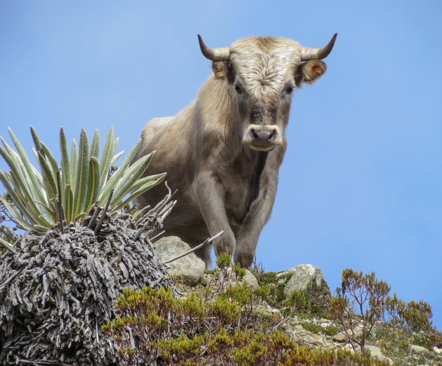
Sierra Nevada National Park shelters a remarkable array of wildlife, with the park's diverse climate and habitat variety providing refuge for numerous species. The park is most famous for population of spectacled bears, the only bear species found in the Venezuelan Andes and an endangered species that represents a conservation priority for the protected area. Other notable mammals include white-tailed deer, puma, jaguar, paca, and the moor rabbit. The Andean coati, a smaller relative of the raccoon, also inhabits the park's forests and higher elevations. The helmeted curassow, a distinctive ground bird of the Andes, is among the notable avian species found within the park, alongside the Andean guan, white-tailed quetzal, masked trogon, magpies, and the black-chested buzzard-eagle. The Andean condor, a large raptor facing extinction threats regionally, is associated with the park and has been the subject of restocking programs in neighboring Colombia. The park also contains populations of feral cattle and horses that have established themselves in the high-altitude grasslands.

Lagoon surrounded by rocky mountains with a glacier in the background, vegetation in the foreground
Laguna el Suero with mountain backdrop

Sierra Nevada National Park conservation status and protection priorities

Sierra Nevada National Park holds significant conservation value as Venezuela's premier high-altitude protected area and one of the most important Andean conservation sites in northern South America. The park protects critical habitats for the endangered spectacled bear, a species whose survival depends on the preservation of cloud forest and páramo ecosystems in the Venezuelan Andes. By encompassing both the Sierra Nevada de Mérida and Sierra de Santo Domingo ranges, the park preserves the ecological connectivity essential for wildlife movement across the high-altitude environment. The park's designation as an IUCN Category II protected area reflects its national park status and the institutional commitment to maintaining its natural values under the management of INPARQUES, Venezuela's National Park Institute. The preservation of glacial lakes and watersheds within the park provides essential ecosystem services for downstream communities while maintaining scientific understanding of high-altitude hydrological systems.

Sierra Nevada National Park cultural meaning and human context

The Sierra Nevada de Mérida holds deep cultural significance for the region, with the landscape woven into the local identity of the Venezuelan Andes. The park contains sites of religious importance including the Virgin of the Snows chapel near Pico Espejo, reflecting the traditional connection between highland communities and the alpine environment. The Our Lady of Coromoto chapel at San Rafael de Mucuchies represents another cultural landmark within the broader Andean landscape surrounding the park. These religious sites, combined with traditional land use patterns of high-altitude agriculture and pastoralism, illustrate the long-standing human relationship with this mountain environment.

A turquoise lake nestled between rocky mountain slopes with boulders in the foreground
Turquoise alpine lake surrounded by rocky mountain slopes in Sierra Nevada National Park

Top sights and standout views in Sierra Nevada National Park

The towering peaks of the Venezuelan Andes, including Pico Bolívar at 4,978 meters, form the park's most dramatic feature, offering mountaineering and alpine trekking opportunities in a tropical setting. The Mérida cable car provides unparalleled access to high-altitude environments, ascending to become one of the world's highest cable car systems with views across the Andean landscape. Glacial lakes such as Mucubají, La Verde, and Coromoto showcase the park's high-altitude hydrology and provide stunning visual anchors within the alpine environment. The endangered spectacled bear remains the park's most iconic wildlife species, drawing attention to the conservation importance of protecting these Andean ecosystems. The transition from cloud forest through paramo to permanent snow zones creates remarkable ecological diversity within a single protected area.

A calm lake surrounded by dense forest with mountain peaks visible under a partly cloudy sky
Laguna Victoria within Sierra Nevada National Park, Mérida state

Best time to visit Sierra Nevada National Park

The park experiences distinct wet and dry seasons that influence visitor experience and accessibility. The wet season from May through October brings maximum rainfall and transforms the landscape with lush vegetation and full water levels in the glacial lakes, though trail conditions may be more challenging. The dry season between December and March offers clearer skies and more stable conditions, making it generally more favorable for trekking and mountain activities. Snowfall is common throughout the year on the highest peaks, with frequent snow events from July through September becoming sporadic during the remainder of the year. The temperature range is extreme, with average temperatures varying from around 26°C in lower elevations around 400 meters to below -5°C in the highest zones above 4,900 meters, requiring visitors to prepare for varied conditions across the park's elevation gradient.

Park location guide

Geography guide, regional context, and park location map for Sierra Nevada National Park

Sierra Nevada National Park park geography, regions, and map view in Venezuela
Understand where Sierra Nevada National Park sits in Venezuela through a broader geographic reading of the surrounding landscape, nearby location context, and its mapped position within the national park landscape.

How Sierra Nevada National Park fits into Venezuela

Venezuela is a country in northern South America with coastline along the Caribbean Sea and Atlantic Ocean. It borders Colombia, Brazil, Guyana, and Trinidad and Tobago. The country has an area of approximately 916,445 km² and a population of about 31.8 million. Caracas is the capital and largest city. Venezuela consists of 23 states and the Capital District.

Wider geography shaping Sierra Nevada National Park in Venezuela

Venezuela is located on the northern coast of South America. The continental territory is bordered by the Caribbean Sea and Atlantic Ocean to the north, Colombia to the west, Brazil to the south, and Guyana to the east. Trinidad and Tobago lies to the northeast. The country includes various islands and islets in the Caribbean Sea known as the Federal Dependencies.

Map view of Sierra Nevada National Park

Use this park location map to pinpoint Sierra Nevada National Park in Venezuela, understand its exact geographic position, and read its mapped placement within the surrounding landscape more clearly.

Pigeon | © OpenStreetMap contributors

Location context for Sierra Nevada National Park

Barinas

Visual Atlas of Sierra Nevada's High-Altitude Habitats and Dramatic Protected-Area Scenery

Sierra Nevada National Park Photos: Explore Towering Andean Peaks, Glacial Lakes, and Cloud Forest Landscapes
Explore a curated visual gallery of Sierra Nevada National Park, showcasing its dramatic Andean peaks, expansive páramo ecosystems, and distinct cloud forest landscapes. These images provide an essential reference to understand the park's diverse habitats, stunning scenery, and unique protected-area character, deepening your geographic comprehension.

A village with white buildings and red-tiled roofs on a hillside with mountainous terrain in the background

A lake with mountains in the background, a wooden fence in the foreground, and people gathered at a viewing area under a partly cloudy sky

Mountain lake surrounded by rocky terrain and high peaks under a partly cloudy sky

A Charolais bull stands on rocky ground with alpine vegetation under a clear blue sky.

Lagoon surrounded by rocky mountains with a glacier in the background, vegetation in the foreground

Sunlit lake reflecting sunlight with rugged mountains and rocky shoreline under a partly cloudy sky

A turquoise lake nestled between rocky mountain slopes with boulders in the foreground

A calm lake surrounded by dense forest with mountain peaks visible under a partly cloudy sky

Waterfall cascading over rocks with mountain peaks and vegetation in background

Snow-capped mountain peak with red flowers in the foreground

Clear blue-green lake surrounded by rocky mountains and tall grasses with forested hills in the background.

Rocky mountain peaks illuminated by warm sunlight under a clear blue sky

A rocky stream flows through a valley with sparse vegetation, surrounded by rugged mountains under a clear blue sky.

Modern cable car station with large glass windows and yellow cable car on a mountain slope

Three brown horses walking in a grassy meadow with rocky terrain and mist-covered mountains in the background

Park atlas

Compare regional park geography and trace connected protected landscapes across the high Venezuelan Andes.

Explore More National Parks and Protected Areas Near Sierra Nevada National Park in the Venezuelan Andes
Explore other national parks and protected areas located near Sierra Nevada National Park, comparing their distinct Andean peaks, glacial valleys, and cloud forest or páramo ecosystems. Use this expanded geographic context to understand the broader spread of conservation landscapes across the Venezuelan Andes and discover more about regional protected area efforts.
National parkVenezuela

Sierra La Culata National Park: Protected Landscape Atlas of the Venezuelan Andes

Explore the páramo ecosystems and mapped terrain of this Venezuelan national park.

Sierra La Culata National Park offers a profound look into the unique geography of the Venezuelan Andes. This protected national park is characterized by its expansive páramo ecosystems, dramatic mountain peaks, and glacial lagoons, creating a distinctive high-altitude wilderness. Use this atlas-focused entry to understand the park's mapped boundaries and its significant role within the region's natural landscape context.

Area
2,004 km²
Established
1989
IUCN
II
Relief
Mountain
National parkBarinas

Tapo-Caparo National Park: Mapped Boundaries and Geographic Context in Barinas, Venezuela

Explore Venezuela's Tapo-Caparo National Park's protected terrain.

Tapo-Caparo National Park is a vital protected area located in the Barinas region of Venezuela. This page offers an atlas-focused exploration of its mapped natural landscape and geographic significance within the country. Understand the protected boundaries and the specific terrain features that define Tapo-Caparo National Park, providing essential context for regional geography and protected land discovery.

Area
2,050 km²
Established
1992
IUCN
II
Relief
Mountain
National parkVenezuela

Dinira National Park: Protected Watershed and Andean Mountain Landscape

Explore its rugged terrain and páramo ecosystem.

Dinira National Park is a significant protected area in Venezuela, covering rugged Andean terrain vital for watershed protection. This national park features dramatic mountain landscapes, including the Humocaro Mountains and the Los Nepes páramo zone, supporting diverse cloud forest and high-altitude ecosystems. Understanding Dinira National Park offers insight into the geographic context of the Cordillera de Mérida and its hydrological importance.

Area
453.28 km²
Established
1988
IUCN
II
Relief
Mountain
National parkLara State

Yacambú National Park National Park: Protected Cloud Forest Landscape in Lara State

Mapped terrain and significant orchid diversity in Venezuela's Andean foothills.

Yacambú National Park is a significant national park in Venezuela's Lara State, protecting crucial humid cloud forest ecosystems in the Andean foothills. The park's terrain is defined by the mountainous topography of the Portuguesa Mountain Range, supporting a rich diversity of flora, including numerous orchid species. Its role in watershed protection for nearby regions underscores its importance as a conserved natural landscape with vital ecological functions.

Area
146 km²
Established
1962
IUCN
II
Relief
Mountain
National parkVenezuela

El Guache National Park: Venezuela's Protected Andean Foothill National Park

Map exploration of vital river basins and natural landscapes.

El Guache National Park is a protected national park in Venezuela, safeguarding the headwaters of five key rivers. Its landscape comprises mountainous terrain within the Andean foothills, crucial for watershed protection and regional biodiversity. This entry provides detailed geographic context, allowing for an atlas-style exploration of the park's mapped boundaries and its role as a vital protected area.

Area
122 km²
Established
1992
IUCN
II
Relief
Mountain
National parkTáchira State

Chorro El Indio National Park: Protected National Park in Táchira State's Geography

Explore mapped boundaries and regional landscape context.

Chorro El Indio National Park serves as a key protected landscape within Táchira State, Venezuela. This national park offers users detailed insights into its specific geographic setting, mapped park boundaries, and the natural terrain it encompasses. Understanding Chorro El Indio National Park through the MoriAtlas platform provides a foundation for exploring regional protected areas and their ecological significance.

Area
170 km²
Established
1989
IUCN
II
Relief
Mountain
National parkTáchira State

El Tamá National Park: A National Park in Venezuela's Táchira State for Geographic Discovery

Mapped protected area boundaries and regional landscape context.

El Tamá National Park serves as a primary point of interest for understanding Venezuela's protected lands. Located within Táchira State, this national park offers a distinct geographic profile for atlas exploration. Users can investigate the park's mapped features and its position within the regional natural landscape, gaining insight into its role as a conservation area and a component of Venezuela's broader geography.

Area
1,390 km²
Established
1978
IUCN
II
Relief
Mountain
National parkVenezuela

Terepaima National Park: Venezuela's National Park Protected Landscape

Mapped Boundaries and Regional Geography

Terepaima National Park is a designated national park within Venezuela, offering a clear focus for atlas-driven exploration of protected natural areas. This entry highlights the park's significance as a mapped protected landscape, providing essential geographic context and detail for understanding its boundaries and regional setting. It is an integral component for any structured discovery of Venezuela's conservation network.

Area
186.5 km²
Established
1976
IUCN
II
Relief
Mountain

Common questions about visiting, size, designation, and location context for Sierra Nevada National Park

Sierra Nevada National Park FAQs for park facts, access, geography, and protected area context
Find quick answers about Sierra Nevada National Park, including protected-area facts, park geography, trail and visitor context, and how the park fits into its surrounding country and regional landscape.
MoriAtlas Explorer

Continue Your Protected Areas Search Across the Global Atlas

Deepen your exploration by continuing the structured search for national parks and protected areas worldwide. Utilize the comprehensive filtering capabilities to compare different conservation landscapes and refine your understanding of global park geography. Discover more about the distribution and characteristics of protected natural areas.

Global natural geography