
Por qué destaca Parque Nacional Cassamata Hill
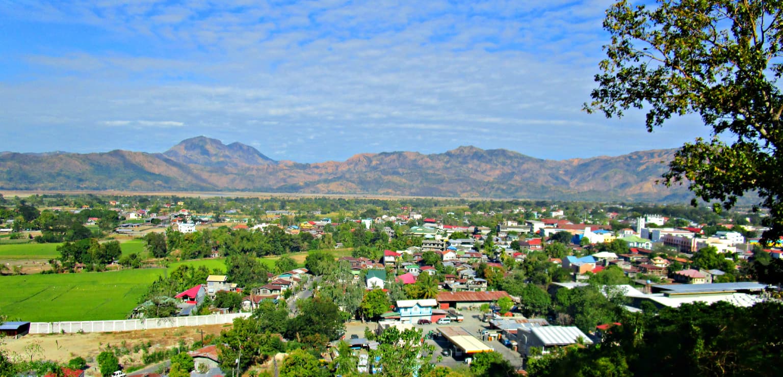
El Parque Nacional Cassamata Hill es conocido principalmente por sus amplias vistas panorámicas del valle del río Abra, que abarca el pueblo de Bangued y se extiende entre las cordilleras Central y de Ilocos. La cima del parque ofrece a los visitantes una vista impactante del Monte Banti Goolong, un pico de 990 metros cuya forma se asemeja a la de una figura reclinada, lo que le ha valido el nombre local de montaña Bella Durmiente. La combinación de recreación accesible en la cima, lugares de interés cultural como un santuario mariano y el dramático telón de fondo montañoso, otorga a este pequeño parque un carácter distintivo como mirador natural y sitio patrimonial local.
Historia de Parque Nacional Cassamata Hill y cronología del área protegida
La zona del cerro Cassamata fue designada como parque nacional protegido en 1974, estableciendo formalmente su estatus dentro de la red de áreas protegidas de Filipinas. Esta designación se produjo durante un período en el que el país estaba expandiendo su marco de conservación para incluir paisajes que combinaban valores ecológicos, escénicos y recreativos, en lugar de áreas de naturaleza virgen únicamente. El establecimiento del parque reflejó el reconocimiento de que las áreas de colinas accesibles como el cerro Cassamata podían cumplir funciones importantes como sitios de recreación en la naturaleza, al tiempo que preservaban características culturales y vistas escénicas. La gestión del parque recae en la autoridad conjunta del Departamento Nacional de Medio Ambiente y Recursos Naturales y el gobierno local del municipio de Bangued, combinando la política nacional de conservación con la capacidad administrativa local. A lo largo de las décadas, el desarrollo de infraestructuras en el lugar ha añadido instalaciones para visitantes, manteniendo la función de la cima de la colina como lugar de importancia escénica y espiritual.
Paisaje y carácter geográfico de Parque Nacional Cassamata Hill
El paisaje del Parque Nacional Cassamata Hill se caracteriza por su posición elevada sobre el valle del río Abra, siendo la colina un punto de referencia destacado en la topografía regional. La colina se eleva a través de una sinuosa carretera de acceso y escaleras de hormigón que permiten a los visitantes ascender a su cima, donde Victoria Park ofrece un mirador abierto. Desde este punto de vista, el paisaje se extiende para revelar el terreno plano o suavemente ondulado del valle del río Abra, que ha tallado un amplio corredor a través del terreno montañoso del norte de Luzón. El valle está delimitado a ambos lados por un terreno montañoso más espectacular: la cordillera Central al este y la cordillera de Ilocos al oeste. El Monte Banti Goolong, de 990 metros, comúnmente llamado Bella Durmiente por el parecido de su silueta con una forma femenina reclinada, se alza como un pico particularmente reconocible a media distancia, añadiendo drama visual a la vista desde el parque.
Ecosistemas, hábitats y flora de Parque Nacional Cassamata Hill
El carácter natural del Parque Nacional Cassamata Hill refleja su papel como paisaje protegido dentro de una región predominantemente agrícola y poblada de la provincia de Abra. Si bien el parque no es un sitio principal de conservación de la biodiversidad en el sentido de proteger hábitats críticos para especies en peligro de extinción, cumple funciones importantes como espacio verde que preserva la vegetación natural de la colina y proporciona conectividad ecológica dentro del paisaje local. La elevación del parque sobre el fondo del valle lo sitúa en una zona de transición entre las tierras agrícolas de tierras bajas y las laderas más empinadas de las montañas circundantes. Árboles y vegetación cubren las laderas y la zona de la cima de la colina, proporcionando hábitat a especies de aves comunes y pequeña fauna, al tiempo que estabilizan el suelo en las laderas de la colina.
Vida silvestre y especies destacadas de Parque Nacional Cassamata Hill
La fauna presente en el Parque Nacional Cassamata Hill refleja la posición del parque como un espacio verde accesible dentro de un paisaje de valle poblado, en lugar de un área silvestre remota. En los árboles y la vegetación del parque se pueden encontrar especies de aves comunes nativas de la región de Abra, incluyendo diversas aves canoras y especies tropicales adaptadas a la mezcla de tierras despejadas y boscosas. La vegetación del parque proporciona oportunidades de alimentación y refugio para pequeños mamíferos, mientras que el paisaje agrícola circundante sustenta poblaciones de fauna común adaptada a entornos modificados por el hombre. El valor principal de la fauna del parque reside en proporcionar hábitat para estas especies adaptables dentro de un valle de lo contrario cultivado y en el mantenimiento de un espacio verde que apoya los procesos ecológicos en el área de Bangued.
Estado de conservación y prioridades de protección de Parque Nacional Cassamata Hill
El Parque Nacional Cassamata Hill tiene importancia para la conservación como paisaje protegido de Categoría V según la clasificación de áreas protegidas de la UICN, lo que reconoce su valor para la protección de paisajes escénicos que combinan elementos naturales y culturales. La designación del parque preserva la vegetación natural de la colina y previene desarrollos que disminuirían su integridad escénica o degradarían las vistas del valle de Abra. Aunque no está designado principalmente para la protección de la biodiversidad, el parque contribuye a la red de conservación más amplia de Filipinas al mantener áreas naturales dentro de la Región Administrativa de la Cordillera. El estatus de protegido también respalda la función del parque como zona verde de amortiguación y espacio recreativo para el municipio de Bangued, proporcionando a los residentes acceso a entornos naturales sin necesidad de viajar a áreas protegidas más remotas.
Significado cultural y contexto humano de Parque Nacional Cassamata Hill
El Parque Nacional Cassamata Hill tiene una importancia cultural que va más allá de sus funciones naturales y recreativas, principalmente a través de la presencia de un santuario a la Virgen María en su cima. Este lugar religioso establece la colina como un sitio de importancia espiritual para las comunidades locales, añadiendo una dimensión cultural a la identidad del parque. La accesibilidad del parque desde la carretera principal que conecta Ilocos Sur y Abra lo ha convertido en un destino tradicional tanto para la recreación como para la peregrinación. El nombre local Bella Durmiente para el Monte Banti Goolong refleja la tradición de nombrar las características del paisaje según formas reconocibles, conectando el entorno natural con la narración cultural. El parque también sirve como espacio de reunión comunitaria para los residentes de Bangued, con instalaciones que apoyan la recreación local y las actividades sociales.
Lugares imprescindibles y vistas destacadas de Parque Nacional Cassamata Hill
Los puntos culminantes del Parque Nacional Cassamata Hill son sus vistas panorámicas desde la cima en Victoria Park, donde los visitantes pueden ver el pueblo de Bangued, el valle del río Abra y el dramático telón de fondo del Monte Banti Goolong que se alza entre las cordilleras Central y de Ilocos. La colina en sí es una subida fácil y gratificante por una carretera sinuosa o escaleras de hormigón, lo que hace que el mirador sea accesible para visitantes de distintos niveles de forma física. La combinación de paisajes naturales, patrimonio cultural a través del santuario mariano, e instalaciones recreativas construidas, incluyendo una piscina y un anfiteatro, confiere al parque un carácter multifacético. La vista de la montaña Bella Durmiente desde la cima se destaca particularmente como una característica paisajística memorable que distingue a este parque de otros miradores de la región.
Mejor época para visitar Parque Nacional Cassamata Hill
El Parque Nacional Cassamata Hill puede visitarse durante todo el año dada su ubicación en el clima tropical del norte de Luzón. La estación seca, aproximadamente de noviembre a mayo, generalmente ofrece cielos más despejados y una visibilidad más fiable desde los miradores de la cima, lo que hace que este período sea especialmente adecuado para los visitantes que buscan las mejores vistas panorámicas del valle y las montañas. La estación húmeda, de junio a octubre, trae consigo un aumento de las precipitaciones y una posible cobertura de nubes que puede reducir la visibilidad desde la colina, pero también aumenta la exuberancia de la vegetación del parque. Independientemente de la estación, visitar durante las mañanas de los días laborables suele ofrecer una experiencia más tranquila en comparación con las tardes de los fines de semana, cuando los residentes locales utilizan con frecuencia las instalaciones recreativas del parque.