Mori Atlas logo
National parkSanta Teresa National Park

Discover Uruguay's distinctive seaside national park with forested terrain and coastal geography.

Santa Teresa National Park: Protected Atlantic Coast Landscape in Rocha Department

Santa Teresa National Park represents a significant protected landscape within Uruguay's Rocha Department, uniquely situated along the Atlantic coast. This national park offers a rare fusion of dense forested terrain and sandy Atlantic beaches, providing a crucial point of reference for coastal protected areas in the region. Explore its mapped boundaries and discover the intricate natural and historic context that defines this distinctive protected landscape.

Atlantic coast parksCoastal forestsBeach parksFortified parksUruguay national parksRocha Department

Santa Teresa National Park

National park

Park overview

Structured park overview, official facts, and landscape profile for Santa Teresa National Park

Santa Teresa National Park park facts, protected area profile, and essential visitor context

Review the core facts for Santa Teresa National Park, including designation, size, terrain, visitor scale, habitats, and operating context in one park-focused overview.

About Santa Teresa National Park

Santa Teresa National Park represents an important protected area along Uruguay's Atlantic coast, where the combination of forested dunes, coastal wetlands, and sandy beaches creates a varied landscape that supports both recreation and conservation. The park's forested interior contains native vegetation adapted to the coastal environment, while its beaches provide access to the Atlantic Ocean for visitors. The presence of the historic Fort of Santa Teresa within the park boundaries adds a cultural dimension that distinguishes this protected area from purely natural reserves, creating an integrated experience where visitors can explore both natural landscapes and historical fortifications. The National Army of Uruguay maintains and supervises the park, an arrangement that has allowed for sustained management and protection of the area over many years. The park serves as a destination for both beach recreation and nature appreciation, with the camping facilities and nature reserve providing opportunities for extended visits.

Quick facts and research context for Santa Teresa National Park

Santa Teresa National Park occupies a coastal forest setting in southeastern Uruguay's Rocha Department. The park features several sandy beaches along its Atlantic coastline, including Playa de los Pesqueros, Playa del Barco, Playa Achiras, and Playa La Moza. Within its boundaries lies the historic Fort of Santa Teresa, a colonial-era fortress that gives the park its name and provides cultural depth to the natural landscape. The protected area includes a nature reserve housing various animal species, an extensive camping area, and a greenhouse displaying diverse plant collections. The park also includes a two-kilometer emergency airplane landing corridor accessible from Route 9.

Protection and recognition

Reviewing terrestrial designations, legislative framework, and official management scope.

Santa Teresa National Park Documented Protection Status and Geographic Scope

Detailed records outline the terrestrial conservation boundaries, official designation history, and legal protection framework of Santa Teresa National Park. Analyzing verified baseline data helps conservationists and visitors evaluate the ecological footprint of the park within regional environmental networks.

Protection details

Protection scope
Terrestrial
Park context

Deeper park guide and search-rich context for Santa Teresa National Park

Santa Teresa National Park history, landscape, wildlife, and travel context

Explore Santa Teresa National Park through its history, landscape character, ecosystems, wildlife, conservation priorities, cultural context, and seasonal travel timing in a structured park guide built for atlas discovery and search intent.

Why Santa Teresa National Park stands out

Santa Teresa National Park is best known for its unique combination of Atlantic coastal beaches and forested landscapes that are relatively rare in Uruguay's protected area system. The historic Fort of Santa Teresa stands as a major cultural landmark within the park, offering visitors a connection to Uruguay's colonial military history while they explore the natural environment. The park's location at the edge of Laguna Negra positions it at the intersection of marine and freshwater ecosystems, creating a distinctive ecological setting that supports diverse habitats for wildlife.

Santa Teresa National Park history and protected-area timeline

The establishment of Santa Teresa National Park reflects Uruguay's broader efforts to protect significant natural and cultural landscapes along its Atlantic coast. The park's name derives from the historic Fort of Santa Teresa, a colonial-era military fortification that predates the national park designation and remains a central feature within the protected area. The decision to place the park under the administration of the National Army of Uruguay reflects the military's historical presence in the region and its capacity to maintain and protect large tracts of land. This administrative arrangement has provided consistent resource allocation and security for the park, enabling the preservation of both the natural environment and the historical structures. The fort itself represents the strategic importance of this coastal location during Uruguay's colonial period, when fortifications protected against naval incursions and secured territorial control.

Santa Teresa National Park landscape and geographic character

The landscape of Santa Teresa National Park combines Atlantic coastal features with forested terrain that characterizes much of Uruguay's eastern seaboard. The park's coastline features several distinct beaches stretching along the Atlantic Ocean, each with characteristic sandy shores and nearshore waters. Behind the beaches, the terrain rises into forested areas that provide visual contrast and habitat diversity. The park sits adjacent to Laguna Negra, a coastal lagoon that creates an ecological transition zone between freshwater and marine environments. This proximity to a significant wetland body enhances the park's ecological value and provides visitors with views of a different water body type. The forested areas within the park contain vegetation adapted to coastal conditions, including species that tolerate salt exposure and sandy soils. The terrain is relatively flat, consistent with the coastal plain that characterizes much of Rocha Department.

Santa Teresa National Park ecosystems, habitats, and plant life

The nature of Santa Teresa National Park reflects its position along Uruguay's Atlantic coast, where marine, freshwater, and terrestrial ecosystems converge. The park's nature reserve within its boundaries provides protection for several animal species, creating an area where wildlife can persist in proximity to recreational facilities. The coastal setting supports habitats for both marine and terrestrial species, with the nearby Laguna Negra enhancing the ecological complexity by providing freshwater and wetland environments. The forest cover within the park createshabitat for land species, while the beaches and nearshore waters support marine organisms and attract seabirds. The greenhouse within the park demonstrates botanical diversity through its collection of various plant species, providing visitors with an introduction to regional flora. The combination of protected forest, coastal beach, and lagoon edge creates an ecological mosaic that supports biodiversity within a relatively limited area.

Santa Teresa National Park wildlife and species highlights

Santa Teresa National Park supports various animal species within its nature reserve, where protected habitats allow wildlife to thrive alongside human recreation. The coastal and forested environment provides suitable conditions for diverse fauna, though the Wikipedia source indicates the presence of several animal species without specifying particular species names. The proximity to Laguna Negra creates opportunities for wetland-associated wildlife, including waterfowl and other bird species that utilize both the lagoon and the park's coastal areas. The forest interior provideshabitat for terrestrial species adapted to coastal woodland, while the beach zones support species associated with sandy shores and marine environments. The variety of habitats within the park contributes to its wildlife value, allowing different species groups to find suitable conditions within the protected area.

Santa Teresa National Park conservation status and protection priorities

Santa Teresa National Park serves as an important conservation unit within Uruguay's protected area network, preserving a segment of the country's Atlantic coast that faces development pressures from tourism and coastal expansion. The park's designation as a national park reflects its recognized significance for both natural and cultural heritage, combining environmental protection with the preservation of historical structures. The forest cover within the park represents remnant coastal woodland that has been protected from conversion to agricultural or urban uses. The nature reserve designation provides heightened protection for wildlife within specific areas of the park, creating core conservation zones where species can persist with minimal disturbance. The military administration has provided consistent management capacity that supports ongoing conservation efforts, though the park also accommodates recreational uses that require balancing visitor access with protection objectives.

Santa Teresa National Park cultural meaning and human context

The cultural context of Santa Teresa National Park centers on the historic Fort of Santa Teresa, a colonial-era fortification that predates the modern protected area and represents Uruguay's military heritage along its Atlantic coast. The fort served defensive purposes during periods when coastal security was a significant concern, and its preservation within the park allows visitors to engage with this historical layer while exploring the natural environment. The park's name directly references the fort, establishing the historical structure as the defining cultural feature of the protected area. The administrative role of the National Army of Uruguay also reflects a cultural dimension, as military land management connects the park to Uruguay's institutional history. The presence of military personnel facilities, including housing near Playa del barco, indicates ongoing human presence within the park that reflects the military's continued association with this coastal area.

Top sights and standout views in Santa Teresa National Park

Santa Teresa National Park combines multiple attractions that distinguish it within Uruguay's protected area system. The historic Fort of Santa Teresa provides a unique cultural landmark that most national parks cannot offer, allowing visitors to explore colonial military architecture while surrounded by coastal forest. The park's beaches along the Atlantic coast, including Playa de los Pesqueros, Playa del Barco, Playa Achiras, and Playa La Moza, provide direct ocean access within a protected setting. The nature reserve offers wildlife observation opportunities, while the camping facilities enable extended stays. The greenhouse with diverse plant collections adds another dimension to the visitor experience. The two-kilometer emergency landing corridor on Route 9 represents an unusual feature that speaks to the park's administrative context under military management.
Monthly climate preview

Long-term temperature trends and precipitation averages in Rocha Department

Climate Normals and Monthly Weather Patterns for Santa Teresa National Park

Measured climatology averages at a representative elevation of twenty-four meters show mean monthly temperatures ranging from ten to twenty-two degrees Celsius. Exploring the complete weather by month dataset details how daily precipitation behaves alongside these thermal patterns in Rocha Department.
Annual mean17 °C
11 °C22 °C
Jan22°
Feb22°
Mar21°
Apr18°
May15°
Jun12°
Jul11°
Aug12°
Sep13°
Oct16°
Nov18°
Dec21°
Warmest month
January

22.3 °C

Coolest month
July

10.7 °C

Wettest month
February

4.2 mm/day

Driest month
November

2.7 mm/day

Park location guide

Geography guide, regional context, and park location map for Santa Teresa National Park

Santa Teresa National Park park geography, regions, and map view in Uruguay

Understand where Santa Teresa National Park sits in Uruguay through a broader geographic reading of the surrounding landscape, nearby location context, and its mapped position within the national park landscape.

How Santa Teresa National Park fits into Uruguay

Uruguay is a unitary presidential republic located in southeastern South America. It covers approximately 176,215 km² and has a population of nearly 3.5 million people. The capital and largest city is Montevideo, where roughly 2 million people live in the metropolitan area. Uruguay gained independence between 1825 and 1828 following territorial disputes involving Portugal, Spain, Brazil, and the United Provinces of the Río de la Plata.

Wider geography shaping Santa Teresa National Park in Uruguay

Uruguay is situated in the southeastern part of South America, bordering Argentina to its west and southwest, Brazil to its north and northeast, the Río de la Plata estuary to the south, and the Atlantic Ocean to the southeast. The terrain consists primarily of rolling plains and low hills, with the highest point being Cerro Catedral at approximately 514 meters. The country has several rivers including the Uruguay River, Paraná River, and Negro River.

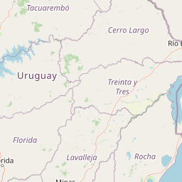
Map view of Santa Teresa National Park

Use this park location map to pinpoint Santa Teresa National Park in Uruguay, understand its exact geographic position, and read its mapped placement within the surrounding landscape more clearly.

Pigeon | © OpenStreetMap contributors

Location context for Santa Teresa National Park

Rocha Department
Park atlas

Trace the regional spread of Uruguay's protected landscapes and Atlantic coastal conservation zones.

Compare Coastal Protected Areas and National Parks Near Santa Teresa National Park

After exploring Santa Teresa National Park, continue browsing other national parks and coastal protected areas spread across Uruguay's Atlantic seaboard and Rocha Department. This expanded geographic view enables direct comparison of diverse conservation landscapes, terrain features, and historical sites within a consistent regional context.
Wildlife reserveDepartamento de Rocha
About 5.1 km away#1 closest

Northeast

Área de manejo de hábitats y/o especies Cerro Verde e Islas de la Coronilla Protected Landscape

Coastal and marine wildlife reserve in Departamento de Rocha

Spanning both land and sea, this reserve protects a rare combination of granite coastal hills, relict forests, and oceanic islands along the Uruguayan Atlantic. Learn about its integrated role within the Banos del Este biosphere and its importance as a habitat for endangered green sea turtles and migrating southern right whales.

Area
16.88 km²
Established
2011
Relief
Lowland
Climate
Temperate
National parkRocha Department
About 7.2 km away#2 closest

West

Parque Nacional Laguna Negra: Geographic Map and Protected Area Overview

Wetland and Savanna Landscapes in Rocha Department

Parque Nacional Laguna Negra protects a compressed mosaic of coastal environments in eastern Uruguay. The area integrates dense marshlands with native grasslands and patches of indigenous forest, providing a essential habitat corridor along the Atlantic coast. Use this atlas resource to understand its terrain and internal environmental distribution.

Area
7.15 km²
Established
2025
Relief
Lowland
Climate
Temperate
National parkDepartamento de Rocha
25 km away#3 closest

North

Parque nacional San Miguel: Mapped Protected Landscapes of Departamento de Rocha

Volcanic hills, native woodlands, and seasonal wetlands

Parque nacional San Miguel serves as a vital protected area, showcasing the distinctive topography of the Sierra de San Miguel. The terrain transitions from rocky volcanic slopes to expansive low-lying wetlands, creating a layered environment of native forests and open prairies that define this essential segment of the regional geography in Departamento de Rocha.

Area
15.42 km²
Established
1937
Relief
Upland
Climate
Temperate
National parkRocha
About 45 km away#4 closest

Southwest

Parque nacional Cabo Polonio: Coastal Geography and Marine Protected Area Atlas

Examining dune systems, coastal lagoons, and marine habitats

Analyze the geography of Parque nacional Cabo Polonio, a protected area in Uruguay's Rocha region. This atlas entry details the mosaic of transverse dunes, interdunal wetlands, rocky outcrops, and oceanic islands that define this significant coastal-marine protected landscape.

Area
258.2 km²
Established
2009
Relief
Lowland
Climate
Subtropical
Protected landscapeRocha
About 45 km away#5 closest

Southwest

Paisaje protegido Laguna de Castillos: Mapped Geography and Protected Landscape Features

Coastal lagoon and native woodland terrain in Rocha, Uruguay

Investigate the geographic profile of Paisaje protegido Laguna de Castillos, an essential protected area in Rocha. This terrain features the largest continuous ombú forest in the country alongside shallow coastal lagoon waters and complex wetland habitats that support a high diversity of native waterfowl.

Area
82.64 km²
Established
2020
Relief
Lowland
Climate
Subtropical
Biosphere reserveUruguay
About 66 km away#6 closest

Northwest

Reserva de biosfera Bañados del Este: Geographic Overview of Uruguay Wetlands

Mapping protected lagoons, sierras, and palm savannas

Reserva de biosfera Bañados del Este represents one of South America's most significant wetland systems. This overview highlights the ecological and physical geography of a protected area that stretches from rolling crystalline sierras down to the Atlantic coastal lagoons, examining the interplay of marshlands, grasslands, and forest remnants that shape this vital Uruguayan region.

Area
12,500 km²
Established
1976
IUCN
IV
Relief
Mixed relief
Protected landscapeRocha Department
85 km away#7 closest

Southwest

Laguna de Rocha Protected Landscape: Mapping Coastal Uruguay and its Dynamic Wetland Geography

Explore the unique barrier lagoon system and diverse coastal habitats of Rocha Department.

Laguna de Rocha functions as a vital coastal lagoon and wetland complex in southeastern Uruguay. Characterized by its shallow water and temporary sandbar breaches, the area supports a distinct mosaic of habitats, including dunes, reedbeds, and mudflats. Its status as a biosphere reserve and Important Bird Area underscores the ecological importance of this regional geography in providing a sanctuary for migratory waterbirds along the Atlantic coast.

Area
220 km²
Established
2010
Relief
Lowland
Climate
Temperate
Wildlife reserveMaldonado
About 122 km away#8 closest

Southwest

Area de manejo de habitats y/o especies Laguna Garzon: Wildlife Reserve and Coastal Atlas

Mapped wetlands and Atlantic coastal landscapes in Maldonado, Uruguay.

The Area de manejo de habitats y/o especies Laguna Garzon protected area features a unique mosaic of interconnected lagoons and dune-backed shorelines. This coastal wildlife reserve offers a significant geographic study of wetland habitats and their interaction with the Atlantic maritime zone, providing essential context for understanding Uruguay's southeastern coastal terrain.

Established
2014
Water
Water-dominated

Common questions about visiting, size, designation, and location context for Santa Teresa National Park

Santa Teresa National Park FAQs for park facts, access, geography, and protected area context

Find quick answers about Santa Teresa National Park, including protected-area facts, park geography, trail and visitor context, and how the park fits into its surrounding country and regional landscape.
MoriAtlas Explorer

Continue Your Protected Areas Search Across the Global Atlas

Deepen your exploration by continuing the structured search for national parks and protected areas worldwide. Utilize the comprehensive filtering capabilities to compare different conservation landscapes and refine your understanding of global park geography. Discover more about the distribution and characteristics of protected natural areas.

Global natural geography