Mori Atlas logo
National parkBaga National Park

Discover the mapped boundaries and geological features of this central Queensland national park.

Baga National Park: Protected Landscape & Volcanic Geography in Queensland

Baga National Park represents a unique protected landscape within central Queensland, Australia, distinguished by the dramatic trachyte volcanic plug of Mount Baga. This extinct volcano remnant rises prominently, offering a focal point for understanding the region's geological history and natural terrain. As a national park, it safeguards specific habitats and holds cultural significance, providing an accessible yet undeveloped site for exploring Queensland's distinctive geography and protected areas.

volcanic landscapebirdwatchingwetlandsQueenslandpaperbark foreststrachyte formations

Baga National Park

National park

Park overview

Structured park overview, official facts, and landscape profile for Baga National Park

Baga National Park park facts, protected area profile, and essential visitor context
Review the core facts for Baga National Park, including designation, size, terrain, visitor scale, habitats, and operating context in one park-focused overview.

About Baga National Park

Baga National Park occupies a unique position in Queensland's protected area network as a compact but ecologically and geologically significant site. The park's centerpiece, Mount Baga, is a striking trachyte volcanic plug that represents the eroded remains of an ancient volcano. This geological formation creates a dramatic backdrop against the surrounding terrain, with the trachyte rock formation rising sharply to dominate the park's skyline. The volcanic origin of this landscape is evident in the rocky exposures and the distinct character of the terrain. The park lies adjacent to the primary road connecting Rockhampton and Yeppoon, making it accessible though not heavily promoted as a tourist destination. Unlike many national parks that offer developed visitor facilities, Baga remains in a natural state without camping areas, picnic grounds, or other infrastructure, preserving its wild character and limiting visitor impact on the sensitive ecosystems present. The park's location within the broader central Queensland landscape places it within a region of mixed agricultural use and coastal communities, with the protected area serving as a biological refuge amid surrounding land uses.

Quick facts and research context for Baga National Park

Baga National Park covers 1.44 square kilometres in central Queensland, Australia, located near the coastal city of Rockhampton. The park was established in 1977 under its current name, having previously been known as Mount Jim Crow National Park. Its defining feature is Mount Baga, a trachyte volcanic plug rising from the landscape. The area supports diverse birdlife, particularly around Hedlow Creek lagoons where multiple species congregate for water. The Darumbal people hold deep cultural significance for Baga in their Dreamtime stories. No visitor facilities or camping are available.

Park context

Deeper park guide and search-rich context for Baga National Park

Baga National Park history, landscape, wildlife, and travel context
Explore Baga National Park through its history, landscape character, ecosystems, wildlife, conservation priorities, cultural context, and seasonal travel timing in a structured park guide built for atlas discovery and search intent.

Why Baga National Park stands out

Baga National Park is best known for its dramatic volcanic plug formation, Mount Baga, which stands as a prominent trachyte monolith rising from the central Queensland landscape. The park is also recognized for its birdlife, with Hedlow Creek lagoons providing critical habitat for numerous species including striated pardalotes, rainbow lorikeets, and Lewin's honeyeaters. The combination of geological significance, with the volcanic plug representing an extinct volcano's remnant, and the area's cultural importance to the Darumbal people makes this small park distinctive among Queensland's protected areas.

Baga National Park history and protected-area timeline

Baga National Park was formally established in 1977, creating protected status for the Mount Baga area and its surrounding landscapes. Prior to this designation, the area was known as Mount Jim Crow National Park, though the reasons for this earlier naming and its subsequent change to Baga are not extensively documented in available sources. The establishment of the park reflected growing recognition of the site's geological significance and the need to protect the distinctive volcanic formation from potential development pressures. The Queensland Parks and Wildlife Service assumed management responsibility for the protected area, maintaining it as a conservation-focused site without significant infrastructure development. The park's history also intersects with the longer cultural timeline of the Darumbal people, who have traditionally regarded Baga as a place of significance within their Dreamtime stories, indicating human connection to this landscape that predates formal protected area designation by thousands of years.

Baga National Park landscape and geographic character

The landscape of Baga National Park is dominated by the prominent volcanic plug of Mount Baga, a trachyte formation that rises sharply from the surrounding terrain. Trachyte, a volcanic rock of intermediate composition, forms the core of this ancient volcanic remnant, creating a distinctive light-coloured monolith that contrasts with the typically flatter surroundings of central Queensland. The volcanic plug represents the hardened magma column of a long-extinct volcano, with the softer outer material having eroded away over geological time to leave this resistant core exposed. The park's terrain includes areas of rocky exposure around the base of the plug, while lower sections support vegetation communities adapted to the local conditions. Hedlow Creek passes through the park area, creating lagoons and wetlands that provide important habitat features within the broader landscape. The overall visual character combines the dramatic vertical element of the volcanic formation with the more subtle wetland environments along the creek system.

Baga National Park ecosystems, habitats, and plant life

The nature of Baga National Park encompasses a mix of terrestrial and wetland habitats that support ecological communities adapted to central Queensland conditions. The vegetation around Mount Baga and the surrounding areas includes communities dominated by paperbark trees (Melaleuca leucadendra), which fringe the billabongs and creek channels within the park. These melaleuca forests provide important habitat structure and contribute to the biodiversity values of the area. The wetland environments associated with Hedlow Creek lagoons represent particularly significant ecological components, offering water sources that attract diverse wildlife, especially during drier periods when surface water becomes scarce across the broader landscape. The combination of rocky volcanic habitats, forested areas, and wetland zones creates a mosaic of environments within the small park boundary, supporting ecological diversity despite the limited total area.

Baga National Park wildlife and species highlights

Baga National Park supports notable birdlife, with the Hedlow Creek lagoons serving as a particular focus for avian activity. The water sources provided by these wetlands attract numerous bird species seeking drinking water and foraging opportunities, particularly during periods of limited water availability in the wider landscape. Notable species recorded within the park include striated pardalotes, which are small, active birds often associated with eucalyptus woodlands and known for their distinctive spotted plumage. Rainbow lorikeets, with their vibrant multicoloured feathers and characteristic squawking calls, are commonly observed in the park, feeding on nectar from flowering trees and shrubs. Lewin's honeyeaters also inhabit the area, adding to the diversity of honeyeater species present. The park's location within central Queensland places it within bird migration pathways and provides connectivity to broader ecological systems extending from the coast to inland areas.

Baga National Park conservation status and protection priorities

Baga National Park contributes to Queensland's protected area network by preserving a distinctive geological formation and the associated ecological communities within a relatively small boundary. The protection of Mount Baga ensures that this volcanic plug remnant remains conserved against potential development or resource extraction pressures. The wetland areas around Hedlow Creek represent ecologically significant habitats that benefit from protected status, providing refuges for waterbird species and contributing to broader landscape connectivity. The cultural significance of the area to the Darumbal people adds another dimension to the conservation value, as protected status helps maintain landscape integrity in areas of indigenous cultural importance. While the park's small size limits its capacity for extensive ecological functions, it nonetheless contributes to the representativeness of Queensland's protected areas by preserving a volcanic landscape type and associated communities.

Baga National Park cultural meaning and human context

Baga holds deep cultural significance for the Darumbal people, the traditional custodians of the land on which the park is situated. Within Darumbal Dreamtime stories, Baga is regarded as a place of considerable importance, representing one of the significant locations in the cultural landscape of this Aboriginal group. The Dreamtime, or Dreaming, refers to the mythological period when ancestral beings created the landscape, features, and cultural traditions that continue to hold meaning for Aboriginal peoples. The recognition of Baga within these stories indicates a long-standing relationship between the Darumbal people and this volcanic landscape, with the site having been a place of significance long before European settlement and the subsequent establishment of formal protected area管理制度. This cultural context adds depth to the park's identity beyond its geological and ecological values, connecting the physical landscape to ongoing Aboriginal heritage and traditional knowledge.

Top sights and standout views in Baga National Park

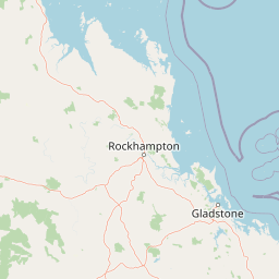
Baga National Park's primary highlight remains the dramatic Mount Baga volcanic plug, a trachyte monolith rising from the Queensland landscape as a visible reminder of ancient volcanic activity. The birdlife attracted to Hedlow Creek lagoons, particularly the presence of striated pardalotes, rainbow lorikeets, and Lewin's honeyeaters, provides a wildlife observation opportunity disproportionate to the park's small size. The accessibility of the park, situated beside the main road between Rockhampton and Yeppoon, makes it a convenient stop for travellers exploring the central Queensland coast. The lack of developed facilities contributes to a more primitive and quiet park experience, appealing to those seeking a natural environment without the infrastructure found in larger, more heavily visited protected areas.

Best time to visit Baga National Park

The best time to visit Baga National Park aligns with cooler, milder conditions that make outdoor exploration more comfortable, typically during the autumn and winter months from April to September in the southern hemisphere. During these seasons, central Queensland experiences lower temperatures and reduced rainfall, making the landscape more accessible and wildlife more active around water sources as the dry season progresses. The period from late winter through early spring can particularly suit birdwatching, as wetland areas become increasingly important as water sources and bird activity concentrates around available water. Visitors should note that no facilities exist within the park, requiring self-sufficiency for any visit, and that the summer months can bring intense heat that limits the appeal of outdoor activity in this region.

Park location guide

Geography guide, regional context, and park location map for Baga National Park

Baga National Park park geography, regions, and map view in Australia
Understand where Baga National Park sits in Australia through a broader geographic reading of the surrounding landscape, nearby location context, and its mapped position within the national park landscape.

How Baga National Park fits into Australia

Australia is a constitutional monarchy and federal parliamentary democracy comprising six states and ten territories. With a population of nearly 28 million, it is one of the world's most urbanised countries, with most people concentrated on the eastern seaboard. The country has a high Human Development Index and is known for its cultural diversity, ancient Aboriginal heritage, and unique wildlife.

Wider geography shaping Baga National Park in Australia

Australia occupies the entire Australian continent, the island of Tasmania, and numerous smaller islands. It is the world's flattest and driest inhabited continent, featuring vast deserts in the interior (the Outback), tropical rainforests along the eastern coast, and a coastline bordering the Indian and Pacific Oceans.

Map view of Baga National Park

Use this park location map to pinpoint Baga National Park in Australia, understand its exact geographic position, and read its mapped placement within the surrounding landscape more clearly.

Pigeon | © OpenStreetMap contributors

Location context for Baga National Park

Queensland
Park atlas

Discover Surrounding Protected Landscapes and Volcanic Terrain Across Australia's Central Queensland Region

Explore Other National Parks and Protected Areas Near Baga National Park, Central Queensland
Continue your exploration beyond Baga National Park to discover additional national parks and protected areas across central Queensland, Australia. This regional view allows for comparative study of diverse conservation landscapes, from prominent volcanic plugs to vital wetland habitats and coastal protected areas.
National parkQueensland

Mount Archer National Park: Queensland National Park Geography and Protected Landscape

Mapped boundaries and regional terrain discovery in northeastern Australia.

Mount Archer National Park is a designated national park contributing to the protected landscape mosaic of Queensland, Australia. This entry provides a focused look at its geographic attributes, mapped outlines, and its significance within the state's natural geography. Users exploring this protected area can gain insight into its specific landform characteristics and its role within the structured discovery offered by MoriAtlas for understanding Australia's conservation network.

Area
36.1 km²
Established
1994
IUCN
II
Relief
Mountain
National parkShire of Livingstone

Capricorn Coast National Park: Mapped Protected Area and Regional Geography

Explore its geographic setting within Shire of Livingstone.

Capricorn Coast National Park is a key protected landscape offering significant geographic detail for atlas exploration. Situated within the Shire of Livingstone, this national park's mapped boundaries and regional context are crucial for understanding its role as a protected natural area. Delve into the specific geography that shapes this Australian park and its contribution to conservation landscapes.

Area
1.14 km²
Established
1992
IUCN
II
Relief
Lowland
Watercolor illustration showing a landscape with hills, trees, and distant mountains under a light sky
National parkQueensland

Mount Etna Caves National Park: Queensland National Park Protected Landscape and Map

Explore the geographic boundaries and natural terrain of this Australian park.

Mount Etna Caves National Park is a protected national park located in Queensland, Australia. This page facilitates an atlas-style discovery of its geographic features and mapped boundaries. Understand how this protected landscape contributes to the regional geography of northeastern Australia, providing essential context for cartographic and geographic exploration.

Area
4.78 km²
Established
1994
IUCN
II
Relief
Lowland
National parkQueensland

Keppel Bay Islands National Park: Queensland's Coastal National Park and Archipelago Discovery

Explore protected islands, mapped coral reefs, and marine ecosystems.

Delve into the geographic identity of Keppel Bay Islands National Park, a significant protected area comprising thirteen islands off the coast of Queensland. This national park showcases a dynamic coastal landscape, featuring distinct island terrains, diverse marine life, and essential coral reef systems. Through its mapped boundaries and conservation focus, the park offers a unique lens for understanding island geography and the importance of marine protected areas within the broader Australian atlas.

Area
7.2 km²
Established
1994
IUCN
II
Relief
Lowland
National parkQueensland

Byfield National Park: Protected National Park with Coastal Dune Ecosystems in Queensland

Explore its mapped landscape and unique pandanus forests.

Byfield National Park presents a compelling case study in coastal protected-area geography, showcasing a diverse landscape where dune systems meet extensive pandanus forests across 12 kilometers of Queensland coastline. This national park, established in 1988, provides a unique glimpse into the ecological transition zone between tropical savanna and subtropical climates, offering a richly detailed environment for map-based exploration. Its relatively undeveloped terrain and distinct ecosystems make it a valuable entity for understanding regional Australian natural landscapes and conservation efforts.

Area
87 km²
Established
1988
IUCN
II
Relief
Lowland
National parkQueensland

Rundle Range National Park: Queensland's National Park Protected Landscape Exploration

Explore its mapped boundaries and regional geographic context.

Delve into the protected landscape of Rundle Range National Park, a designated national park situated within Queensland, Australia. This entry provides focused insights into its geographic setting, mapped park boundaries, and its significance as a protected area. It is designed to aid in understanding the park's specific natural context and its place within the broader Queensland regional geography for detailed atlas discovery.

Area
21.7 km²
Established
1993
IUCN
II
Scope
Terrestrial
National parkQueensland

Curtis Island National Park: National Park Protected Area in Queensland, Australia

Explore its mapped landscape and regional geography.

Curtis Island National Park is a designated national park offering a distinct protected landscape within Queensland, Australia. This atlas-focused entry details its geographic setting and mapped boundaries, providing essential context for understanding its place within the natural terrain of northeastern Australia. It serves as a key reference for exploring the park's specific regional geography and protected-area identity.

Area
15.5 km²
Established
1909
IUCN
II
Relief
Lowland
National parkQueensland

Mount O'Connell National Park: Queensland National Park, Protected Landscape, and Geographic Context

Discover the mapped terrain and regional boundaries within Queensland's natural geography.

Delve into Mount O'Connell National Park, a protected area offering critical insights into Queensland's regional geography and natural landscapes. This national park serves as a vital point for understanding mapped boundaries and the specific protected-area characteristics that define its identity. Users can explore its geographic context within Queensland, providing a solid foundation for atlas-driven discovery and detailed landscape analysis.

Area
7.57 km²
Established
1989
IUCN
II
Relief
Mixed relief

Common questions about visiting, size, designation, and location context for Baga National Park

Baga National Park FAQs for park facts, access, geography, and protected area context
Find quick answers about Baga National Park, including protected-area facts, park geography, trail and visitor context, and how the park fits into its surrounding country and regional landscape.
MoriAtlas Explorer

Continue Your Protected Areas Search Across the Global Atlas

Deepen your exploration by continuing the structured search for national parks and protected areas worldwide. Utilize the comprehensive filtering capabilities to compare different conservation landscapes and refine your understanding of global park geography. Discover more about the distribution and characteristics of protected natural areas.

Global natural geography