Mori Atlas logo
National parkBako National Park

Discover the mapped geography and unique biodiversity of Malaysia's oldest national park.

Bako National Park: Sarawak's Premier Protected Coastal Landscape & Ecosystem Atlas

(Taman Negara Bako)

Bako National Park, established in 1957 and located at the tip of the Muara Tebas peninsula within Kuching Division, Malaysia, represents a compact yet ecologically vital protected landscape. This oldest national park in Sarawak showcases millions of years of sandstone erosion that have sculpted a dramatic coastline of steep cliffs, rocky headlands, and sandy bays, featuring striking sea arches and seastacks. Within its approximately 27 square kilometers, Bako National Park remarkably encompasses seven distinct ecosystem types, offering a dense concentration of Borneo's natural diversity and making it a crucial site for understanding regional geography and protected-area mapping.

Coastal LandscapeRainforestProboscis MonkeysPitcher PlantsSea ArchesWildlife Watching
Illustration showing coastal cliffs, dense green forest, turquoise water, and a sunset sky

Bako National Park

National park

Park overview

Structured park overview, official facts, and landscape profile for Bako National Park

Bako National Park park facts, protected area profile, and essential visitor context
Review the core facts for Bako National Park, including designation, size, terrain, visitor scale, habitats, and operating context in one park-focused overview.

About Bako National Park

Bako National Park represents a remarkable example of ecological concentration within a compact area, protecting multiple distinct biomes that would typically require much larger territories to find together. Located at the northern tip of the Muara Tebas peninsula in Sarawak, the park sits at the confluence of the Bako and Kuching Rivers with the South China Sea, creating a landscape shaped by millions of years of sandstone erosion. The resulting terrain features a dramatic coastline of steep cliffs, rocky headlands, and white sandy bays, with wave action carving natural sea arches and distinctive seastacks along the shore. Despite its modest size of approximately 27 square kilometers, the park encompasses seven complete ecosystem types, making it a botanical treasure trove that contains nearly every plant species found across the entire island of Borneo. Visitors reach the park exclusively by boat from Kampung Bako, a journey of about 20 minutes that sets the tone for the park's secluded and natural character. The park offers 16 marked walking trails of varying lengths, allowing exploration of its diverse habitats, while additional beaches and geological features are accessible by boat. This combination of accessibility, diversity, and dramatic scenery has made Bako one of the most popular parks in Sarawak.

Quick facts and research context for Bako National Park

Bako National Park is located in Kuching Division, Sarawak, Malaysia, approximately 40 kilometers by road from Kuching city. Established in 1957, it is the oldest national park in Sarawak and one of the smallest at roughly 27 square kilometers. The park features a remarkable diversity of habitats including beach vegetation, cliff vegetation, kerangas heath forest, mangrove forest, mixed dipterocarp forest, padang grasslands, and peat swamp forest. The coastline displays dramatic sea arches and rock formations created by wave erosion, though the famous cobra-head stack collapsed in 2024. A network of 16 marked walking trails provides visitor access to the park's various landscapes and beaches.

Park context

Deeper park guide and search-rich context for Bako National Park

Bako National Park history, landscape, wildlife, and travel context
Explore Bako National Park through its history, landscape character, ecosystems, wildlife, conservation priorities, cultural context, and seasonal travel timing in a structured park guide built for atlas discovery and search intent.

Why Bako National Park stands out

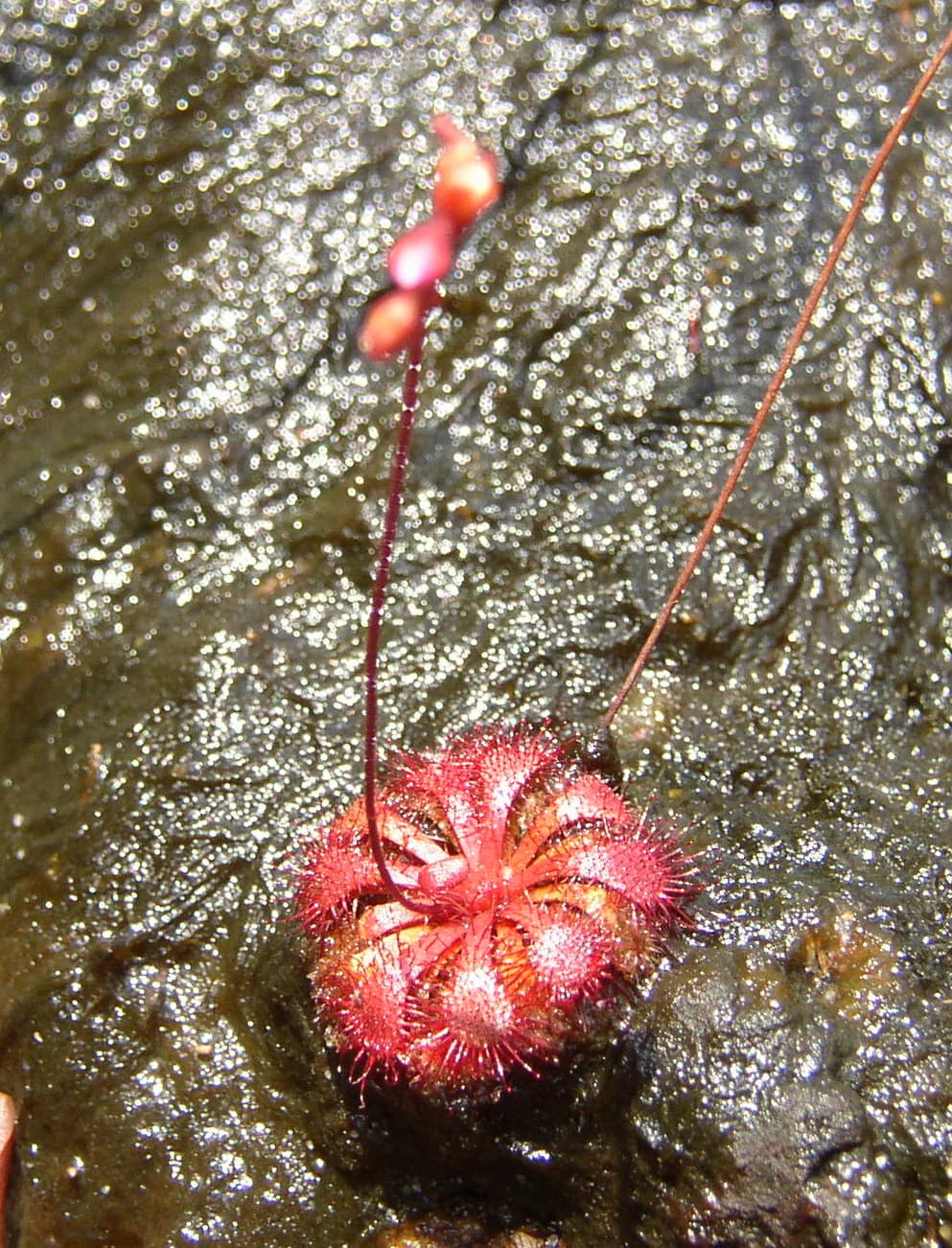
Bako National Park is best known for its population of endangered proboscis monkeys, which are endemic to Borneo. The park is widely regarded as the best place in Sarawak to observe these distinctive primates in their natural habitat. Beyond the primates, the park is celebrated for its extraordinary concentration of ecosystems in a small area, featuring almost every type of vegetation found in Borneo across just 27 square kilometers. The dramatic coastal landscape with its sea arches, seastacks, and steep sandstone cliffs provides a visually striking backdrop that complements the ecological diversity. The presence of carnivorous plants, including multiple pitcher plant species, adds another dimension to the park's botanical significance.

Forest-covered cliffs overlooking turquoise water and sandy beach, with distant mountains under partly cloudy sky
Coastal view of Bako National Park with forested cliffs and turquoise waters

Bako National Park history and protected-area timeline

Bako National Park was established in 1957, making it the oldest national park in Sarawak and one of the earliest protected areas in Malaysian Borneo. Its creation marked a pioneering effort in conservation within the region, setting a precedent for the protection of Sarawak's natural landscapes. The park's establishment came at a time when awareness of the need to preserve unique ecosystems was growing, and Bako was designated specifically to protect its exceptional botanical diversity and coastal landscapes. Over the decades, the park has remained under the management of Sarawak Forestry, which has maintained its protection while developing visitor infrastructure. The park gained international attention when it served as the final Pit Stop location for The Amazing Race Asia 1, introducing the park to a broader international audience. More recently, a significant geological change occurred in 2024 when the park's most famous sea arch, shaped like a cobra's head and visible from boats and beaches, collapsed, ending one of the park's most recognizable natural landmarks.

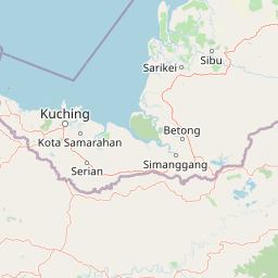
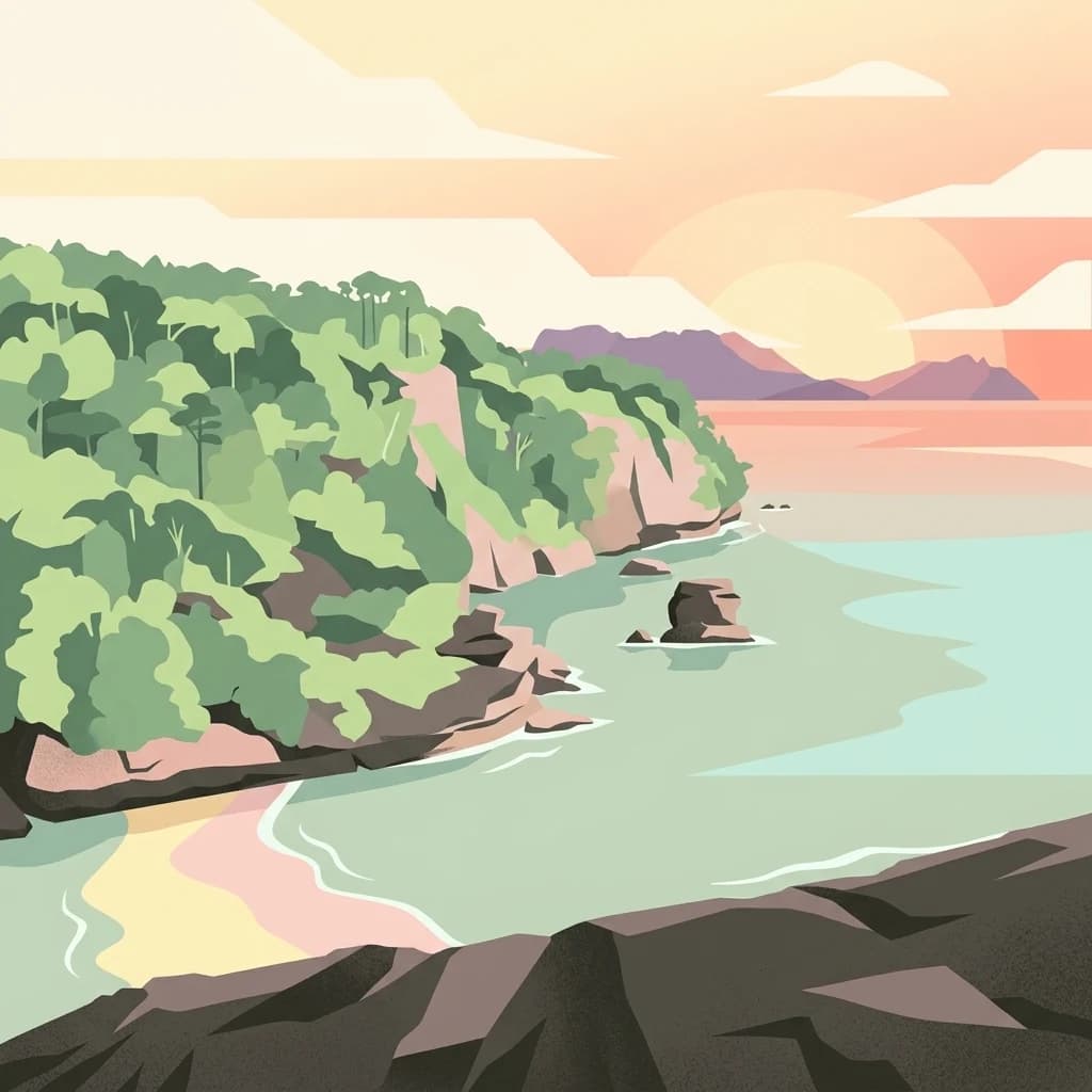
Bako National Park landscape and geographic character

The landscape of Bako National Park is defined by its dramatic coastal geology, shaped by millions of years of erosion acting on sandstone formations. The coastline features steep cliffs that rise sharply from the sea, interspersed with rocky headlands that project into the water. Between these rocky promontories lie stretches of white, sandy bays that provide visitor access to the shore. Wave erosion at the base of the cliffs has carved numerous sea arches and seastacks, creating a visually spectacular shoreline that is among the most distinctive in Borneo. The famous cobra-head rock formation, which collapsed in 2024, was perhaps the most recognizable of these features, visible from both boat rides and from various beaches within the park. The inland areas feature undulating terrain covered by rainforest, with jungle streams and waterfalls adding to the landscape's diversity. The kerangas heath forest grows on nutrient-poor sandy soils, while peat swamp forests occupy lower-lying areas, creating a mosaic of forest types across the park's small footprint.

Panoramic view of a sandy beach bordered by rocky outcrops and lush green forest, with a clear blue sky overhead
Panoramic view of Bako National Park showcasing a sandy beach, rocky formations, and dense forested coastline under a clear blue sky

Bako National Park ecosystems, habitats, and plant life

The botanical diversity of Bako National Park is extraordinary for its size, containing nearly every type of plant life found across Borneo within its 27 square kilometers. The park supports over 25 distinct vegetation types from seven complete ecosystems: beach vegetation along the shoreline, cliff vegetation on the steep coastal faces, kerangas or heath forest on the sandy soils, mangrove forest in the tidal zones, mixed dipterocarp forest in the lowland areas, padang or grassland vegetation, and peat swamp forest in the lower regions. This extraordinary concentration of habitats makes the park botanically significant far beyond what its modest size would suggest. The park is particularly notable for its carnivorous plants, including four species of pitcher plants, sundews, and bladderworts, which thrive in the nutrient-poor environments of the heath forests and peat areas. The variety of tree species and other plants is immense, with the Malaysian Wikipedia source recording 316 plant species within the park.

Close-up of red spiky carnivorous plant with flower bud on wet dark surface
Close-up of Drosera spatulata var. bakoensis plant growing in Bako National Park

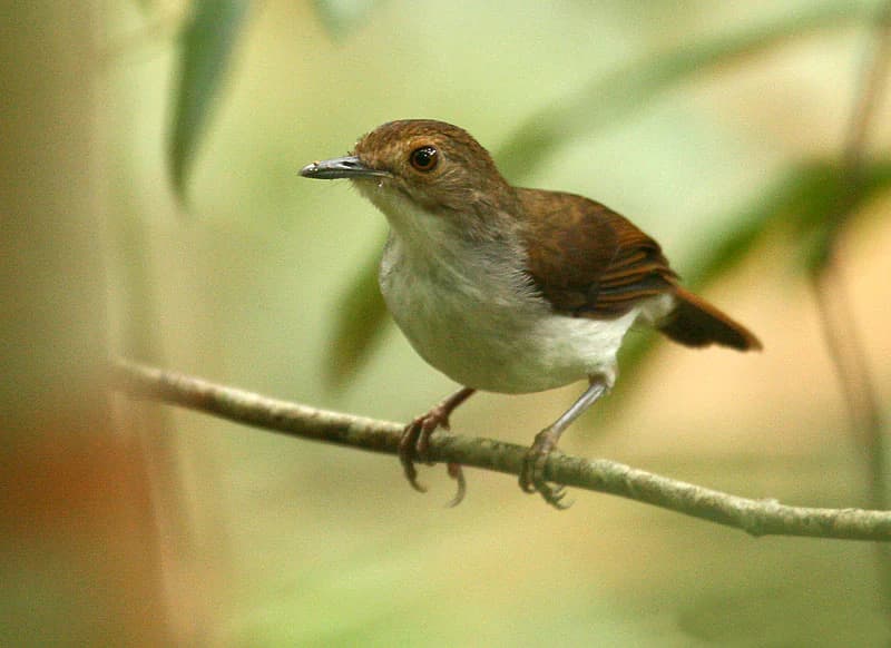
Bako National Park wildlife and species highlights

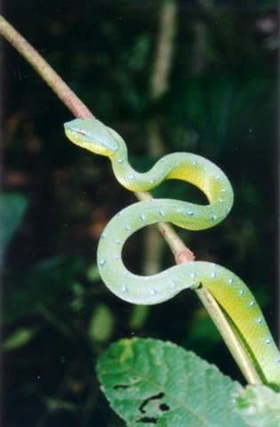
Bako National Park supports a remarkable array of wildlife, with approximately 150 endangered proboscis monkeys making the park their home. These distinctive primates, endemic to Borneo and recognizable by their large, dangling noses, represent the park's most famous animal residents, and Bako is widely considered the best place to see proboscis monkeys in Sarawak. The primate community also includes long-tailed macaques and silvered langurs, which are commonly observed in the forest and near the camp headquarters. Other mammals include the Bornean bearded pig, plantain squirrel, otter, colugo, pangolin, mousedeer, various bat species, tarsier, slow loris, and palm civet. The reptile population is diverse, with monitor lizards being commonly spotted, along with various snakes and lizards, most of which are harmless. Bird watching is particularly rewarding, with over 150 bird species recorded in the park. The nocturnal wildlife adds another dimension to the park's biodiversity, with several species only observable after dark.

Green snake with blue spots coiled on a thin branch, with a large green leaf and blurred foliage background
Asian pit viper coiled on a branch in Bako National Park

Bako National Park conservation status and protection priorities

Bako National Park was established in 1957 as the oldest national park in Sarawak, representing an early commitment to protecting the region's unique natural heritage. The park's conservation significance stems from its extraordinary botanical diversity, with seven complete ecosystems protected within a compact area, including rare kerangas heath forest and peat swamp forest habitats. The protection of proboscis monkeys is particularly important, as these endangered primates are endemic to Borneo and face habitat pressures across their range. The park's multiple ecosystem types and the presence of endangered species make it a priority area for conservation in Malaysian Borneo. The 1957 protection designation has ensured that the coastal landscapes, forest habitats, and wildlife have remained preserved despite development pressures in the surrounding region.

Bako National Park cultural meaning and human context

Bako National Park is situated within the traditional territory of Sarawak's indigenous communities, though the park itself is managed as a protected area under Sarawak Forestry. The local Malay and Melanau communities have historically interacted with the coastline and marine resources of the region. The village of Kampung Bako serves as the gateway to the park, with local boat operators providing the essential water transport that visitors require to access the park. This community relationship remains important to the park's operation, as the boat ride from Kampung Bako is the only practical means of reaching the park headquarters. The park's name in Malay, Taman Negara Bako, reflects its national park status within Malaysia's protected area system.

White-chested Babbler bird perched on a thin branch with blurred green foliage background
White-chested Babbler perched on a branch in Bako National Park

Top sights and standout views in Bako National Park

Bako National Park's highlights include its dramatic sea arch and seastack coastline, which showcases nature's erosive power over millions of years, though the famous cobra-head formation collapsed in 2024. The park's seven ecosystem types within a compact area represent an extraordinary concentration of biodiversity, with nearly every Borneo plant species represented. The endangered proboscis monkey population, approximately 150 individuals, provides the park's most iconic wildlife viewing opportunity, and Bako is recognized as the best place in Sarawak to observe these endemic primates. The network of 16 walking trails allows visitors to explore diverse habitats from beach to peat swamp forest, while the secluded beaches and boat-accessible coves offer additional exploration options. The presence of carnivorous plants, including multiple pitcher plant species, adds a botanical fascination that distinguishes the park from typical tropical forest reserves.

Sunset over a sandy beach with gentle waves, distant mountains, and a partly cloudy sky
Sunset view from the beach outside Bako National Park headquarters

Best time to visit Bako National Park

The optimal time to visit Bako National Park is during the drier months from April to September, when conditions are less humid and rainfall is reduced. The park is generally open year-round, but the period from October to March corresponds with the monsoon season, bringing heavier rainfall and higher humidity that can make outdoor activities less comfortable. The dry season offers better conditions for walking the trails and observing wildlife, though visitors should still be prepared for the tropical environment. The park can be visited as a day trip from Kuching, but those wishing to fully explore the trail network and enjoy the beaches at different times of day may prefer to stay at the campground or forestry service bungalows.

Park location guide

Geography guide, regional context, and park location map for Bako National Park

Bako National Park park geography, regions, and map view in Malaysia
Understand where Bako National Park sits in Malaysia through a broader geographic reading of the surrounding landscape, nearby location context, and its mapped position within the national park landscape.

How Bako National Park fits into Malaysia

Malaysia is a federal constitutional monarchy located in Southeast Asia. The country consists of 13 states and three federal territories, divided by the South China Sea into Peninsular Malaysia on the Indochinese Peninsula and East Malaysia on the island of Borneo. With a population of over 34 million, it achieved independence from Britain in 1957 and became a modern federation in 1963. The country is recognized for its multicultural population, tropical climate, and significant economic role in the region.

Wider geography shaping Bako National Park in Malaysia

Malaysia occupies a strategic position in Southeast Asia, split by the South China Sea into two distinct regions. Peninsular Malaysia lies on the Indochinese Peninsula, sharing a land border with Thailand to the north and maritime borders with Singapore, Vietnam, and Indonesia. East Malaysia occupies the northern portion of Borneo, sharing land borders with Brunei and Indonesia, and maritime borders with the Philippines and Vietnam. The country's terrain includes coastal plains, mountain ranges such as the Titiwangsa in the peninsula, and extensive tropical rainforests.

Map view of Bako National Park

Use this park location map to pinpoint Bako National Park in Malaysia, understand its exact geographic position, and read its mapped placement within the surrounding landscape more clearly.

Pigeon | © OpenStreetMap contributors

Location context for Bako National Park

Kuching DivisionSarawak

Visually survey Bako National Park's dramatic coastal geology, varied rainforest habitats, and rich protected-area environments.

Bako National Park: Explore Coastal Landscapes, Rainforest Scenery, and Wildlife Photography
Visually explore Bako National Park, examining its dramatic coastal scenery, lush rainforests, and distinctive protected habitats through detailed photography. These images provide essential geographic context for understanding the park's unique sandstone formations, diverse ecosystems, and the iconic wildlife found within this rich Borneo landscape.

Forest-covered cliffs overlooking turquoise water and sandy beach, with distant mountains under partly cloudy sky

A large rock formation with a narrow base and wider top standing in shallow ocean water under a clear blue sky

Panoramic view of a sandy beach bordered by rocky outcrops and lush green forest, with a clear blue sky overhead

Close-up of red spiky carnivorous plant with flower bud on wet dark surface

Green snake with blue spots coiled on a thin branch, with a large green leaf and blurred foliage background

Two brown frogs with large eyes clinging to a slender branch in a forested environment

White-chested Babbler bird perched on a thin branch with blurred green foliage background

Sunset over a sandy beach with gentle waves, distant mountains, and a partly cloudy sky

Close-up view of pitcher plants with distinctive purple pitcher-shaped leaves growing among green shrubs with hills in background

A juvenile proboscis monkey with reddish-brown fur sitting on a tree branch with green leaves and moss-covered bark

Two long-tailed macaques eating a horseshoe crab on sandy ground with scattered debris and leaves

Nepenthes gracilis plant with thin stems and leaves growing near a small muddy water pool with exposed roots and vegetation

Park atlas

Explore the Regional Spread of Protected Landscapes, Comparing Parks Along Borneo's Coastline

Discover Other National Parks and Protected Areas Near Bako National Park
After exploring Bako National Park's unique coastal geology and rich ecosystems, broaden your geographic discovery by browsing other national parks and protected areas in the surrounding Borneo region. Compare their diverse landscapes, conservation features, and wildlife to understand regional protected-area geography beyond one park.
National parkSarawak

Santubong National Park: Sarawak's Protected Landscape for Geographic Atlas Exploration

Mapped park boundaries and regional terrain context in Borneo

Delve into Santubong National Park, a significant protected area situated within the diverse geography of Sarawak, Malaysia. This resource provides detailed information on the park's mapped boundaries, allowing for focused exploration of its specific terrain and its role within the regional protected landscape atlas. Understand the geographic identity of Santubong National Park and its contribution to Borneo's conservation mapping.

Area
14.1 km²
Established
2007
IUCN
II
Relief
Mountain
National parkSarawak

Kuching Wetlands National Park: Sarawak's Protected National Park Landscape and Geography

Explore the mapped wetland boundaries and regional context.

Gain a structured understanding of Kuching Wetlands National Park, a key protected area in Sarawak, Malaysia. This detailed entry provides insights into its specific geographic identity, mapped park boundaries, and its significance as a national park within the Borneo region's extensive natural landscapes. Discover the atlas value of this protected wetland environment for comprehensive geographic exploration.

Area
84.95 km²
Established
1992
IUCN
II
Relief
Lowland
National parkSarawak

Kubah National Park: National Park Status and Mapped Landscape in Sarawak

Explore its protected boundaries and geographic context within Borneo.

Kubah National Park is a protected national park located in Sarawak, Malaysia, representing a crucial element of the region's conservation landscape. This detailed entry focuses on its identity as a national park, its specific geographic placement within Sarawak, and its significance for map-based exploration. Users can investigate the mapped boundaries and understand how Kubah National Park fits into the larger atlas of protected areas in East Malaysia, providing a factual foundation for geographic discovery without travel advice.

Area
22.3 km²
Established
1989
IUCN
II
Visitors
45K annual
National parkSarawak

Talang Satang National Park: Protected Landscape and Sarawak Geography

Explore its mapped boundaries and regional context.

Delve into the protected landscape of Talang Satang National Park, a key national park situated in the dynamic geography of Sarawak, Malaysia. This entry provides essential context for understanding its specific protected boundaries and its contribution to the broader regional natural landscape. Discover its atlas-relevant details to enrich your understanding of Borneo's protected areas and their geographic distribution.

Area
194.14 km²
Established
1999
IUCN
II
Relief
Lowland
National parkSarawak

Gunung Gading National Park: Sarawak's Protected Landscape and Geographic Context

Discover mapped terrain and protected area boundaries.

Gunung Gading National Park is an important national park located in Sarawak, Malaysia, offering critical insights into the region's geography and protected lands. This park serves as a key entity for exploring its specific mapped terrain and understanding its place within the diverse landscapes of Borneo. Examining Gunung Gading National Park aids in comprehending the distribution and character of protected areas in East Malaysia through a structured, atlas-oriented approach.

Area
43.6 km²
Established
1983
IUCN
II
Relief
Mountain
National parkMalaysia

Maludam National Park: Southeast Asian Protected Landscape and National Park Geography

Mapped boundaries and natural terrain in Malaysia.

Maludam National Park offers a focused exploration of protected landscape identity and geographic context within Malaysia. As a designated national park, it serves as a vital component for understanding the distribution of protected areas and their mapped terrain. This detailed entry allows for an appreciation of the park's specific environmental character and its contribution to the broader atlas of natural landscapes in Southeast Asia, facilitating structured discovery for researchers and explorers.

Area
432 km²
Established
2000
IUCN
II
Relief
Lowland
National parkSarawak

Rajang Mangroves National Park: Borneo's Premier Mangrove Protected Landscape

Explore the mapped geography and wetland conservation of this Sarawak national park.

Rajang Mangroves National Park is a significant protected area dedicated to preserving the intricate mangrove swamp ecosystems of Sarawak's Rajang River delta. Encompassing a vast expanse of tidal channels and riverine forests, this national park serves as a critical habitat for unique wildlife and plays a vital role in coastal ecological health. Its landscape is defined by the dynamic interface between riverine and marine environments, offering a prime example of wetland conservation within Borneo's broader natural geography and atlas context.

Area
107 km²
Established
2000
IUCN
II
Relief
Lowland
National parkKuching Division

Tanjung Datu National Park: Protected Landscape and Regional Geography

Explore its mapped boundaries within Kuching Division.

Tanjung Datu National Park is a protected natural area offering insight into regional conservation and geographic patterns within Malaysia. This entry provides a detailed look at the park's identity as a national park, focusing on its mapped boundaries and its contribution to the broader landscape context of the Kuching Division. It is designed for users seeking structured information about protected areas and their geographical distribution.

Area
7.3 km²
Established
1994
IUCN
II
Climate
Tropical

Common questions about visiting, size, designation, and location context for Bako National Park

Bako National Park FAQs for park facts, access, geography, and protected area context
Find quick answers about Bako National Park, including protected-area facts, park geography, trail and visitor context, and how the park fits into its surrounding country and regional landscape.
MoriAtlas Explorer

Continue Your Protected Areas Search Across the Global Atlas

Deepen your exploration by continuing the structured search for national parks and protected areas worldwide. Utilize the comprehensive filtering capabilities to compare different conservation landscapes and refine your understanding of global park geography. Discover more about the distribution and characteristics of protected natural areas.

Global natural geography