Why Ulu Temburong National Park stands out
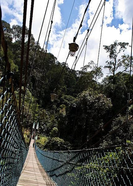
Ulu Temburong National Park is best known for its pristine lowland tropical rainforest that remains largely untouched by human development, earning it the moniker "Green Jewel of Brunei." The park offers visitors rare access to Borneo's ancient forest ecosystems through an extensive network of boardwalks, bridges, and stairways spanning seven kilometres, including a steel-frame canopy walkway rising 50 metres above the forest floor. The park protects critical habitat for the Eastern grey gibbon, a fully arboreal primate species, as well as diverse birdlife including the rhinoceros hornbill, bushy-crested hornbill, and the striking Rajah Brooke's birdwing butterfly. The park's inaccessibility by road, requiring river travel via traditional longboats piloted by experienced Iban boatmen, has preserved its wilderness character and made it a premier ecotourism destination in Brunei.
Ulu Temburong National Park history and protected-area timeline
Ulu Temburong National Park was established in 1991 as Brunei's inaugural national park, representing a landmark achievement in the sultanate's environmental protection framework. The park was created within the existing Batu Apoi Forest Reserve, building upon earlier conservation designations to provide stronger institutional protection for the area's exceptional forest ecosystems. In 1990, prior to the park's formal establishment, Universiti Brunei Darussalam established the Kuala Belalong Field Studies Centre approximately 500 metres from the mouth of the Belalong River, creating a research facility that would become vital for international scientific collaboration and environmental education. The park's ecotourism infrastructure developed gradually, with the construction of boardwalks, bridges, and stairways enabling visitor access while protecting sensitive forest areas. A significant milestone in the park's modern history occurred in November 2008 when Ulu Ulu Resort opened as Brunei's first public-private partnership in national park management, operated by Sunshine Borneo Tours and Travel under authorization from the Forestry Department. This partnership was suspended in June 2020 due to the COVID-19 pandemic, though the resort's infrastructure remains part of the park's visitor facilities.
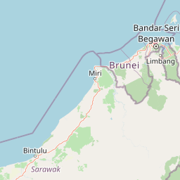
Ulu Temburong National Park landscape and geographic character
The physical landscape of Ulu Temburong National Park encompasses a remarkable diversity of terrain within its 550-square-kilometre boundary. The northern portion of the park features lowland areas with coastal influence, where the Limbang River emerges from Sarawak state in Malaysia and drains into Brunei Bay through mangrove-dominated muddy deltas. Moving southward, the terrain rises progressively through narrow river valleys carved by the Temburong and Belalong Rivers into increasingly hilly topography, culminating in mountain ridges reaching approximately 1,800 metres elevation. This elevation gradient creates distinct landscape zones from tropical lowland rainforest through lower montane forest in the southern highlands. The park's interior is characterized by steep-sided valleys, exposed rock outcrops, and cascading streams, while the river courses themselves feature sand bars, fallen logs, and boulders that create navigation challenges for the traditional longboats that provide the only access. The landscape remains largely pristine, with no road access ensuring that the forest has never been significantly disturbed by development.
Ulu Temburong National Park ecosystems, habitats, and plant life
The ecological character of Ulu Temburong National Park is defined by its position within the Borneo lowland rain forests ecoregion, one of the most biodiverse forest ecosystems on Earth. The park's vegetation is dominated by dipterocarp tree species from the Shorea, Dryobalanops, and Dipterocarpus genera, which form the canopy of the primary lowland and hill forests throughout most of the protected area. In the southern highlands above approximately 1,000 metres elevation, the forest transitions to lower montane rain forest with distinct species composition. Coastal areas in the northern park boundary support mangrove ecosystems characteristic of the Sunda Shelf mangroves. The forest understory contains abundant rattan palms, while the ground level features diverse herbaceous plants including gingers, begonias, and members of the gesneriad and aroid families. River courses support specialized vegetation including palms, ferns, mosses, and lichens, with fruiting fig trees providing critical food resources for forest-dwelling wildlife. The Belalong tree frog and earless monitor lizard represent two of the more notable endemic species discovered within the park's boundaries.
Ulu Temburong National Park wildlife and species highlights
Ulu Temburong National Park supports a remarkable diversity of wildlife despite its relatively limited geographic extent, with the Eastern grey gibbon standing out as the most charismatic arboreal species commonly observed in the forest canopy. The park's mammalian fauna includes various squirrel species, with the tiny plain pygmy squirrel frequently observed near human habitation areas, while the smooth-coated otter can be spotted along the Temburong River. The park is renowned for its butterfly diversity, with approximately 400 species documented including the rare Rajah Brooke's birdwing, whose jet black wings feature distinctive emerald green banding, and the striking tree nymph butterfly with its white and black spotted pattern. The Important Bird Area designation encompassing the park and adjacent forest reserves recognizes the site as critical habitat for numerous threatened bird species including Bornean crestless firebacks, large and cinnamon-headed green pigeons, lesser adjutants, Storm's storks, and the distinctive rhinoceros hornbill and bushy-crested hornbill. The Belalong tree frog and earless monitor lizard represent significant herpetofauna discoveries from this protected area.
Ulu Temburong National Park conservation status and protection priorities
Ulu Temburong National Park is managed by Brunei's Forestry Department within the Ministry of Primary Resources and Tourism, with the National Park Headquarters situated near the confluence of the Belalong and Temburong Rivers. The park's conservation significance extends beyond national boundaries through its inclusion in the Heart of Borneo initiative, an international conservation agreement coordinating forest protection across portions of Brunei, Malaysia, and Indonesia on the island of Borneo. The Kuala Belalong Field Studies Centre, established by Universiti Brunei Darussalam in 1990, serves as a vital research facility supporting scientific investigation and environmental education programs. BirdLife International has identified a 70,000-hectare tract encompassing the park and extensions to the Batu Apoi Forest Reserve as an Important Bird Area, recognizing the significance of its forest habitats for threatened bird species. The park's designation as Brunei's first national park in 1991 represented a commitment to maintaining representative samples of the country's forest ecosystems for future generations.
Ulu Temburong National Park cultural meaning and human context
The cultural context of Ulu Temburong National Park is closely tied to the indigenous Iban people of Borneo, whose traditional longboat navigation skills are essential for accessing the remote protected area. Visitors traveling from Bangar town to the park are transported by experienced Iban boatmen who skillfully navigate the sand bars, floating logs, and boulders that obstruct the Temburong River channel. The Iban have historically inhabited the forests of northern Borneo, and their traditional relationship with the riverine environment remains visible in the park's access procedures. The park's location within the Temburong District, Brunei's easternmost region, places it adjacent to the Malaysian state of Sarawak, creating a transboundary landscape where cultural and ecological connections extend across international borders. The park's designation as the "Green Jewel of Brunei" reflects national pride in the sultanate's successful forest protection policies, distinguishing Brunei from its more heavily forested neighbours in Borneo.
Top sights and standout views in Ulu Temburong National Park
Ulu Temburong National Park offers several outstanding features that distinguish it as Brunei's premier nature destination. The iconic canopy walkway, a steel-cable structure supported by towers and rising 50 metres above the forest floor, provides visitors with sweeping panoramic views of the Bornean rainforest canopy thatFew other protected areas can match. The seven-kilometre network of boardwalks, bridges, and stairways enables exploration of multiple forest zones while maintaining minimal ecological impact, with interpretation boards providing educational context throughout the trail system. The park's wildlife includes several species of hornbills, most notably the rhinoceros hornbill with its distinctivecasque, as well as the colourful Rajah Brooke's birdwing butterfly among hundreds of documented lepidopteran species. The opportunity to travel by traditional longboat through pristine riverine landscapes, guided by local Iban boatmen, provides a memorable arrival experience that reinforces the park's wilderness character. The research station at Kuala Belalong offers potential for scientific visitation and environmental education programs.
Best time to visit Ulu Temburong National Park
The optimal time to visit Ulu Temburong National Park generally corresponds to Brunei's dry season, which typically runs from January through March, offering more predictable weather conditions for outdoor activities and wildlife viewing. The wet season from April through December brings higher rainfall that can affect river conditions and trail accessibility, though the forest remains green and vibrant throughout the year. Temperature and humidity remain relatively constant in this tropical environment, with warm conditions prevailing year-round. Visitors should note that access to the park requires advance booking through organized tour packages that include longboat transportation, as there is no independent visitor access. The park's elevation range from coastal lowlands to 1,800-metre highlands means that higher elevation areas may experience slightly cooler and less humid conditions than the river valleys.