Mori Atlas logo
National parkChristoffelpark

Explore mapped boundaries, endemic ecosystems, and historic plantations on Curaçao's highest point.

Christoffelpark National Park: Curacao's Premier Protected Landscape & Geographic Atlas

Christoffelpark stands as Curacao's most significant national park and protected natural reserve, offering a unique atlas-style exploration of its diverse geography. This protected area encompasses the island's highest elevation, Christoffelberg, and preserves a vital dry forest ecosystem rich with endemic species. Users can delve into the mapped terrain, understand the park's landscape context, and discover the intertwined cultural heritage of historic plantations within this ecologically vital region of Curacao.

National ParkCaribbean IslandsDry ForestCactus EcosystemEndemic SpeciesColonial History

Christoffelpark

National park

Park overview

Structured park overview, official facts, and landscape profile for Christoffelpark

Christoffelpark park facts, protected area profile, and essential visitor context
Review the core facts for Christoffelpark, including designation, size, terrain, visitor scale, habitats, and operating context in one park-focused overview.

About Christoffelpark

Christoffelpark occupies a distinctive position in Curaçao's protected area network as the largest and most ecologically diverse nature reserve on the island. The park's landscape is characterized by the prominent Christoffelberg volcanic formation that rises from the north-western coastline, creating a varied terrain of slopes, valleys, and ridge lines that support multiple microhabitats. The area's ecological significance stems from its location at the transition between different vegetation zones and its relative protection from the extensive development that has altered much of Curaçao's coastline. The park encompasses three historic plantation properties that represent the agricultural foundation of colonial Curaçao, with the plantation house at Savonet now serving as the park's visitor center and museum. The management of the park by CARMABI ensures that conservation efforts are grounded in scientific research and that visitor access is balanced with the protection of sensitive habitats and cultural resources.

Quick facts and research context for Christoffelpark

Christoffelpark spans 10.4 square kilometers along the north-western coastline of Curaçao, making it the largest protected area on the island. The park was formally established in 1978 and is administered by the Caribbean Research and Management of Biodiversity Foundation. Within its boundaries lie the island's highest peak, Christoffelberg, which rises 378 meters above sea level, along with the ruins of three former plantations including Plantage Savonet, Plantage Zorgvlied, and Plantage Zevenbergen. The park contains more biodiversity than anywhere else on Curaçao, including several endemic plant species and the only known population of white-tailed deer on the island. The Savonet Museum, housed in the historic plantation house, provides visitors with insight into the property's colonial past and the people who lived and worked there.

Park context

Deeper park guide and search-rich context for Christoffelpark

Christoffelpark history, landscape, wildlife, and travel context
Explore Christoffelpark through its history, landscape character, ecosystems, wildlife, conservation priorities, cultural context, and seasonal travel timing in a structured park guide built for atlas discovery and search intent.

Why Christoffelpark stands out

Christoffelpark is best known for its dramatic landscape that combines the rugged terrain of Christoffelberg with the remnants of colonial-era plantations and unique Caribbean dry forest ecosystems. The park preserves the only significant population of white-tailed deer in Curaçao and supports exceptional biodiversity including rare orchids that bloom on towering cacti, endemic bird subspecies such as the Caribbean barn owl, and the distinctive divi-divi trees shaped by persistent trade winds. The three pillar cacti species native to the park, known locally as datu, kadushi, and kadushi di pushi, create a striking visual signature across the landscape. The park also protects important archaeological evidence of the island's plantation economy through preserved slave quarters and historical irrigation systems.

Christoffelpark history and protected-area timeline

The history of Christoffelpark is deeply intertwined with the colonial agricultural development of Curaçao. Plantation Savonet represents one of the earliest plantations established on the island, with its irrigation system still largely intact today. The plantation attempted cultivation of a variety of crops including aloe, indigofera, sorghum, corn, cotton, and beans, while also maintaining livestock such as cows, sheep, goats, and poultry. The plantation houses at Savonet and Zorgvlied were constructed during the eighteenth century and represent architectural examples of colonial-era building in Curaçao. Zorgvlied now exists only as ruins, though the house of the bomba, the enslaved worker responsible for overseeing other enslaved laborers, remains preserved nearby alongside a traditional slave-pole. The roads through the park were paved in 2004, improving visitor access while maintaining the integrity of the cultural landscape. The park was formally established as part of Curaçao's national park system in 1978, creating the legal framework for its long-term protection.

Christoffelpark landscape and geographic character

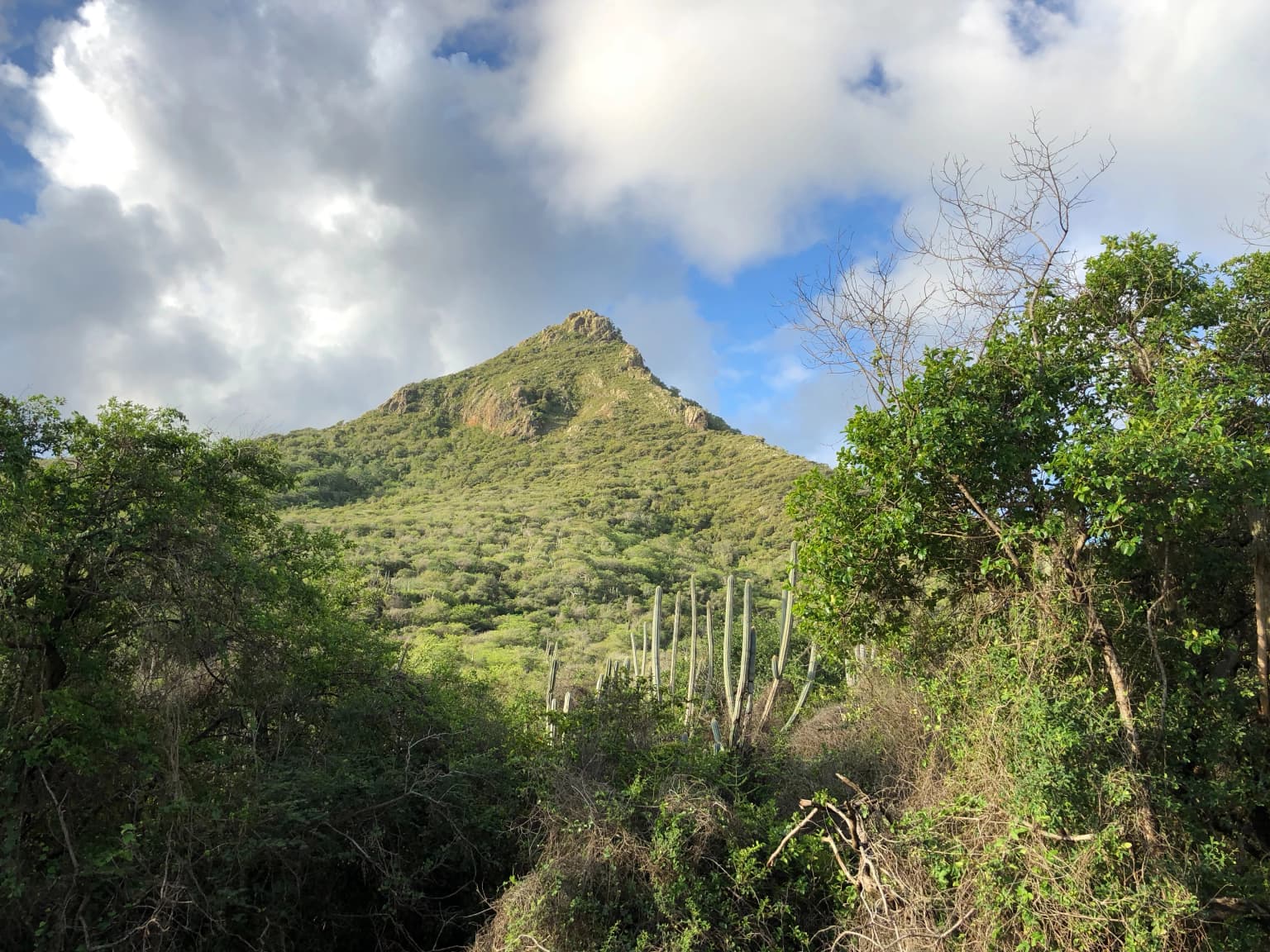
The landscape of Christoffelpark is defined by the dramatic volcanic mass of Christoffelberg, which rises as the highest point on Curaçao and creates a striking backdrop visible from much of the island's north-western coast. The terrain consists of rocky slopes, limestone outcrops, and dry riverbeds that channel seasonal rainfall through the reserve. The park's elevation gradient from sea level to 378 meters supports distinct vegetation zones, with drier cactus-dominated areas at lower elevations giving way to more lush vegetation in the higher reaches where moisture collects. The three historic plantations are situated in different landscape settings within the park, with Savonet located near the park entrance at a lower elevation while Zorgvlied occupies a mountain-side position. The landscape is punctuated by the distinctive silhouette of divi-divi trees, whose branches have been permanently sculpted by the persistent trade winds that sweep across the island. Views from Christoffelberg's summit encompass both the park's interior and the Caribbean Sea, providing a sweeping perspective on Curaçao's geography.

Christoffelpark ecosystems, habitats, and plant life

Christoffelpark supports the most extensive dry forest ecosystem remaining on Curaçao, with vegetation adapted to the island's semi-arid climate and poor soils. The park's flora includes more than three hundred plant species, with cacti and succulents forming a dominant component of the landscape. Three species of pillar cacti, locally known as datu, kadushi, and kadushi di pushi, reach heights of up to three meters and provide important habitat for orchids and other epiphytic species. The park preserves several extremely rare orchids including the lady of the night and Humboldt's schomburgkia, which bloom on the trunks and branches of cacti and trees. Two plant species are endemic to Christoffelpark and surrounding areas, including Myrcia curassavica found only within the park boundaries and Maytenus versluysii, which also occurs on nearby Bonaire. The divi-divi tree, with its characteristic wind-shaped form, is a signature species of the Caribbean dry forest and appears throughout the park.

Christoffelpark wildlife and species highlights

The wildlife population in Christoffelpark represents the most diverse assemblage found anywhere on Curaçao. Mammals in the park include the white-tailed deer, which exists as the only substantial population of this species on the island, the eastern cottontail, and several species of bats that roost in the park's caves and rock crevices. The bird fauna is particularly significant, with the white-tailed hawk representing a rare raptor species and the park supporting an endemic subspecies of barn owl known as Tyto alba bargei. Hummingbirds are well represented, with the common emerald and ruby topaz commonly observed feeding on flowering plants throughout the park. The endemic yellow oriole, a distinctive Caribbean bird species, nests and feeds within the park's forest canopies. Reptiles and insects complete the vertebrate fauna, with various lizard and gecko species inhabiting the rocky terrain and diverse insect communities supporting the food web.

Christoffelpark conservation status and protection priorities

Christoffelpark plays a central role in Curaçao's conservation framework as the largest protected area in the national park system and an important component of the North-east Curaçao parks and coast Important Bird Area. The designation of the park as an IUCN Category II protected area recognizes its significance for biodiversity conservation while allowing sustainable visitor use and environmental education. The CARMABI Foundation manages the park based on scientific research and conservation best practices, balancing ecological protection with public access. The park's strict nature reserve zone of 1,040 hectares provides maximum protection for the most sensitive habitats and endemic species, while the broader park area allows for controlled tourism activities that support local awareness of conservation needs. The protection of the white-tailed deer population is particularly significant, as this species has been eliminated from most of Curaçao due to hunting pressure and habitat loss.

Christoffelpark cultural meaning and human context

The cultural landscape of Christoffelpark reflects the complex colonial history of Curaçao and the island's role in transatlantic slavery and agricultural exploitation. The three plantation sites within the park, including Savonet, Zorgvlied, and Zevenbergen, represent the agricultural economy that developed under Dutch colonial rule. Plantation Savonet, as one of the earliest plantations on the island, contains archaeological evidence of the systems and structures that supported large-scale agricultural operations. The preserved house of the bomba and the slave-pole near Zorgvlied provide direct evidence of the enslaved population that worked the plantations. The Savonet Museum, housed in the historic plantation house, interprets this history for visitors and documents the lives of both the plantation owners and the enslaved workers who lived on the property. This cultural heritage adds a meaningful dimension to the park's natural values, creating a space where ecological restoration and historical commemoration intersect.

Top sights and standout views in Christoffelpark

Christoffelpark offers visitors multiple ways to experience its unique combination of natural and cultural heritage. The climb to the summit of Christoffelberg represents the park's most challenging and rewarding hiking opportunity, providing panoramic views across the island and sea. The eight marked hiking trails traverse diverse terrain through cacti forests, past historic plantation ruins, and along ridge lines with sweeping vistas. The Savonet Museum provides context for understanding the plantation economy and the people who shaped the landscape over centuries. Wildlife viewing opportunities include the chance to observe white-tailed deer, endemic birds, and the diverse cacti ecosystem. The park's four sealed roads allow visitors to explore by vehicle, while organized tours offer specialized experiences such as deer-spotting excursions at sunset and historical walks focusing on the plantation sites.

Best time to visit Christoffelpark

The optimal time to visit Christoffelpark depends on the experience sought, though the dry season from April through September offers the most reliable conditions for outdoor exploration. The park opens at 6 each morning, and visitors intending to climb Christoffelberg are advised to begin their ascent early in the day to avoid the intense heat that builds on the exposed slopes. The early morning hours also provide the best opportunities for wildlife observation as animals are more active during the cooler parts of the day. The park closes to new entries at 1:30 in the afternoon, making early arrival essential for those planning comprehensive visits. The period from December through March coincides with the height of the bird migration season, offering increased chances to observe migratory species passing through the area. Visitors should note that the landscape appears most verdant shortly after the rainy season, which typically runs from October through December, though rainfall is generally limited throughout the year.

Park location guide

Geography guide, regional context, and park location map for Christoffelpark

Christoffelpark park geography, regions, and map view in Curacao
Understand where Christoffelpark sits in Curacao through a broader geographic reading of the surrounding landscape, nearby location context, and its mapped position within the national park landscape.

How Christoffelpark fits into Curacao

Curaçao is a Caribbean island country and constituent territory of the Kingdom of the Netherlands. Located in the Dutch Caribbean region, it is the largest of the ABC islands (along with Aruba and Bonaire). The island is famous for its distinctive blue Curaçao liqueur made from the laraha citrus fruit. It has a population of around 156,000 and is known for its Dutch colonial architecture in Willemstad, which is a UNESCO World Heritage Site.

Wider geography shaping Christoffelpark in Curacao

Curaçao is located in the southern Caribbean Sea, approximately 65 km north of Venezuela and 80 km southeast of Aruba. The island is part of the ABC islands alongside Aruba and Bonaire. The terrain is generally hilly with a relatively flat interior, reaching a highest elevation of 372 meters. The coastline features beaches and rocky shores.

Map view of Christoffelpark

Use this park location map to pinpoint Christoffelpark in Curacao, understand its exact geographic position, and read its mapped placement within the surrounding landscape more clearly.

Pigeon | © OpenStreetMap contributors
Park atlas

Discover the Diverse Protected Geography of Curaçao and the Wider Caribbean, Expanding Your Atlas View Beyond Christoffelpark

Explore More Protected Areas Near Christoffelpark, Compare Regional Parks, and Trace Nearby Caribbean Protected Landscapes
Expand your protected area discovery from Christoffelpark by exploring other national parks and conserved landscapes across Curaçao and the surrounding Caribbean region. Compare varied ecosystems, trace regional park geography, and deepen your understanding of the diverse conservation efforts and natural heritage throughout the islands.
National parkFalcón State

Médanos de Coro National Park: Venezuela's Unique Arid Landscape and Protected Dune System

Explore the mapped geography of this coastal desert in Falcón State.

Médanos de Coro National Park represents a remarkable protected area within Venezuela's Falcón State, renowned for its spectacular and active sand dune systems. This national park encompasses approximately 91 square kilometers of unique terrain, including large sand formations, salt marshes, and mangrove swamps, contributing to its designation as a key conservation site for arid coastal ecosystems. Users can explore the park's distinctive landscape, understand its geographic context, and discover the patterns of wind-sculpted dunes that define this Venezuelan national park.

Area
91 km²
Established
1974
IUCN
II
National parkVenezuela

Morrocoy National Park: Venezuela's Coastal National Park with Distinct Protected Geography

Explore the mapped protected landscape and regional context.

Morrocoy National Park stands as a key protected area within Venezuela, offering a distinct focus for geographic exploration. As a national park, its mapped boundaries delineate a significant natural landscape critical for understanding regional conservation and the country's broader atlas of protected lands. Discover the unique geographic characteristics and the atlas-driven context of this important Venezuelan protected area.

Area
320.9 km²
Established
1974
IUCN
II
National parkCarabobo

San Esteban National Park: Discover Carabobo's Protected Caribbean Forest Landscape

Mapped protected area and natural terrain in Venezuela.

San Esteban National Park represents a significant protected area within Venezuela's Carabobo region, offering a unique exploration of Caribbean forest ecosystems and historical cultural sites. Covering approximately 445 square kilometers, the park's terrain spans coastal areas to mountainous interiors, presenting a diverse natural landscape shaped by its position in the coastal mountain ranges. This national park is notable for its archaeological petroglyphs, colonial roads, and fortifications, providing a rich cultural heritage context alongside its natural ecosystems. Its status as a protected national park makes it a key destination for understanding the intersection of natural conservation and historical geography in Venezuela.

Area
445 km²
Established
1987
IUCN
II
National parkVenezuela

Henri Pittier National Park: Venezuela's Oldest National Park, Coastal Range Geography

Explore protected landscapes, cloud forests, and birdwatching geography.

Henri Pittier National Park is Venezuela's foundational protected area, established in 1937 and spanning over 107,800 hectares within the Venezuelan Coastal Range. This national park is renowned for its exceptional biodiversity, particularly its over 500 bird species and its distinctive cloud forest ecosystems, which include the iconic Gyranthera caribensis tree. The park's geography extends from rugged mountain terrain to coastal bays and beaches, with the Paso de Portachuelo serving as a significant migratory bird corridor. Its mapped boundaries enclose a rich mosaic of natural landscapes vital for understanding regional conservation and protected area geography in northern South America.

Area
1,078 km²
Established
1937
IUCN
II
Relief
Mountain
National parkLara State

Yacambú National Park National Park: Protected Cloud Forest Landscape in Lara State

Mapped terrain and significant orchid diversity in Venezuela's Andean foothills.

Yacambú National Park is a significant national park in Venezuela's Lara State, protecting crucial humid cloud forest ecosystems in the Andean foothills. The park's terrain is defined by the mountainous topography of the Portuguesa Mountain Range, supporting a rich diversity of flora, including numerous orchid species. Its role in watershed protection for nearby regions underscores its importance as a conserved natural landscape with vital ecological functions.

Area
146 km²
Established
1962
IUCN
II
National parkVenezuela

El Guache National Park: Venezuela's Protected Andean Foothill National Park

Map exploration of vital river basins and natural landscapes.

El Guache National Park is a protected national park in Venezuela, safeguarding the headwaters of five key rivers. Its landscape comprises mountainous terrain within the Andean foothills, crucial for watershed protection and regional biodiversity. This entry provides detailed geographic context, allowing for an atlas-style exploration of the park's mapped boundaries and its role as a vital protected area.

Area
122 km²
Established
1992
IUCN
II
National parkVenezuela

El Ávila National Park: Venezuela's Premier Coastal Mountain National Park Exploration

Discover diverse terrain, mapped boundaries, and unique geographic context.

El Ávila National Park offers an exceptional gateway into Venezuela's mountainous protected landscapes. This national park features a dramatic rise from the Caribbean coast into varied terrain, including unique cloud forest and alpine zones. Its mapped geography showcases steep slopes, deep ravines, and remarkable elevation changes, providing a significant atlas-style study of coastal mountain environments. Exploring El Ávila National Park reveals a vital natural barrier and a rich ecosystem supporting diverse flora and fauna, making it a key destination for understanding regional protected areas.

Area
819 km²
Established
1958
IUCN
II
National parkVenezuela

Dinira National Park: Protected Watershed and Andean Mountain Landscape

Explore its rugged terrain and páramo ecosystem.

Dinira National Park is a significant protected area in Venezuela, covering rugged Andean terrain vital for watershed protection. This national park features dramatic mountain landscapes, including the Humocaro Mountains and the Los Nepes páramo zone, supporting diverse cloud forest and high-altitude ecosystems. Understanding Dinira National Park offers insight into the geographic context of the Cordillera de Mérida and its hydrological importance.

Area
453.28 km²
Established
1988
IUCN
II

Common questions about visiting, size, designation, and location context for Christoffelpark

Christoffelpark FAQs for park facts, access, geography, and protected area context
Find quick answers about Christoffelpark, including protected-area facts, park geography, trail and visitor context, and how the park fits into its surrounding country and regional landscape.
MoriAtlas Explorer

Continue Your Protected Areas Search Across the Global Atlas

Deepen your exploration by continuing the structured search for national parks and protected areas worldwide. Utilize the comprehensive filtering capabilities to compare different conservation landscapes and refine your understanding of global park geography. Discover more about the distribution and characteristics of protected natural areas.

Global natural geography