Mori Atlas logo
National parkDoi Khun Tan National Park

Discover the mapped boundaries and diverse forest terrain of this key national park in Lamphun Province.

Doi Khun Tan National Park: Protected Mountain Landscape and Historic Tunnel Geography

Doi Khun Tan National Park in northern Thailand represents a significant protected landscape, spanning the rugged Khun Tan mountain range. This national park showcases a dynamic geography, rising from lowlands to over 1,300 meters, supporting distinct forest types from lowland teak woodlands to upland evergreen forests. Its mapped boundaries encompass terrain notable for ecological diversity and the iconic Khun Tan Tunnel, a historic engineering feat cut through the mountains, offering a unique intersection of natural heritage and human history within Lamphun Province's geography.

National ParkMountain ForestPine ForestNorthern ThailandKhun Tan RangeRailway History

Doi Khun Tan National Park

National park

Park overview

Structured park overview, official facts, and landscape profile for Doi Khun Tan National Park

Doi Khun Tan National Park park facts, protected area profile, and essential visitor context
Review the core facts for Doi Khun Tan National Park, including designation, size, terrain, visitor scale, habitats, and operating context in one park-focused overview.

About Doi Khun Tan National Park

Doi Khun Tan National Park protects a significant portion of the Khun Tan Range in northern Thailand, spanning the provinces of Lamphun and Lampang. Established in 1975 as Thailand's tenth national park, the park encompasses approximately 255 square kilometres of mountainous terrain characterized by steep ridgelines, valleys, and forested slopes. The area was originally designated as a reserved forest in 1963 and 1968 before being upgraded to national park status, making it one of Thailand's older protected areas. The park's elevation gradient from 325 to 1,373 metres creates diverse microclimates and habitat conditions that support complex ecological communities. Beyond its natural significance, the park contains historically important infrastructure including the Khun Tan Railway Station and the associated tunnel, which represent significant engineering achievements from Thailand's railway development period. The park is managed by the Department of National Parks, Wildlife and Plant Conservation and remains an important conservation area in northern Thailand despite facing challenges from historical human encroachment and forest modification.

Quick facts and research context for Doi Khun Tan National Park

Doi Khun Tan National Park occupies the Khun Tan Range in northern Thailand, straddling Lamphun and Lampang Provinces. The park was established in 1975 and covers 255 square kilometres with elevations ranging from 325 to 1,373 metres. It is Thailand's tenth national park and an IUCN Category II protected area. The climate features three distinct seasons: a hot summer from March to June, a rainy season from July to October, and a cool winter from November to February, with temperatures ranging from 5°C to 38°C and average annual rainfall of approximately 1,034 mm. The park contains over 1,300 vascular plant species and features Thailand's longest railroad tunnel at Khun Tan.

Park context

Deeper park guide and search-rich context for Doi Khun Tan National Park

Doi Khun Tan National Park history, landscape, wildlife, and travel context
Explore Doi Khun Tan National Park through its history, landscape character, ecosystems, wildlife, conservation priorities, cultural context, and seasonal travel timing in a structured park guide built for atlas discovery and search intent.

Why Doi Khun Tan National Park stands out

Doi Khun Tan is best known for two interconnected features: its role as a biodiverse protected mountain ecosystem in northern Thailand and the famous Khun Tan Tunnel, Thailand's longest railroad tunnel at 1,352 metres in length. The tunnel was built by German engineers during the early 20th century and remains a remarkable engineering achievement. The park also stands out for its three distinct forest types that create a vertical ecological gradient from lowland teak forests through transitional mixed woodlands to upland evergreen forests, supporting remarkable botanical diversity with over 1,300 vascular plant species including numerous orchids and gingers. The combination of significant natural heritage and historic infrastructure creates a park with both ecological and cultural value.

Doi Khun Tan National Park history and protected-area timeline

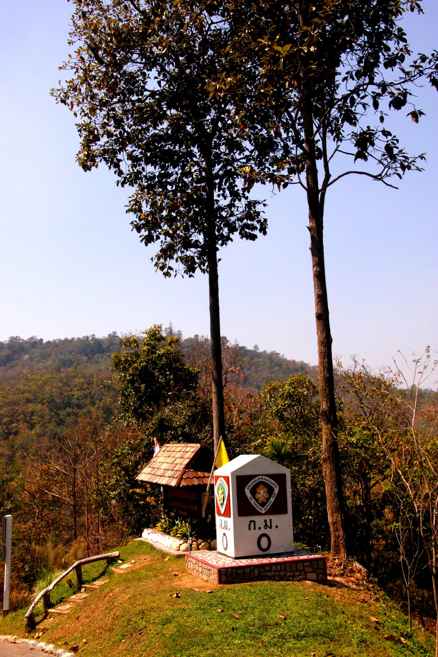
Doi Khun Tan National Park was formally established on March 5, 1975 (BE 2518), making it Thailand's tenth national park and one of the earliest additions to the country's protected area network. The protected area originated from earlier conservation efforts when portions of the forest were declared reserved forests under ministerial regulations. In 1963, portions of the area in Lamphun Province covering approximately 39,206 rai were designated as Doi Khun Tan Reserved Forest under Cabinet resolution. Additional areas in Lampang Province covering about 120,625 rai were added to the reserved forest system in 1968. The park's creation reflected Thailand's growing commitment to conservation during this period, with the Khun Tan Range being recognized for its watershed value, ecological diversity, and forest resources. The area also carries historical significance related to the construction of Thailand's northern railway line, particularly the Khun Tan Tunnel, which was built by German engineers and remains the country's longest railroad tunnel. Historical figures including royalty and foreign dignitaries have had connections to the area, with royal visits recorded during the 1960s and 1970s.

Doi Khun Tan National Park landscape and geographic character

The landscape of Doi Khun Tan National Park is defined by the rugged Khun Tan Range, a mountain chain running through northern Thailand with steep slopes, narrow valleys, and forested ridgelines. The terrain rises from approximately 325 metres at the lower boundaries to 1,373 metres at the highest peaks, creating dramatic topographic variation across the park. The mountain slopes are covered with varying forest types that follow the elevation gradient, with dense vegetation in the middle and upper elevations contrasting with more open woodland at lower altitudes. The park contains several notable peaks and scenic viewpoints, including the summit of Doi Khun Tan which offers panoramic views over the surrounding countryside. The railway line and tunnel corridor cut through the lower slopes of the range, creating a distinctive human modification within the natural mountain landscape. The combination of forested slopes, rocky outcrops, and the historic railway infrastructure creates a landscape of mixed natural and historical character.

Doi Khun Tan National Park ecosystems, habitats, and plant life

The ecological character of Doi Khun Tan is defined by its three distinct forest types arranged along the elevation gradient. At lower elevations between 325 and 850 metres, the forest originally consisted of teak woodlands but has been degraded to mixed bamboo deciduous and deciduous Dipterocarp-oak forest through human activity. The middle elevation zone from 850 to 1,000 metres serves as a transitional area where lowland deciduous forest meets upland evergreen-pine forest, creating a mixed evergreen and deciduous woodland. This zone contains both of Thailand's pine species, Pinus latteri (a two-needle pine) and Pinus kesiya (a three-needle pine). Above 1,000 metres to the highest elevations of 1,373 metres, the forest is dominated by evergreen hardwood trees with occasional Pinus latteri, forming an evergreen-pine forest community. The park supports exceptional botanical diversity with over 1,300 vascular plant species documented, including numerous wild-flowers such as orchids and gingers that can be viewed year-round. Edible fungi are also found throughout the park. The more pristine forest conditions are now found on the eastern side of the park, while the western side has suffered more significantly from historical deforestation and watershed degradation.

Doi Khun Tan National Park wildlife and species highlights

The wildlife community of Doi Khun Tan has been significantly affected by historical human activities including hunting, logging, frequent fires, and encroachment. Remaining species present in the park include the Siamese hare, porcupine, wild chicken, wild boar, and weasel, along with various bird species, reptiles, spiders, and insects. The park offers year-round opportunities for wildlife observation, particularly for birdwatching. Historically, the area supported a much richer fauna including gibbons, tigers, elephants, bears, wild cattle, serow, slow loris, and barking deer, but these species have been extirpated from the park due to hunting pressure and habitat loss. The reduction in large mammal populations represents a significant change from the park's historical ecological character and highlights the conservation challenges facing Thailand's forest ecosystems. Birdlife in the park includes species such as green magpies, greater flamebacks, mountain babblers, and white-throated rock thrushes, particularly observable in the higher elevation forest areas.

Doi Khun Tan National Park conservation status and protection priorities

Doi Khun Tan National Park holds significance as one of Thailand's older protected areas, designated as an IUCN Category II (national park) protected area reflecting its primary conservation purpose. The park serves important watershed functions, protecting the headwaters and forested slopes of the Khun Tan Range that contribute to broader catchment health in the region. The three distinct forest communities, while degraded from their original condition, still provide important habitat value and ecological functions. The park is particularly important for preserving examples of Thailand's pine forest communities, which are limited in distribution across the country. However, the park faces ongoing conservation challenges including the effects of historical forest modification, human encroachment, and the fragmented condition of the western side of the park compared to more intact areas on the eastern side. The remaining forest areas continue to provide habitat for wildlife and ecosystem services despite these pressures.

Doi Khun Tan National Park cultural meaning and human context

Doi Khun Tan holds cultural and historical significance beyond its ecological value. The Khun Tan Railway Station and Tunnel represent important infrastructure history, constructed by German engineers during Thailand's railway expansion. The area has royal connections, with King Bhumibol Adulyadej visiting the park in 1969 and 1973. The park contains a royal residence known as Camp Y.1 (ช.1), originally built by Prince Prem Purachatra for use during the construction of the tunnel and later visited by the King. Another notable site is Camp Y.2, a former logging company camp later purchased by Prince Kriangsak Chomanan and subsequently visited by King Bhumibol Adulyadej. A third site served as an American missionary compound and is now managed by Payap University in Chiang Mai. These historical connections add cultural layers to the park's identity, linking natural landscape preservation with Thailand's modern history and royal heritage.

Top sights and standout views in Doi Khun Tan National Park

Doi Khun Tan National Park offers distinctive highlights that combine natural and historical elements. The Khun Tan Tunnel, at 1,352 metres Thailand's longest railroad tunnel, stands as the park's most famous landmark and represents remarkable early 20th-century engineering. The elevation gradient creates three forest types that can be experienced in a single visit, from lowland deciduous woodland through transitional mixed forest to upland evergreen-hardwood and pine forest. The park supports over 1,300 plant species including diverse orchids and gingers visible throughout the year. Several mountain peaks provide scenic viewpoints, with Doi Khun Tan summit offering panoramic vistas over Lampang Province. Historical sites include the Khun Tan Railway Station, former royal residences, and a former missionary camp now operated as visitor accommodation. The park's role as Thailand's tenth national park and one of the earliest protected areas adds institutional significance to its natural attributes.

Best time to visit Doi Khun Tan National Park

The best time to visit Doi Khun Tan depends on seasonal conditions. The cool winter months from November to February offer the most comfortable temperatures, ranging from the low teens to mid-20s Celsius, and represent the most pleasant conditions for hiking and exploration. This period also coincides with the dry season, making trails more accessible and views clearer. The hot summer season from March to June can bring temperatures approaching 38°C, making midday activities challenging and increasing fire risk in the forest. The rainy season from July to October brings higher humidity and regular rainfall, which can affect trail conditions and visibility but also brings lush green vegetation and fewer visitors. Year-round viewing is possible for wild-flowers including orchids and gingers, though the wet season may offer the most verdant conditions. Visitors seeking wildlife viewing should note that the park's larger mammal populations have been significantly reduced, though birdwatching remains possible throughout the year.

Park location guide

Geography guide, regional context, and park location map for Doi Khun Tan National Park

Doi Khun Tan National Park park geography, regions, and map view in Thailand
Understand where Doi Khun Tan National Park sits in Thailand through a broader geographic reading of the surrounding landscape, nearby location context, and its mapped position within the national park landscape.

How Doi Khun Tan National Park fits into Thailand

Thailand is a Southeast Asian nation formerly called Siam, located in mainland Southeast Asia. It operates as a unitary parliamentary constitutional monarchy under King Vajiralongkorn. The country borders Myanmar, Laos, Cambodia, and Malaysia, with maritime boundaries involving Vietnam, Indonesia, and India. Thailand has a population of nearly 66 million and covers approximately 513,120 km². Historically, the Sukhothai Kingdom marks the beginning of Thai history, followed by the powerful Ayutthaya Kingdom.

Wider geography shaping Doi Khun Tan National Park in Thailand

Thailand occupies mainland Southeast Asia with borders to Myanmar (west/northwest), Laos (east/northeast), Cambodia (southeast), and Malaysia (south). The country has coastline along the Gulf of Thailand to the southeast and the Andaman Sea to the southwest. The territory covers approximately 513,120 km².

Map view of Doi Khun Tan National Park

Use this park location map to pinpoint Doi Khun Tan National Park in Thailand, understand its exact geographic position, and read its mapped placement within the surrounding landscape more clearly.

Pigeon | © OpenStreetMap contributors

Location context for Doi Khun Tan National Park

Lampang ProvinceLamphun Province
Park atlas

Trace the regional geography of protected landscapes and compare mountain ecosystems across Northern Thailand.

Discover Related National Parks and Protected Areas Near Doi Khun Tan National Park
After exploring Doi Khun Tan National Park, browse other national parks and protected areas situated in the same Northern Thailand region, featuring diverse mountain forests and unique conservation characteristics. Compare these adjacent protected landscapes to trace regional patterns of ecological significance and understand the broader geographic context of park systems.
National parkChom Thong District

Doi Inthanon National Park: Thailand's Highest National Park and Montane Landscape Explorer

Mapped geography and protected land context in Chom Thong District.

Doi Inthanon National Park, the crown jewel of Thailand's northern highlands, represents an unparalleled opportunity for geographic discovery. As the nation's highest mountain national park, it showcases exceptional vertical zonation of ecosystems, from tropical deciduous forests to rare cloud forests and sphagnum peat bogs. This protected landscape in Chom Thong District is vital for watershed protection and offers critical insights into Thailand's montane biodiversity, making its mapped boundaries and terrain essential for atlas-based exploration.

Area
482 km²
Established
1972
IUCN
II
National parkChiang Mai Province

Op Luang National Park: Dramatic River Canyon and Prehistoric Heritage in Chiang Mai Province

Explore protected landscape boundaries and natural terrain.

Op Luang National Park offers a unique glimpse into Thailand's protected areas, highlighted by its defining feature: the striking Op Luang Canyon. This national park in Chiang Mai Province preserves a dramatic mountain landscape carved by the Mae Chaem River, complemented by impressive waterfalls like Mae Tia and Mae Chon, and intriguing cave systems. The presence of ancient rock paintings adds a layer of prehistoric heritage, making it a significant site for geographic and cultural discovery within northern Thailand's conservation network.

Area
553 km²
Established
1991
IUCN
II
National parkThailand

Doi Luang National Park: Northern Thailand's Extensive Mountain Protected Area

Mapped terrain, forest ecosystems, and watershed significance.

Doi Luang National Park is a substantial protected landscape situated in the Phi Pan Nam Range of Northern Thailand, covering extensive mountainous territory. The park's geographic importance is highlighted by its role in protecting critical headwater ecosystems for both the Wang and Lao Rivers, featuring rugged ridgelines and significant natural terrain. Discover the mapped boundaries and conservation value of this expansive national park, integral to Thailand's regional geography and ecological health.

Area
1,169 km²
Established
1990
IUCN
II
National parkPhrae Province

Mae Yom National Park: Protected Mountain Forest and Yom River Geography

Discover its mapped boundaries and natural teak ecosystems.

Mae Yom National Park represents a significant protected landscape in Phrae Province, Thailand, characterized by its mountainous terrain and the prominent Yom River. This national park is particularly noteworthy for its naturally growing teak forests, offering a unique glimpse into indigenous timber ecosystems within a conservation area. The park's geography features steep ridges, tributary streams feeding the main river, and distinct landscapes like the Kaeng Sua Ten rapids, providing a rich atlas context for northern Thailand's protected areas and natural terrain.

Area
455 km²
Established
1986
IUCN
II
National parkMae Hong Son Province

Huai Nam Dang National Park: Northern Thailand's Mountainous Protected Landscape

Explore mapped terrain and protected area boundaries in Mae Hong Son Province.

Huai Nam Dang National Park offers a detailed look into Thailand's mountainous north, featuring rugged terrain characterized by steep slopes and deep valleys. This protected area, a key national park within Mae Hong Son Province, provides a valuable case study for understanding regional geography and landscape context. Its elevation ranges from low-lying valleys to the Doi Chang summit, contributing to its significance as a watershed and natural wilderness.

Area
1,252 km²
Established
1995
IUCN
II
National parkChiang Mai Province

Doi Wiang Pha National Park: Protected Mountainous Terrain and Watershed Dynamics in Northern Thailand

Explore the geography of this vital national park's peaks and valleys.

Doi Wiang Pha National Park stands as a significant national park in Chiang Mai Province, renowned for its dramatic mountainous terrain and its crucial function as a watershed. The park's complex system of ridges and valleys, along with its central peak, Doi Wiang Pha, defines its rugged landscape. Its waters feed into the Fang and Mae Lao river systems, highlighting its ecological importance for regional agriculture and communities. Understanding Doi Wiang Pha National Park through its mapped geography reveals a key protected area within northern Thailand's atlas of natural landscapes.

Area
343.37 km²
IUCN
II
Visitors
939 annual
Relief
Mountain
National parkMae Hong Son Province

Salawin National Park: Mapped Boundaries and Protected Landscape Geography

Discover its national park status and regional context.

Delve into the geographic specifics of Salawin National Park, a designated national park situated in Mae Hong Son Province, Thailand. This park's mapped boundaries and protected landscape identity are key to understanding its role within the broader regional geography. Explore its natural terrain and discover its atlas significance as a conservation area, offering valuable context for geographic study.

Area
721 km²
Established
1994
IUCN
II
National parkTak Province

Lan Sang National Park: Mapped Protected Landscape and Waterfall Atlas

Discover the geography and natural features of this national park.

Lan Sang National Park presents a rich protected landscape within Tak Province, Thailand, renowned for its striking tiered waterfalls cascading through the mountainous Dawna Range. This national park offers a detailed look at its mapped terrain, including multiple named waterfalls like Namtok Pha Lat and Namtok Tha Le, alongside scenic viewpoints. Its diverse forest environments contribute to a unique natural setting, making it a significant area for understanding regional geography and protected natural land patterns.

Area
104 km²
Established
1979
IUCN
II

Common questions about visiting, size, designation, and location context for Doi Khun Tan National Park

Doi Khun Tan National Park FAQs for park facts, access, geography, and protected area context
Find quick answers about Doi Khun Tan National Park, including protected-area facts, park geography, trail and visitor context, and how the park fits into its surrounding country and regional landscape.
MoriAtlas Explorer

Continue Your Protected Areas Search Across the Global Atlas

Deepen your exploration by continuing the structured search for national parks and protected areas worldwide. Utilize the comprehensive filtering capabilities to compare different conservation landscapes and refine your understanding of global park geography. Discover more about the distribution and characteristics of protected natural areas.

Global natural geography