Mori Atlas logo
National parkFreycinet National Park

Discover the mapped geography and unique terrain of Tasmania's historic national park.

Freycinet National Park: Iconic Granite Peaks and Coastal Protected Landscape in Tasmania

Freycinet National Park, established in 1916, protects a significant portion of Tasmania's Freycinet Peninsula and its surrounding natural beauty. This iconic national park is defined by the dramatic pink granite formations of The Hazards and the world-renowned Wineglass Bay. Explore its rugged coastlines, diverse ecosystems, and unique geological features, offering a rich context for understanding Tasmania's protected landscapes and mapped geography.

coastal national parkgranite mountainsTasmanian wildernessbirdwatchingwhale watchingAustralian wildlife

Freycinet National Park

National park

Park overview

Structured park overview, official facts, and landscape profile for Freycinet National Park

Freycinet National Park park facts, protected area profile, and essential visitor context
Review the core facts for Freycinet National Park, including designation, size, terrain, visitor scale, habitats, and operating context in one park-focused overview.

About Freycinet National Park

Freycinet National Park represents one of Tasmania's most significant protected landscapes, encompassing a dramatic coastal environment that has drawn visitors and researchers alike for over a century. The park occupies virtually the entire Freycinet Peninsula, a landform shaped by ancient geological processes that produced the distinctive pink and red granite formations visible throughout the area. This peninsula, named in honour of French explorer Louis de Freycinet, extends into the Tasman Sea and includes Schouten Island, adding marine and island environments to the protected area. The landscape presents a remarkable contrast between the sharp granite peaks of The Hazards and the sheltered coves, beaches, and wetlands that fringe the coastline. The park's establishment in 1916 marked a pivotal moment in Tasmanian conservation history, establishing a precedent for the protection of the state's unique natural landscapes. Today, Freycinet continues to serve as a living laboratory for ecological research while providing exceptional outdoor recreation opportunities. The park's significance extends beyond its borders, contributing substantially to the economy of eastern Tasmania through tourism while maintaining its core conservation mandate. Large sections of the park remain in a relatively undisturbed state, with catchments and wilderness areas protected from development, allowing natural ecological processes to continue with minimal human interference.

Quick facts and research context for Freycinet National Park

Freycinet National Park covers 169 square kilometres along Tasmania's east coast, making it one of the state's flagship protected areas. The park was established in 1916, making it the oldest national park in Tasmania. The park is named after French navigator Louis de Freycinet, who charted this section of the Tasmanian coast in the early 1800s. The park features dramatic pink and red granite mountain ranges that rise sharply from the ocean, with The Hazards being the most iconic peaks. Over 500 plant species have been recorded within the park, including more than 80 orchid species. The park receives approximately 200,000 visitors annually and is managed by the Tasmania Parks and Wildlife Service.

Park context

Deeper park guide and search-rich context for Freycinet National Park

Freycinet National Park history, landscape, wildlife, and travel context
Explore Freycinet National Park through its history, landscape character, ecosystems, wildlife, conservation priorities, cultural context, and seasonal travel timing in a structured park guide built for atlas discovery and search intent.

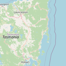
Why Freycinet National Park stands out

Freycinet National Park is most celebrated for its iconic coastal scenery, particularly Wineglass Bay, which consistently ranks among the world's most beautiful beaches. The park's defining visual feature is The Hazards, a dramatic line of pink granite peaks that creates a striking backdrop to the turquoise waters of the Freycinet Peninsula. Beyond its visual appeal, the park is significant for its ecological diversity, protecting forty-nine Tasmania-endemic species within a landscape that ranges from coastal dunes and heaths to dry sclerophyll forests. The park is also notable for its conservation challenges, particularly the impact of devil facial tumour disease on the Tasmanian devil population, which has prompted ongoing research and management interventions.

Freycinet National Park history and protected-area timeline

Freycinet National Park was established in 1916, making it one of the earliest protected areas in Tasmania and the oldest national park in the state alongside Mount Field National Park. The park was formally named after Louis de Freycinet, the French navigator who led an expedition that charted this section of the Tasmanian coast in 1802 aboard the vessel Naturaliste. The creation of the park reflected a growing recognition in the early twentieth century of the need to preserve Tasmania's unique natural heritage. Initially, protection focused on the most scenic and botanically significant areas, with the Freycinet Peninsula selected for its outstanding natural values and distinctive landscape character. Throughout the twentieth century, the park's boundaries were refined and expanded, and management practices evolved from early multiple-use approaches toward the contemporary focus on conservation and ecological management. The park's cultural heritage encompasses both Aboriginal sites and European historical features, though research into the human history of the area continues to reveal additional understanding of past land use and occupation.

Freycinet National Park landscape and geographic character

The landscape of Freycinet National Park is defined by its dramatic granite landforms that create one of Tasmania's most visually striking coastal environments. The dominant geological feature is the Freycinet Peninsula, composed primarily of Devonian granite that was formed deep within the Earth's crust approximately 400 million years ago. The granite contains significant amounts of orthoclase feldspar, which imparts the characteristic pink and warm reddish-brown coloration that distinguishes The Hazards and other peaks throughout the park. These granite formations have been shaped by millions of years of weathering and erosion, producing the steep cliffs, rounded summits, and rugged coastal scenery that define the area. The western side of Schouten Island presents a different geological character, composed of Jurassic dolerite that forms more angular, darker rock formations. Between the mountain ridges, the park contains numerous valleys, lagoons, and wetlands, including Hazards Lagoon, which supports distinctive vegetation communities. The coastline features diverse landforms including sandy beaches such as Wineglass Bay and Hazards Beach, rocky headlands, coastal dunes, and offshore islands. The interior of the peninsula supports undulating terrain covered by forest and woodland, with elevation ranging from sea level to approximately 620 metres at Mount Graham and other prominent peaks.

Freycinet National Park ecosystems, habitats, and plant life

The ecological character of Freycinet National Park reflects the transitional position of the Freycinet Peninsula between Tasmania's wetter western forests and the drier eastern environments. The park is dominated by dry sclerophyll forests and woodlands, with black peppermint eucalypt forming the primary tree canopy over a diverse understorey of heaths and shrubs. Plant families including Banksia, Leptospermum, Thryptomene, Melaleuca, and Calytrix are well represented in the heathland communities, particularly around Hazards Lagoon. The park supports an extraordinary botanical diversity, with over 500 plant species recorded, including more than 80 orchid species. Several plant species have very restricted distributions within the park, and numerous species are listed as threatened under the Tasmanian Threatened Species Protection Act. Notable among these are Melaleuca pustulata, Cyphanthera tasmanica, Epacris barbata, and Westringia brevifolia var. raleighi. The park also contains the sand grass tree, which is endemic to Tasmania and listed as vulnerable at both state and national levels, with populations occurring in suitable habitat areas within the reserve.

Freycinet National Park wildlife and species highlights

Freycinet National Park supports remarkable faunal diversity, with forty-nine species endemic to Tasmania recorded within its boundaries. The mammal community includes several common species that visitors may encounter, most notably the red-necked wallaby, also known as Bennett's wallaby, which is frequently observed grazing in open areas. The park supports populations of eastern quoll, a marsupial carnivore now extinct on the Australian mainland and found only in Tasmania. The Tasmanian pademelon remains common in the park but is primarily nocturnal, making sightings less frequent. The park also hosts the echidna, which can be found foraging in forests and coastal areas, along with various possum species including the eastern pygmy possum and little pygmy possum. The reptile fauna includes several endemic species such as the ocellated skink, Tasmanian tree skink, and she-oak skink, along with the blotched blue-tongued lizard and mountain dragon. The amphibian community includes the endemic Tasmanian froglet and the common eastern froglet. Marine environments support cetaceans including southern right whales and humpback whales that use Wineglass Bay for feeding and calving, while bottlenose dolphins are regularly observed in the bay. The birdlife is particularly diverse, with species ranging from large raptors including the white-bellied sea eagle and brown falcon to smaller birds such as the superb fairy-wren and flame robin. Several bird species are listed as threatened, including the swift parrot, which breeds on the east coast of Tasmania within the park's forests.

Freycinet National Park conservation status and protection priorities

Freycinet National Park plays a critical role in conserving Tasmania's unique biodiversity and geological heritage. The park protects significant populations of species that occur nowhere else on Earth, with forty-nine Tasmania-endemic species recorded within its boundaries. Several plant species of conservation concern are protected within the park, including the Freycinet Waxflower, which occurs only on the Freycinet Peninsula and is listed as endangered under both Commonwealth and Tasmanian legislation. The park's conservation value is enhanced by the relatively intact state of its native vegetation, with approximately 80-90 percent of native vegetation remaining in good condition across the bioregion. However, the park faces significant conservation challenges. The Tasmanian devil population has been severely impacted by devil facial tumour disease, a transmissible cancer that has caused a dramatic decline in numbers and led to the species being listed as endangered in 2008. This decline has potential cascading effects on other species, as devils play an important ecological role as apex predators. The park also faces threats from the soil-borne pathogen Phytophthora cinnamomi, which affects numerous plant species and can cause local extinctions of susceptible species. Feral animals, particularly cats, pose a threat to native mammals, and invasive weeds can be introduced by visitors. Management efforts focus on monitoring threatened species, controlling pathogens, managing visitor impacts, and implementing fire management strategies that consider the specific requirements of threatened plant species.

Freycinet National Park cultural meaning and human context

Freycinet National Park holds cultural significance for both Aboriginal communities and European settlers. The park contains numerous Aboriginal heritage sites, though the full extent of human occupation and use of the Freycinet Peninsula remains an area requiring further research. European history is tied to the French exploration expeditions of the early nineteenth century, with Louis de Freycinet naming the peninsula after himself following his 1802 voyage aboard the Naturaliste. The landscape also reflects more recent human activity, with historical land use patterns influencing vegetation patterns in some areas. The park's proximity to Coles Bay, a small coastal settlement, creates a relationship between the protected area and the local community, with tourism and visitor services forming an important part of the regional economy.

Top sights and standout views in Freycinet National Park

The most celebrated feature of Freycinet National Park is Wineglass Bay, a pristine crescent of white sand and turquoise water that consistently appears on lists of the world's most beautiful beaches, accessible via a walking track that offers panoramic views from the saddle. The Hazards present the park's most iconic mountain landscape, a dramatic line of pink granite peaks that rise sharply from the coast, providing excellent hiking opportunities and photogenic viewpoints. The park's botanical diversity, with over 500 plant species including more than 80 orchids, offers exceptional wildflower viewing opportunities, particularly in spring and early summer. The marine environment supports regular sightings of whales and dolphins, with southern right whales and humpback whales known to use Wineglass Bay for feeding and calving. The park's status as Tasmania's oldest national park, established in 1916, adds historical significance to the natural values, creating a legacy of conservation that continues today.

Best time to visit Freycinet National Park

Freycinet National Park can be visited year-round, though the warmer months from October through April offer the most comfortable conditions for walking and outdoor activities, with average daily maximum temperatures ranging from 16 to 23 degrees Celsius. The park enjoys a climate similar to Southern France, with more than 300 days of sunshine annually and approximately 600 millimetres of rainfall per year. Summer months bring the highest visitor numbers, particularly around Christmas and the January school holidays, so those seeking a more tranquil experience may prefer late autumn or winter. The winter months, while cooler, offer the opportunity to see migrating whales and experience the park's moods without the crowds. Spring brings exceptional wildflower displays as the heathlands and forests burst into bloom, with orchid season peaking from late winter through early summer. The shoulder seasons of autumn and early winter often provide excellent conditions for walking, with cooler temperatures making longer hikes more comfortable and the landscape displaying distinctive seasonal colours.

Park location guide

Geography guide, regional context, and park location map for Freycinet National Park

Freycinet National Park park geography, regions, and map view in Australia
Understand where Freycinet National Park sits in Australia through a broader geographic reading of the surrounding landscape, nearby location context, and its mapped position within the national park landscape.

How Freycinet National Park fits into Australia

Australia is a constitutional monarchy and federal parliamentary democracy comprising six states and ten territories. With a population of nearly 28 million, it is one of the world's most urbanised countries, with most people concentrated on the eastern seaboard. The country has a high Human Development Index and is known for its cultural diversity, ancient Aboriginal heritage, and unique wildlife.

Wider geography shaping Freycinet National Park in Australia

Australia occupies the entire Australian continent, the island of Tasmania, and numerous smaller islands. It is the world's flattest and driest inhabited continent, featuring vast deserts in the interior (the Outback), tropical rainforests along the eastern coast, and a coastline bordering the Indian and Pacific Oceans.

Map view of Freycinet National Park

Use this park location map to pinpoint Freycinet National Park in Australia, understand its exact geographic position, and read its mapped placement within the surrounding landscape more clearly.

Pigeon | © OpenStreetMap contributors

Location context for Freycinet National Park

Tasmania
Park atlas

Browse adjacent protected areas and compare the regional park geography of Tasmania's east coast.

Discover Nearby National Parks and Protected Landscapes Around Freycinet National Park
After exploring Freycinet National Park, browse other significant protected areas and national parks located within the broader regional geography, tracing the patterns of coastal protection and unique Tasmanian landscapes. This comparison offers valuable atlas context, allowing users to map the spread of conservation efforts and understand the diverse terrain of surrounding protected landscapes.
National parkTasmania

Walls of Jerusalem National Park: A Mapped Alpine Wilderness in Tasmania

Explore protected landscapes with biblical place names.

Walls of Jerusalem National Park in Tasmania is a distinguished national park characterized by its rugged alpine terrain and dramatic quartzite formations, most notably King Davids Peak. The park's landscape is further distinguished by a unique series of features named after biblical locations, offering an evocative exploration for those interested in geographic discovery. As a protected wilderness area within the Tasmanian Wilderness World Heritage Area, it provides valuable insight into Australia's significant natural landscapes and their mapped representation.

Area
518 km²
Established
1978
IUCN
II
National parkTasmania

Narawntapu National Park: Tasmania's Coastal Protected Landscape and Wildlife Atlas

Explore mapped boundaries, heathland, woodland, and intertidal bird habitats.

Narawntapu National Park showcases a remarkable protected coastal landscape on Tasmania's north coast, renowned for its exceptional density of marsupial wildlife and significant intertidal bird populations. Its diverse terrain, including heathland, woodland, and extensive mudflats, offers unique opportunities for geographic discovery and understanding the park's ecological importance. Examine its mapped natural features and protected status within the broader atlas of Australian reserves.

Area
43.49 km²
Established
1976
IUCN
II
National parkTasmania

Southwest National Park: Tasmania's Core Wilderness National Park and World Heritage Landscape

Mapping the remote buttongrass moorlands and rugged terrain of this expansive park.

Southwest National Park represents a significant protected area in Tasmania, Australia, spanning over 6,183 square kilometers. As the heart of the Tasmanian Wilderness World Heritage Area, it showcases an extraordinary landscape characterized by vast buttongrass moorlands, ancient temperate rainforests, and dramatic mountainous terrain. This park is vital for its wilderness character and conservation significance, offering a unique opportunity to explore one of the Southern Hemisphere's last remaining untouched temperate wildernesses through its mapped geography and protected boundaries.

Area
6,182.67 km²
Established
1968
IUCN
II
National parkTasmania

Cradle Mountain, Lake St Clair National Park: Tasmania's Mapped Protected Landscape and Geography

Explore national park boundaries and regional natural terrain.

Gain insight into Cradle Mountain, Lake St Clair National Park, a protected national park in Tasmania, Australia. This entry provides a foundational understanding of its mapped terrain, geographic setting, and protected area status. Delve into the specific landscape characteristics that define this significant conservation zone and its place within the national atlas.

Area
1,614.43 km²
Established
1922
IUCN
II
National parkTasmania

Rocky Cape National Park: Tasmania's Coastal National Park with Ancient Aboriginal Heritage

Explore the dramatic headland, heath ecosystems, and mapped park boundaries.

Rocky Cape National Park on Tasmania's North West Coast is a nationally significant protected area recognized for its ancient Aboriginal archaeological heritage, representing at least 8,000 years of continuous occupation. The park's landscape unfolds across a dramatic coastal headland, featuring rugged rocky shores, expansive heathlands, and coastal woodlands that define this wild section of Tasmania. Its protected status underscores its importance for both cultural discovery and the preservation of unique Australian coastal ecosystems. Understanding Rocky Cape National Park offers direct insight into the region's geography and the enduring legacy of its first peoples.

Area
30.64 km²
Established
1967
IUCN
II
Marine protected areaVictoria

Corner Inlet Marine National Park: Victoria Marine Protected Area Exploration

Mapped marine landscape and protected wetland discovery in South Gippsland.

Corner Inlet Marine National Park offers a distinct focus on protected marine environments and coastal wetland geography. As a significant marine protected area in Victoria, it showcases the ecological dynamics of a Ramsar-listed inlet, featuring extensive seagrass beds and intertidal habitats. This park provides essential context for understanding Victoria's network of protected marine landscapes and their interconnectedness with adjacent conservation areas.

Area
15.5 km²
Established
2002
IUCN
II
National parkVictoria

Tarra-Bulga National Park: Victoria's Remnant Temperate Rainforest Protected Landscape

Explore its mapped terrain and unique geographic setting.

Tarra-Bulga National Park offers a glimpse into Victoria's past with its exceptionally preserved temperate rainforest and towering mountain ash forests. Situated in the Strzelecki Ranges, this protected area is critical for understanding regional biodiversity and landscape evolution. Explore the mapped terrain, deep valleys, and fern-filled gullies that define its unique geographic character and protected status.

Area
15.22 km²
Established
1986
IUCN
II
National parkVictoria

Morwell National Park: Victoria's Protected Wet Sclerophyll Forest and Rainforest

Mapping the diverse flora and fauna of this key national park.

Morwell National Park is a protected national park in Victoria, Australia, renowned for its significant plant diversity and the preservation of wet sclerophyll forests alongside cool temperate rainforest pockets in its gullies. Located within the Strzelecki Ranges, the park's mapped geography illustrates the varied terrain supporting these distinct forest communities. As a conservation area driven by community advocacy, it stands as a vital reserve for regional biodiversity, offering a focused study of Victoria's unique protected landscapes and their ecological significance.

Area
5.65 km²
Established
1966
IUCN
III

Common questions about visiting, size, designation, and location context for Freycinet National Park

Freycinet National Park FAQs for park facts, access, geography, and protected area context
Find quick answers about Freycinet National Park, including protected-area facts, park geography, trail and visitor context, and how the park fits into its surrounding country and regional landscape.
MoriAtlas Explorer

Continue Your Protected Areas Search Across the Global Atlas

Deepen your exploration by continuing the structured search for national parks and protected areas worldwide. Utilize the comprehensive filtering capabilities to compare different conservation landscapes and refine your understanding of global park geography. Discover more about the distribution and characteristics of protected natural areas.

Global natural geography