
Why Khao Laem Ya, Mu Ko Samet National Park stands out
Khao Laem Ya, Mu Ko Samet is best known for its combination of accessible island recreation and marine conservation. Ko Samet, the park's largest island, has long been a popular beach destination for Thai and international visitors seeking tropical island scenery without extensive travel from Bangkok. The surrounding waters contain coral reef systems supporting diverse marine life including various coral species, sea turtles, and tropical fish. The park also preserves mainland granite hill formations like Khao Laem Ya and Khao Plet, along with the 11-kilometer Mae Rampeung Beach. The contrast between developed beach tourism on Ko Samet and the park's conservation mandate creates a distinctive management challenge that has drawn attention to issues of illegal construction and corruption within Thailand's national park system.
Khao Laem Ya, Mu Ko Samet National Park history and protected-area timeline
Khao Laem Ya–Mu Ko Samet National Park was established in 1981 when the Royal Forest Department declared the archipelago of Ko Samet, along with nine surrounding islands, the headland of Khao Laem Ya, and the Mae Rampeung Beach area as a national park. This designation brought these coastal and island areas under the formal jurisdiction of Thailand's national parks department, providing legal protection against uncontrolled development. The park's history has included significant enforcement challenges. In August 2013, more than 500 national park officials were deployed to destroy three resorts—Muk Samet, Unseen, and Ploy Samet—that had been constructed illegally within the park boundaries, demonstrating the ongoing tension between development pressures and conservation protection. A more systemic challenge emerged in September 2016 when the park chief and 79 other officials were removed from their positions due to corruption. Investigations revealed that businesses on Ko Samet valued at over 100 million baht per month were being operated by organized crime groups, some with connections to police officers. Monthly kickbacks of approximately 200,000 baht were being paid to park officials. Following the removal of corrupt personnel, park revenues increased substantially, rising to 4.8 million baht in October 2016 from 1.2 million baht in October 2015, indicating both the scale of illegal activity and the potential for improved management.
Khao Laem Ya, Mu Ko Samet National Park landscape and geographic character
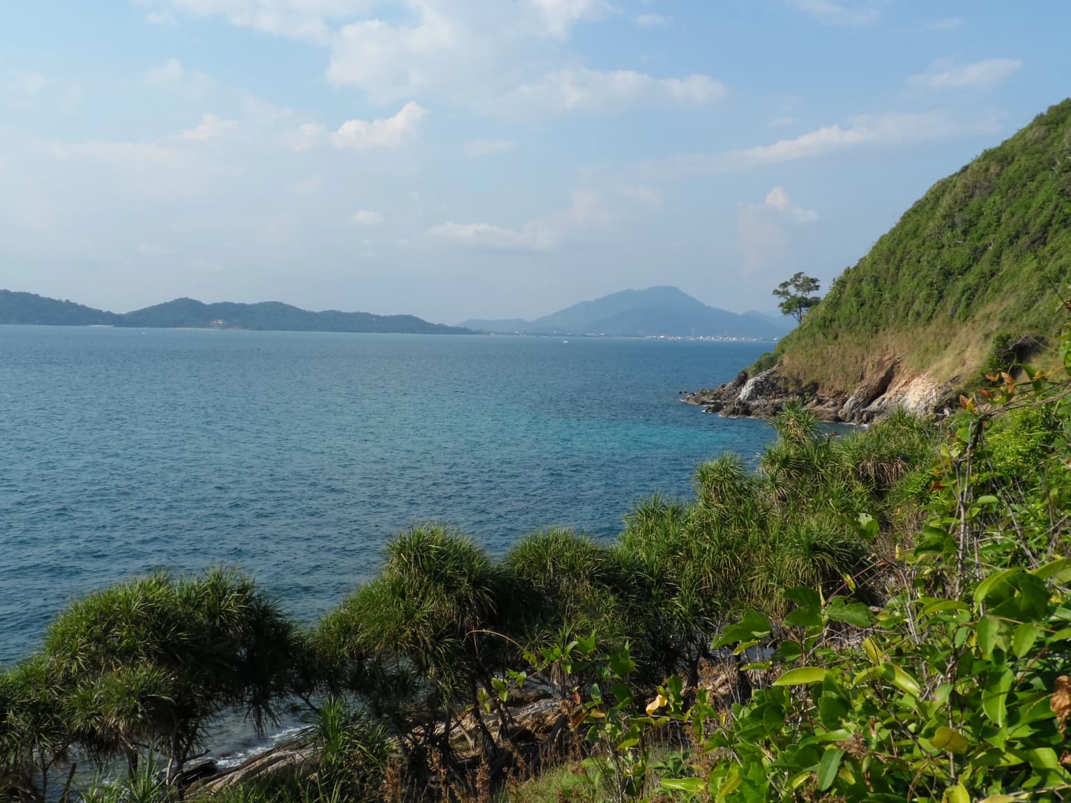
The park's landscape encompasses both mainland coastal features and an archipelago of islands in the Gulf of Thailand. The mainland portion includes the headland of Khao Laem Ya, characterized by granite hill formations rising to approximately 108 meters above sea level, along with adjacent valleys and the extensive Mae Rampeung Beach stretching roughly 11 kilometers along the coast. The park's islands vary considerably in size and character. Ko Samet, the largest and most visited, features a landscape of low mountains and hills including Khao Charoen, Khao Ploi Wan, and Khao Phra Chedi. The western side of Ko Samet has steep slopes while the eastern side is gentler, featuring a continuous sandy beach along much of its eastern coastline. The island reaches approximately 2,500 meters in width at its northern end and extends about 6,500 meters in length. Beyond Ko Samet, the park includes smaller islands such as Ko Kudi, Ko Kruai, Ko Makham, Ko Plai Tin, Ko Chan, Ko Talu, Ko Klet Chalam, and Ko Thai Khang Kao, each contributing to the archipelago's diverse coastal scenery. The marine portion encompasses shallow tidal areas, reef zones, and deeper Gulf waters, with marine environments comprising approximately 94 percent of the total park area.
Khao Laem Ya, Mu Ko Samet National Park ecosystems, habitats, and plant life
Khao Laem Ya–Mu Ko Samet supports several distinct vegetation communities shaped by the coastal and island environment. Dry evergreen forest covers much of the hilly areas both on the mainland and throughout the islands, particularly around Khao Laem Ya, Khao Plet, and Khao Tien on the mainland, with more scattered distribution on the islands. This forest type features species adapted to seasonal dry conditions. Beach forest occurs along shoreline areas where sandy soils and salt exposure create specialized growing conditions, with vegetation adapted to coastal exposure and periodic tidal flooding. The park's marine environments are characterized by coral reef systems concentrated around Ko Samet, the Ko Kudi island group, and Ko Talu. The most thriving reef areas are found at Hin Kanna, Hin Ao Phrai, Ao Lek, Ao Klua Nai, Ko Chan, Ko Plai Tin, Ko Kudi, and Ko Talu, where coral formations support diverse reef communities. The waters around the islands contain various coral types including branching corals, brain corals, plate corals, and soft corals.
Khao Laem Ya, Mu Ko Samet National Park wildlife and species highlights
The park supports notable wildlife diversity across both terrestrial and marine environments. Terrestrial mammals in the park include crab-eating macaques, lesser mouse-deer, and flying foxes. The island environments provide habitat for various bird species, with seabirds such as Pacific reef heron, black-naped tern, bridled tern, great crested tern, and roseate tern nesting on island shores. Other bird species found in the park include blue-winged pitta, zebra dove, coppersmith barbet, and Asian barred owlet. Marine fish species around the islands include parrot fish and blue damselfish, with cuttlefish also present in the waters. At least 144 vertebrate species have been recorded within the park according to Thai language source material. The underwater environments support marine reptiles including sea turtles, while coral reefs host diverse invertebrate and fish communities typical of Gulf of Thailand marine ecosystems.
Khao Laem Ya, Mu Ko Samet National Park conservation status and protection priorities
As a Category II protected area under the IUCN classification system, Khao Laem Ya–Mu Ko Samet serves significant conservation functions for both coastal and marine environments. The park protects coral reef systems that represent important marine biodiversity hotspots in the Gulf of Thailand. These reef ecosystems provide habitat for numerous marine species and contribute to overall marine ecological health in the region. The terrestrial components, though limited in extent, preserve examples of dry evergreen forest and beach forest communities that have faced conversion pressure in the populated coastal zone of eastern Thailand. The park's management challenges illustrate the difficulties of protecting coastal areas that also serve as tourism destinations, with illegal construction requiring enforcement action in 2013 and corruption issues among park management staff surfacing in 2016. These incidents highlight the ongoing tensions between development pressures and conservation goals in Thailand's protected areas.
Khao Laem Ya, Mu Ko Samet National Park cultural meaning and human context
The park exists within a region of active coastal communities and tourism development. Ko Samet has a long history as a local fishing and coastal community area, with residential areas historically concentrated along the northern and eastern shorelines where lower slopes and coastal plains provided suitable settlement locations. The park encompasses areas where local communities maintain connections to the marine environment. The relationship between park protection and traditional land use, as well as more recent tourism development, represents a recurring theme in the park's management context. The enforcement actions against illegal resort construction reflect ongoing negotiations between conservation priorities and economic development pressures in Thailand's coastal zones.
Top sights and standout views in Khao Laem Ya, Mu Ko Samet National Park
Khao Laem Ya–Mu Ko Samet combines accessibility from Bangkok with natural conservation value, making it one of Thailand's most visited coastal parks. The park's multiple islands, each with distinctive shapes and beach configurations, offer varied coastal experiences. Coral reef areas around several islands provide snorkeling and diving opportunities in the Gulf of Thailand's marine environment. The contrast between Ko Samet's developed tourism infrastructure and the protected status of surrounding waters and smaller islands creates a unique management landscape. The 11-kilometer Mae Rampeung Beach on the mainland provides additional coastal recreation opportunities within the park boundaries. The granite hills like Khao Laem Ya offer views over the Gulf and can be accessed as part of the park experience.
Best time to visit Khao Laem Ya, Mu Ko Samet National Park
The park can be visited year-round, though the optimal period considers Thailand's tropical climate patterns. The monsoon season from May to September brings stronger winds and waves, with rough seas potentially preventing boat travel to the outer islands on some days; approximately 15 days per month during this period may see conditions too rough for water transport. The coolest and driest period from November to March offers more stable conditions but can still experience occasional monsoon winds and rainfall that may limit boat access. Average temperatures hover around 29 degrees Celsius, with the hottest period from March to June. The timing of visits should account for both weather conditions and the park's high visitor numbers, as weekends and holidays see substantial crowds, particularly on Ko Samet.