Mori Atlas logo
National parkKudremukh National Park

Discover the unique geography, biodiversity, and watershed significance of this key Indian national park.

Kudremukh National Park: A Vital Protected Landscape in Karnataka's Western Ghats

Kudremukh National Park represents a significant protected area within Karnataka, India, celebrated for its exceptional biodiversity and critical role as a watershed for major rivers. This national park, spanning extensive tracts of the Western Ghats, showcases a distinctive landscape mosaic of montane grasslands interspersed with unique shola forests. Its geographic importance is underscored by its designation as a biodiversity hotspot and a vital habitat, offering a profound glimpse into regional natural heritage and conservation value.

Western GhatsNational ParkBiodiversity HotspotTropical RainforestLion-tailed MacaqueWildlife Conservation

Kudremukh National Park

National park

Park overview

Structured park overview, official facts, and landscape profile for Kudremukh National Park

Kudremukh National Park park facts, protected area profile, and essential visitor context
Review the core facts for Kudremukh National Park, including designation, size, terrain, visitor scale, habitats, and operating context in one park-focused overview.

About Kudremukh National Park

Kudremukh National Park occupies a significant position in India's conservation landscape as the largest protected area of tropical wet evergreen forest in the Western Ghats. Located in the Chikmagalur and Dakshina Kannada districts of Karnataka state, the park spans latitudinal and longitudinal ranges that encompass diverse ecological zones. The Western Ghats, recognized globally as one of the twenty-five biodiversity hotspots, provides the setting for this protected area, which was established in 1987 after decades of advocacy by conservationists including Dr. Ullas Karanth, whose detailed surveys of the lion-tailed macaque population helped establish the case for formal protection. The park's name, meaning horse-face in the local language, refers to the distinctive profile of the Kudremukh peak, a visual landmark that gives the area its character and identity. The region has historically been known for its iron ore mining activities, with the Kudremukh Iron Ore Company Limited operating in the area for over two decades before environmental concerns led to its closure. Today, the park represents a critical conservation zone where multiple large mammal predator species coexist, and where the protection of watershed areas carries immense significance for downstream agricultural communities.

Quick facts and research context for Kudremukh National Park

Kudremukh National Park occupies 600.57 square kilometers in the Western Ghats mountain range of Karnataka, India, spanning Chikmagalur and Dakshina Kannada districts. The elevation ranges from 100 meters to 1,892 meters at the Kudremukh peak. The area receives approximately 7,000 millimeters of annual rainfall, supporting diverse forest types including tropical wet evergreen, semi-evergreen, and shola grasslands. The park is part of the Western Ghats biodiversity hotspot and is designated as IUCN Category II (National Park). It serves as the source catchment for three major river systems that provide water to Karnataka and Andhra Pradesh.

Park context

Deeper park guide and search-rich context for Kudremukh National Park

Kudremukh National Park history, landscape, wildlife, and travel context
Explore Kudremukh National Park through its history, landscape character, ecosystems, wildlife, conservation priorities, cultural context, and seasonal travel timing in a structured park guide built for atlas discovery and search intent.

Why Kudremukh National Park stands out

Kudremukh National Park is best known for its exceptional biodiversity and the presence of the endangered lion-tailed macaque, one of the rarest primates in India. The park's shola forest ecosystem, a unique arrangement of montane grasslands interspersed with evergreen forest, supports a remarkable concentration of large mammals including tigers, leopards, wild dogs, gaur, and sambar deer. The landscape is dominated by the distinctive Kudremukh peak with its horse-face appearance, and the park contains important watershed areas feeding three major rivers. The region is also notable for its history of iron ore mining and subsequent conservation efforts that led to the closure of the Kudremukh Iron Ore Company Limited.

white tiger
white tiger

Kudremukh National Park history and protected-area timeline

The conservation history of Kudremukh traces to 1916 when the British Government declared the region a Reserved Forest, seeking to prevent the spread of slash-and-burn cultivation practices into the Western Ghats. The modern conservation movement gained momentum in the early 1980s when renowned environmentalist and tiger expert Dr. Ullas Karanth conducted comprehensive surveys of lion-tailed macaque populations in Karnataka between 1983 and 1984. His research revealed that Kudremukh harbored the largest contiguous population of lion-tailed macaques in the Western Ghats outside the Malabar Coast region. Based on his findings and recommendations, the Karnataka State Wildlife Advisory Board proposed the creation of Kudremukh National Park. The first notification was issued, and in 1987 the Government of Karnataka formally declared the Reserved Forests as a National Park. The park's establishment followed prolonged efforts to address mining impacts in the region, with conservationists raising concerns about habitat fragmentation and water pollution from the Kudremukh Iron Ore Company Limited operations that had continued for over twenty years.

Kudremukh National Park landscape and geographic character

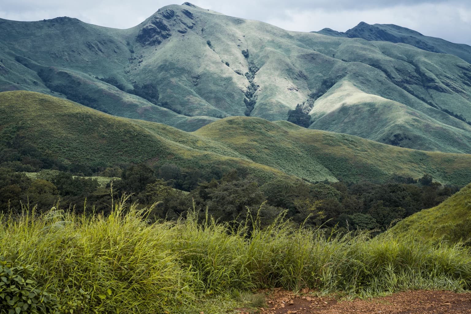
The physical landscape of Kudremukh National Park presents a dramatic contrast between the steep western slopes and the gentler rolling hills of the eastern portions. The park adjoins the Someshwara Wildlife Sanctuary to the west and connects to the Pushpagiri Wildlife Sanctuary through a narrow corridor of reserved forest on its southern edge. Elevations range from 100 meters in the lower reaches to 1,892 meters at the Kudremukh peak, creating distinct ecological zones across the park. The northern, central, and eastern areas feature a characteristic mosaic of natural grassland and shola forest, while the southern and western sides drop away sharply along the Western Ghat ridge line. The extraordinary rainfall of approximately 7,000 millimeters annually has shaped the landscape, generating thousands of perennial streams that converge to form the Tunga, Bhadra, and Nethravathi rivers. Notable scenic attractions include the Hanumana Gundi waterfalls, where water cascades over natural rock formations from a height exceeding 30 meters, and the Kadambi waterfall area.

Kudremukh national park.jpg
Panoramic view of Kudremukh National Park.

Kudremukh National Park ecosystems, habitats, and plant life

The ecological character of Kudremukh National Park is defined by its position within the Western Ghats biodiversity hotspot and its remarkable diversity of forest types. The high annual rainfall has resulted in predominantly evergreen or semi-evergreen climax forests across most of the park's extent. The shola grassland ecosystem, comprising montane grasslands interspersed with stunted evergreen forest in the valley depressions, represents a particularly distinctive habitat type found at higher elevations. These forests possess extraordinary water-retentive capacity, functioning as natural sponges that release water gradually through countless streams. The park supports three major river systems that form vital lifelines for agricultural communities in Karnataka and Andhra Pradesh. The combination of steep terrain, heavy rainfall, and diverse forest types has created conditions supporting exceptional biodiversity, with the park considered one of the most ecologically significant protected areas in peninsular India.

Kudremukh
Kudremukh, Karnataka

Kudremukh National Park wildlife and species highlights

Kudremukh National Park supports an impressive assembly of large mammals, including three major predator species: tigers, leopards, and wild dogs (dholes). The prey base includes gaur, sambar deer, wild pig, muntjac, chevrotain, bonnet macaque, common langur, and the critically significant lion-tailed macaque. The park is particularly important for lion-tailed macaque conservation, as Dr. Ullas Karanth's surveys identified this area as supporting the largest contiguous population of this endangered primate in the Western Ghats. Other notable species include the sloth bear, spotted deer, and the rare malabar civet. The diverse habitats support rich birdlife and numerous smaller mammal species, though dense forest cover can make wildlife observation challenging for visitors. The drive through the forest ranges offers opportunities to spot various species, particularly during dawn and dusk when animals are more active near the roads.

Hanumanagundi Falls
Hanumana Gundi Falls, Kudremukh National Park, Karnataka.

Kudremukh National Park conservation status and protection priorities

The conservation significance of Kudremukh National Park extends beyond its boundaries as a critical watershed and biodiversity repository. The park falls within Global Tiger Conservation Priority-I classification, reflecting its importance for tiger habitat and population viability. The lion-tailed macaque population served as a flagship species for conservation planning, demonstrating how protecting a single endangered species can preserve entire biotic communities. The establishment of the park represented a response to significant environmental threats, particularly from iron ore mining operations that had caused habitat fragmentation and water pollution. The closure of the Kudremukh Iron Ore Company Limited marked an important victory for conservation, with estimates suggesting that over 1,000 square kilometers of agricultural land would have been jeopardized without protection of this sensitive watershed area. The park continues to face challenges related to its mining legacy and the need for ongoing habitat restoration.

Kudremukh National Park cultural meaning and human context

The Kudremukh region carries cultural significance beyond its ecological value, with the area historically known as a mining town centered around the Kudremukh Iron Ore Company Limited operations. The region features a temple dedicated to goddess Bhagavathi and a Varaha (boar) image located within a cave, representing significant local religious sites. The town of Kudremukh, situated approximately 48 kilometers from Karkala and 20 kilometers from Kalsa, was built along colonial lines and reflects the historical influence of British administration in the region. The interplay between conservation interests and mining development has shaped the community's identity, with the transition from an iron ore extraction center to a protected area creating new economic dynamics for local residents. The area's name and its visual association with a horse's face reflect the way local communities have connected their landscape to cultural symbolism.

Top sights and standout views in Kudremukh National Park

Kudremukh National Park offers visitors exceptional natural beauty through its mountain landscapes, waterfalls, and rich biodiversity. The Kudremukh peak itself, with its distinctive horse-face profile visible from certain angles, provides an iconic visual anchor for the park. Hanumana Gundi waterfalls, located 32 kilometers from Kalasa, offers a dramatic cascade falling over natural rock formations from heights exceeding 30 meters, accessible via trekking routes. The park's three major rivers, Tunga, Bhadra, and Nethravathi, originate from its slopes, highlighting the area's watershed significance. Wildlife enthusiasts may spot tigers, leopards, wild dogs, and the endangered lion-tailed macaque, though dense forest cover requires patience and luck. The contrast between rolling hills with shola grasslands and the steep western Ghat slopes creates varied scenery throughout the park.

Best time to visit Kudremukh National Park

The optimal period to visit Kudremukh National Park extends from October through May, when weather conditions are most favorable for exploration and wildlife viewing. The post-monsoon season from October to November offers lush green landscapes as the grasslands and forests remain refreshed from the heavy rains, while temperatures remain comfortable for trekking activities. The winter months from December through February provide clearer visibility and pleasant daytime temperatures, though mornings and evenings can be cool. The dry season from March to May offers better wildlife viewing opportunities as animals congregate more visibly around water sources, though the landscape may appear less verdant. The heavy monsoon season from June to September brings extremely high rainfall that can restrict access to certain areas and make wildlife observation difficult, though the transformed landscape with abundant waterfalls and flowing streams presents its own appeal for adventurous visitors.

Park location guide

Geography guide, regional context, and park location map for Kudremukh National Park

Kudremukh National Park park geography, regions, and map view in India
Understand where Kudremukh National Park sits in India through a broader geographic reading of the surrounding landscape, nearby location context, and its mapped position within the national park landscape.

How Kudremukh National Park fits into India

India is a South Asian country bordered by the Indian Ocean, Arabian Sea, and Bay of Bengal. It shares land borders with Pakistan, China, Nepal, Bhutan, Bangladesh, and Myanmar. The country has a population of over 1.4 billion people and operates as a federal parliamentary republic with its capital in New Delhi.

Wider geography shaping Kudremukh National Park in India

India occupies the Indian subcontinent in South Asia, bordered by the Arabian Sea to the southwest, the Bay of Bengal to the southeast, and the Indian Ocean to the south. It shares land borders with Pakistan to the west, China, Nepal, and Bhutan to the north, and Bangladesh and Myanmar to the east. The territory also includes the Andaman and Nicobar Islands in the Indian Ocean.

Map view of Kudremukh National Park

Use this park location map to pinpoint Kudremukh National Park in India, understand its exact geographic position, and read its mapped placement within the surrounding landscape more clearly.

Pigeon | © OpenStreetMap contributors

Location context for Kudremukh National Park

Karnataka

Visualizing Kudremukh's Western Ghats Terrain, Tropical Evergreen Habitats, and Iconic Horse-Face Peak

Kudremukh National Park Photos: Explore Diverse Landscapes, Shola Forests, and Mountain Scenery
Visually explore Kudremukh National Park through a curated gallery of its distinctive mountain landscapes, dense shola forests, and vital river origins within the Western Ghats. These images offer crucial insights into the park's diverse protected-area character, showcasing its unique blend of rolling grasslands, steep slopes, and rich biodiversity, essential for understanding this Indian conservation gem.

white tiger

Kudremukh Shola Grasslands and Forest Ecosystem

Kudremukh national park.jpg

Kudremukh

Hanumanagundi Falls

Park atlas

Compare diverse national parks and protected areas, exploring their geographic context near Kudremukh National Park.

Explore Nearby National Parks and Protected Areas Around Kudremukh National Park
After exploring Kudremukh National Park, browse other significant national parks and protected areas across the Western Ghats, an essential biodiversity hotspot in India. Compare these regional landscapes to understand their conservation priorities, distinct ecosystems, and geographic spread within this vital ecological corridor.
National parkKarnataka

Bandipur National Park: Karnataka's Protected Landscape and National Park Atlas Entry

Discover mapped terrain and diverse forest ecosystems in South India.

Bandipur National Park, a prominent national park within Karnataka, serves as a vital hub for understanding protected area geography and landscape diversity. Its ecological significance is amplified by its location at the intersection of the Deccan Plateau and the Western Ghats, supporting a unique blend of forest types and rich biodiversity. This entry provides essential context for atlas-based discovery, detailing the park's mapped terrain, its role as a tiger reserve, and its contribution to the Nilgiri Biosphere Reserve's conservation landscape.

Area
1,456.3 km²
Established
1973
IUCN
II
National parkNilgiri District

Mukurthi National Park: Nilgiri District's Protected Montane Grassland and Shola Ecosystem

Explore a vital refuge for the endangered Nilgiri tahr.

Mukurthi National Park, situated in the Nilgiri District of India, is an essential protected area celebrated for its distinctive montane landscape. This national park plays a critical role in the survival of the endangered Nilgiri tahr, protecting the rare shola-grassland ecosystem where they thrive. Its dramatic terrain, high elevations, and unique ecological associations make it a focal point for understanding conservation geography and the mapped boundaries of protected lands within the Western Ghats.

Area
78.46 km²
Established
1990
IUCN
II
Relief
Mountain
National parkKerala

Periyar National Park: National Park Protected Area Atlas and Geographic Context

Mapped protected lands and regional landscape exploration in Kerala.

Discover Periyar National Park as a distinct protected landscape offering rich geographic context for atlas exploration. This entry details its mapped boundaries and its significance within the broader regional geography of Kerala. Understand the natural terrain and protected-area distribution that makes Periyar National Park a key element in India's conservation mapping.

Area
350.54 km²
Established
1982
IUCN
II
Visitors
754.3K annual
National parkTelangana

Mrugavani National Park: Telangana's Protected Area within the Deccan Plateau's Natural Landscape

Explore undulating terrain and tropical dry forest ecosystems.

Mrugavani National Park represents a significant protected landscape within Telangana, India, characterized by its characteristic Deccan Plateau geography. Covering 1,211 acres, this national park features a terrain of rocky outcrops and undulating topography supporting a tropical dry deciduous forest ecosystem. It serves as a critical refuge for native flora and fauna, including a notable population of spotted deer, and offers a valuable case study in regional conservation and mapped protected areas near urban centers.

Area
4.9 km²
Established
1994
IUCN
II
Relief
Upland
National parkTamil Nadu

Gulf of Mannar Marine National Park: Protected Island Archipelago and Marine Atlas

Explore India's vital marine national park and its coral reef ecosystems.

Gulf of Mannar Marine National Park is a designated national park located in Tamil Nadu, India, protecting a chain of 21 islands and their surrounding marine environments. This protected area is renowned for its extensive coral reefs, crucial seagrass meadows supporting dugongs, and diverse fish species, making it a key site for marine conservation and geographic exploration. The park's unique island landscape and intertidal zones offer a distinct perspective on coastal protected areas within the Indian Ocean, providing rich material for atlas-style discovery and understanding regional marine geography.

Area
560 km²
Established
1986
IUCN
II
Relief
Lowland
National parkNorthern Province

Adam's Bridge Marine National Park: Protected Coastal Landscape and Geographic Significance

Mapped marine geography and protected island ecosystems.

Adam's Bridge Marine National Park is a protected national park in Sri Lanka's Northern Province, notable for encompassing the legendary Adam's Bridge. This marine protected area safeguards critical shallow-water habitats, including seagrass meadows and sand dunes, which are vital for migratory birds, dugongs, and sea turtles. The park's unique geographic identity as a chain of limestone shoals and islands offers a distinct landscape for atlas-based discovery and understanding of coastal conservation significance.

Area
190 km²
Established
2015
IUCN
II
National parkMaharashtra

Sanjay Gandhi National Park: Protected Forest Landscape and Ancient Buddhist Archaeology

Explore the mapped terrain and natural geography within Maharashtra.

Sanjay Gandhi National Park offers a unique blend of natural and historical discovery. This national park preserves vital tropical forest ecosystems characteristic of the Western Ghats region, providing a crucial urban wilderness habitat. Its most prominent feature is the Kanheri Caves, an extensive network of ancient rock-cut Buddhist structures showcasing over 2,400 years of continuous religious and cultural history. The park's protected boundaries encompass diverse terrain, supporting leopard populations and a rich variety of bird and insect life, all within the metropolitan limits of Mumbai, making it a significant site for geographic and conservation exploration.

Area
87 km²
Established
1996
IUCN
II
National parkNorthern Province

Madhu Road National Park: Sri Lanka's Northern Province Dry Zone National Park

Explore protected landscapes and mapped geography.

Madhu Road National Park, situated in Sri Lanka's Northern Province, is a significant protected area defined by its dry zone ecosystems, including forests, grasslands, and wetlands. As one of the island's larger national parks, it offers critical habitat for diverse wildlife and represents an important component of northern Sri Lanka's conservation efforts. This page provides detailed atlas-style insights into the park's geography, mapped boundaries, and its ecological context within the region.

Area
631 km²
Established
2015
IUCN
II

Common questions about visiting, size, designation, and location context for Kudremukh National Park

Kudremukh National Park FAQs for park facts, access, geography, and protected area context
Find quick answers about Kudremukh National Park, including protected-area facts, park geography, trail and visitor context, and how the park fits into its surrounding country and regional landscape.
MoriAtlas Explorer

Continue Your Protected Areas Search Across the Global Atlas

Deepen your exploration by continuing the structured search for national parks and protected areas worldwide. Utilize the comprehensive filtering capabilities to compare different conservation landscapes and refine your understanding of global park geography. Discover more about the distribution and characteristics of protected natural areas.

Global natural geography