Mori Atlas logo
National parkMrugavani National Park

Discover mapped boundaries, undulating terrain, and savanna-woodland ecosystems near Hyderabad.

Mrugavani National Park: Telangana's Protected Landscape and Regional Geography Atlas

Mrugavani National Park stands as a vital protected area within Telangana, showcasing the unique landscape character of the Deccan Plateau. This national park preserves a delicate tropical dry deciduous forest ecosystem, characterized by rocky outcrops and undulating topography, offering a crucial green sanctuary near the bustling metropolis of Hyderabad. Explore its mapped boundaries and diverse habitats, understanding its significance as a hub for regional wildlife and a focal point for understanding the protected natural geography of India.

National ParkTropical Dry Deciduous ForestTelanganaWildlife RefugeBirdwatchingSpotted Deer

Mrugavani National Park

National park

Park overview

Structured park overview, official facts, and landscape profile for Mrugavani National Park

Mrugavani National Park park facts, protected area profile, and essential visitor context
Review the core facts for Mrugavani National Park, including designation, size, terrain, visitor scale, habitats, and operating context in one park-focused overview.

About Mrugavani National Park

Mrugavani National Park represents an important conservation initiative in Telangana, established in 1994 to protect a tract of tropical dry deciduous forest ecosystem near the rapidly growing city of Hyderabad. Located in the Chilkur area of Moinabad mandal in Ranga Reddy district, the park covers 4.90 square kilometers of undulating terrain characterized by the rocky Deccan trap geological formations that underlie much of the Deccan Plateau. The vegetation of the park, while classified as southern tropical dry deciduous forest, exists in a degraded condition yet retains significant ecological value through its collection of native plant species. The park provides visitors with environmental education facilities including a library, museum, and auditorium, alongside opportunities for safari rides and guided nature walks. A watch tower offers elevated views across the landscape for wildlife observation. The park's location near the historic Chilkur Balaji Temple adds a cultural dimension to the natural setting, creating a composite destination that serves both conservation and educational purposes for the Hyderabad metropolitan region.

Quick facts and research context for Mrugavani National Park

Mrugavani National Park spans 1,211 acres in Telangana's Ranga Reddy district, established in 1994 near Hyderabad. The terrain features undulating rocky formations of the Deccan trap with a mosaic of woodland and grassland vegetation classified as southern tropical dry deciduous forest. The park supports over 600 plant species and approximately 350 spotted deer, alongside diverse mammals, reptiles, and more than 100 bird species. Climate patterns include summer temperatures reaching 40°C, winter lows around 10°C, and monsoon rainfall between 300 to 750 millimeters annually.

Park context

Deeper park guide and search-rich context for Mrugavani National Park

Mrugavani National Park history, landscape, wildlife, and travel context
Explore Mrugavani National Park through its history, landscape character, ecosystems, wildlife, conservation priorities, cultural context, and seasonal travel timing in a structured park guide built for atlas discovery and search intent.

Why Mrugavani National Park stands out

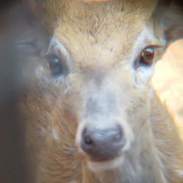
Mrugavani National Park is best known for its population of spotted deer (chital), which number around 350 individuals within the park boundaries. The reserve is also notable for its location as a protected green space near the major city of Hyderabad, serving both as an ecological sanctuary and an environmental education center. The park's diverse birdlife, with over 100 species including peacocks, warblers, and flowerpeckers, makes it significant for avian observation in the region. Additionally, the park preserves remnant tropical dry deciduous forest containing valuable species including teak, bamboo, and sandalwood, representing what the park management describes as the near-disappearing native flora of the Hyderabad region.

Mrugavani National Park history and protected-area timeline

Mrugavani National Park was declared as a national park in 1994, marking its formal designation as a Category II protected area under the International Union for Conservation of Nature's protected area classification system. The establishment of the park reflected growing recognition in India during the late twentieth century of the need to preserve remaining tracts of native forest ecosystem in rapidly urbanizing regions. The park was created specifically to conserve what officials described as the near-disappearing native flora of the Hyderabad region, acknowledging that urban expansion had significantly reduced the natural forest cover in the surrounding area. Since its designation, the park has developed visitor infrastructure including an education center, museum, auditorium, and safari facilities, positioning itself as both a wildlife sanctuary and an environmental learning resource for the regional population.

Mrugavani National Park landscape and geographic character

The landscape of Mrugavani National Park features the characteristic undulating terrain of the Deccan Plateau region, with rocky outcrops formed from the ancient Deccan trap basaltic rock formations. The park's topography supports three primary habitat types: woodland areas dominated by tree cover, open grasslands, and rocky exposures where vegetation is sparse. This mosaic of habitats creates visual and ecological diversity within the relatively compact park boundary. The terrain rises to a natural high point within the park that provides panoramic views across the surrounding landscape, a location that has been enhanced with a visitor watch tower for wildlife observation. The absence of significant water bodies or perennial streams within the park reflects its position within a drier tropical forest ecosystem where vegetation is adapted to seasonal moisture patterns rather than permanent aquatic environments.

Mrugavani National Park ecosystems, habitats, and plant life

The ecological character of Mrugavani National Park is defined by its classification as a southern tropical dry deciduous forest ecosystem, a vegetation type that has experienced significant reduction across its historical range due to agricultural conversion and urban development. The park contains over 600 documented plant species representing diverse botanical groups including trees, shrubs, herbs, climbers, bryophytes, and pteridophytes. Key tree species include teak, bamboo, sandalwood, and various Ficus species, while Palash (Butea monosperma) and Rela (likely a local species reference) contribute to the forest composition. The vegetation structure presents a mosaic of woodland patches and grassy clearings, reflecting both natural forest dynamics and historical degradation. This forest ecosystem serves as the foundation for the park's wildlife populations and represents a surviving fragment of the native vegetation that once covered larger portions of the Hyderabad region before extensive land-use change.

Mrugavani National Park wildlife and species highlights

Mrugavani National Park supports a diverse mammalian community headed by a population of approximately 350 spotted deer, known locally as chital, which represent the most visible large mammal species within the park. Sambar deer and wild boar are also present among the park's ungulate populations, while smaller mammals include jungle cats, civets, and Indian grey mongooses. The reptile fauna is particularly notable for its diversity and includes several significant species: the Indian python, Russell's viper, monitor lizard, rat snake, and the king cobra. The avian component of the park's wildlife is substantial, with more than 100 bird species documented including peacocks, various warblers, babblers, koels, lapwings, and flowerpeckers. This bird diversity, combined with the presence of the pied cuckoo and other species, establishes the park as an important birdwatching destination in the Hyderabad area.

Mrugavani National Park conservation status and protection priorities

Mrugavani National Park serves a critical conservation function as a protected refuge for the remaining native flora and fauna of the Hyderabad region, an area that has experienced substantial ecological transformation through urbanization and agricultural expansion. The park's explicit mission to conserve the near-disappearing native flora of the region reflects the broader challenge of preserving tropical dry deciduous forest ecosystems across their historical range in central India. By maintaining a protected area with diverse habitats including woodland, grassland, and rocky areas, the park preserves ecological processes and species populations that would otherwise face continued pressure from surrounding land-use. The presence of significant species including the spotted deer population and diverse avifauna demonstrates the conservation value of the protected area, while the education center and visitor programs support broader environmental awareness objectives.

Mrugavani National Park cultural meaning and human context

While primarily an ecological preserve, Mrugavani National Park benefits from proximity to the Chilkur Balaji Temple, a significant religious site located near the park's boundary. This spiritual landmark draws substantial visitor traffic to the area, creating potential for combined cultural and nature-based tourism experiences. The temple's presence near the park contributes to the historical and cultural identity of the Chilkur area and provides an additional reason for regional visitors to explore the park's surroundings. The park's development of education facilities including a museum and auditorium reflects broader intentions to connect visitors with environmental awareness, positioning the natural landscape within a context of cultural stewardship and ecological responsibility.

Top sights and standout views in Mrugavani National Park

The park's highlights center on its role as a accessible wilderness area near Hyderabad with strong conservation value for the region. The approximately 350 spotted deer represent the park's most iconic wildlife presence and provide reliable viewing opportunities for visitors. The diverse birdlife with over 100 species, including the conspicuous peacock, offers significant ornithological interest. The park's watch tower provides an elevated vantage point for landscape observation and wildlife watching, while the safari rides and guided nature walks allow visitors to experience the forest ecosystem more intimately. The environmental education facilities including the library, museum, and auditorium distinguish the park as a place for learning alongside wildlife observation. The undulating terrain with rocky outcrops adds visual interest to the landscape and supports the habitat diversity that underpins the park's ecological significance.

Best time to visit Mrugavani National Park

The park can be visited throughout the year, though the winter season from November to February offers the most comfortable conditions for outdoor exploration with temperatures ranging down to approximately 10°C. The pleasant winter climate makes this period particularly suitable for wildlife observation activities including nature walks and safari experiences. The summer months from March to May bring significantly higher temperatures that may limit comfortable outdoor activity, though early morning visits remain possible. The monsoon season from June to October brings rainfall that refreshes the landscape and supports lush vegetation growth, though heavy rains may affect visitor access and activities. The park's evergreen and deciduous plant communities provide visual interest across seasons, with different aspects of the ecosystem highlighted by seasonal changes in weather patterns.

Park location guide

Geography guide, regional context, and park location map for Mrugavani National Park

Mrugavani National Park park geography, regions, and map view in India
Understand where Mrugavani National Park sits in India through a broader geographic reading of the surrounding landscape, nearby location context, and its mapped position within the national park landscape.

How Mrugavani National Park fits into India

India is a South Asian country bordered by the Indian Ocean, Arabian Sea, and Bay of Bengal. It shares land borders with Pakistan, China, Nepal, Bhutan, Bangladesh, and Myanmar. The country has a population of over 1.4 billion people and operates as a federal parliamentary republic with its capital in New Delhi.

Wider geography shaping Mrugavani National Park in India

India occupies the Indian subcontinent in South Asia, bordered by the Arabian Sea to the southwest, the Bay of Bengal to the southeast, and the Indian Ocean to the south. It shares land borders with Pakistan to the west, China, Nepal, and Bhutan to the north, and Bangladesh and Myanmar to the east. The territory also includes the Andaman and Nicobar Islands in the Indian Ocean.

Map view of Mrugavani National Park

Use this park location map to pinpoint Mrugavani National Park in India, understand its exact geographic position, and read its mapped placement within the surrounding landscape more clearly.

Pigeon | © OpenStreetMap contributors

Location context for Mrugavani National Park

Telangana
Park atlas

Compare the distinct protected landscapes and regional park geography surrounding Mrugavani National Park.

Continue Your Discovery: Other Protected Areas Near Mrugavani National Park
After exploring Mrugavani National Park, browse other national parks and protected areas within the surrounding region of Telangana, India. This comparison reveals varied protected landscapes, different conservation focuses, and broader ecological context across the Deccan Plateau.
National parkKarnataka

Kudremukh National Park: Karnataka's Protected Landscape and River Origin

Explore the geography of shola forests and grasslands.

Kudremukh National Park is a pivotal protected landscape in Karnataka, India, recognized for its distinctive montane grasslands and shola forests. This national park is a critical source for three major rivers: the Tunga, Bhadra, and Nethravathi, highlighting its ecological and geographic significance within the Western Ghats. The park's terrain features rolling hills and steep western slopes, contributing to its unique biodiversity and landscape character for atlas-based discovery.

Area
600.57 km²
Established
1987
IUCN
II
Relief
Mountain
National parkMaharashtra

Sanjay Gandhi National Park: Protected Forest Landscape and Ancient Buddhist Archaeology

Explore the mapped terrain and natural geography within Maharashtra.

Sanjay Gandhi National Park offers a unique blend of natural and historical discovery. This national park preserves vital tropical forest ecosystems characteristic of the Western Ghats region, providing a crucial urban wilderness habitat. Its most prominent feature is the Kanheri Caves, an extensive network of ancient rock-cut Buddhist structures showcasing over 2,400 years of continuous religious and cultural history. The park's protected boundaries encompass diverse terrain, supporting leopard populations and a rich variety of bird and insect life, all within the metropolitan limits of Mumbai, making it a significant site for geographic and conservation exploration.

Area
87 km²
Established
1996
IUCN
II
National parkNavsari District

Vansda National Park: Protected Deciduous Forest Landscape within the Western Ghats

Explore the mapped geography and biodiversity of this Navsari District national park.

Vansda National Park stands as a crucial protected area in Navsari District, Gujarat, preserving the characteristic dense deciduous forests and extensive bamboo groves of the Western Ghats. The park's geography is shaped by its location along the Ambika River, presenting a landscape of rolling hills and forested valleys within this significant biodiversity hotspot. Users can delve into its protected land status, mapped terrain, and the unique ecological attributes that make it a noteworthy national park for geographic and conservation exploration.

Area
23.99 km²
Established
1979
IUCN
II
National parkKarnataka

Bandipur National Park: Karnataka's Protected Landscape and National Park Atlas Entry

Discover mapped terrain and diverse forest ecosystems in South India.

Bandipur National Park, a prominent national park within Karnataka, serves as a vital hub for understanding protected area geography and landscape diversity. Its ecological significance is amplified by its location at the intersection of the Deccan Plateau and the Western Ghats, supporting a unique blend of forest types and rich biodiversity. This entry provides essential context for atlas-based discovery, detailing the park's mapped terrain, its role as a tiger reserve, and its contribution to the Nilgiri Biosphere Reserve's conservation landscape.

Area
1,456.3 km²
Established
1973
IUCN
II
National parkNilgiri District

Mukurthi National Park: Nilgiri District's Protected Montane Grassland and Shola Ecosystem

Explore a vital refuge for the endangered Nilgiri tahr.

Mukurthi National Park, situated in the Nilgiri District of India, is an essential protected area celebrated for its distinctive montane landscape. This national park plays a critical role in the survival of the endangered Nilgiri tahr, protecting the rare shola-grassland ecosystem where they thrive. Its dramatic terrain, high elevations, and unique ecological associations make it a focal point for understanding conservation geography and the mapped boundaries of protected lands within the Western Ghats.

Area
78.46 km²
Established
1990
IUCN
II
Relief
Mountain
National parkMadhya Pradesh

Sanjay National Park: Madhya Pradesh Protected Area with Hilly Terrain and Dry Deciduous Forests

Explore the mapped boundaries and landscape context of this national park.

Sanjay National Park, situated in Madhya Pradesh, India, is a substantial protected area recognized for its significant role in conservation. The park features a landscape dominated by hilly terrain and extensive dry deciduous forests, bisected by the Banas River. As a national park and tiger reserve, its mapped geography supports a rich ecosystem and is vital for understanding the protected lands of central India.

Area
1,674.55 km²
Established
1981
IUCN
II
National parkBhavnagar District

Blackbuck National Park: Gujarat's Grassland Protected Landscape and Wildlife Atlas

Mapped semi-arid terrain and endangered species habitat.

Blackbuck National Park in Bhavnagar District, India, presents a unique focus on semi-arid grassland ecosystems and their protection. This national park showcases a flat, expansive landscape that borders coastal tidal zones, offering a distinct geographic context for its rich biodiversity. As a critical habitat for the blackbuck antelope and the endangered lesser florican, its protected area status is paramount. Exploring this park through its mapped boundaries and regional geography reveals its importance within India's network of conservation landscapes.

Area
34.08 km²
Established
1976
IUCN
II
Relief
Lowland
National parkKerala

Periyar National Park: National Park Protected Area Atlas and Geographic Context

Mapped protected lands and regional landscape exploration in Kerala.

Discover Periyar National Park as a distinct protected landscape offering rich geographic context for atlas exploration. This entry details its mapped boundaries and its significance within the broader regional geography of Kerala. Understand the natural terrain and protected-area distribution that makes Periyar National Park a key element in India's conservation mapping.

Area
350.54 km²
Established
1982
IUCN
II
Visitors
754.3K annual

Common questions about visiting, size, designation, and location context for Mrugavani National Park

Mrugavani National Park FAQs for park facts, access, geography, and protected area context
Find quick answers about Mrugavani National Park, including protected-area facts, park geography, trail and visitor context, and how the park fits into its surrounding country and regional landscape.
MoriAtlas Explorer

Continue Your Protected Areas Search Across the Global Atlas

Deepen your exploration by continuing the structured search for national parks and protected areas worldwide. Utilize the comprehensive filtering capabilities to compare different conservation landscapes and refine your understanding of global park geography. Discover more about the distribution and characteristics of protected natural areas.

Global natural geography