Mori Atlas logo
National parkSanjay Gandhi National Park

Discover the protected forest landscape and mapped natural terrain within Mumbai's metropolitan area.

Sanjay Gandhi National Park: Urban Wilderness and Ancient Buddhist Caves in Maharashtra

Sanjay Gandhi National Park stands as a remarkable example of urban wilderness preservation, situated within the bustling metropolis of Mumbai, Maharashtra. This protected area safeguards critical tropical deciduous forest ecosystems, featuring the historically significant Kanheri Caves, an ancient Buddhist archaeological site with rock-cut structures dating back over 2,400 years. The park’s diverse landscape and contiguous forest cover provide essential habitat, making it a unique intersection of natural conservation, historical depth, and mapped geographic context for exploration.

Urban national parkProtected forestBuddhist cavesTropical deciduous forestLeopard habitatWestern Ghats

Sanjay Gandhi National Park

National park

Park overview

Structured park overview, official facts, and landscape profile for Sanjay Gandhi National Park

Sanjay Gandhi National Park park facts, protected area profile, and essential visitor context
Review the core facts for Sanjay Gandhi National Park, including designation, size, terrain, visitor scale, habitats, and operating context in one park-focused overview.

About Sanjay Gandhi National Park

What distinguishes Sanjay Gandhi National Park from other protected areas is its accessibility and the unusual ecological dynamics of a forest existing within a metropolis. Visitors can transition from bustling city streets to forest trails within minutes, experiencing a tropical deciduous ecosystem that supports remarkable biodiversity despite the surrounding urban pressure. The park features undulating terrain with basaltic rock formations, numerous small water bodies, and vegetation that has regenerated over decades of protection. The combination of historical significance through the Kanheri Caves, ecological value as an urban forest, and recreational opportunities makes this park a distinctive conservation success story in a region where natural spaces are extremely limited.

Quick facts and research context for Sanjay Gandhi National Park

Sanjay Gandhi National Park covers 87 square kilometers in northern Mumbai, making it the only protected forest within a major Indian city. The park was established in 1996 and is managed by the Ministry of Environment, Forest and Climate Change. It contains the ancient Kanheri Caves dating from the 9th to 1st centuries BCE, which were Buddhist centers of learning. The park attracts over 2 million visitors annually and is named after Sanjay Gandhi, son of former Prime Minister Indira Gandhi.

Park context

Deeper park guide and search-rich context for Sanjay Gandhi National Park

Sanjay Gandhi National Park history, landscape, wildlife, and travel context
Explore Sanjay Gandhi National Park through its history, landscape character, ecosystems, wildlife, conservation priorities, cultural context, and seasonal travel timing in a structured park guide built for atlas discovery and search intent.

Why Sanjay Gandhi National Park stands out

Sanjay Gandhi National Park is best known for its unique position as an urban wilderness, preserving tropical forest ecosystems within Mumbai's city limits. The park's Kanheri Caves represent one of the most significant Buddhist archaeological sites in western India, with caves dating back 2,400 years. The park is also notable for its leopard population, which has established a territory within the forest despite intense urbanization surrounding the park boundaries. The ancient rock-cut caves, sculpted from basalt by Buddhist monks, remain a major draw for both pilgrims and tourists.

White tiger
White tiger

Sanjay Gandhi National Park history and protected-area timeline

In contemporary times, the protected area was originally designated as Borivali National Park and later renamed Sanjay Gandhi National Park in 1996, honoring Sanjay Gandhi, son of former Prime Minister Indira Gandhi. The same year marked a significant expansion when forests from the Thane division were incorporated into the park, increasing its total area to approximately 103.84 square kilometers. This expansion reinforced the park's role as a contiguous green corridor in the northern Mumbai region, providing habitat connectivity that is critical for wildlife species ranging from leopards to smaller mammals. The park's establishment as a protected area represented a commitment to preserving ecological heritage within one of India's most urbanized regions.

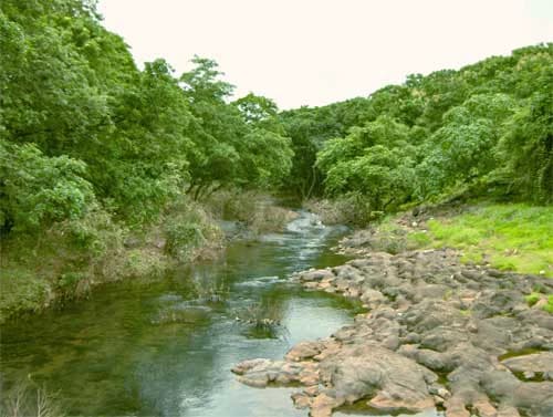
Sanjay Gandhi National Park landscape and geographic character

The forest composition includes species typical of the moist deciduous forests of the Western Ghats region, with a canopy that ranges from 15 to 25 meters in height in mature areas. The forest floor supports a diverse understory, and the park's location at the transition between the Western Ghats and the coastal plain contributes to its ecological diversity. Despite being entirely surrounded by urban development, the park maintains a contiguous forest cover that provides habitat for species ranging from large mammals to numerous insect and butterfly species.

Monkey Brothers.jpg
Two monkeys eating fruit together.

Sanjay Gandhi National Park ecosystems, habitats, and plant life

The park is particularly notable for its butterfly diversity, with over 150 species recorded, making it an important location for Lepidoptera research and observation in an urban context. The five thousand insect species documented in the park contribute to pollination, decomposition, and food web dynamics that sustain the broader ecosystem. The forest also supports the phenomenon of mass flowering of karvi (Strobilanthes), which occurs periodically across the Mumbai region, with the park's karvi populations flowering in synchrony with those in hill stations like Khandala and one year earlier than populations in Bhimashankar and Malshej Ghat.

Sanjay Gandhi National Park wildlife and species highlights

The reptile population is particularly diverse, with 38 species documented including crocodiles in Tulsi Lake, pythons, cobras, checkered keelbacks, common kraits, monitor lizards, Russell's vipers, bamboo pit vipers, and Indian cat snakes. The avian community includes 251 bird species, ranging from resident forest birds like jungle owlets, golden orioles, racket-tailed drongos, minivets, hornbills, and woodpeckers to migratory species including various kingfishers, gulls, egrets, and herons. The park also supports nine amphibian species, contributing to the overall biodiversity that makes this urban forest remarkable.

Sanjay Gandhi National Park conservation status and protection priorities

The park's conservation significance is enhanced by proposals to protect interlinked habitat corridors connecting it to nearby forest areas in Maharashtra, which would strengthen the conservation status of the broader regional landscape. The presence of a potential tiger population, even if transient, indicates the park's role in the broader conservation network for large carnivores in the Western Ghats region. Conservation efforts focus on maintaining habitat quality, managing human-wildlife conflict, and preserving the archaeological heritage represented by the Kanheri Caves.

Sanjay Gandhi National Park cultural meaning and human context

The caves remain significant for Buddhist pilgrimage and attract both religious visitors and archaeological enthusiasts. The relationship between the natural landscape and the religious structures carved into the rock demonstrates how ancient communities integrated spiritual practice with the natural environment. The park's cultural context extends beyond the caves to include the broader landscape that has been part of regional history for centuries, with the forest itself having been managed and used by local communities in various ways over time.

Top sights and standout views in Sanjay Gandhi National Park

The combination of ancient Buddhist archaeology, urban forest ecology, and wildlife conservation makes Sanjay Gandhi National Park a uniquely valuable protected area. The Kanheri Caves offer a window into 2,400 years of religious history, while the surrounding forest provides habitat for leopards, diverse reptiles, and over 250 bird species. The park's position within Mumbai makes it exceptionally accessible, allowing millions of city residents to experience natural environments without traveling beyond the metropolitan area.

Best time to visit Sanjay Gandhi National Park

The best time to visit Sanjay Gandhi National Park is during the winter months from October to March, when temperatures are cooler and the forest is more comfortable for extended walks and exploration. The monsoon season from June to September brings heavy rainfall to the Mumbai region, which can make trail conditions difficult but also enhances the lushness of the forest vegetation. The summer months from April to June can be quite hot, though early morning visits offer the best chance of wildlife observation when animals are most active.

Park location guide

Geography guide, regional context, and park location map for Sanjay Gandhi National Park

Sanjay Gandhi National Park park geography, regions, and map view in India
Understand where Sanjay Gandhi National Park sits in India through a broader geographic reading of the surrounding landscape, nearby location context, and its mapped position within the national park landscape.

How Sanjay Gandhi National Park fits into India

India is a South Asian country bordered by the Indian Ocean, Arabian Sea, and Bay of Bengal. It shares land borders with Pakistan, China, Nepal, Bhutan, Bangladesh, and Myanmar. The country has a population of over 1.4 billion people and operates as a federal parliamentary republic with its capital in New Delhi.

Wider geography shaping Sanjay Gandhi National Park in India

India occupies the Indian subcontinent in South Asia, bordered by the Arabian Sea to the southwest, the Bay of Bengal to the southeast, and the Indian Ocean to the south. It shares land borders with Pakistan to the west, China, Nepal, and Bhutan to the north, and Bangladesh and Myanmar to the east. The territory also includes the Andaman and Nicobar Islands in the Indian Ocean.

Map view of Sanjay Gandhi National Park

Use this park location map to pinpoint Sanjay Gandhi National Park in India, understand its exact geographic position, and read its mapped placement within the surrounding landscape more clearly.

Pigeon | © OpenStreetMap contributors

Location context for Sanjay Gandhi National Park

Maharashtra

Trace the varied terrain, moist deciduous forests, and archaeological sites that define this protected urban wilderness.

Sanjay Gandhi National Park Imagery: Explore Landscapes, Habitats, and Ancient Kanheri Caves
Visually explore Sanjay Gandhi National Park's diverse landscapes, from its moist deciduous forests and dramatic basaltic cliffs to the intricate ancient Buddhist Kanheri Caves carved into its terrain. These images provide crucial insight into the park's unique urban wilderness character, revealing its vital habitats and archaeological significance within the Mumbai metropolitan area.

White tiger

SGNP-Bombay.jpg

Monkey Brothers.jpg

Park atlas

Trace the diverse protected landscapes, urban wildernesses, and conservation zones across the surrounding Indian subcontinent.

Explore Other National Parks and Protected Areas Near Sanjay Gandhi National Park
Continue your exploration from Sanjay Gandhi National Park by discovering other protected areas and national parks throughout the surrounding Western Ghats and coastal plain regions of India. Comparing these diverse landscapes provides essential geographic context for understanding regional conservation efforts and distinct ecological zones, offering a richer atlas view of India's protected land.
National parkNavsari District

Vansda National Park: Protected Deciduous Forest Landscape within the Western Ghats

Explore the mapped geography and biodiversity of this Navsari District national park.

Vansda National Park stands as a crucial protected area in Navsari District, Gujarat, preserving the characteristic dense deciduous forests and extensive bamboo groves of the Western Ghats. The park's geography is shaped by its location along the Ambika River, presenting a landscape of rolling hills and forested valleys within this significant biodiversity hotspot. Users can delve into its protected land status, mapped terrain, and the unique ecological attributes that make it a noteworthy national park for geographic and conservation exploration.

Area
23.99 km²
Established
1979
IUCN
II
National parkBhavnagar District

Blackbuck National Park: Gujarat's Grassland Protected Landscape and Wildlife Atlas

Mapped semi-arid terrain and endangered species habitat.

Blackbuck National Park in Bhavnagar District, India, presents a unique focus on semi-arid grassland ecosystems and their protection. This national park showcases a flat, expansive landscape that borders coastal tidal zones, offering a distinct geographic context for its rich biodiversity. As a critical habitat for the blackbuck antelope and the endangered lesser florican, its protected area status is paramount. Exploring this park through its mapped boundaries and regional geography reveals its importance within India's network of conservation landscapes.

Area
34.08 km²
Established
1976
IUCN
II
Relief
Lowland
National parkTelangana

Mrugavani National Park: Telangana's Protected Area within the Deccan Plateau's Natural Landscape

Explore undulating terrain and tropical dry forest ecosystems.

Mrugavani National Park represents a significant protected landscape within Telangana, India, characterized by its characteristic Deccan Plateau geography. Covering 1,211 acres, this national park features a terrain of rocky outcrops and undulating topography supporting a tropical dry deciduous forest ecosystem. It serves as a critical refuge for native flora and fauna, including a notable population of spotted deer, and offers a valuable case study in regional conservation and mapped protected areas near urban centers.

Area
4.9 km²
Established
1994
IUCN
II
Relief
Upland
National parkRajasthan

Mukundara Hills National Park: Rajasthan's Protected Landscape for Tigers and Diverse Habitats

Explore its dry deciduous forests, rocky hills, and riverine ecosystems.

Mukundara Hills National Park is a significant national park and tiger conservation landscape situated in eastern Rajasthan, India. This protected area features a varied terrain encompassing rocky hills, dry deciduous forests, and crucial grassland patches, all intersected by major rivers like the Chambal. Its ecological importance lies in providing vital habitat for Bengal tigers and a mosaic of landscapes that support a wide array of wildlife. Understanding its mapped boundaries and geographic context reveals its critical role in regional conservation efforts and provides a rich atlas-level view of protected lands in western India.

Area
759.99 km²
Established
2004
IUCN
II
National parkKarnataka

Kudremukh National Park: Karnataka's Protected Landscape and River Origin

Explore the geography of shola forests and grasslands.

Kudremukh National Park is a pivotal protected landscape in Karnataka, India, recognized for its distinctive montane grasslands and shola forests. This national park is a critical source for three major rivers: the Tunga, Bhadra, and Nethravathi, highlighting its ecological and geographic significance within the Western Ghats. The park's terrain features rolling hills and steep western slopes, contributing to its unique biodiversity and landscape character for atlas-based discovery.

Area
600.57 km²
Established
1987
IUCN
II
Relief
Mountain
National parkRajasthan

Desert National Park: A Sprawling National Park in Rajasthan's Thar Desert

Explore unique desert geography, mapped terrain, and fossil discoveries.

Desert National Park offers an expansive atlas view of the Thar Desert's unique aeolian sand deposits and arid terrain. Covering over 3,100 square kilometers across Rajasthan's Jaisalmer and Barmer districts, this national park is a critical landscape for desert conservation. Its features include iconic sand dunes, rocky formations, and ancient fossil beds, providing a profound geographic context for understanding desert ecosystems and prehistoric life.

Area
3,162 km²
Established
1981
IUCN
II
National parkMadhya Pradesh

Kuno National Park: Madhya Pradesh National Park Atlas and Protected Landscape

Explore its diverse dry deciduous forests and savannah terrain.

Kuno National Park is a protected area in Madhya Pradesh, India, renowned for its dry deciduous forest and savannah grassland ecosystems. This national park, bisected by the Kuno River, offers a significant landscape for understanding regional geography and conservation efforts within India. Its varied terrain provides essential habitat and contributes to the broader atlas of protected lands, making it a key destination for geographic discovery.

Area
748.76 km²
Established
2018
IUCN
II
National parkRajasthan

Ranthambore National Park: Protected Area Atlas and Dry Deciduous Landscape Exploration

Discover its unique terrain and mapped boundaries.

Dive into the protected landscape of Ranthambore National Park, a nationally significant protected area in Rajasthan, India. This page offers detailed insights into its dry deciduous forest ecosystem, characterized by rocky hills, open grasslands, and vital lakes. Explore the park's mapped boundaries and understand its position within the regional geography, providing an atlas-centric view of its terrain and conservation importance.

Area
1,334 km²
Established
1980
IUCN
II

Common questions about visiting, size, designation, and location context for Sanjay Gandhi National Park

Sanjay Gandhi National Park FAQs for park facts, access, geography, and protected area context
Find quick answers about Sanjay Gandhi National Park, including protected-area facts, park geography, trail and visitor context, and how the park fits into its surrounding country and regional landscape.
MoriAtlas Explorer

Continue Your Protected Areas Search Across the Global Atlas

Deepen your exploration by continuing the structured search for national parks and protected areas worldwide. Utilize the comprehensive filtering capabilities to compare different conservation landscapes and refine your understanding of global park geography. Discover more about the distribution and characteristics of protected natural areas.

Global natural geography