Mori Atlas logo
National parkLa Campana National Park

Discover unique palm forests and historic summit routes within the Valparaíso Region.

La Campana National Park: Protected Landscape & Atlas of Chilean Geography

(Parque Nacional La Campana)

La Campana National Park stands as a vital protected landscape within Chile's Valparaíso Region, offering an unparalleled opportunity for geographic discovery. This national park preserves one of the last natural stands of the Chilean Wine Palm, a species with significant botanical heritage, alongside diverse sclerophyllous woodlands and dramatic coastal mountain terrain. Its mapped boundaries encompass significant ecological zones, providing a concrete example of Chile's unique Mediterranean ecosystems and a key reference point for regional geography and atlas exploration.

mediterranean forestpalm forestUNESCO biosphere reserveDarwin historic siteChilean matorralcoastal mountains

La Campana National Park

National park

Park overview

Structured park overview, official facts, and landscape profile for La Campana National Park

La Campana National Park park facts, protected area profile, and essential visitor context
Review the core facts for La Campana National Park, including designation, size, terrain, visitor scale, habitats, and operating context in one park-focused overview.

About La Campana National Park

La Campana National Park occupies a remarkable position in Chile's protected area system, combining exceptional botanical significance with geological, historical, and cultural values. The park lies within the Chilean Coast Range northwest of Santiago, spanning elevations from approximately 300 meters to 1,828 meters at the summit of Cerro La Campana. The terrain is characterized by three principal watersheds corresponding to the Granizo, Ocoa, and Cajón Grande sectors, each containing distinct ecological communities influenced by aspect, altitude, and moisture gradients. The park's global significance stems primarily from its role as a conservation refuge for Jubaea chilensis, the Chilean Wine Palm, whose current distribution is limited to approximately 20 isolated populations, with the Palmar de Ocoa being the most extensive. This species can reach heights of 30 meters and may live up to 400 years, representing a botanical treasure of considerable scientific and cultural value. Beyond the palms, the park protects a complex mosaic of Mediterranean ecosystems including sclerophyllous forest, deciduous woodland dominated by Nothofagus macrocarpa (roble), espinal shrubland, and relictual humid forest in the deeper canyons. The area has been subject to human occupation since pre-Columbian times, with archaeological evidence of Llolleo, Bato, and Aconcagua cultures, followed by intensive mining activity from the colonial period through the late twentieth century, traces of which remain visible along several trails.

Quick facts and research context for La Campana National Park

La Campana National Park is situated in central Chile's Valparaíso Region, about 60 kilometers from Valparaíso and 160 kilometers from Santiago, with the nearest access points through the towns of Olmué and Hijuelas. The park covers 8,000 hectares and was established in 1967 under Law N° 16,699, with its boundaries formally defined in 1985 through Supreme Decree N° 228. The protected area is administered by Chile's National Forestry Corporation (CONAF) and was declared a UNESCO Biosphere Reserve in 1984, making it one of nine biosphere reserves in Chile. The park's three main sectors are Granizo, Palmas de Ocoa, and Cajón Grande, each offering distinct ecosystems and recreational opportunities. The region experiences a Mediterranean climate with average temperatures around 18°C and annual precipitation of approximately 480 millimeters, concentrated during the winter months.

Park context

Deeper park guide and search-rich context for La Campana National Park

La Campana National Park history, landscape, wildlife, and travel context
Explore La Campana National Park through its history, landscape character, ecosystems, wildlife, conservation priorities, cultural context, and seasonal travel timing in a structured park guide built for atlas discovery and search intent.

Why La Campana National Park stands out

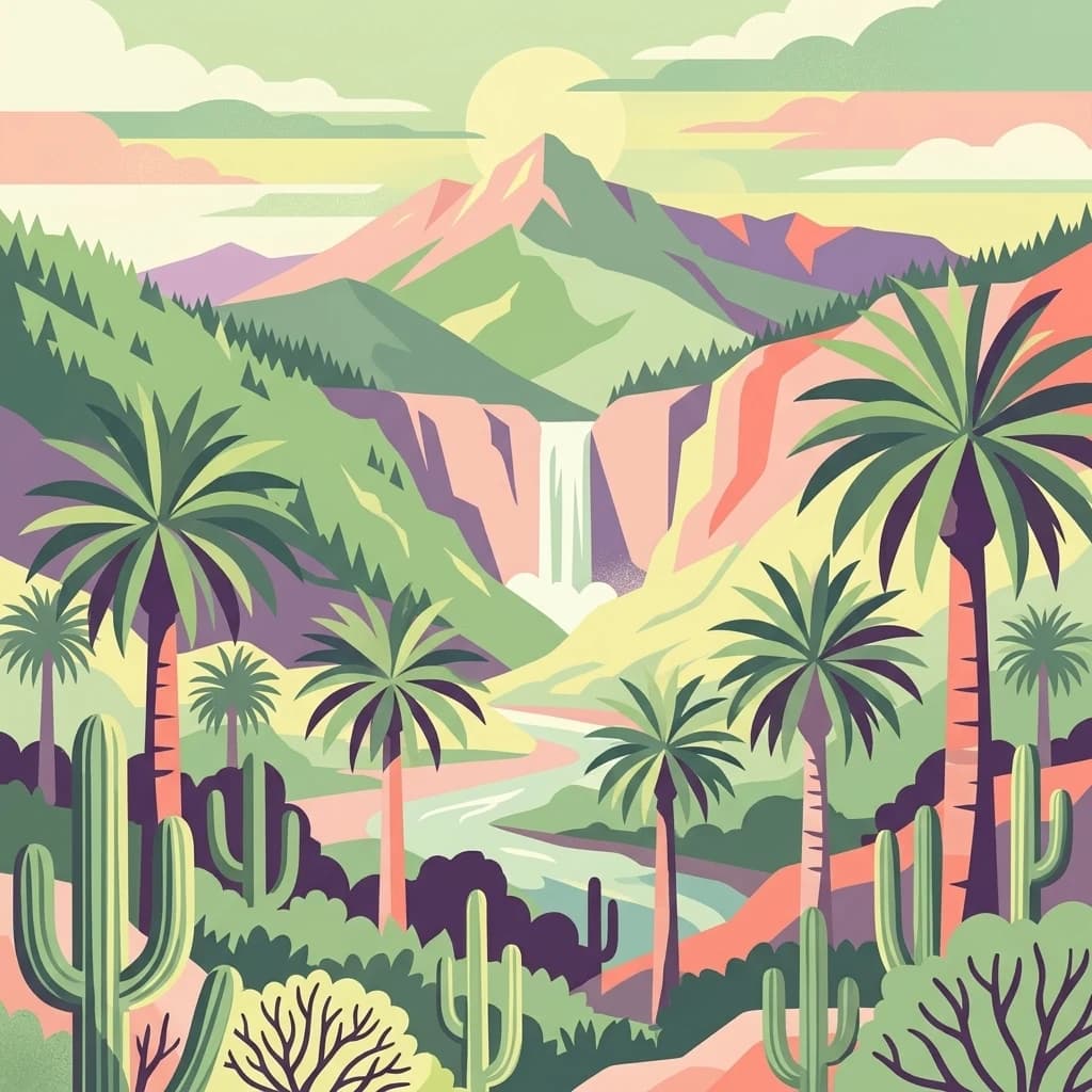
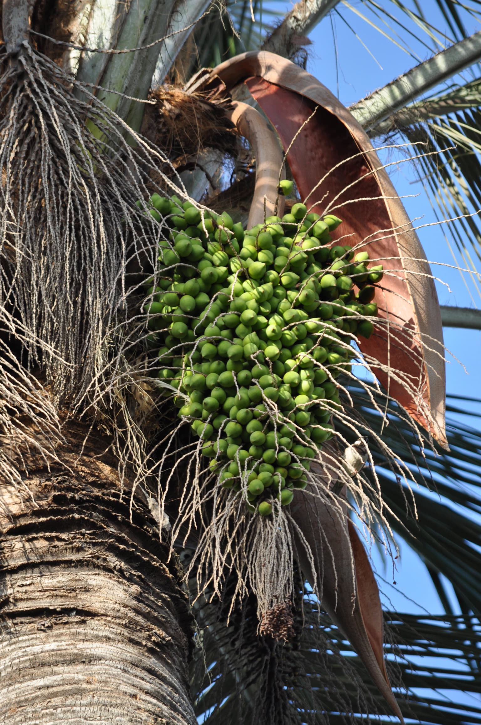
La Campana National Park is best known for the Palmar de Ocoa, which contains the largest and densest population of Jubaea chilensis, the Chilean Wine Palm, the most southerly-growing palm species in the world among continental varieties. This palm forest, with approximately 62,000 individual specimens concentrated in the Ocoa Valley, represents a living relic of prehistoric vegetation that once covered much of central Chile. The park is also famous for Cerro La Campana itself, the 1,828-meter peak that provided Charles Darwin with his first major South American mountain ascent in 1834, a journey that influenced his developing theories on natural selection. The biodiversity significance is exceptional, with over 545 vascular plant species recorded, representing more than 20 percent of Chile's total flora within just 0.1 percent of the country's territory. The park also protects important old-growth forests of sclerophyllous woodland, deciduous roble forests, and relictual humid forest communities.

Alstroemeria ligtu var Simsii, La Campana National Park
Photograph of Alstroemeria ligtu, var. Simsii, taken in Primera Aguada, on the Sendero del Andinista trail in La Campana National Park.

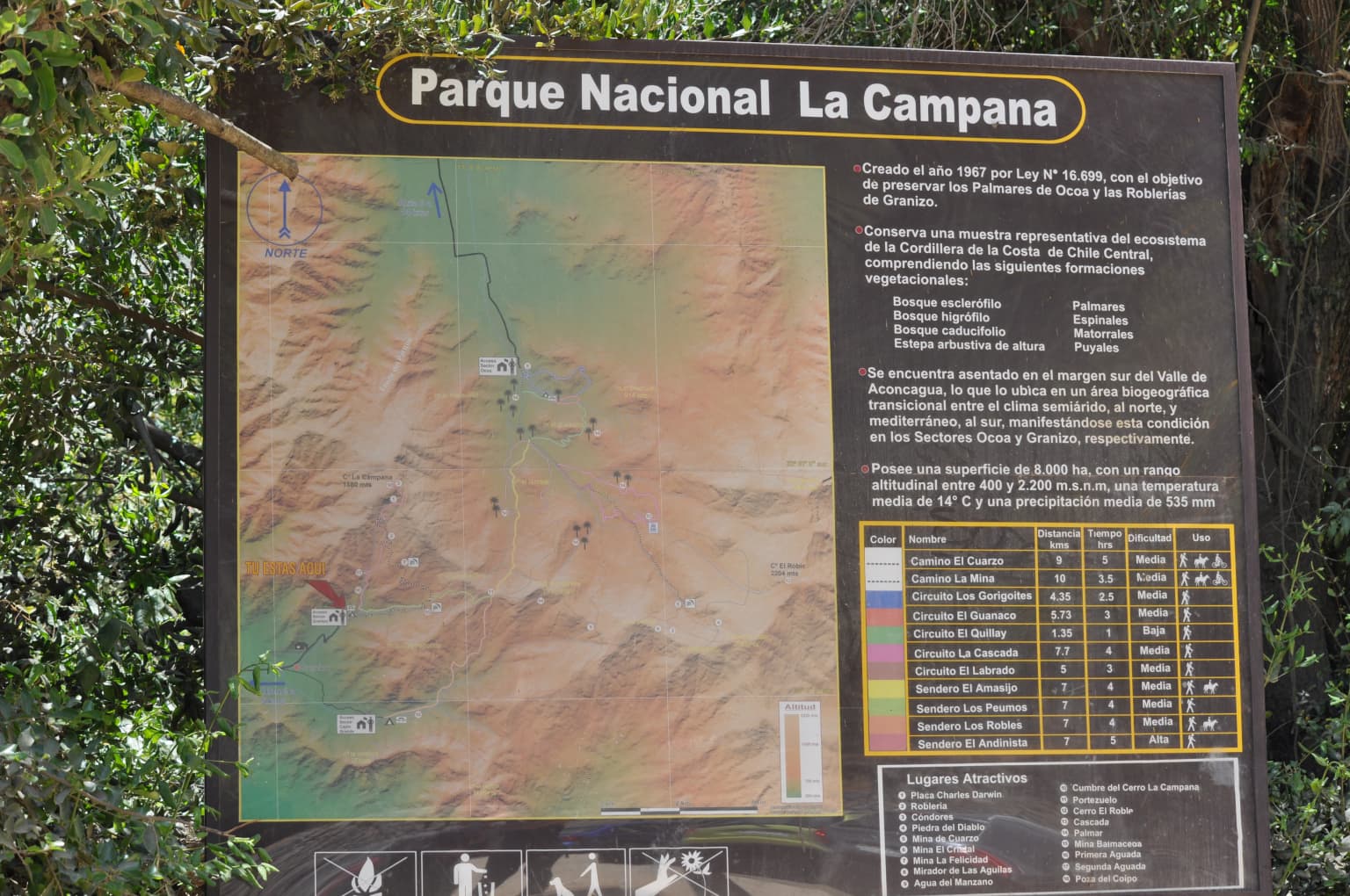
La Campana National Park history and protected-area timeline

The human history of La Campana spans thousands of years, beginning with pre-Columbian cultures that inhabited the area from at least 300 BCE. Archaeological excavations have uncovered ceramics, stone tools, mortars, and manos de moler (grinding stones), indicating sustained human presence and resource use of local plants including the fruits of Jubaea chilensis. The Llolleo culture (300-900 CE) and Bato tradition (860 BCE-800 CE) occupied the area, followed by the more extensive Aconcagua culture (900 CE until Spanish arrival), which left abundant evidence of their presence throughout the park. Following the Spanish conquest, the region attracted miners seeking gold, with activity documented from the 1560s extending through the colonial period and intensifying during the eighteenth and nineteenth centuries as copper mining became predominant. The mountain was known to indigenous Picunche peoples as Gulmué and held sacred significance. In 1834, Charles Darwin made his historic ascent of Cerro La Campana on August 17, spending two days traversing the mountain on horseback and foot, describing several species for the first time and leaving a legacy that continues to draw scientific and historical interest. Mining continued until 1994, with the final closure occurring after environmental legislation halted extraction activities. Conservation efforts began in earnest during the twentieth century, with botanist Gualterio Looser proposing protection in 1936 and a successful campaign led by Agustín Garaventa and Álvaro Valenzuela resulting in the park's formal creation on October 17, 1967. UNESCO designated the area as a Biosphere Reserve in 1984.

La Campana National Park landscape and geographic character

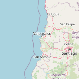
The physical landscape of La Campana National Park is defined by the coastal mountain range of central Chile, with terrain ranging from gentle valleys at lower elevations to rugged mountain terrain approaching 2,000 meters. Cerro La Campana itself rises to 1,828 meters and presents a distinctive profile that resembles a bell when viewed from the Aconcagua Valley, explaining both its name and its landmark status in the region. Other significant peaks include Cerro El Roble (2,222 meters), El Litre (1,621 meters), and El Imán (2,035 meters), creating a complex topography of ridges, valleys, and canyons. The park divides naturally into three major basins: the Granizo watershed, smallest and containing Cerro La Campana as its high point; the larger Ocoa watershed separated by a ridge of hills including El Litre; and the Cajón Grande watershed to the east. The geology dates primarily to the Cretaceous period, with the oldest rocks (approximately 135 million years) forming the ridge from Las Campanitas to Santa Teresa, composed of crystalline rocks from the Lo Prado Formation. More common are gabbro and granodiorite formations from the late Cretaceous to early Tertiary. The combination of elevation, aspect, and proximity to the Pacific Ocean creates distinct microclimimes, with four defined climatic zones: the windward (barlovento) slopes receiving over 400 mm annually, the more arid leeward (sotavento) slopes, the cool and moist umbría on south-facing slopes, and the warmer solana on northern exposures.

Calceolaria corymbosa ssp. corymbosa
Capachito, a subspecies of Calceolaria corymbosa

La Campana National Park ecosystems, habitats, and plant life

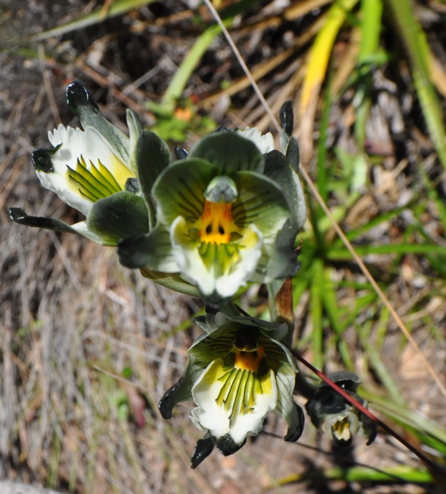
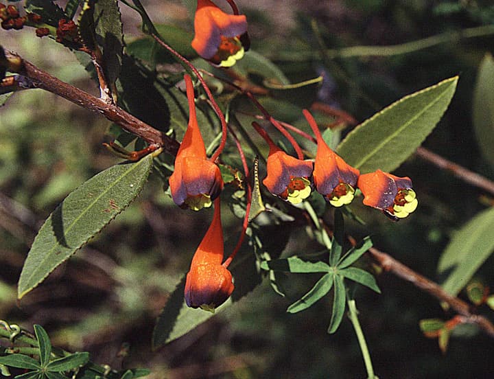
The ecological character of La Campana reflects its position within the Chilean matorral ecoregion, a Mediterranean-type ecosystem characterized by wet winters and dry summers that has produced distinctive adaptations among resident species. The park's botanical richness is extraordinary, supporting approximately 545 vascular plant species representing more than 20 percent of Chile's total flora within a relatively small area. This diversity results from the park's position at a biogeographic crossroads where species from multiple floristic elements converge, including central Chilean, subantarctic, Andean, neotropical, gondwanan, and pantropical components. The dominant plant communities include sclerophyllous forest dominated by peumo (Cryptocarya alba), boldo (Peumus boldus), quillay (Quillaja saponaria), and litre (Lithraea caustica), often with Jubaea chilensis as a codominant. Deciduous roble (Nothofagus macrocarpa) forests occur at higher elevations on south-facing slopes, representing relictual communities unusual at this latitude. Humid laurel forest persists in the deepest canyons where moisture conditions permit. The park also contains extensive espinal shrubland and matorral communities, particularly on drier north-facing slopes, with characteristic spiny shrubs and succulents including various cacti and Puya species. The flora includes notable endemism, particularly among the herbaceous layer with numerous endemic alstroemerias, calceolarias, orchids, and mutisias.

Calceolaria morisii Walp. by Pato Novoa
Calceolaria morisii, endemic plant found in Los Vilos, near La Campana National Park

La Campana National Park wildlife and species highlights

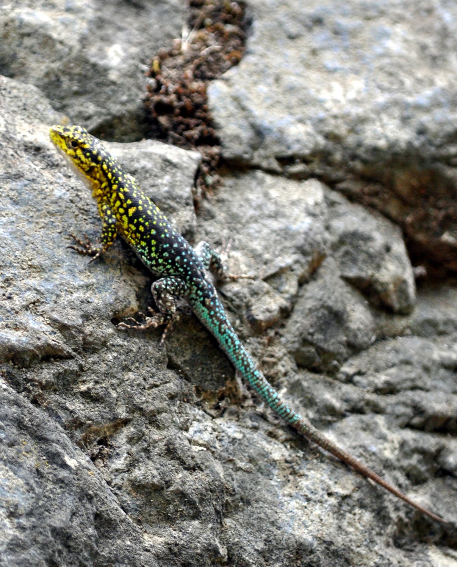
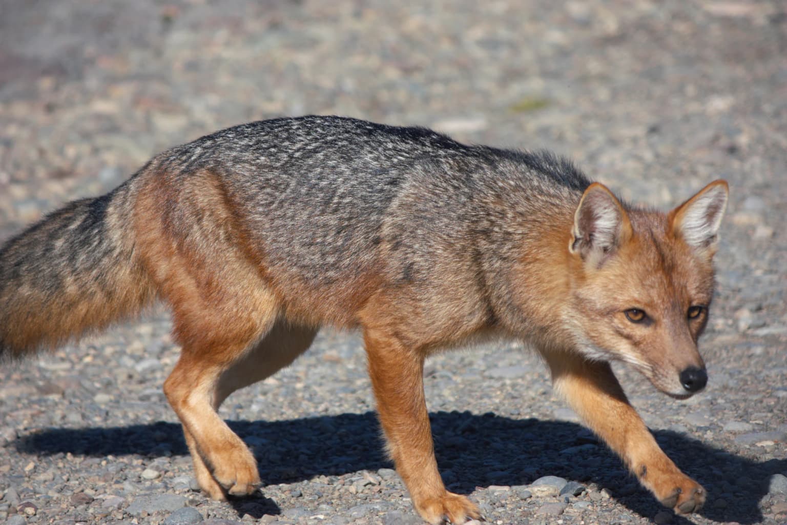
La Campana supports a diverse fauna representing typical Mediterranean communities of central Chile, with particular significance attached to several predator species and endemic forms. Mammal diversity includes carnivores such as the culpeo fox (Lycalopex culpaeus), chilla fox (Lycalopex griseus), puma (Puma concolor), colocolo (Leopardus colocolo), and the small güiña (Leopardus guigna). The park also hosts mustelids including the quique (Galictis cuja) and the skunk-like chingue (Conepatus chinga). Rodents are particularly abundant, with 13 species recorded including the diurnal degú (Octodon degus) and vizcacha (Lagidium viscacia), alongside numerous nocturnal species. Birdlife is rich, with the park offering excellent birdwatching opportunities for species including the endemic tapaculo (Scelorchilus albicollis), turca (Pteroptochos megapodius), and numerous raptors including the Andean condor (Vultur gryphus). Reptiles include several Liolaemus lizard species and two snake species. The fauna community structure shows a predominance of herbivores among mammals and songbirds among avifauna, with carnivores and raptors present but in lower densities.

Callopistes maculatus.jpg
Chilean iguana (Callopistes maculatus)

La Campana National Park conservation status and protection priorities

La Campana National Park holds exceptional conservation significance as a refuge for species and ecosystems that have been largely eliminated from the surrounding agricultural landscape of central Chile. The park's core conservation value centers on protecting the largest remaining population of Jubaea chilensis, the Chilean Wine Palm, which has suffered dramatic range reduction due to habitat conversion, fire, and seed predation by introduced rodents. The palm population faces ongoing challenges with regeneration rates of only 1.23 seedlings per mature tree, insufficient to sustain the population long-term without active management. The designation as a UNESCO Biosphere Reserve in 1984 recognized both the exceptional biodiversity and the park's role as a model for integrating conservation with sustainable use. The park also protects remnants of sclerophyllous forest, one of Chile's most threatened native forest types, as well as deciduous roble forests that represent southern species at their northern range limits. Mining activity within the park ceased in 1994 following environmental legislation, though the subsoil remains designated as a place of scientific interest for mining purposes under the Mining Code. Management challenges include balancing recreation pressures from the highly populated Valparaíso Region, controlling invasive species, and addressing the impacts of prolonged drought on water availability and ecosystem health.

La Campana National Park cultural meaning and human context

The cultural dimension of La Campana extends from pre-Columbian times through the colonial period to the present, with the park embodying layers of human interaction with the landscape. Archaeological evidence confirms occupation by multiple prehispanic cultures including the Llolleo, Bato, and particularly extensive Aconcagua culture remains, with artifacts including ceramics, grinding stones, and the enigmatic

Cerro La Campana from hiking trail
View of Cerro La Campana from the hiker's trail, inside La Campana National Park, ascending from the Granizo sector.

Top sights and standout views in La Campana National Park

The Palmar de Ocoa represents the park's flagship attraction, containing the world's most extensive stand of Jubaea chilensis, the Chilean Wine Palm, with approximately 62,000 specimens creating a landscape of exceptional botanical significance. The Sendero del Andinista trail to the summit of Cerro La Campana follows the historic route taken by Charles Darwin in 1834, offering spectacular views from the 1,828-meter summit on clear days extending from the Andes to the Pacific coast. The park's botanical diversity, with over 545 vascular plant species representing more than 20 percent of Chile's flora, supports remarkable displays of endemic flowers including alstroemerias, calceolarias, orchids, and mutisias across different elevations and habitats. The four distinct climatic zones within the park create varied walking experiences from the moist windward forests to the drier leeward matorral, each supporting different plant communities. The sector-based organization of the park (Granizo, Ocoa, Cajón Grande) allows visitors to explore distinct environments, with the Ocoa sector offering the densest palm forest at approximately 113 individuals per hectare.

Chusquea cumingii
La Campana National Park, Chile

Best time to visit La Campana National Park

The optimal time to visit La Campana depends on interests, with the Mediterranean climate creating distinct seasons affecting the visitor experience. Spring (September to November) brings warmer temperatures and flowering of many herbaceous species including alstroemerias and calceolarias, though drought conditions typically persist through early summer. Summer (December through March) offers the warmest conditions for hiking but coincides with the dry season when water sources may be limited on trails, though this is peak season for tropical bird species. Autumn (April to May) sees the return of rains, greening of the landscape, and the opportunity to observe deciduous trees changing color, particularly the robles at higher elevations. Winter (June through August) brings the bulk of annual precipitation, creating lush conditions but potentially limiting trail accessibility, though this is the best season for observing waterfalls and full watercourses. The park is most visited during Chilean holiday periods (January, February, and national holidays), while the quieter months of April through June and August through September offer more solitary exploration opportunities.

Park location guide

Geography guide, regional context, and park location map for La Campana National Park

La Campana National Park park geography, regions, and map view in Chile
Understand where La Campana National Park sits in Chile through a broader geographic reading of the surrounding landscape, nearby location context, and its mapped position within the national park landscape.

How La Campana National Park fits into Chile

Chile is a presidential republic in western South America, extending as a narrow strip along the western edge of the continent between the Andes Mountains and the Pacific Ocean. It is the southernmost country in the world and the closest to Antarctica. The country is bordered by Peru, Bolivia, and Argentina, and administers several Pacific islands including Easter Island. Chile is a major copper producer and has a population of approximately 19.6 million.

Wider geography shaping La Campana National Park in Chile

Chile occupies a narrow strip of land along the western edge of South America, extending approximately 4,300 km north to south but only about 350 km east to west at its widest point. The country is sandwiched between the Andes Mountains to the east and the Pacific Ocean to the west. It shares borders with Peru to the north, Bolivia to the northeast, and Argentina to the east. Southern Chile borders the Drake Passage. Chile also administers several Pacific islands including Juan Fernández Islands, Isla Salas y Gómez, Desventuradas Islands, and Easter Island, plus the Chilean Antarctic Territory.

Map view of La Campana National Park

Use this park location map to pinpoint La Campana National Park in Chile, understand its exact geographic position, and read its mapped placement within the surrounding landscape more clearly.

Pigeon | © OpenStreetMap contributors

Location context for La Campana National Park

Quillota ProvinceValparaíso Region

Visualizing the diverse scenery and protected-area character of central Chile's mountain and palm forest environment.

La Campana National Park Photos: Explore Landscapes, Habitats, and Iconic Chilean Palm Forests
Delve into the visual geography of La Campana National Park, observing its unique Mediterranean landscapes, iconic Chilean Wine Palm forests, and rugged mountain terrain. High-quality imagery helps clarify the park's distinct plant communities, varied microclimates, and significant conservation value as a UNESCO Biosphere Reserve in central Chile.

Alstroemeria ligtu var Simsii, La Campana National Park

Beilschmiedia miersii (belloto) in La Campana National Park

Calceolaria corymbosa ssp. corymbosa

Calceolaria morisii Walp. by Pato Novoa

Callopistes maculatus.jpg

Cerro La Campana from Pelumpén

Cerro La Campana from hiking trail

Chusquea cumingii

Cougar track

Cryptocarya alba (Peumo) at La Campana National Park

Cyperus eragrostis in La Campana National Park

La Campana National Park Entrance.jpg

Flora del bosque relicto Cerro Santa Inés 02.JPG

Jubaea chilensis detail of Chilean palm fruits

Liolaemus nitidus in La Campana National Park

Jubaea chilensis (scott.zona) 001.jpg

Park atlas

Trace the protected landscapes and park geography surrounding La Campana National Park in central Chile's coastal ranges.

Compare Nearby National Parks and Protected Areas Around La Campana National Park
Browse a focused list of national parks and other protected areas situated near La Campana National Park, encompassing distinct Mediterranean and coastal mountain landscapes. Explore these protected areas to compare their distinct features, understand regional conservation strategies, and trace their geographic spread across Chile's central coastal range.
National parkLa Rioja Province

Talampaya National Park: Argentinian National Park with Dramatic Desert Canyons

Explore protected landscape and mapped geography in La Rioja Province.

Talampaya National Park, a significant national park in Argentina's La Rioja Province, offers a profound exploration of a dramatic desert canyon environment. This protected area is renowned for its rich paleontological sites, yielding crucial dinosaur fossils, and for its well-preserved indigenous petroglyphs carved into ancient rock formations. Understanding Talampaya National Park provides vital context for the region's geography and its place within Argentinian protected lands and mapped natural landscapes.

Area
2,150 km²
Established
1997
IUCN
II
National parkAtacama Region

Llanos de Challe National Park: Unique Coastal Desert and Lomas Ecosystem

Atacama Region National Park with Dramatic Terrain and Wildlife

Llanos de Challe National Park presents a rare protected coastal desert environment within the Atacama Region. Its unique lomas ecosystem, sustained by coastal fog, supports a surprising diversity of life. The park encompasses striking geographic features, from unspoiled white-sand beaches to rugged mountainous terrain, offering a clear example of a vital protected landscape with significant guanaco populations and unique flora, all mapped within its regional context.

IUCN
II
National parkLa Araucanía Region

Nahuelbuta National Park: Ancient Araucaria Forests and Protected Highland Geography

Discover its mapped boundaries atop the Cordillera de Nahuelbuta.

Nahuelbuta National Park is a significant national park in Chile's La Araucanía Region, celebrated for its ancient monkey puzzle tree forests atop the Cordillera de Nahuelbuta. This protected area showcases a unique highland landscape with rugged terrain and exposed rocky outcrops, preserving species more typical of Andean and Patagonian environments. Understanding its mapped geography and protected landscape identity is key to appreciating its ecological importance and distinct position within South America's natural atlas.

Area
68 km²
Established
1939
IUCN
II
National parkCórdoba Province

Quebrada del Condorito National Park: Mapped Protected Landscape and Biological Island Ecosystem

Argentina National Park in Córdoba Province

Quebrada del Condorito National Park is a federally protected area in Argentina's Córdoba Province, established to safeguard a significant portion of the Sierras Pampeanas mountain ecosystem. The park's rugged terrain, including deep gorges and high-altitude plateaus, creates a distinct biological island environment supporting a wealth of endemic species. Its geographic isolation and dramatic landscape make it a unique focus for protected-area discovery and understanding Argentina's natural geography.

Area
373.44 km²
Established
1996
IUCN
II
National parkLa Araucanía Region

Huerquehue National Park: Ancient Araucaria Forests and Glacial Lakes in La Araucanía

Mapped protected area in the Andean foothills of Southern Chile.

Delve into the protected landscape of Huerquehue National Park, a key component of Chile's southern conservation efforts within the La Araucanía Region. This national park is defined by its ancient araucaria forests, home to the iconic monkey puzzle tree, and a network of clear glacial lakes including Tinquilco Lake. Its mountainous terrain, rising from 720 to 2,000 meters, showcases a vital representative of the Andean-Patagonian forest ecosystem, offering rich context for map exploration and understanding protected-area geography.

Area
125 km²
Established
1967
IUCN
II
National parkNeuquén Province

Lanín National Park: Volcanic Landscapes and Ancient Forests in Neuquén Province

Explore the protected area's mapped terrain and glacial lakes.

Lanín National Park offers a deep dive into the dramatic geography of Argentine Patagonia, centered around the prominent Lanín volcano. This national park preserves ancient araucaria forests, diverse ecosystems, and breathtaking glacial lakes like Huechulafquen and Lácar. Its extensive protected landscape provides critical habitat and opportunities to explore unique Andean terrain through map-driven discovery.

Area
3,790 km²
Established
1937
IUCN
II
National parkTucumán Province

Aconquija National Park: Southern Andean Yungas Protected Landscape in Tucumán Province

Explore its montane forest and mapped geographic context.

Aconquija National Park is a significant federal protected area located in Tucumán Province, Argentina. This national park is dedicated to conserving the diverse Southern Andean Yungas montane forest ecosystem, characterized by a dramatic elevational gradient. Its landscapes transition from cloud forest to high alpine terrain, offering a unique opportunity to study and appreciate a well-preserved montane environment within a critical geographic region. Discover the mapped extent and ecological importance of this protected area.

Area
499.94 km²
Established
1995
IUCN
II
National parkLos Ríos Region

Alerce Costero National Park: Explore Protected Landscapes and Ancient Forests in Los Ríos Region

Discover mapped terrain and unique Valdivian ecosystem geography.

Alerce Costero National Park stands as a significant protected landscape in Chile's Los Ríos Region, celebrated for its ancient Fitzroya trees and as a sanctuary for the Valdivian temperate rainforest. The park's protected boundaries encompass rugged terrain within the Cordillera Pelada, offering insights into unique watershed geography and the resilience of an ancient forest ecosystem. Its diverse landscape, a mosaic of old-growth woods and natural clearings, provides essential habitat and a remarkable geographic context for atlas exploration.

Area
139.75 km²
Established
2010
IUCN
III

Common questions about visiting, size, designation, and location context for La Campana National Park

La Campana National Park FAQs for park facts, access, geography, and protected area context
Find quick answers about La Campana National Park, including protected-area facts, park geography, trail and visitor context, and how the park fits into its surrounding country and regional landscape.
MoriAtlas Explorer

Continue Your Protected Areas Search Across the Global Atlas

Deepen your exploration by continuing the structured search for national parks and protected areas worldwide. Utilize the comprehensive filtering capabilities to compare different conservation landscapes and refine your understanding of global park geography. Discover more about the distribution and characteristics of protected natural areas.

Global natural geography