Mori Atlas logo
National parkNorthern Luzon Heroes Hill National Park

Discover the dramatic terrain and protected forest boundaries of this unique Philippine national park.

Northern Luzon Heroes Hill National Park: Mapped Protected Landscape and Coastal Mountain Geography

Northern Luzon Heroes Hill National Park, situated in the Ilocos Sur region of the Philippines, represents a vital protected landscape characterized by its distinctive coastal mountain geography. This national park offers an atlas-like view of a rugged terrain rising from the South China Sea, featuring forested hills and ravines that contrast sharply with the surrounding flatlands. Explore the mapped boundaries and unique natural setting of this significant conservation area.

Mountain parksCoastal protected areasIUCN Category VPhilippines national parksForest conservationIlocos region

Northern Luzon Heroes Hill National Park

National park

Park overview

Structured park overview, official facts, and landscape profile for Northern Luzon Heroes Hill National Park

Northern Luzon Heroes Hill National Park park facts, protected area profile, and essential visitor context
Review the core facts for Northern Luzon Heroes Hill National Park, including designation, size, terrain, visitor scale, habitats, and operating context in one park-focused overview.

About Northern Luzon Heroes Hill National Park

Northern Luzon Heroes Hill National Park occupies a distinctive geographic position in the Ilocos Sur landscape, protecting a ridge of forested hills that rise sharply from the coastal plain along the South China Sea. The protected area straddles the boundary between the municipalities of Santa and Narvacan, encompassing the most significant remaining patch of forest cover in this heavily agricultural region. Established in 1963 during a period when the Philippines was expanding its national park system, the park was designated to preserve the scenic and ecological values of this mountainous coastal terrain. The park's establishment reflected growing recognition in the mid-20th century of the need to protect remaining natural areas from the expansion of agriculture and development that had already transformed much of the Ilocos landscape. Today, the park serves as an important ecological anchor for the region, providing habitat for species adapted to forest edge and interior environments while also offering recreational opportunities for residents and visitors to Ilocos Sur.

Quick facts and research context for Northern Luzon Heroes Hill National Park

Located in Ilocos Sur province on western Luzon, Northern Luzon Heroes Hill National Park covers 1,316 hectares of mountainous terrain adjacent to the South China Sea. The park was established on July 9, 1963, under Proclamation No. 132 and is classified as IUCN Category V, denoting a protected landscape. Elevations within the park reach approximately 465 meters, providing panoramic views of the coastal plain and sea. The nearest urban center is the historic city of Vigan, a UNESCO World Heritage Site located within convenient reach. The park offers opportunities for trekking, mountain biking, and sightseeing along its forest trails.

Park context

Deeper park guide and search-rich context for Northern Luzon Heroes Hill National Park

Northern Luzon Heroes Hill National Park history, landscape, wildlife, and travel context
Explore Northern Luzon Heroes Hill National Park through its history, landscape character, ecosystems, wildlife, conservation priorities, cultural context, and seasonal travel timing in a structured park guide built for atlas discovery and search intent.

Why Northern Luzon Heroes Hill National Park stands out

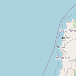
The park is best known for its dramatic hill and mountain landscape that stands in sharp contrast to the flat coastal plains characteristic of Ilocos Sur. Rising abruptly from the South China Sea coastline, the forested slopes of Heroes Hill create a notable scenic landmark visible from the MacArthur Highway that runs along this section of the Ilocos coast. The protected area preserves what remains of the original vegetation cover that once blanketed this portion of the Ilocos region, offering a glimpse of the pre-agricultural landscape that dominated before widespread deforestation for agriculture and settlement.

Northern Luzon Heroes Hill National Park history and protected-area timeline

Northern Luzon Heroes Hill National Park was established on July 9, 1963, through Proclamation No. 132 issued by the national government. The designation came during a period when the Philippines was systematically establishing protected areas across the archipelago, recognizing the importance of preserving representative samples of the country's diverse ecosystems. The park was created to protect the forested hills that form a natural backdrop to the coastal communities of Santa and Narvacan, preserving both scenic values and ecological functions in an area where forest cover had already been significantly reduced by agricultural expansion. The selection of this area for protection reflected the recognition that the remaining forest patches in Ilocos Sur held special significance for the region's identity and environmental health. The park has been managed by the Department of Environment and Natural Resources since its establishment, with the protected area status providing legal framework for conservation of its natural resources.

Northern Luzon Heroes Hill National Park landscape and geographic character

The landscape of Northern Luzon Heroes Hill National Park is defined by a series of forested ridges and valleys that rise from the coastal lowlands of Ilocos Sur to elevations of approximately 465 meters. The terrain is characterized by steep slopes, deep ravines, and rolling hill crests that create a complex topography quite different from the flat alluvial plain that dominates the surrounding agricultural landscape. The park sits directly along the South China Sea coast in its lower elevations, with coastal cliffs and slopes descending to the shoreline in some areas. The underlying geology and soils of the area have contributed to the persistence of forest cover where other parts of Ilocos Sur have been completely converted to agricultural use. The visual impact of the green forested hills against the blue sea and the cultivated fields of the coastal plain creates a landscape of significant scenic value, one that has long been recognized as a distinctive feature of this portion of the Ilocos coast.

Northern Luzon Heroes Hill National Park ecosystems, habitats, and plant life

The forest ecosystems within Northern Luzon Heroes Hill National Park represent what remains of the vegetation that once covered much of the Ilocos Sur coastal zone. The park contains a mix of forest types adapted to the moisture regimes of the area, with species composition reflecting both the latitude and the elevation range within the protected area. The forest cover serves critical watershed functions, helping to capture rainfall and regulate water flow to the lowland areas below. This hydrological function is particularly important given the seasonal rainfall patterns of the Ilocos region and the need to maintain groundwater recharge for agricultural and domestic use. The remaining forest also provides habitat for bird species and other wildlife that have persisted in the region, serving as refuges in a landscape where native vegetation has been largely replaced by agricultural crops.

Northern Luzon Heroes Hill National Park wildlife and species highlights

The wildlife of Northern Luzon Heroes Hill National Park includes bird species adapted to forest and forest-edge habitats, with the remaining forest patches providing essential breeding and foraging areas. Local bird populations include both resident species and migratory birds that use the coastal flyway during seasonal movements. The forest understory and canopy support small mammal populations, while the surrounding agricultural landscape creates an interface zone where species from both habitats can be encountered. The park's location along the coast also means that marine and coastal birds may be observed in the shoreline areas. While comprehensive species inventories for the park are not extensively documented in available sources, the forest habitat clearly supports wildlife populations that depend on the remaining tree cover for survival in this heavily modified landscape.

Northern Luzon Heroes Hill National Park conservation status and protection priorities

Northern Luzon Heroes Hill National Park is classified as an IUCN Category V protected area, reflecting its designation as a protected landscape where nature conservation is balanced with sustainable use and community values. This category recognizes areas where the interaction of people and nature over time has produced significant landscapes that hold cultural and ecological value. The park's conservation significance is amplified by its location in Ilocos Sur, one of the Philippines' most densely populated and heavily agricultural regions, where remaining natural habitats are severely limited. Protecting the forested hills helps maintain watershed functions, prevents soil erosion on the steep slopes, and preserves scenic values that contribute to regional identity. The park also serves as a genetic reservoir for species adapted to this particular coastal forest ecosystem.

Northern Luzon Heroes Hill National Park cultural meaning and human context

The area surrounding Northern Luzon Heroes Hill National Park is deeply intertwined with the cultural history of Ilocos Sur, one of the oldest settled regions in the Philippines. The municipalities of Santa and Narvacan have historical significance dating to the Spanish colonial period, with the park's hills forming part of the traditional landscape that local communities have known for generations. The proximity to Vigan, the well-preserved Spanish colonial city and UNESCO World Heritage Site, connects the park to a broader cultural tourism corridor that draws visitors to Ilocos Sur. Local communities have traditional relationships with the land that surrounds the park, with the forested hills having provided resources and services while also holding cultural significance as landmarks in the local landscape.

Top sights and standout views in Northern Luzon Heroes Hill National Park

The panoramic views from Heroes Hill, looking out over the South China Sea and the Ilocos coastline, represent the park's most striking feature. The dramatic contrast between the forested mountain slopes and the flat agricultural coastal plain creates a distinctive visual landscape unique in the Ilocos region. The forest trails offer trekking and mountain biking opportunities in an environment quite different from the usual Ilocos terrain of dry fields and coastal beaches. The park's proximity to Vigan makes it a convenient natural attraction for visitors exploring the cultural heritage of Ilocos Sur, offering a nature-based complement to the historical and architectural attractions of the region.

Best time to visit Northern Luzon Heroes Hill National Park

The best time to visit Northern Luzon Heroes Hill National Park corresponds to the dry season from November to May, when rainfall is minimal and trail conditions are most favorable for trekking and outdoor activities. The months of March through May can be particularly warm, so early morning visits are advisable during this period. The wet season from June to October brings regular rainfall that can make trails slippery and less suitable for hiking, though the forest appears more lush during this period. Visitors interested in birdwatching may find the transition seasons of March and October particularly interesting, as these correspond to periods of bird migration along the East Asian-Australasian Flyway.

Park location guide

Geography guide, regional context, and park location map for Northern Luzon Heroes Hill National Park

Northern Luzon Heroes Hill National Park park geography, regions, and map view in Philippines
Understand where Northern Luzon Heroes Hill National Park sits in Philippines through a broader geographic reading of the surrounding landscape, nearby location context, and its mapped position within the national park landscape.

How Northern Luzon Heroes Hill National Park fits into Philippines

The Philippines, officially the Republic of the Philippines, is an archipelagic nation in Southeast Asia comprising approximately 7,641 islands categorized into three main geographical divisions: Luzon, Visayas, and Mindanao. Located in the western Pacific Ocean, it shares maritime borders with Taiwan, Japan, Palau, Indonesia, Malaysia, Vietnam, and China. Manila serves as the capital city, while Quezon City is the most populated city, both within Metro Manila.

Wider geography shaping Northern Luzon Heroes Hill National Park in Philippines

The Philippines is an archipelagic nation in Southeast Asia, positioned in the western Pacific Ocean. Its islands are bounded by the South China Sea to the west, Philippine Sea to the east, and Celebes Sea to the south. The country shares maritime borders with Taiwan to the north, Japan to the northeast, Palau to the east and southeast, Indonesia to the south, Malaysia to the southwest, Vietnam to the west, and China to the northwest.

Map view of Northern Luzon Heroes Hill National Park

Use this park location map to pinpoint Northern Luzon Heroes Hill National Park in Philippines, understand its exact geographic position, and read its mapped placement within the surrounding landscape more clearly.

Pigeon | © OpenStreetMap contributors

Location context for Northern Luzon Heroes Hill National Park

Ilocos Sur
Park atlas

Map the surrounding protected landscapes of Ilocos Sur, comparing other national parks and forest reserves near Northern Luzon Heroes Hill National Park.

Explore Nearby Protected Areas: Other National Parks and Landscapes Near Northern Luzon Heroes Hill National Park
After exploring Northern Luzon Heroes Hill National Park, continue your geographic discovery by browsing other national parks and protected areas within the Ilocos region and wider northern Luzon landscape. Compare diverse protected landscapes, including coastal mountains and other conservation sites, to understand the unique characteristics and regional spread of protected areas in the Philippines.
National parkAbra

Cassamata Hill National Park: Philippine National Park with Hilltop Views of Abra Valley

Mapped geography of the Abra River valley and surrounding mountain ranges.

Cassamata Hill National Park is a protected landscape in Abra, Philippines, notable for its summit viewpoints that capture the expansive Abra River valley and the imposing Cordillera Central and Ilocos mountain ranges. Visitors can explore the mapped terrain from this elevated vantage point, offering a comprehensive view of the regional geography, including the distinctive silhouette of Mount Banti Goolong, also known as the Sleeping Beauty. This national park provides crucial insight into the protected area's context within the broader Cordillera region.

Area
0.57 km²
Established
1974
IUCN
V
National parkNueva Vizcaya

Bangan Hill National Park: A Protected Landscape within Nueva Vizcaya's Geography

Explore its mapped terrain and cultural significance.

Bangan Hill National Park is a crucial protected area nestled in Nueva Vizcaya, Philippines. This page details its specific geography, including its role as a distinct hill within the broader Cagayan Valley landscape. Users can explore the park's mapped boundaries, understand its role as a national park, and discover the surrounding mountain context of the Caraballo and Cordillera Central ranges. It offers a unique perspective on the region's natural and historical significance, serving as a focal point for protected landscape exploration.

Area
0.139 km²
Established
1995
IUCN
II
National parkPhilippines

Aurora Memorial National Park: A Protected Landscape in the Philippines' Sierra Madre

Explore mapped boundaries and endemic avian habitat.

Aurora Memorial National Park represents a critical conservation area situated within the Philippines' Sierra Madre mountain range. Spanning a significant stretch along the eastern mountain slopes, this national park is characterized by its lowland dipterocarp forest ecosystem, recognized for supporting diverse flora and fauna. It is particularly noted as an Important Bird Area, crucial for endemic species like the Philippine eagle and various other avian populations, highlighting its ecological significance within the archipelago's geography.

Area
56.76 km²
Established
1937
IUCN
V
National parkZambales

Olongapo Naval Base Perimeter National Park: Philippines National Park & Protected Landscape in Zambales

Coastal terrain and historical military land context.

Discover Olongapo Naval Base Perimeter National Park, a protected landscape within Zambales province, Philippines. Established adjacent to the former U.S. Naval Base Subic Bay perimeter, this small national park preserves a unique coastal fringe. Its mapped boundaries offer insights into a transitional zone, serving as a green corridor and protecting a fragment of the region's natural habitat. Explore the distinct geographical and historical significance of this protected area.

Area
0.09 km²
Established
1968
IUCN
V
Scope
Terrestrial
National parkTaiwan

Dongsha Atoll National Park: Taiwan's South China Sea Protected Coral Atoll Landscape

Explore mapped marine geography and vital seagrass ecosystems.

Dongsha Atoll National Park is a protected coral atoll in Taiwan, situated in the northern South China Sea. This national park is distinguished by its circular atoll structure, encompassing extensive shallow reef systems and vital seagrass beds. Its marine geography is central to its identity, supporting diverse aquatic life and serving as a crucial protected landscape for regional ecological connectivity. Users can delve into the mapped context and distinct protected-area characteristics of this unique atoll.

Area
3,537 km²
Established
2007
IUCN
II
National parkTaiwan

South Penghu Marine National Park: A Protected Volcanic Island Landscape in Taiwan's Penghu Archipelago

Mapped marine protected areas and unique geological features.

Discover the unique atlas value of South Penghu Marine National Park, Taiwan's protected national park renowned for its dramatic columnar basalt landforms and extensive coral reef systems. This marine protected area provides critical habitat for diverse species and showcases a rugged island geography shaped by volcanic activity. Explore its mapped boundaries and unique geological formations, including famous sea caves, offering a distinct context for landscape discovery.

Area
358.44 km²
Established
2014
IUCN
II
National parkNantou County

Yushan National Park: Explore Taiwan's Highest Mountain and Alpine Protected Terrain

Mapped geography and dramatic peaks within Nantou County.

Yushan National Park is a crucial protected area in Taiwan, renowned for encompassing the island's highest mountain and a significant portion of the Central Mountain Range. This national park's dramatic geography spans over 103,000 hectares, with two-thirds of its territory lying above 2,000 meters. Its vertical ecological zones, from subtropical forests to alpine environments, offer a rich tapestry of landscapes ideal for atlas-style exploration of protected terrain and mountain peak geography.

Area
1,031.21 km²
Established
1985
IUCN
II
National parkOkinawa Prefecture

Iriomote-Ishigaki National Park: Subtropical Island Geography and Protected Landscape Atlas

Explore the unique terrain and mapped boundaries of this national park.

Dive into the geography of Iriomote-Ishigaki National Park, a protected national park situated in Japan's Okinawa Prefecture. This page provides a detailed atlas view of its characteristic subtropical island terrain, including extensive mangrove forests, distinct limestone karst features, and surrounding marine protected areas. Understand the park's unique landscape and its significance within the broader regional geography for comprehensive exploration.

Area
1,221.5 km²
Established
1972
IUCN
II

Common questions about visiting, size, designation, and location context for Northern Luzon Heroes Hill National Park

Northern Luzon Heroes Hill National Park FAQs for park facts, access, geography, and protected area context
Find quick answers about Northern Luzon Heroes Hill National Park, including protected-area facts, park geography, trail and visitor context, and how the park fits into its surrounding country and regional landscape.
MoriAtlas Explorer

Continue Your Protected Areas Search Across the Global Atlas

Deepen your exploration by continuing the structured search for national parks and protected areas worldwide. Utilize the comprehensive filtering capabilities to compare different conservation landscapes and refine your understanding of global park geography. Discover more about the distribution and characteristics of protected natural areas.

Global natural geography