Mori Atlas logo
National parkCassamata Hill National Park

Discover the mapped geography of the Abra River valley and its surrounding mountain ranges from this unique hilltop viewpoint.

Cassamata Hill National Park: Protected Landscape and Panoramic Views in Abra, Philippines

Cassamata Hill National Park is a designated national park in the Abra region of the Philippines, recognized for its distinctive hilltop location overlooking the Abra River valley. This protected landscape offers sweeping vistas of the Cordillera Central and Ilocos mountain ranges, with Mount Banti Goolong, known as the Sleeping Beauty, prominently featured. The park serves as a key point for understanding the regional topography and the geographic context of northern Luzon, providing a unique vantage for exploring protected natural areas and their surrounding terrain.

Protected landscapeHilltop viewpointMountain sceneryCordillera regionRecreational parkReligious shrine

Cassamata Hill National Park

National park

Park overview

Structured park overview, official facts, and landscape profile for Cassamata Hill National Park

Cassamata Hill National Park park facts, protected area profile, and essential visitor context
Review the core facts for Cassamata Hill National Park, including designation, size, terrain, visitor scale, habitats, and operating context in one park-focused overview.

About Cassamata Hill National Park

Cassamata Hill National Park occupies a geographically prominent position in the Abra province of northern Luzon, serving as a protected area that balances natural landscape preservation with recreational and cultural functions. The park's terrain centers on Cassamata Hill itself, which rises from the Abra River valley floor to provide visitors with elevated perspectives over the surrounding agricultural and settled landscapes. From the summit at Victoria Park, the view encompasses not only Bangued town below but also the full span of the Abra valley flanked by the Cordillera Central to the east and the Ilocos mountain range to the west. The park was established in 1974 as part of the Philippines' system of protected areas, recognizing both its scenic value and its importance as a green space adjacent to a populated municipality. Beyond its natural and visual assets, the park contains constructed facilities that support visitor recreation and spiritual activities, including a swimming pool, hotel accommodations, amphitheater, water reservoir, and a shrine to the Virgin Mary at the hilltop.

Quick facts and research context for Cassamata Hill National Park

Located in Abra province on the island of Luzon, Cassamata Hill National Park sits at the southern edge of Bangued municipality along the main road connecting Ilocos Sur and Abra. The protected area covers 57 hectares and was officially established on August 26, 1974, under the management of both the Department of Environment and Natural Resources and the Bangued Municipal Government. The hill reaches a modest elevation but provides commanding views over the Abra River valley, with the 990-meter Mount Banti Goolong, locally known as Sleeping Beauty mountain, forming a prominent backdrop. The park contains recreational infrastructure including Victoria Park at its summit, a swimming pool, hotel facilities, and a shrine dedicated to the Virgin Mary.

Park context

Deeper park guide and search-rich context for Cassamata Hill National Park

Cassamata Hill National Park history, landscape, wildlife, and travel context
Explore Cassamata Hill National Park through its history, landscape character, ecosystems, wildlife, conservation priorities, cultural context, and seasonal travel timing in a structured park guide built for atlas discovery and search intent.

Why Cassamata Hill National Park stands out

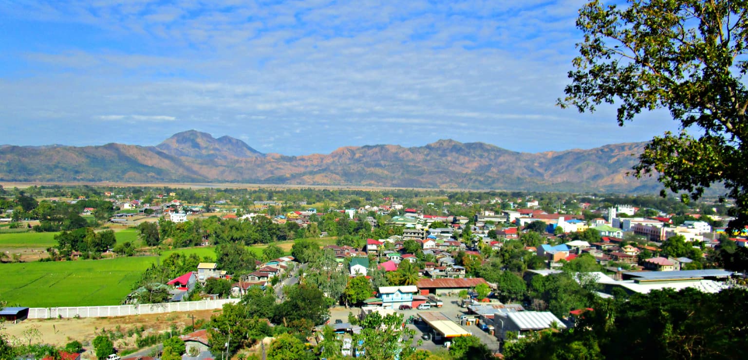
Cassamata Hill National Park is best known for its sweeping panoramic views across the Abra River valley, which encompasses the town of Bangued and stretches between the Cordillera Central and Ilocos mountain ranges. The park's summit provides visitors with a striking view of Mount Banti Goolong, a 990-meter peaks shaped in a way that locals have named the Sleeping Beauty mountain for its resemblance to a reclining figure. The combination of accessible hilltop recreation, cultural landmarks including a Marian shrine, and the dramatic mountain backdrop gives this small park a distinctive character as both a natural viewpoint and a local heritage site.

Cassamata Hill National Park history and protected-area timeline

The Cassamata Hill area was designated as a protected national park in 1974, formally establishing its status within the Philippines' protected areas network. This designation came during a period when the country was expanding its conservation framework to include landscapes that combined ecological, scenic, and recreational values rather than solely pristine wilderness areas. The park's establishment reflected recognition that accessible hilltop areas like Cassamata Hill could serve important functions as nature recreation sites while also preserving cultural features and scenic vistas. Management of the park falls under the joint authority of the national Department of Environment and Natural Resources and the local government of Bangued municipality, combining national conservation policy with local administrative capacity. Over the decades, infrastructure development at the site has added facilities for visitors while maintaining the hilltop's function as a place of scenic and spiritual significance.

Cassamata Hill National Park landscape and geographic character

The landscape of Cassamata Hill National Park is characterized by its elevated position above the Abra River valley, with the hill itself forming a prominent landmark in the regional topography. The hill rises via a winding access road and concrete stairways that allow visitors to ascend to its summit, where Victoria Park provides an open viewpoint. From this vantage point, the landscape spreads outward to reveal the flat to gently rolling valley floor of the Abra River, which has carved a broad corridor through the mountainous terrain of northern Luzon. The valley is bounded on either side by more dramatic mountain terrain: the Cordillera Central range to the east and the Ilocos mountain range to the west. The 990-meter Mount Banti Goolong, commonly called Sleeping Beauty for its silhouette resemblance to a reclining female form, rises as a particularly recognizable peak in the middle distance, adding to the visual drama of the view from the park.

Cassamata Hill National Park ecosystems, habitats, and plant life

The natural character of Cassamata Hill National Park reflects its role as a protected landscape within a predominantly agricultural and settled region of Abra province. While the park is not a primary biodiversity conservation site in the sense of protecting critical habitats for endangered species, it serves important functions as a green space that preserves the hill's natural vegetation and provides ecological connectivity within the local landscape. The park's elevation above the valley floor places it within a transitional zone between lowland agricultural land and the steeper slopes of the surrounding mountains. Trees and vegetation cover the hill slopes and summit area, providing habitat for common bird species and small wildlife while also stabilizing the soil on the hill's slopes.

Cassamata Hill National Park wildlife and species highlights

The wildlife present in Cassamata Hill National Park reflects the park's position as an accessible green space within a populated valley landscape rather than a remote wilderness area. Common bird species native to the Abra region can be found in the park's trees and vegetation, including various songbirds and tropical species adapted to the mix of cleared and forested land. The park's vegetation provides foraging and shelter opportunities for small mammals, while the surrounding agricultural landscape supports populations of common wildlife adapted to human-modified environments. The park's primary wildlife value lies in providing habitat for these adaptable species within an otherwise cultivated valley and in maintaining green space that supports ecological processes in the Bangued area.

Cassamata Hill National Park conservation status and protection priorities

Cassamata Hill National Park holds conservation significance as a Category V protected landscape under the IUCN protected area classification system, recognizing its value in protecting scenic landscapes that combine natural and cultural elements. The park's designation preserves the hilltop's natural vegetation and prevents development that would diminish its scenic integrity or degrade the views over the Abra valley. While not designated primarily for biodiversity protection, the park contributes to the broader conservation network of the Philippines by maintaining natural areas within the Cordillera Administrative Region. The protected status also supports the park's function as a green buffer and recreational space for the municipality of Bangued, providing residents with access to natural surroundings without requiring travel to more remote protected areas.

Cassamata Hill National Park cultural meaning and human context

Cassamata Hill National Park carries cultural significance beyond its natural and recreational functions, primarily through the presence of a shrine to the Virgin Mary at its summit. This religious landmark establishes the hilltop as a place of spiritual importance for local communities, adding a cultural dimension to the park's identity. The park's accessibility from the main road connecting Ilocos Sur and Abra has made it a traditional destination for both recreation and pilgrimage. The local name Sleeping Beauty for Mount Banti Goolong reflects the tradition of naming landscape features after recognizable forms, connecting the natural environment to cultural storytelling. The park also serves as a community gathering space for Bangued residents, with facilities that support local recreation and social activities.

Top sights and standout views in Cassamata Hill National Park

The defining highlights of Cassamata Hill National Park are its panoramic views from the summit at Victoria Park, where visitors can see Bangued town, the Abra River valley, and the dramatic backdrop of Mount Banti Goolong rising between the Cordillera Central and Ilocos mountain ranges. The hill itself is an easy and rewarding climb via either a winding road or concrete stairways, making the viewpoint accessible to visitors of varying fitness levels. The combination of natural scenery, cultural heritage through the Marian shrine, and built recreational facilities including a swimming pool and amphitheater gives the park a multifaceted character. The view of Sleeping Beauty mountain from the summit is particularly noted as a memorable landscape feature that distinguishes this park from other viewpoints in the region.

Best time to visit Cassamata Hill National Park

Cassamata Hill National Park can be visited throughout the year given its location in the tropical climate of northern Luzon. The dry season from approximately November to May generally offers clearer skies and more reliable visibility from the summit viewpoints, making this period particularly suitable for visitors seeking the best panoramic views over the valley and mountains. The wet season from June to October brings increased rainfall and potential cloud cover that may reduce visibility from the hilltop but also adds to the lushness of the park's vegetation. Regardless of season, visiting during weekday mornings typically provides a quieter experience compared to weekend afternoons when local residents frequently use the park's recreational facilities.

Park location guide

Geography guide, regional context, and park location map for Cassamata Hill National Park

Cassamata Hill National Park park geography, regions, and map view in Philippines
Understand where Cassamata Hill National Park sits in Philippines through a broader geographic reading of the surrounding landscape, nearby location context, and its mapped position within the national park landscape.

How Cassamata Hill National Park fits into Philippines

The Philippines, officially the Republic of the Philippines, is an archipelagic nation in Southeast Asia comprising approximately 7,641 islands categorized into three main geographical divisions: Luzon, Visayas, and Mindanao. Located in the western Pacific Ocean, it shares maritime borders with Taiwan, Japan, Palau, Indonesia, Malaysia, Vietnam, and China. Manila serves as the capital city, while Quezon City is the most populated city, both within Metro Manila.

Wider geography shaping Cassamata Hill National Park in Philippines

The Philippines is an archipelagic nation in Southeast Asia, positioned in the western Pacific Ocean. Its islands are bounded by the South China Sea to the west, Philippine Sea to the east, and Celebes Sea to the south. The country shares maritime borders with Taiwan to the north, Japan to the northeast, Palau to the east and southeast, Indonesia to the south, Malaysia to the southwest, Vietnam to the west, and China to the northwest.

Map view of Cassamata Hill National Park

Use this park location map to pinpoint Cassamata Hill National Park in Philippines, understand its exact geographic position, and read its mapped placement within the surrounding landscape more clearly.

Pigeon | © OpenStreetMap contributors

Location context for Cassamata Hill National Park

Abra
Park atlas

Map the surrounding Abra River Valley and Cordillera region's protected landscapes

Discover Nearby National Parks and Protected Areas Beyond Cassamata Hill National Park
After exploring the panoramic views of Cassamata Hill National Park, continue your discovery by browsing other national parks and protected areas across the northern Philippines. Compare diverse conservation landscapes, trace regional park boundaries, and understand the geographic spread of protected territories surrounding the Abra River valley.
National parkIlocos Sur

Northern Luzon Heroes Hill National Park: Coastal Mountain Geography and Protected Landscape Identity

Discover the mapped terrain and forest boundaries of this Philippine national park.

Northern Luzon Heroes Hill National Park offers a detailed look at a unique protected landscape in the Philippines' Ilocos Sur region. Its dramatic coastal mountain geography, characterized by steep forested slopes and ravines, stands apart from the typical flat terrain of the area. This national park serves as a significant mapped natural area, preserving vital forest cover and providing insights into the region's ecological context and landscape diversity.

Area
13.16 km²
Established
1963
IUCN
V
National parkNueva Vizcaya

Bangan Hill National Park: A Protected Landscape within Nueva Vizcaya's Geography

Explore its mapped terrain and cultural significance.

Bangan Hill National Park is a crucial protected area nestled in Nueva Vizcaya, Philippines. This page details its specific geography, including its role as a distinct hill within the broader Cagayan Valley landscape. Users can explore the park's mapped boundaries, understand its role as a national park, and discover the surrounding mountain context of the Caraballo and Cordillera Central ranges. It offers a unique perspective on the region's natural and historical significance, serving as a focal point for protected landscape exploration.

Area
0.139 km²
Established
1995
IUCN
II
National parkPhilippines

Aurora Memorial National Park: A Protected Landscape in the Philippines' Sierra Madre

Explore mapped boundaries and endemic avian habitat.

Aurora Memorial National Park represents a critical conservation area situated within the Philippines' Sierra Madre mountain range. Spanning a significant stretch along the eastern mountain slopes, this national park is characterized by its lowland dipterocarp forest ecosystem, recognized for supporting diverse flora and fauna. It is particularly noted as an Important Bird Area, crucial for endemic species like the Philippine eagle and various other avian populations, highlighting its ecological significance within the archipelago's geography.

Area
56.76 km²
Established
1937
IUCN
V
National parkZambales

Olongapo Naval Base Perimeter National Park: Philippines National Park & Protected Landscape in Zambales

Coastal terrain and historical military land context.

Discover Olongapo Naval Base Perimeter National Park, a protected landscape within Zambales province, Philippines. Established adjacent to the former U.S. Naval Base Subic Bay perimeter, this small national park preserves a unique coastal fringe. Its mapped boundaries offer insights into a transitional zone, serving as a green corridor and protecting a fragment of the region's natural habitat. Explore the distinct geographical and historical significance of this protected area.

Area
0.09 km²
Established
1968
IUCN
V
Scope
Terrestrial
National parkTaiwan

Dongsha Atoll National Park: Taiwan's South China Sea Protected Coral Atoll Landscape

Explore mapped marine geography and vital seagrass ecosystems.

Dongsha Atoll National Park is a protected coral atoll in Taiwan, situated in the northern South China Sea. This national park is distinguished by its circular atoll structure, encompassing extensive shallow reef systems and vital seagrass beds. Its marine geography is central to its identity, supporting diverse aquatic life and serving as a crucial protected landscape for regional ecological connectivity. Users can delve into the mapped context and distinct protected-area characteristics of this unique atoll.

Area
3,537 km²
Established
2007
IUCN
II
National parkTaiwan

South Penghu Marine National Park: A Protected Volcanic Island Landscape in Taiwan's Penghu Archipelago

Mapped marine protected areas and unique geological features.

Discover the unique atlas value of South Penghu Marine National Park, Taiwan's protected national park renowned for its dramatic columnar basalt landforms and extensive coral reef systems. This marine protected area provides critical habitat for diverse species and showcases a rugged island geography shaped by volcanic activity. Explore its mapped boundaries and unique geological formations, including famous sea caves, offering a distinct context for landscape discovery.

Area
358.44 km²
Established
2014
IUCN
II
National parkNantou County

Yushan National Park: Explore Taiwan's Highest Mountain and Alpine Protected Terrain

Mapped geography and dramatic peaks within Nantou County.

Yushan National Park is a crucial protected area in Taiwan, renowned for encompassing the island's highest mountain and a significant portion of the Central Mountain Range. This national park's dramatic geography spans over 103,000 hectares, with two-thirds of its territory lying above 2,000 meters. Its vertical ecological zones, from subtropical forests to alpine environments, offer a rich tapestry of landscapes ideal for atlas-style exploration of protected terrain and mountain peak geography.

Area
1,031.21 km²
Established
1985
IUCN
II
National parkOkinawa Prefecture

Iriomote-Ishigaki National Park: Subtropical Island Geography and Protected Landscape Atlas

Explore the unique terrain and mapped boundaries of this national park.

Dive into the geography of Iriomote-Ishigaki National Park, a protected national park situated in Japan's Okinawa Prefecture. This page provides a detailed atlas view of its characteristic subtropical island terrain, including extensive mangrove forests, distinct limestone karst features, and surrounding marine protected areas. Understand the park's unique landscape and its significance within the broader regional geography for comprehensive exploration.

Area
1,221.5 km²
Established
1972
IUCN
II

Common questions about visiting, size, designation, and location context for Cassamata Hill National Park

Cassamata Hill National Park FAQs for park facts, access, geography, and protected area context
Find quick answers about Cassamata Hill National Park, including protected-area facts, park geography, trail and visitor context, and how the park fits into its surrounding country and regional landscape.
MoriAtlas Explorer

Continue Your Protected Areas Search Across the Global Atlas

Deepen your exploration by continuing the structured search for national parks and protected areas worldwide. Utilize the comprehensive filtering capabilities to compare different conservation landscapes and refine your understanding of global park geography. Discover more about the distribution and characteristics of protected natural areas.

Global natural geography