Mori Atlas logo
National parkFuyot Springs National Park

Discover unique mountain springs, cave systems, and waterfall terrain within the Sierra Madre range.

Fuyot Springs National Park: Philippines National Park Protected Landscape & Map Exploration

Fuyot Springs National Park represents a significant protected landscape nestled within the Sierra Madre mountain range of Isabela Province, Philippines. This atlas entry details the park's unique terrain, characterized by its namesake natural springs emerging from mountain slopes, extensive cave systems, and cascading waterfalls like Pinzal Falls. Understand the park's geographic context and its role as a protected area for landscape and biodiversity discovery.

Mountain parksCave systemsWaterfallsBirdwatchingForest protectionSpring waters

Fuyot Springs National Park

National park

Park overview

Structured park overview, official facts, and landscape profile for Fuyot Springs National Park

Fuyot Springs National Park park facts, protected area profile, and essential visitor context

Review the core facts for Fuyot Springs National Park, including designation, size, terrain, visitor scale, habitats, and operating context in one park-focused overview.

About Fuyot Springs National Park

Fuyot Springs National Park occupies a strategic position in northeastern Luzon, Philippines, within the Sierra Madre mountain range that runs along the eastern coast of the island. The park's location in Isabela Province places it in one of the most ecologically significant regions of the country. Established in 1938, it represents one of the older protected areas in the Philippines, created to preserve the unique mountain ecosystem and its natural springs. The park extends to include portions of the nearby municipality of Tumauini, creating a protected zone that encompasses both forest-covered slopes and the natural water resources that emerge from the mountain terrain. The Ilagan Sanctuary component within the park provides additional protection for specific areas while offering visitor amenities. The proximity to the much larger Northern Sierra Madre Natural Park creates an integrated conservation landscape that protects wildlife corridors and supports biodiversity across a broader ecological network.

Quick facts and research context for Fuyot Springs National Park

Fuyot Springs National Park spans 819 hectares in Isabela Province, Philippines, established on October 8, 1938. The park encompasses the Ilagan Sanctuary and sits on the mountain slopes of the Sierra Madre range near Ilagan City and the municipality of Tumauini. The protected area is managed jointly by the Department of Environment and Natural Resources and the City Government of Ilagan. The park features natural mountain springs, multiple cave systems including Main Cave, Altar Cave and Adventure Cave, and the notable Pinzal Falls. The terrain offers mountain trails, odd rock formations, and habitats that support diverse birdlife, making the area popular for birdwatching activities.

Protection and recognition

Documenting the terrestrial designation history and official conservation framework since 1938

Fuyot Springs National Park Protected Area Designation and History

Established in 1938, Fuyot Springs National Park maintains a documented terrestrial protection status that outlines its official management scope. Mapping official conservation frameworks helps researchers and visitors trace the historical continuity of regional habitat preservation efforts.

Protection details

Protection scope
Terrestrial
Designated year
1938
Transboundary protection
No
Park context

Deeper park guide and search-rich context for Fuyot Springs National Park

Fuyot Springs National Park history, landscape, wildlife, and travel context

Explore Fuyot Springs National Park through its history, landscape character, ecosystems, wildlife, conservation priorities, cultural context, and seasonal travel timing in a structured park guide built for atlas discovery and search intent.

Why Fuyot Springs National Park stands out

Fuyot Springs National Park is best known for its natural mountain springs that give the park its name, combined with its cave systems and waterfall attractions. The park contains several notable caves that offer exploration opportunities for visitors, including Main Cave, Altar Cave, and Adventure Cave. Pinzal Falls provides a scenic waterfall experience within the park boundaries. The mountain slopes of the Sierra Madre range create a distinctive backdrop for hiking and mountaineering activities. The adjacent Northern Sierra Madre Natural Park contains even more diverse wildlife, establishing the broader region as a significant biodiversity area in the Philippines.

Fuyot Springs National Park history and protected-area timeline

Fuyot Springs National Park was established on October 8, 1938 through Proclamation No. 327, making it one of the earliest designated protected areas in the Philippines during the American colonial period. The establishment reflected growing recognition of the need to preserve unique Philippine ecosystems and natural resources. The park's creation specifically aimed to protect the natural springs that emerge from the mountain slopes and the surrounding forest environment. Over the decades, the park has been managed under the jurisdiction of the Department of Environment and Natural Resources, with the City Government of Ilagan playing a collaborative role in its administration. The park was later expanded to include the Ilagan Sanctuary, which now serves as a核心 component offering visitor attractions and educational opportunities about local wildlife and ecosystems.

Fuyot Springs National Park landscape and geographic character

The landscape of Fuyot Springs National Park is defined by its mountain slope location within the Sierra Madre range, the longest mountain range in the Philippines. The terrain features rugged slopes, natural springs that emerge from the hillside, and distinctive rock formations that create visual interest throughout the park. The area includes several cave systems formed within the limestone and volcanic rock of the mountain slopes. Pinzal Falls cascades through the landscape, providing a prominent water feature that visitors can experience. The natural mountain springs that give the park its name flow from various points in the terrain, creating moist microenvironments that support diverse vegetation. The surrounding forest coverage varies from lower elevation tropical forest to higher elevation zones as the terrain rises.

Fuyot Springs National Park ecosystems, habitats, and plant life

The nature of Fuyot Springs National Park reflects its position within the Sierra Madre ecosystem, one of the most biodiverse regions in the Philippines. The park's natural springs create unique aquatic habitats and support riparian vegetation along water courses. The forest environments on the mountain slopes provide habitat for numerous species, particularly bird species that draw birdwatchers to the area. The cave systems within the park contain their own specialized ecosystems adapted to dark conditions. The broader Northern Sierra Madre region is recognized for its exceptional bird diversity, and the park's proximity to this larger protected area means it contributes to a connected conservation network. The elevation gradient from the mountain slopes to the lower areas creates diverse microclimates and habitat zones within the protected area.

Fuyot Springs National Park wildlife and species highlights

Fuyot Springs National Park supports wildlife populations characteristic of the Sierra Madre region, with particular significance for bird species that thrive in the forest environments. The park attracts birdwatchers seeking to observe both resident and migratory species that inhabit the area. The forest-covered slopes provide habitat for various mammal and reptile species adapted to the tropical mountain environment. The cave systems within the park may support specialized species including bats and other cave-dwelling organisms. The adjacent Northern Sierra Madre Natural Park contains even more diverse wildlife, and the protected area network supports wildlife corridors that allow species movement between areas. The park's varied elevation and habitat types create conditions supporting ecological diversity.

Fuyot Springs National Park conservation status and protection priorities

Fuyot Springs National Park holds IUCN Category V classification as a protected landscape and seascape, reflecting its role in preserving both natural values and the cultural landscape of the region. The protected area status helps safeguard the mountain ecosystem, natural springs, and forest environments from development pressures. The park functions as part of a larger conservation network connected to the Northern Sierra Madre Natural Park, creating an integrated approach to protecting the region's biodiversity. Management involves both national government agencies through the Department of Environment and Natural Resources and local governance through the City Government of Ilagan. The protected status helps preserve wildlife habitats, watershed areas that supply water to surrounding communities, and the natural springs that define the park's character.

Fuyot Springs National Park cultural meaning and human context

Fuyot Springs National Park is located within Ilagan City, the capital of Isabela Province, and the park's establishment has historical ties to the broader development of the region. The park lies near the municipality of Tumauini, extending the protected area into a neighboring jurisdiction. Local communities have traditional connections to the mountain landscape and its resources, with the natural springs having cultural significance for surrounding populations. The park's recreation facilities and attractions support local tourism and provide economic benefits to the area. The celebration of Ilagan's founding anniversary, which has included events within the park such as the inauguration of the zipline, reflects the integration of the protected area into community identity and cultural activities.

Top sights and standout views in Fuyot Springs National Park

The natural mountain springs that define Fuyot Springs National Park remain the park's signature feature, providing both ecological importance and visitor attraction. Pinzal Falls offers a prominent waterfall experience within the park boundaries. The cave systems, including Main Cave, Altar Cave and Adventure Cave, provide spelunking and exploration opportunities unique to the protected area. The zipline attraction inaugurated in 2012 adds adventure recreation options for visitors. The Ilagan Sanctuary component offers additional visitor amenities including a mini-zoo, butterfly park, natural spring water pool and ATV rides. The park's position within the Sierra Madre range provides scenic mountain hiking and mountaineering opportunities. Birdwatching is a significant draw, with the park's diverse habitats supporting numerous avian species.

Best time to visit Fuyot Springs National Park

The park can be visited throughout the year, though the dry season from November to April generally offers more comfortable conditions for outdoor activities and hiking. The wet season from May to October brings increased rainfall to the region, which can affect trail conditions and visibility but also ensures the waterfalls and springs maintain strong water flow. The cooler months from December to February may provide more comfortable temperatures for strenuous activities like hiking and mountaineering. Birdwatching opportunities exist year-round, though migratory species may be more prevalent during certain seasons. Visitors planning cave explorations should consider that some caves may have restrictions during periods of heavy rainfall due to flooding risks.
Monthly climate preview

Trace the long-term temperature patterns and precipitation trends of this protected landscape.

Fuyot Springs National Park Climate and Monthly Average Weather Normals

Long-term observations at a representative elevation of 133 meters show average temperatures peaking in May, with daily rainfall reaching its highest levels late in the calendar year. Analyzing the complete twelve-month profile offers a detailed look at temperature ranges and daily precipitation trends across the park landscape.
Annual mean26 °C
23 °C28 °C
Jan23°
Feb24°
Mar26°
Apr28°
May28°
Jun28°
Jul27°
Aug27°
Sep27°
Oct26°
Nov25°
Dec24°
Warmest month
May

28.4 °C

Coolest month
January

22.8 °C

Wettest month
November

10.5 mm/day

Driest month
March

2.7 mm/day

Park location guide

Geography guide, regional context, and park location map for Fuyot Springs National Park

Fuyot Springs National Park park geography, regions, and map view in Philippines

Understand where Fuyot Springs National Park sits in Philippines through a broader geographic reading of the surrounding landscape, nearby location context, and its mapped position within the national park landscape.

How Fuyot Springs National Park fits into Philippines

The Philippines, officially the Republic of the Philippines, is an archipelagic nation in Southeast Asia comprising approximately 7,641 islands categorized into three main geographical divisions: Luzon, Visayas, and Mindanao. Located in the western Pacific Ocean, it shares maritime borders with Taiwan, Japan, Palau, Indonesia, Malaysia, Vietnam, and China. Manila serves as the capital city, while Quezon City is the most populated city, both within Metro Manila.

Wider geography shaping Fuyot Springs National Park in Philippines

The Philippines is an archipelagic nation in Southeast Asia, positioned in the western Pacific Ocean. Its islands are bounded by the South China Sea to the west, Philippine Sea to the east, and Celebes Sea to the south. The country shares maritime borders with Taiwan to the north, Japan to the northeast, Palau to the east and southeast, Indonesia to the south, Malaysia to the southwest, Vietnam to the west, and China to the northwest.

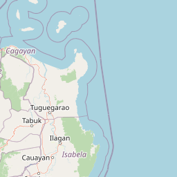
Map view of Fuyot Springs National Park

Use this park location map to pinpoint Fuyot Springs National Park in Philippines, understand its exact geographic position, and read its mapped placement within the surrounding landscape more clearly.

Pigeon | © OpenStreetMap contributors
Park atlas

Map the regional protected-area geography and park context near Fuyot Springs National Park.

Compare National Parks and Protected Areas Near Fuyot Springs National Park

Browse other national parks and protected areas located geographically close to Fuyot Springs National Park within the Sierra Madre region of the Philippines. Expand your atlas discovery of connected conservation landscapes, comparing terrain, features, and ecological significance across the broader area.
Protected landscapeQuirino
About 80 km away#1 closest

South

Quirino Protected Landscape: Exploring the Sierra Madre and Cagayan River Watershed

Mountainous forest geography in the province of Quirino

Spanning roughly two thirds of the province of Quirino, this protected landscape is a strategic natural feature of northern Luzon. Defined by the confluence of the Sierra Madre and Caraballo mountain ranges, it serves as a massive reservoir for the Upper Cagayan River. The terrain consists of dense rainforest ridges, deep river valleys, and isolated peaks, playing a central role in regional biodiversity and watershed conservation.

Area
1,759.44 km²
Established
2004
IUCN
V
Relief
Mountain
Protected landscapeAurora
About 99 km away#2 closest

South

Talaytay Protected Landscape: Geography and Protected Area Mapping in Aurora Province

Sierra Madre mountain-to-coast watershed exploration

Analyze the topographic profile and protected boundaries of Talaytay Protected Landscape. This reserve serves as a significant ecological corridor in Aurora, connecting the Sierra Madre interior to the Pacific coast through a series of forested riverine valleys and steep mountain slopes.

Area
35.26 km²
Established
2000
IUCN
V
Relief
Mountain
National parkCordillera Administrative Region
About 100 km away#3 closest

Northwest

Balbalasang, Balbalan National Park: Mapped Protected Area in Cordillera Administrative Region

Explore its national park geography and landscape context.

Balbalasang, Balbalan National Park offers a distinct protected landscape within the Philippines' Cordillera Administrative Region. This canonical detail page provides an atlas-driven perspective, focusing on the park's mapped boundaries and its regional geographic context. Users can delve into the specific terrain and natural features that define this national park, enhancing their understanding of its protected area status and its significance in landscape exploration.

Area
13.38 km²
Established
1972
IUCN
II
Relief
Mountain
National parkNueva Vizcaya
About 102 km away#4 closest

Southwest

Bangan Hill National Park: A Protected Landscape within Nueva Vizcaya's Geography

Explore its mapped terrain and cultural significance.

Bangan Hill National Park is a crucial protected area nestled in Nueva Vizcaya, Philippines. This page details its specific geography, including its role as a distinct hill within the broader Cagayan Valley landscape. Users can explore the park's mapped boundaries, understand its role as a national park, and discover the surrounding mountain context of the Caraballo and Cordillera Central ranges. It offers a unique perspective on the region's natural and historical significance, serving as a focal point for protected landscape exploration.

Area
0.139 km²
Established
1995
IUCN
II
Relief
Mixed relief
Protected landscapeAurora
About 105 km away#5 closest

South

Simbahan-Talagas Protected Landscape: Geographic Profile and Sierra Madre Forest Mapping

An essential watershed and dipterocarp habitat in Aurora province.

Analyze the protected boundaries and hydrological features of the Simbahan-Talagas Protected Landscape. This region features a dense network of river systems and continuous dipterocarp forest cover that extends across the eastern foothills of the Sierra Madre mountain range in Luzon.

Area
22.66 km²
Established
2000
IUCN
V
Relief
Mountain
National parkMountain Province
About 123 km away#6 closest

West

Mount Data National Park: A Protected Highland Watershed in the Mountain Province

Analyzing the topography and mapped forest boundaries of the Cordillera Central

Mount Data National Park serves as a vital protected area in the northern Philippines, anchoring the headwaters of the Agno, Abra, and Rio Chico river systems. This highland site offers a distinct look at the ridge-focused geography of the Cordillera Central, characterized by high-elevation terrain and a long-standing contribution to scientific research on Philippine mammal diversity.

Area
33.52 km²
Established
1936
Relief
Mountain
Scope
Terrestrial
National parkPhilippines
About 125 km away#7 closest

West

Mount Data National Park: Protected Montane Watershed and Philippine Mountain Geography

High elevation forest terrain and regional watershed context.

Located in the Cordillera Central, Mount Data National Park represents a historic protected area of the Philippines. Its montane ecosystems, ranging from pine forests to mossy oak stands, sustain vital downstream river systems while supporting unique biodiversity. This atlas entry provides geographic insights into its steep ridges, forested slopes, and the broader environmental significance of its high-elevation terrain.

Area
55.13 km²
Established
1936
Relief
Mountain
Scope
Terrestrial
Protected landscapeBenguet
About 150 km away#8 closest

Southwest

Upper Agno River Basin Resource Reserve: Mapping the Benguet Watershed Protected Landscape

High-elevation forest, river catchment, and Cordillera peaks

Spanning from the Mount Data area to the Binga Dam, this reserve serves as a pivotal hydropower catchment and mountain sanctuary. Explore the geographic extent of these pine-clad slopes, mossy dwarf forests, and high-altitude grasslands that define the southern Cordillera landscape.

Area
775.61 km²
Established
1966
IUCN
VI
Relief
Mountain

Common questions about visiting, size, designation, and location context for Fuyot Springs National Park

Fuyot Springs National Park FAQs for park facts, access, geography, and protected area context

Find quick answers about Fuyot Springs National Park, including protected-area facts, park geography, trail and visitor context, and how the park fits into its surrounding country and regional landscape.
MoriAtlas Explorer

Continue Your Protected Areas Search Across the Global Atlas

Deepen your exploration by continuing the structured search for national parks and protected areas worldwide. Utilize the comprehensive filtering capabilities to compare different conservation landscapes and refine your understanding of global park geography. Discover more about the distribution and characteristics of protected natural areas.

Global natural geography