Mori Atlas logo
National parkOti-Kéran National Park

Explore the mapped boundaries and geographic context of Oti-Kéran National Park in the Kara Region.

Oti-Kéran National Park: Discover Togo's Premier National Park and Protected Savanna Landscape

(Parc National de la Oti-Kéran)

Oti-Kéran National Park represents a vital national park within Togo's Kara Region, serving as a protected savanna ecosystem of approximately 690 square kilometers. This park is a crucial element of the WAP transfrontier conservation landscape, characterized by its wooded savanna plains, riparian corridors, and Ramsar-designated wetland habitats. Understanding Oti-Kéran National Park means engaging with its unique sudanian zone geography and its role as a protected area vital for regional wildlife migration and bird diversity within West Africa's atlas.

National parkSavanna ecosystemRamsar siteImportant Bird AreaWest AfricaTransfrontier conservation

Oti-Kéran National Park

National park

Park overview

Structured park overview, official facts, and landscape profile for Oti-Kéran National Park

Oti-Kéran National Park park facts, protected area profile, and essential visitor context

Review the core facts for Oti-Kéran National Park, including designation, size, terrain, visitor scale, habitats, and operating context in one park-focused overview.

About Oti-Kéran National Park

Oti-Kéran National Park represents Togo's principal protected area in the northern savanna zone, encompassing a landscape of semi-deciduous woodland, wooded savanna, and seasonal floodplains. The park's location in the sudanian biogeographic region places it at a critical juncture between the forest zone to the south and the more arid sahelian zone to the north, supporting a mixture of species from both regions. The Oti River and its tributaries traverse the park, creating riparian corridors and wetland areas that serve as crucial dry-season refuges for wildlife. Following boundary reforms in 1999, the park was reduced from approximately 179,550 hectares to its current 69,000 hectares as peripheral degraded areas were excised for human development. The park remains threatened by ongoing human settlement, agricultural expansion particularly cotton farming, charcoal production, and illegal grazing within its boundaries. Despite these pressures, the protected area retains significant ecological value and serves as a potential wildlife corridor connecting the Togolese protected area network to the broader WAP complex across neighboring countries.

Quick facts and research context for Oti-Kéran National Park

Oti-Kéran National Park covers 690 square kilometers in northern Togo, situated in the Kara Region and Savannes Region near the border with Burkina Faso. The park was established in 1950 and additionally designated as a Ramsar Wetland in 1995. It lies within the sudanian savanna zone of West Africa and forms part of a planned biosphere reserve linked to the broader WAP (W-Arly-Pendjari) transfrontier protected area network spanning Burkina Faso, Benin, and Niger. The park is recognized as an Important Bird Area by BirdLife International, with approximately 214 bird species recorded.

Protection and recognition

Documented designation history and terrestrial conservation scope in Togo

Oti-Kéran National Park Protection Status and Conservation Profile

Researchers and conservationists can explore the formal terrestrial designation history of Oti-Kéran National Park dating back to its establishment in 1995. Verified data records and administrative scopes clarify the official frameworks governing the park's terrestrial boundaries and regional conservation status.

Protection details

Protection scope
Terrestrial
Designated year
1995
Transboundary protection
No
Park context

Deeper park guide and search-rich context for Oti-Kéran National Park

Oti-Kéran National Park history, landscape, wildlife, and travel context

Explore Oti-Kéran National Park through its history, landscape character, ecosystems, wildlife, conservation priorities, cultural context, and seasonal travel timing in a structured park guide built for atlas discovery and search intent.

Why Oti-Kéran National Park stands out

Oti-Kéran National Park is best known as Togo's largest protected savanna area and a key component of the WAP transfrontier conservation landscape. The park is particularly notable for its bird diversity, supporting significant populations of species including the black crowned crane, goliath heron, and pink-backed pelican. Historically, the park was famous for its elephant populations, which were a major ecotourism attraction in the 1980s before near-complete extirpation during the conflicts of the 1990s. The park also contains important wetland habitats recognized under the Ramsar Convention.
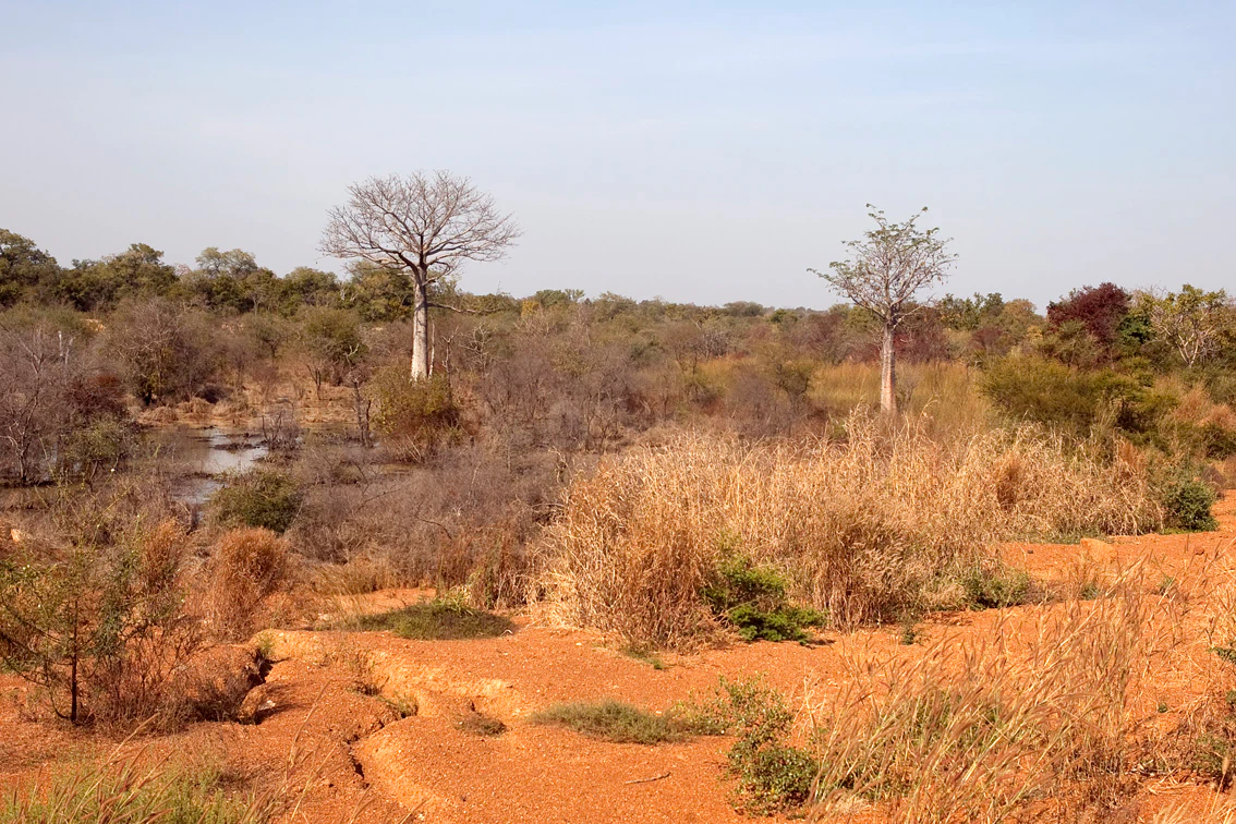
Dry savanna landscape with reddish soil, scattered acacia trees, tall grasses, and a small water body under a clear sky.
Scenic dry savanna landscape of Oti-Kéran National Park with reddish soil, scattered acacia trees, and a small water body.

Oti-Kéran National Park history and protected-area timeline

Oti-Kéran National Park was established in 1950 as part of Togo's earliest protected area network. Throughout the 1960s and 1970s, the park and surrounding reserves in northern Togo were significantly expanded, though this expansion occurred without the consent or participation of local communities. Local populations were displaced from their lands and lost access to agricultural areas, resulting in increased poverty and food insecurity in surrounding villages. Additionally, wildlife from the protected but unfenced areas, particularly elephants, caused significant damage to crops and fields, generating resentment among local communities toward both the protected areas and the wildlife they contained. During the political turmoil of 1990, these tensions erupted into widespread violence against protected areas, with mass slaughter of wildlife and destruction of infrastructure. Following this period of upheaval, the Togolese government initiated boundary reforms beginning in 1999, excluding severely degraded peripheral areas from the national park and reclassifying them for human development. This reduced the park's area by more than half. Prior to the 1990s conflicts, the park had developed a well-regarded ecotourism sector with infrastructure including a hotel, roads, and observation platforms, generating significant revenue. Today, this infrastructure lies in ruins and the park's tourism sector has not recovered.

Oti-Kéran National Park landscape and geographic character

The park occupies a landscape of gentle savanna plains with scattered woodland and riparian forests along watercourses. The terrain is largely flat to slightly undulating, typical of the sudanian plateau. The Oti River and its seasonal tributaries create corridors of denser vegetation that stand in contrast to the surrounding savanna, providing important habitat diversity. The park includes seasonal wetlands and floodplain areas that fill during the rainy season and contract dramatically during the dry months, creating a dynamic landscape. The vegetation consists primarily of wooded savanna with species such as shea, baobab, and various acacia species, transitioning to more dense gallery forests along watercourses. The landscape provides open vistas across savanna horizons with scattered tree islands, characteristic of the West African sudanian zone.

Oti-Kéran National Park ecosystems, habitats, and plant life

Oti-Kéran National Park sits within the sudanian biogeographic region, a zone characterized by distinct wet and dry seasons and vegetation adapted to seasonal rainfall patterns. The park's ecosystem includes woodland savanna, riparian forest, and seasonal wetland habitats that together support considerable biodiversity despite historical disturbances. The protected area functions as an important link in the broader WAP transfrontier ecosystem, which represents one of West Africa's most significant remaining contiguous savanna protected landscapes. The Ramsar designation recognizes the importance of the park's wetland habitats for waterbird conservation and broader ecological processes. The riparian corridors along the Oti River and its tributaries are particularly ecologically significant, providing refuge for species during the dry season and serving as wildlife movement corridors.

Oti-Kéran National Park wildlife and species highlights

The park supports diverse wildlife, though populations have been significantly reduced since the 1990s conflicts. Mammal species recorded include olive baboon, tantalus monkey, patas monkey, kob, waterbuck, red-flanked duiker, common duiker, African buffalo, hippopotamus, and warthog. The African elephant, once a common sighting and major tourism attraction, was likely nearly extirpated during the 1990s, though sporadic migrating individuals are occasionally reported and conservation efforts aim to reestablish a small population. West African lions have been reported sporadically but there is no permanent population in Togo. The park is designated as an Important Bird Area by BirdLife International due to its significant bird populations, with approximately 214 species recorded including black crowned crane, goliath heron, grey heron, pink-backed pelican, violet turaco, and numerous weaver bird and finch species. Reptiles include the West African crocodile.

Oti-Kéran National Park conservation status and protection priorities

Oti-Kéran National Park holds significant conservation importance as Togo's largest protected savanna area and a key component of the planned WAP transfrontier biosphere reserve. The Ramsar Wetland designation in 1995 recognizes the international importance of the park's wetland ecosystems. The park is designated as an Important Bird Area, acknowledging its significance for bird conservation. However, the park faces substantial ongoing threats from human encroachment including settlement, cotton agriculture, charcoal production, and illegal grazing. The reduction in park boundaries following 1999 reforms reflects both the extent of historical degradation and the competing pressures for land use. Conservation efforts including a UNDP project aim to reestablish elephant populations and restore habitats, but the park's ecological recovery remains challenging amid persistent human pressures.

Oti-Kéran National Park cultural meaning and human context

The park exists within a landscape historically inhabited by farming communities whose lands were incorporated into the protected area during expansion phases in the 1960s and 1970s. This history of displacement without consent created lasting tensions between conservation objectives and local livelihoods. The local population traditionally practiced agriculture and had close interactions with the landscape, which now falls within protected boundaries. These historical dynamics continue to influence community relationships with the park and present challenges for effective conservation that balances ecological objectives with local community needs.

Top sights and standout views in Oti-Kéran National Park

As Togo's largest northern protected area, Oti-Kéran offers access to sudanian savanna ecosystems with potential for wildlife observation and birdwatching in a relatively undeveloped setting. The park's position within the WAP transfrontier network provides potential for regional conservation联动. The Ramsar-designated wetlands support diverse waterbird populations. The riparian forests along the Oti River provide scenic landscape diversity. The park's history as a former regional ecotourism model, though now in ruins, indicates the landscape's inherent tourism potential. The ongoing conservation efforts to restore elephant populations represent a long-term vision for ecological recovery.

Best time to visit Oti-Kéran National Park

The optimal time to visit Oti-Kéran National Park is during the dry season from November to April, when wildlife concentrates around remaining water sources and visibility is improved in the thinner vegetation. The wet season from May to October brings challenging road conditions and reduced wildlife visibility as animals disperse more widely across the landscape. However, the wet season transforms the landscape with lush vegetation and is particularly rewarding for birdwatching when migratory species are present. The park's infrastructure is limited and access can be difficult year-round, so visitors should plan accordingly and be prepared for basic conditions.

Monthly climate preview

Analyzing three decades of temperature averages and daily precipitation patterns in the Kara Region

Monthly Weather Normals and Climate Profile of Oti-Kéran National Park

Long-term data from a representative coordinate at 172.13 meters elevation shows a distinct cycle where mean temperatures peak above 30 degrees Celsius in March before the wettest interval peaks in August. Accessing the complete monthly climate profile details the transition from dry, hot periods to the rainier intervals across Oti-Kéran National Park.
Annual mean27 °C
25 °C31 °C
Jan25°
Feb28°
Mar31°
Apr30°
May29°
Jun27°
Jul26°
Aug26°
Sep26°
Oct27°
Nov26°
Dec25°
Warmest month
March

30.6 °C

Coolest month
December

24.9 °C

Wettest month
August

8.8 mm/day

Driest month
December

0 mm/day

Park location guide

Geography guide, regional context, and park location map for Oti-Kéran National Park

Oti-Kéran National Park park geography, regions, and map view in Togo

Understand where Oti-Kéran National Park sits in Togo through a broader geographic reading of the surrounding landscape, nearby location context, and its mapped position within the national park landscape.

How Oti-Kéran National Park fits into Togo

Togo, officially the Togolese Republic, is a narrow West African nation stretching from the Gulf of Guinea to Burkina Faso. It was colonized by Germany in 1884, transferred to France after World War I, and gained independence in 1960. The country has a population of approximately 9.6 million people across an area of about 56,785 km².

Wider geography shaping Oti-Kéran National Park in Togo

Togo is located in West Africa, extending north from the Gulf of Guinea along a narrow coastal strip. It is bordered by Ghana to the west, Benin to the east, and Burkina Faso to the north. The country has a width of less than 115 km between Ghana and Benin. The terrain rises from a coastal plain to an interior plateau.

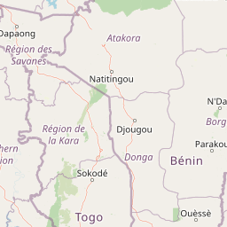
Map view of Oti-Kéran National Park

Use this park location map to pinpoint Oti-Kéran National Park in Togo, understand its exact geographic position, and read its mapped placement within the surrounding landscape more clearly.

Pigeon | © OpenStreetMap contributors

Location context for Oti-Kéran National Park

Kara Region

A Visual Atlas of West Africa's Sudanian Zone, Revealing Oti-Kéran's Diverse Woodland Habitats and Riverine Terrain

Oti-Kéran National Park Photography: Explore Togo's Savanna Landscapes and Protected Area Scenery

Browse imagery to understand Oti-Kéran National Park's distinct landscapes, from its expansive savanna plains and scattered woodlands to the vital riparian forests along the Oti River. These visual records provide essential geographic context, detailing the park's dynamic wetland features, sudanian ecosystem, and the protected habitats characterizing this significant West African conservation area.

Dry savanna landscape with reddish soil, scattered acacia trees, tall grasses, and a small water body under a clear sky.

Park atlas

Compare protected savanna ecosystems, regional wetlands, and connected transfrontier landscapes in the broader West African sudanian zone.

Explore Nearby National Parks and Protected Areas Around Oti-Kéran National Park

Continue your park atlas discovery from Oti-Kéran National Park by exploring other national parks and protected areas across Togo, tracing connected savanna ecosystems and regional wetland landscapes. This geographic view allows for direct comparison of conservation challenges and natural habitats within the broader West African sudanian zone.
National parkSavanes Region
About 80 km away#1 closest

Northwest

Fosse aux Lions National Park: National Park Exploration in Togo's Savanes Region

Mapped protected area geography and landscape context.

Fosse aux Lions National Park represents a distinct protected landscape within the Savanes Region of Togo. This entry focuses on its identity as a national park, providing structured information on its geographic placement and mapped boundaries. It serves as a core element for understanding the distribution of protected areas and the specific natural terrain within this region of Togo, aiding in comprehensive atlas-style exploration.

Area
16.5 km²
Established
1954
IUCN
II
Relief
Lowland
Protected areaKompienga Province
About 104 km away#2 closest

North

Lac de la Kompienga: Geography and Mapped Protected Landscapes in Kompienga Province

A landmark hydroelectric reservoir and wetland habitat

Lac de la Kompienga constitutes a primary water resource and ecological site within the dry savanna of Burkina Faso. This artificial reservoir creates a vital wetland mosaic, supporting diverse aquatic birdlife and fisheries while functioning as a critical component of the regional Volta Basin hydrology. The site captures the transition between engineered water management and the natural dry woodland ecosystems characteristic of the Est Region.

Area
175.45 km²
Established
1988
Relief
Lowland
Scope
Terrestrial
National parkBenin
About 117 km away#3 closest

Northeast

Pendjari National Park: Mapping Benin's Primary Protected Savanna Ecosystem and Wilderness

Located in northwestern Benin, bordering the WAP transboundary complex.

Pendjari National Park represents a significant conservation landscape in West Africa, featuring a complex geography of river-fed riparian forests, sprawling savanna plains, and the high-elevation cliffs of the Atakora mountain range. This protected area offers a look into an intact savanna wilderness, serving as a vital sanctuary for large mammals and diverse bird species within its clearly defined boundaries.

Area
2,755 km²
IUCN
II
Relief
Highland
Climate
Subtropical
National parkAtacora Department
About 117 km away#4 closest

Northeast

Parc national de la Pendjari: Geographic Atlas and Protected Area Overview in Atacora Department

Savanna plains and quartzite mountain ridges in West Africa

Parc national de la Pendjari represents an ecologically vital protected landscape in the Atacora Department of Benin. This atlas overview details its complex geography, ranging from the flat sandstone peneplain to the permanent waters of the Pendjari River. Learn how these boundaries support one of the most significant contiguous savanna ecosystems in West Africa, featuring diverse habitats from gallery forests to open woodlands.

Area
4,700 km²
Established
1961
IUCN
II
Visitors
7K annual
National parkTogo
About 139 km away#5 closest

South

Fazao-Malfakassa National Park: Togo's Expansive Protected Mountainous Terrain and Forest Refuge

Explore a unique West African national park with diverse ecosystems and vital conservation importance.

Fazao-Malfakassa National Park stands as Togo's largest national park, a protected expanse of mountainous terrain in the eastern highlands crucial for regional conservation. This wilderness area shelters significant forest ecosystems and serves as a vital watershed, contributing to the ecological integrity of West Africa. Its diverse landscape, characterized by rugged ridges and valleys, offers a unique insight into Togo's protected natural heritage and its role as a biodiversity corridor.

IUCN
II
Scope
Terrestrial
National parkTapoa Province
About 178 km away#6 closest

Northeast

Arli National Park National Park: Mapped Protected Landscape in Tapoa Province

Explore its geographic context and boundaries.

Arli National Park stands as a critical protected area, identified as a national park within Tapoa Province. This detail page serves as an atlas-focused entry point to understanding the park's unique landscape characteristics and its precise geographic location. Users can investigate its mapped boundaries and explore how it fits into the regional geography, offering a foundational understanding for protected-area discovery.

Area
760 km²
Established
1954
IUCN
IV
Relief
Upland
National parkNiger
About 192 km away#7 closest

Northeast

W National Park: Niger National Park, UNESCO World Heritage Site & Ramsar Wetland

Transborder savanna ecosystem and dramatic Niger River landscape.

W National Park in Niger offers a unique atlas view of a vast protected landscape defined by the Niger River's iconic W-shaped bend. As a UNESCO World Heritage Site and Ramsar Wetland, it protects crucial savanna plains, extensive floodplains, and rocky outcrops. This transborder conservation area is a vital habitat for West African wildlife, providing a rich context for geographic discovery and landscape exploration.

Area
10,000 km²
Established
1954
IUCN
II
Relief
Mixed relief
National parkOti Region
About 197 km away#8 closest

South

Kyabobo National Park: Ghana's Highland National Park with Mount Dzebobo and Forest-Savanna Transition

Explore mountainous terrain, park boundaries, and regional geography in Oti Region.

Kyabobo National Park is a significant protected landscape in Ghana's Oti Region, celebrated for its mountainous topography and the commanding presence of Mount Dzebobo. This national park, established in 1993, safeguards a critical ecological transition zone featuring diverse habitats from dense forests to open tree savanna. Its unique geography and protected status make it a vital site for understanding regional conservation and atlas-based landscape exploration in West Africa, offering insights into varied terrain and ecosystems.

Area
360 km²
Established
1993
IUCN
II
Relief
Mountain

Common questions about visiting, size, designation, and location context for Oti-Kéran National Park

Oti-Kéran National Park FAQs for park facts, access, geography, and protected area context

Find quick answers about Oti-Kéran National Park, including protected-area facts, park geography, trail and visitor context, and how the park fits into its surrounding country and regional landscape.
MoriAtlas Explorer

Continue Your Protected Areas Search Across the Global Atlas

Deepen your exploration by continuing the structured search for national parks and protected areas worldwide. Utilize the comprehensive filtering capabilities to compare different conservation landscapes and refine your understanding of global park geography. Discover more about the distribution and characteristics of protected natural areas.

Global natural geography