

Mori Atlas logo
National parkMaiko National Park

Discover the mapped boundaries and pristine rainforest terrain of this critical national park.

Maiko National Park: A Vital Protected Landscape in the Democratic Republic of the Congo

(Parc national de la Maiko)

Maiko National Park represents a significant expanse of pristine tropical rainforest within the Democratic Republic of the Congo, covering approximately 10,885 square kilometers. Established in 1970, this national park is a vital refuge in the Ituri Rainforest ecosystem, characterized by its remote location and extensive river systems. The park's remarkable conservation importance lies in its role as a sanctuary for critically endangered endemic species, including Grauer's gorilla, the okapi, and the Congo peafowl, making its protected landscape a cornerstone of central African biodiversity.

Lowland RainforestEndemic SpeciesGorilla ConservationOkapi HabitatImportant Bird AreaCongo Basin

Maiko National Park

National park

Park overview

Structured park overview, official facts, and landscape profile for Maiko National Park

Maiko National Park park facts, protected area profile, and essential visitor context

Review the core facts for Maiko National Park, including designation, size, terrain, visitor scale, habitats, and operating context in one park-focused overview.

About Maiko National Park

Maiko National Park stands as a testament to both the ecological richness and the complex conservation challenges present in the Democratic Republic of the Congo. Covering nearly 11,000 square kilometers of contiguous tropical forest, the park occupies a strategically important position within the Congo Basin, the world's second-largest tropical rainforest. The park's three-sector structure spans administrative boundaries, integrating the northern reaches of the Ituri Rainforest with more varied terrain to the east and south. Rivers originating from the surrounding hills traverse the park, providing critical water resources and habitat corridors for aquatic species. The region's remoteness has historically insulated much of the forest from intensive human development, though this same isolation has created governance challenges. The park's establishment in 1970 represented a formal recognition of the area's ecological significance, building upon earlier colonial-era protections that focused on the Bakumu region and its indigenous communities. Today, Maiko faces the dual challenge of maintaining ecological integrity while addressing threats from illegal activities and limited resources.

Quick facts and research context for Maiko National Park

Maiko National Park encompasses roughly 10,885 km² of contiguous lowland rainforest in northeastern Democratic Republic of the Congo, making it one of the largest national parks in the country. The park was formally established in 1970 under Presidential Decree 70-312, building upon the earlier Bakumu Hunting Reserve created by Belgian colonial authorities in 1949. The landscape is characterized by tall, closed evergreen rainforest with patches of secondary forest around settlements, receiving high rainfall with peak precipitation in October and November. The eastern sector maintains relatively flat terrain at approximately 1,000 meters elevation, while the northern sector forms part of the larger Ituri Rainforest. The park is governed by the Institut Congolais pour la Conservation de la Nature and has been designated as an Important Bird Area by BirdLife International.

Protection and recognition

Analyzing the documented 1970 terrestrial framework and global conservation records.

Maiko National Park Protected Area Designation and Terrestrial Status

Geographic records outline the terrestrial conservation framework of Maiko National Park, establishing its formal status within the World Database on Protected Areas. Reviewing the official 1970 designation timeline provides critical geographic context for understanding the long term management scope of the protected equatorial forest landscape.

Protection details

Protection scope
Terrestrial
Designated year
1970
Transboundary protection
No
WDPA ID
1080
Park context

Deeper park guide and search-rich context for Maiko National Park

Maiko National Park history, landscape, wildlife, and travel context

Explore Maiko National Park through its history, landscape character, ecosystems, wildlife, conservation priorities, cultural context, and seasonal travel timing in a structured park guide built for atlas discovery and search intent.

Why Maiko National Park stands out

Maiko National Park is renowned for harboring three of the Democratic Republic of the Congo's most iconic endemic species: Grauer's gorilla (eastern lowland gorilla), the okapi, and the Congo peafowl. These species represent the park's extraordinary conservation significance, as each faces severe threats across their remaining range. The park also supports significant populations of African forest elephants, eastern chimpanzees, and the rare aquatic genet, making it a critical refuge for central African forest biodiversity. The combination of these flagship species, combined with the park's vast intact forest habitat, positions Maiko as one of the most important conservation areas in the Congo Basin.

Maiko National Park history and protected-area timeline

The conservation history of Maiko National Park traces back to the Belgian colonial period, when the Bakumu Hunting Reserve was established in 1949 on lands inhabited by the Bakumu people, known locally as "The Kumus." Notably, the original rationale for protecting this area focused more on preventing mineral resource exploitation than on wildlife preservation. The modern protected area emerged on November 20, 1970, when President Joseph Désiré Mobutu signed Presidential Decree 70-312, which incorporated the park into the national protected area network under the legal framework established the previous year. Following the Simba Rebellion of 1964, the park's remote character made it an attractive retreat for rebel groups, and these elements have remained in the region, engaging in poaching and controlling illegal mining operations. This security situation has severely constrained park management, with the ICCN forced to support military operations against rebels and survey teams attacked between 2003 and 2005. International conservation organizations began systematic exploration in 1989, with the Wildlife Conservation Society conducting extensive surveys supported by the World Bank, European Community, and WWF. Subsequent surveys in 2005 and 2006 revealed concerning population trends, and a 2010 survey documented the extinction of a newly discovered gorilla subpopulation, highlighting the intense hunting pressure from miners.

Maiko National Park landscape and geographic character

The physical landscape of Maiko National Park is defined by extensive lowland tropical rainforest with remarkable topographic variation across its three sectors. The northern sector comprises the southern extent of the Ituri Rainforest, one of the most biodiverse forest blocks in central Africa, characterized by tall, closed-canopy evergreen forest with emergent trees reaching impressive heights. The eastern sector presents a relatively flat terrain at approximately 1,000 meters elevation, extending to the Lindi River valley where the landscape begins to transition. Moving farther east, elevation increases as the terrain rises toward hills that mark the park's boundaries. Multiple rivers originate from these elevated areas, flowing northward, eastward, and southward through the forest, creating complex drainage patterns and providing critical aquatic habitat. The vegetation throughout the park consists primarily of primary rainforest, though patches of secondary forest have developed around historical settlement areas. The landscape supports a complex mosaic of forest types responding to local soil conditions, drainage patterns, and elevation changes, creating diverse habitat conditions across the park's extensive area.

Maiko National Park ecosystems, habitats, and plant life

The ecological character of Maiko National Park centers on its vast tracts of intact lowland rainforest within the Congo Basin, one of Earth's most important tropical forest ecosystems. The park's position spanning three provinces places it at the intersection of multiple forest types and ecological zones, contributing to its biological diversity. Rainfall patterns feature high annual precipitation with a pronounced peak during October and November, followed by a relatively drier season in July and August that influences vegetation dynamics and wildlife movement patterns. The primary forest canopy, characterized by tall evergreen trees, creates a complex vertical structure that supports diverse ecological niches. The river systems traversing the park provide riparian corridors and aquatic habitats that extend through the forest matrix. This combination of primary forest, river systems, and varying elevation creates the conditions supporting exceptional biodiversity, including species found nowhere else on Earth. The park's designation as an Important Bird Area by BirdLife International recognizes its significance for avifauna conservation.

Maiko National Park wildlife and species highlights

Maiko National Park supports extraordinary wildlife diversity, most notably harboring three of the DRC's flagship endemic species. Grauer's gorilla, also known as the eastern lowland gorilla, represents the park's most significant primate population, with surveys documenting multiple subpopulations throughout the forest. The okapi, a forest-dwelling relative of the giraffe known for its striking striped legs, remains one of the most elusive large mammals in Africa and finds important habitat within Maiko's dense understory. The Congo peafowl, the only peacock species native to Africa, represents another endemic species for which the park provides critical protection. Beyond these flagship species, Maiko supports substantial populations of African forest elephants, whose populations have faced severe pressure across their range, and eastern chimpanzees, the less-studied cousin of the more familiar common chimpanzee. The park also contains the aquatic genet, an elusive carnivore specialized for riparian habitats. BirdLife International has designated the park as an Important Bird Area due to its significance for numerous bird species, though detailed surveys remain limited given the challenging field conditions.

Maiko National Park conservation status and protection priorities

Maiko National Park represents a conservation priority of global significance due to its role as a refuge for species with extremely limited distribution elsewhere. The three endemic flagship species—Grauer's gorilla, okapi, and Congo peafowl—all face severe threats across their ranges, making the park's populations critically important for species survival. Conservation efforts have been complicated by the park's remote location, limited infrastructure, and ongoing security challenges from armed groups. International organizations including the Wildlife Conservation Society, Dian Fossey Gorilla Fund, Fauna and Flora International, and Frankfurt Zoological Society have conducted surveys and implemented conservation initiatives. The 2010 survey documented concerning trends, including the extinction of a previously identified gorilla subpopulation, highlighting the urgent pressure from hunting and habitat degradation. Conservation strategies have included efforts to engage former rebels in ranger roles and develop alternative livelihoods for local communities. The park's inclusion in the national protected area system under ICCN management provides institutional framework, though effective conservation requires sustained international support.

Maiko National Park cultural meaning and human context

The region surrounding Maiko National Park has been inhabited by the Bakumu people, whose name meaning "The Kumus" reflects their indigenous identity in the forest region. The establishment of the original Bakumu Hunting Reserve in 1949 recognized, at least nominally, the presence of this indigenous community and their traditional relationship with the forest. However, the formal protected area framework has not always aligned with local community needs, and the ongoing presence of armed groups in the region has complicated the relationship between conservation and local populations. The construction of health centers and schools by conservation organizations in 2010 represented attempts to address community needs while reducing dependence on activities that harm the park's ecological integrity. Traditional land use practices by local communities have historically shaped the forest landscape, though the park's strict protection status has limited such activities in core zones.

Top sights and standout views in Maiko National Park

Maiko National Park offers exceptional opportunities to preserve some of Africa's most remarkable endemic species within vast tracts of intact tropical rainforest. The park's significance for Grauer's gorilla conservation makes it a critical area for understanding and protecting this endangered subspecies. The presence of okapi and Congo peafowl, both found primarily within the DRC, creates a unique combination of flagship species not found together in any other protected area. The park's position within the Ituri Rainforest connects it to one of Africa's most biodiverse forest ecosystems, supporting complex ecological processes that sustain countless species. Survey work by international conservation organizations has revealed both the extraordinary value of this area and the serious threats it faces, making Maiko a focal point for conservation investment in central Africa.

Best time to visit Maiko National Park

Visiting Maiko National Park presents significant challenges due to the park's remote location and ongoing security considerations, and access is generally restricted to research and conservation activities rather than conventional tourism. For those able to visit, the drier season from June to August may offer slightly easier conditions for wildlife observation as animals concentrate around remaining water sources, though this period still receives substantial rainfall. The peak wet season from October through November brings challenging travel conditions but corresponds with optimal fruiting periods that support wildlife movement. Any visit would require coordination with ICCN and consideration of the complex security environment that has constrained park management activities. The park's inaccessibility means that conventional tourism infrastructure is essentially nonexistent, and visits are limited to specific conservation and research purposes.

Monthly climate preview

Monthly precipitation averages and stable tropical temperatures at an elevation of 817 meters.

Long-Term Average Temperatures and Precipitation for Maiko National Park

Long-term records for Maiko National Park reveal stable year-round temperatures averaging around 22 degrees Celsius alongside shifting tropical rainfall patterns. Comparing the monthly baseline measurements helps map the overall climate system across the protected rainforest region in the Democratic Republic of the Congo.
Annual mean23 °C
22 °C23 °C
Jan23°
Feb23°
Mar23°
Apr23°
May23°
Jun22°
Jul22°
Aug22°
Sep22°
Oct22°
Nov22°
Dec22°
Warmest month
February

23.2 °C

Coolest month
October

22.1 °C

Wettest month
November

8.7 mm/day

Driest month
July

3.3 mm/day

Park location guide

Geography guide, regional context, and park location map for Maiko National Park

Maiko National Park park geography, regions, and map view in Democratic Republic of the Congo

Understand where Maiko National Park sits in Democratic Republic of the Congo through a broader geographic reading of the surrounding landscape, nearby location context, and its mapped position within the national park landscape.

How Maiko National Park fits into Democratic Republic of the Congo

The Democratic Republic of the Congo is a Central African country bordered by the Republic of the Congo, Angola, Zambia, Tanzania, Uganda, Rwanda, Burundi, and the Central African Republic, with a small Atlantic coastline. It occupies the Congo Basin, one of the world's largest tropical rainforest regions. French is the official language, though over 200 indigenous languages are spoken. Kinshasa is the capital and largest city.

Wider geography shaping Maiko National Park in Democratic Republic of the Congo

The DRC occupies a central position in Central Africa, bordering the Republic of the Congo and the South Atlantic Ocean to the west, the Central African Republic and South Sudan to the north, Uganda, Rwanda, Burundi, and Tanzania to the east (across Lake Tanganyika), and Zambia and Angola to the south. The country's terrain is dominated by the Congo Basin, a vast lowland plain covered in equatorial rainforest, while the eastern and southeastern regions feature highlands and mountains including the Albertine Rift.

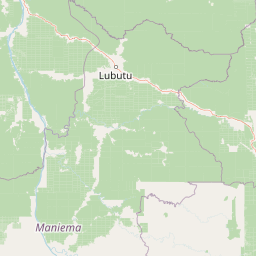
Map view of Maiko National Park

Use this park location map to pinpoint Maiko National Park in Democratic Republic of the Congo, understand its exact geographic position, and read its mapped placement within the surrounding landscape more clearly.

Pigeon | © OpenStreetMap contributors

Location context for Maiko National Park

ManiemaNord KivuProvince Orientale
Recorded earthquake history

Examine Recorded Earthquake History Near Maiko National Park

Review a detailed catalogue of past seismic events linked by location to the forested terrain of Maiko National Park. MoriAtlas provides these historical records to support geographic research and understanding of seismic history in this remote eastern region of the Democratic Republic of the Congo.

Maiko National Park Earthquake History

Catalogued events

25 events

Strongest magnitude

Magnitude 5.3

Most recent event

Sep 16, 2024

This history includes earthquakes recorded inside the park or within 50 km of its borders

Park atlas

Discover the geographic spread of protected areas surrounding Maiko, highlighting regional conservation landscapes in central Africa.

National Parks and Protected Areas Near Maiko National Park for Further Exploration

Browse a curated selection of national parks and protected areas located geographically near Maiko National Park, featuring vast lowland rainforests and crucial habitats for central African endemic species. Comparing these adjacent conservation landscapes offers invaluable atlas-style insights into the regional protected-area network and distinct biodiversity patterns.
National parkSouth Kivu Province
80 km away#1 closest

Southeast

Kahuzi-Biéga National Park: Protected Mountain and Rainforest Geography in South Kivu

Mapped terrain from volcanic summits to equatorial forest basins.

Kahuzi-Biéga National Park represents a significant protected area within the South Kivu Province. The geography features two distinct sectors connected by a narrow ecological corridor, encompassing everything from high-altitude subalpine heather zones to dense tropical lowland environments. This dataset provides a detailed look at the park boundaries, volcanic topography, and the regional landscape context that defines this essential habitat.

Area
6,000 km²
Established
1970
IUCN
II
Relief
Mixed relief
Watercolor illustration of rolling hills, mountains, and a river or lake
National parkDemocratic Republic of the Congo
98 km away#2 closest

East

Virunga National Park: Democratic Republic of the Congo's Premier Protected Landscape

Mapped boundaries and diverse Albertine Rift endemic geography.

Virunga National Park represents a pivotal protected area within the Democratic Republic of the Congo, characterized by an exceptional range of geographic features and vital ecosystems. Its protected landscape includes active volcanoes like Nyiragongo with its lava lake, the towering Rwenzori Mountains, and diverse lowland savannas. This atlas-focused entry highlights the park's unique position in the Albertine Rift, crucial for numerous endemic species and offering significant insight into regional geography and protected land context.

Area
7,800 km²
Established
1925
IUCN
II
Relief
Mountain
National parkUganda
About 157 km away#3 closest

East

Rwenzori Mountains National Park: A Study of Glacial Terrain and Afro-alpine Ecosystems

Explore the mountainous geography of Uganda and its protected high-altitude landscapes.

Defined by massive massifs and retreating glaciers, Rwenzori Mountains National Park features a rare vertical landscape that anchors the geography of western Uganda. Trace the boundaries of this protected area to understand its unique role in supporting biodiversity across distinct vegetation zones, from lowland montane forests to snow-capped summits.

Area
996 km²
Established
1991
IUCN
VI
Relief
Mountain
National parkUganda
About 159 km away#4 closest

East

Rwenzori Mountains National Park: Alpine Geography and Protected Equatorial Mountain Landscapes

Mapped terrain, glacial landscapes, and high altitude ecosystems in southwestern Uganda.

Rwenzori Mountains National Park protects a spectacular high altitude environment rising abruptly from the African rift valley. The park contains Africa's third highest summit, Margherita Peak, and features a unique array of glacial environments, waterfalls, and lakes. Its five distinct vegetation zones host significant biodiversity and endemic species within a critical transfrontier conservation complex.

Area
998 km²
Established
1991
IUCN
II
Relief
Mountain
National parkKanungu District
161 km away#5 closest

East

Bwindi Impenetrable National Park: Uganda's National Park Geography and Mapped Terrain

Explore its protected landscape and regional context.

Delve into the protected landscape of Bwindi Impenetrable National Park, a protected area situated within Kanungu District, Uganda. This detail page offers a deep dive into its geographic setting, presenting mapped park boundaries and natural terrain features essential for understanding its role within the regional atlas. Discover the specific environmental context of this national park for robust map-based exploration.

Area
331 km²
Established
1991
IUCN
II
Relief
Mountain
National parkUganda
About 168 km away#6 closest

East

Queen Elizabeth National Park: Mapped Protected Landscape in Uganda's Geography

Explore Uganda's National Park map and terrain.

Queen Elizabeth National Park represents a significant protected landscape within Uganda, offering a rich context for geographic exploration. As a national park, its mapped boundaries define a unique area for understanding the region's natural terrain and landscape character. This destination provides structured data essential for atlas-based discovery, allowing users to analyze its geographic positioning and its role within Uganda's conservation areas.

Area
1,978 km²
Established
1952
IUCN
II
Relief
Mixed relief
National parkDemocratic Republic of the Congo
170 km away#7 closest

Southwest

Lomami National Park: Central African Protected Landscape and Biodiversity Hub

Explore its lowland tropical rainforest and distinct bonobo habitat.

Lomami National Park is a recently established national park in the Democratic Republic of the Congo, covering nearly 9,000 square kilometers of lowland tropical rainforest. Situated in the central Congo Basin, it plays a crucial role in protecting unique biodiversity, including genetically distinct bonobo populations separated by the Lomami River. The park also supports populations of okapi and the Congo peafowl, making it a vital area for conservation and geographic discovery within Central Africa.

Area
8,879 km²
Established
2016
IUCN
II
Relief
Mixed relief
National parkUganda
About 186 km away#8 closest

Northeast

Semuliki National Park: Protected Lowland Rainforest Geography and Atlas Data

A mapped tropical valley wilderness in western Uganda

Semuliki National Park stands as a significant protected lowland rainforest in Uganda, characterized by a flat, humid valley floor and dense forest corridors along the Semuliki River. This area serves as a rare example of Central African ecological communities preserved within an East African landscape, offering extensive data on its unique vegetation patterns and riparian zones.

Common questions about visiting, size, designation, and location context for Maiko National Park

Maiko National Park FAQs for park facts, access, geography, and protected area context

Find quick answers about Maiko National Park, including protected-area facts, park geography, trail and visitor context, and how the park fits into its surrounding country and regional landscape.
MoriAtlas Explorer

Continue Your Protected Areas Search Across the Global Atlas

Deepen your exploration by continuing the structured search for national parks and protected areas worldwide. Utilize the comprehensive filtering capabilities to compare different conservation landscapes and refine your understanding of global park geography. Discover more about the distribution and characteristics of protected natural areas.

Global natural geography
