

Mori Atlas logo
Marine protected areaBallena National Marine Park

Discover the unique mapped marine boundaries and coastal landscapes of this protected area.

Ballena National Marine Park: Protected Marine Area Atlas and Geography of Costa Rica

(Parque Nacional Marino Ballena)

Ballena National Marine Park, a vital marine protected area in Costa Rica, offers a unique window into the country's Pacific coastal geography. This page serves as a detailed entry point for understanding the park's specific geographic scope, its mapped marine boundaries, and its role as a protected landscape. Explore the regional context and atlas-driven insights that define Ballena National Marine Park, highlighting its significance within Costa Rica's commitment to conservation and natural exploration.

Marine Protected AreaWhale WatchingCoral ReefsPacific CoastSea TurtlesCosta Rica

Ballena National Marine Park

Marine protected area

Park overview

Structured park overview, official facts, and landscape profile for Ballena National Marine Park

Ballena National Marine Park park facts, protected area profile, and essential visitor context

Review the core facts for Ballena National Marine Park, including designation, size, terrain, visitor scale, habitats, and operating context in one park-focused overview.

About Ballena National Marine Park

Ballena National Marine Park occupies a significant stretch of Costa Rica's Pacific coastline and represents one of the country's most important marine protected areas. The park was created in 1990 specifically to safeguard the coastal and marine ecosystems of this region, making it the first marine national park established in Costa Rica. The protected area extends from the shoreline outward into the Pacific Ocean, encompassing coral reef formations, rocky reef substrate, open water, and the coastal beaches that fringe the mainland. The park's location along the Pacific coast places it within a region of exceptional biodiversity, where tropical marine ecosystems meet productive upwelling zones that support abundant marine life. The management of the park focuses on balancing conservation objectives with sustainable tourism, allowing visitors to experience the marine environment while minimizing impacts on wildlife and habitats.

Quick facts and research context for Ballena National Marine Park

Ballena National Marine Park is situated on Costa Rica's southern Pacific coast in Puntarenas province, near the town of Dominical. Established in 1990, it was the first marine national park in Costa Rica and covers both terrestrial coastal areas and adjacent marine waters. The park is most famous for the seasonal presence of humpback whales that visit the area during their migration, typically appearing from December through April. The marine environment features coral reefs, rocky substrate, and productive fishing grounds that support dolphins, sea turtles, and numerous fish species. The park's coastline includes several small islands and beaches that serve as nesting sites for marine turtles.

Protection and recognition

Documented environmental management scope and official marine conservation status

Ballena National Marine Park Protection Status and Conservation Designation

Marine conservation frameworks define the structured management scope and official boundaries of Ballena National Marine Park. Scholars and geographers can analyze verified data on the park's mixed protection status alongside official geographic designations.

Protection details

Protection scope
Mixed
Transboundary protection
No
Park context

Deeper park guide and search-rich context for Ballena National Marine Park

Ballena National Marine Park history, landscape, wildlife, and travel context

Explore Ballena National Marine Park through its history, landscape character, ecosystems, wildlife, conservation priorities, cultural context, and seasonal travel timing in a structured park guide built for atlas discovery and search intent.

Why Ballena National Marine Park stands out

Ballena National Marine Park is best known for its seasonal humpback whale populations that congregate in the protected marine waters to breed and give birth. The park offers one of Costa Rica's most reliable whale-watching opportunities, with guided boat tours providing close encounters with these massive marine mammals. Above the water, the park protects nesting beaches used by olive ridley and hawksbill sea turtles. Beneath the surface, the marine environment features珊瑚礁 and productive reef ecosystems that support diverse fish communities, rays, and other marine life. The park's dramatic rocky islands and sweeping Pacific beaches create a visually striking coastal landscape.

Ballena National Marine Park history and protected-area timeline

Ballena National Marine Park was established in 1990 as Costa Rica's inaugural marine national park, representing a significant milestone in the country's approach to marine conservation. The creation of the park reflected growing recognition of the ecological importance of Costa Rica's Pacific coastal waters and the need to protect critical habitats from development pressures and overfishing. Prior to formal protection, the area had been subject to various human activities including fishing and coastal development. The establishment of the park provided legal framework for restricting destructive practices and managing the area as a coordinated conservation unit. Over the years, the park has become a cornerstone of Costa Rica's marine protected area network and serves as a model for other marine conservation initiatives in Central America.

Ballena National Marine Park landscape and geographic character

The landscape of Ballena National Marine Park combines terrestrial coastal features with the underwater terrain of the Pacific Ocean. Along the shore, the park features sandy beaches interrupted by rocky headlands and points. Several small rocky islands dot the coastal waters, creating distinctive landscape features and important wildlife habitats. The underwater landscape includes coral reef formations that develop on the rocky substrate, as well as sandy bottoms and deeper waters further offshore. The coast is characterized by the dramatic backdrop of the coastal mountain range visible from the shore. The interface between the land and sea creates a dynamic environment where waves shape the coastline and tides expose intertidal zones.

Ballena National Marine Park ecosystems, habitats, and plant life

The marine environment of Ballena National Marine Park supports diverse ecosystems including coral reefs, rocky reef communities, and open water habitats. The coral formations found in the park's waters represent some of the more significant coral reef development along Costa Rica's Pacific coast, providing structure and habitat for numerous marine species. The productive marine waters support dense concentrations of fish, invertebrates, and other organisms. The coastal zone includes mangrove areas that provide important nursery habitat for juvenile fish and crustaceans. The combination of warm tropical waters and nutrient-rich upwelling creates favorable conditions for marine life productivity, supporting everything from small reef fish to large marine mammals.

Ballena National Marine Park wildlife and species highlights

The wildlife of Ballena National Marine Park is defined by its marine species, with the park serving as a critical seasonal habitat for humpback whales that migrate from both northern and southern populations. These whales typically arrive in the warm Pacific waters of the park area during the winter months to breed and give birth, with peak activity typically occurring between December and April. The waters also host dolphin species including spotted dolphins and occasionally killer whales. Sea turtles, particularly olive ridley and hawksbill turtles, use the park's beaches for nesting and may be observed swimming in the nearshore waters. The reef environments support diverse fish communities including groupers, snappers, angelfish, and many others, while rays including sting rays and manta rays are also present.

Ballena National Marine Park conservation status and protection priorities

Ballena National Marine Park represents a fundamental component of Costa Rica's marine conservation network and contributes to the country's broader biodiversity protection goals. The park's protected status helps safeguard critical habitats for threatened and endangered marine species including humpback whales and sea turtles. Management efforts focus on regulating boat traffic in whale congregation areas, controlling fishing activities within park boundaries, and monitoring the health of coral reef and other marine ecosystems. The park demonstrates Costa Rica's commitment to marine protection and provides measurable benefits in terms of species conservation and ecosystem preservation.

Ballena National Marine Park cultural meaning and human context

The name Ballena, meaning whale in Spanish, reflects the historical significance of the area as a seasonal destination for whales and the cultural connection between local communities and marine life. The park is located in a region where fishing and coastal living have traditionally been important livelihoods. The establishment of the marine park created new frameworks for how local communities interact with the marine environment, emphasizing conservation alongside sustainable use. The area has also become an educational resource, helping visitors and local residents understand the ecological importance of marine ecosystems and the species that depend on protected coastal waters.

Top sights and standout views in Ballena National Marine Park

The signature experience at Ballena National Marine Park is the opportunity to observe humpback whales in their tropical breeding grounds, with knowledgeable guides providing safe and informative encounters with these magnificent animals. The park offers excellent snorkeling and diving opportunities to explore coral reef ecosystems teeming with tropical fish and other marine life. The rocky islands serve as roosting sites for seabirds and brown boobies. The combination of accessible beaches, wildlife viewing opportunities, and underwater exploration makes the park a destination that rewards visitors interested in both terrestrial and marine natural history.

Best time to visit Ballena National Marine Park

The optimal time to visit Ballena National Marine Park for whale watching is during the dry season from December through April, when humpback whales are most reliably present in the park's waters. This period offers the best chances of encountering whales and also typically features calmer sea conditions favorable for boat excursions and underwater activities. The green season from May through November brings increased rainfall but also different wildlife opportunities and fewer crowds. Water visibility for snorkeling and diving is generally better during the dry season, though conditions can vary.
Monthly climate preview

Long-term representative monthly averages for temperature and precipitation patterns

Ballena National Marine Park Climate Normals and Annual Temperature Rhythm

Representative coordinates record mean annual temperatures between twenty-four and twenty-seven degrees alongside distinct monthly precipitation variations from NASA data. Examining the complete twelve-month climate profile reveals comprehensive statistical context for regional conservation terrain.
Annual mean26 °C
25 °C27 °C
Jan26°
Feb27°
Mar27°
Apr27°
May26°
Jun26°
Jul25°
Aug25°
Sep25°
Oct25°
Nov25°
Dec25°
Warmest month
March

27.2 °C

Coolest month
October

24.7 °C

Wettest month
October

9.3 mm/day

Driest month
February

1.5 mm/day

Park location guide

Geography guide, regional context, and park location map for Ballena National Marine Park

Ballena National Marine Park park geography, regions, and map view in Costa Rica

Understand where Ballena National Marine Park sits in Costa Rica through a broader geographic reading of the surrounding landscape, nearby location context, and its mapped position within the national park landscape.

How Ballena National Marine Park fits into Costa Rica

Costa Rica is a Central American country with coastlines on both the Caribbean Sea and Pacific Ocean. It gained independence from Spain in 1821 and operates as a unitary presidential republic with no standing military. The economy has diversified from agriculture into finance, pharmaceuticals, and ecotourism.

Wider geography shaping Ballena National Marine Park in Costa Rica

Costa Rica is located in Central America, bordered by Nicaragua to the north, the Caribbean Sea to the northeast, Panama to the southeast, and the Pacific Ocean to the southwest. It shares a maritime boundary with Ecuador. The terrain includes coastal plains, mountain ranges, and volcanic landscapes.

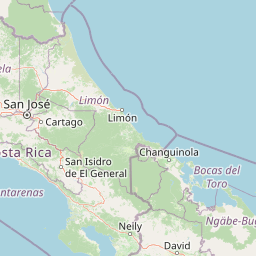
Map view of Ballena National Marine Park

Use this park location map to pinpoint Ballena National Marine Park in Costa Rica, understand its exact geographic position, and read its mapped placement within the surrounding landscape more clearly.

Pigeon | © OpenStreetMap contributors
Park atlas

Trace the regional spread of protected coastal landscapes and marine reserves in Costa Rica's Pacific region.

Explore Related National Parks and Protected Areas Near Ballena National Marine Park

Browse other national parks and protected areas geographically adjacent or ecologically similar to Ballena National Marine Park, spanning Costa Rica's biodiverse Pacific coastline. Compare diverse conservation landscapes, trace the regional network of marine and terrestrial reserves, and expand your atlas view of Central American protected areas.
National parkCartago Province
About 30 km away#1 closest

Northeast

Chirripó National Park: A Protected Landscape within Cartago Province's Geography

Explore its mapped boundaries and natural terrain.

This page provides detailed geographic context for Chirripó National Park, a designated national park located in the Cartago Province of Costa Rica. It focuses on the park's protected landscape identity, its position within the regional geography, and its distinct mapped boundaries. Understanding Chirripó National Park through its geographic and atlas-centric attributes offers a foundational insight into its natural significance.

Area
508.49 km²
Established
1975
IUCN
II
Climate
Alpine
National parkPuntarenas Province
About 33 km away#2 closest

Northwest

Manuel Antonio National Park: Protected Landscape and Geographic Detail

Mapped boundaries and regional atlas context.

Delve into the protected landscape of Manuel Antonio National Park, a notable national park located in Puntarenas Province. This detail entry provides essential geographic context, focusing on mapped park boundaries and regional terrain. Understand its protected-area identity and its contribution to the natural atlas through detailed exploration tools designed for geographic discovery.

Area
275.87 km²
Established
1972
IUCN
II
Visitors
438.8K annual
National parkCosta Rica
About 42 km away#3 closest

North

Los Quetzales National Park: Costa Rica National Park Landscape and Mapped Geography

Explore protected area boundaries and regional terrain context.

Los Quetzales National Park, a designated national park within Costa Rica, offers a focused entry point for exploring protected landscapes. This page provides detailed insight into the park's geographic setting, emphasizing its mapped boundaries and its role within the national atlas. Users can discover the specific landscape characteristics and regional terrain that define Los Quetzales National Park, enriching their understanding of Costa Rican protected areas.

Area
50 km²
Established
2006
IUCN
II
Relief
Mountain
National parkCosta Rica
About 46 km away#4 closest

North

Tapantí National Park: Costa Rica National Park Atlas and Mapped Landscape Exploration

Explore protected boundaries and natural terrain within its geographic setting.

Tapantí National Park is a designated national park in Costa Rica, offering specific insights into the country's protected natural landscapes. This page provides an atlas-style view of its geographic placement, the extent of its protected area, and the character of its natural terrain. Users can investigate the park's mapped context and understand its significance within the broader geography of Costa Rica, facilitating focused exploration of protected lands and regional landscape features.

Area
583.2 km²
Established
1982
IUCN
II
Relief
Mountain
National parkCosta Rica
About 58 km away#5 closest

South

Corcovado National Park: Geographic Boundaries and Rainforest Ecosystems in Costa Rica

Mapping primary forest corridors and coastal protected landscapes.

Corcovado National Park covers much of the Osa Peninsula, protecting the largest primary rainforest stand on the American Pacific coast. The park's rugged terrain includes inland mountainous ridges, extensive river networks, and vital coastal lagoons. This protected area functions as a biological corridor, sustaining diverse habitats that range from lowland tropical forests to elevated montane ecosystems.

Area
424 km²
Established
1975
IUCN
II
Relief
Mixed relief
National parkPuntarenas Province
About 66 km away#6 closest

Southeast

Piedras Blancas National Park: Costa Rica National Park Protected Landscape

Explore Puntarenas Province's mapped protected areas and terrain.

Piedras Blancas National Park is a key protected area within Puntarenas Province, Costa Rica, identified for its national park status. This entry serves as a geographic anchor, detailing the park's mapped landscape and its contribution to the regional protected areas atlas. Understand its specific geographic setting and the importance of its protected boundaries for natural landscape exploration and research, contributing vital context to Costa Rica's conservation geography.

Area
140.19 km²
Established
1991
IUCN
II
Relief
Mountain
National parkCartago Province
About 89 km away#7 closest

North

Irazú Volcano National Park: National Park Protected Area Atlas

Mapped Boundaries and Volcanic Terrain

Irazú Volcano National Park stands as a distinct protected area within the landscape of Cartago Province, Costa Rica. This page provides an atlas-centric view, detailing the park's mapped boundaries and its identity as a national park. Explore the volcanic geography and regional context, understanding its contribution to the protected lands of Central America.

Area
20 km²
Established
1955
IUCN
II
Relief
Mountain
National parkSan José Province
About 89 km away#8 closest

Northwest

La Cangreja National Park: Costa Rican National Park with Distinct Protected Landscape Identity

Explore its mapped boundaries and regional geographic context in San José Province.

La Cangreja National Park serves as a key protected area within the geography of San José Province, Costa Rica. This page facilitates a deeper understanding of its specific landscape character and mapped terrain, crucial for users interested in the structured discovery of national parks and their geographic significance. Examine the park's identity as a protected national park and its placement within the broader atlas of natural landscapes.

Area
19 km²
Established
1987
IUCN
II
Relief
Mountain

Common questions about visiting, size, designation, and location context for Ballena National Marine Park

Ballena National Marine Park FAQs for park facts, access, geography, and protected area context

Find quick answers about Ballena National Marine Park, including protected-area facts, park geography, trail and visitor context, and how the park fits into its surrounding country and regional landscape.
MoriAtlas Explorer

Continue Your Protected Areas Search Across the Global Atlas

Deepen your exploration by continuing the structured search for national parks and protected areas worldwide. Utilize the comprehensive filtering capabilities to compare different conservation landscapes and refine your understanding of global park geography. Discover more about the distribution and characteristics of protected natural areas.

Global natural geography