Mori Atlas logo
Wildlife reserveBird Islands Conservation Park

A vital wildlife reserve featuring intertidal mangroves, sandy shorelines, and coastal shrublands.

Bird Islands Conservation Park: Mapping Coastal Protected Landscapes in South Australia

Bird Islands Conservation Park occupies a unique position along the eastern shores of Spencer Gulf on the Yorke Peninsula. This protected area connects essential intertidal mudflats with mainland coastal terrain, including grey mangrove woodlands, samphire flats, and chenopod shrublands. By preserving these diverse coastal environments, the reserve supports important feeding and roosting grounds for international migratory shorebirds.

coastal reserveislandsmangrovessaltmarshsandy beachescoastal dunes

Bird Islands Conservation Park

Wildlife reserve

Park overview

Structured park overview, official facts, and landscape profile for Bird Islands Conservation Park

Bird Islands Conservation Park park facts, protected area profile, and essential visitor context

Review the core facts for Bird Islands Conservation Park, including designation, size, terrain, visitor scale, habitats, and operating context in one park-focused overview.

About Bird Islands Conservation Park

Bird Islands Conservation Park sits at a meeting point of mangrove forest, samphire saltmarsh, coastal dune shrubland, and open Gulf waters. Although small, it bundles together several of the coastal habitat types that define the eastern Spencer Gulf shoreline, allowing visitors and researchers to experience a sequence of distinct ecological zones within a single protected area.

The core of the park is a pair of low-lying islands fringed by grey mangrove woodlands and chenopod shrublands, with slightly higher sandy ground supporting introduced grasslands and native coast daisy-bush shrubland. The mainland section at Warburto Point extends the protected landscape onto the shore itself, with sandy beaches backed by low dunes and Acacia shrublands. Together these features provide a range of nesting, roosting, and feeding habitats for resident and migratory birdlife.

Beyond its ecological role, the park illustrates how South Australia has progressively expanded small coastal reserves to incorporate intertidal and mainland buffer zones. Today it functions both as a refuge for migratory shorebirds along the East Asian-Australasian Flyway and as a locally valued landscape for low-impact recreation, education, and appreciation of Gulf coast ecosystems.

Quick facts and research context for Bird Islands Conservation Park

Bird Islands Conservation Park is a small protected coastal area in eastern Spencer Gulf, South Australia, centered on Warburto Point southeast of Wallaroo on the Yorke Peninsula. The reserve covers two islands together with an adjacent mainland section and was established in the late 1960s, with later additions in 1991 and 1999 bringing intertidal zones and mangrove-supporting mainland land into the protected boundary. The park is managed under the South Australian Department for Environment and Water and is classified as an IUCN Category VI protected area, recognizing its combined conservation and sustainable-use character.

Protection and recognition

Documented protection scope and official designation records for Bird Islands Conservation Park

Bird Islands Conservation Park Protection Status and International Recognition

Bird Islands Conservation Park maintains a documented mixed protection scope alongside official designation records within the protected area database. Verified governance metrics and international recognition frameworks provide structured context for the conservation landscape.

Protection details

Protection scope
Mixed
Transboundary protection
No
Park context

Deeper park guide and search-rich context for Bird Islands Conservation Park

Bird Islands Conservation Park history, landscape, wildlife, and travel context

Explore Bird Islands Conservation Park through its history, landscape character, ecosystems, wildlife, conservation priorities, cultural context, and seasonal travel timing in a structured park guide built for atlas discovery and search intent.

Why Bird Islands Conservation Park stands out

The park is best known for its importance to migratory shorebirds, including species listed under the Japan-Australia and China-Australia Migratory Bird Agreements such as sharp-tailed sandpiper, red knot, red-necked stint, greater sand plover, grey-tailed tattler, Caspian tern, and Terek sandpiper. It is also recognized for its compact but ecologically varied coastal vegetation, including grey mangrove woodlands, chenopod shrublands, coast daisy-bush thickets, and samphire flats set against sandy beaches and small dunes.

Bird Islands Conservation Park history and protected-area timeline

Bird Islands Conservation Park was formally established on 23 May 1968, originally centered on the two small islands in eastern Spencer Gulf. In 1991, the park's boundaries were expanded to include the surrounding intertidal zones around both islands, recognizing the importance of shallow marine and tidal habitats to the values the reserve was intended to protect.

In 1999, a further expansion added a larger mainland parcel at Warburto Point. This addition was specifically aimed at protecting mangrove, samphire, and coastal fringe vegetation communities that were otherwise vulnerable to shoreline development and recreation pressure. The growing reserve increasingly reflected an integrated approach to coastal conservation across land-and-sea boundaries.

The park is governed by the South Australian Department for Environment and Water, continuing a long tradition in the state of managing small but ecologically significant coastal reserves within a broader network of marine and terrestrial protection.

Bird Islands Conservation Park landscape and geographic character

The landscape of Bird Islands Conservation Park is shaped by its position within the sheltered eastern reaches of Spencer Gulf, where tidal waters meet a low, sandy coastline. The two islands are essentially flat, rising only slightly above sea level, and are surrounded by extensive intertidal mudflats and shallow water.

On the islands, the terrain is made up of sandy, slightly higher ground interspersed with low-lying mangrove-influenced flats. The mainland section at Warburto Point features narrow sandy beaches backed by low dunes, with patches of coastal shrubland climbing the landward side. Overall, the topography is subdued and dominated by the interplay between sea, sand, and intertidal vegetation rather than by dramatic relief.

Bird Islands Conservation Park ecosystems, habitats, and plant life

Ecologically, the park is defined by its coastal and intertidal vegetation communities. Grey mangrove woodlands fringe the islands, giving way inland on higher sandy ground to chenopod shrublands, tall open shrubland of coast daisy-bush, and grasslands of introduced pasture species. The mainland extension replicates this pattern with additional dune-supporting shrublands, samphire flats, and patches of Acacia shrubland.

These varied plant communities create a mosaic of habitats across a very small area. Mangroves and samphire flats dominate the wettest margins, while higher and drier zones support woody shrub and grassland vegetation. The recorded native flora includes nine documented species, reflecting how limited but characteristic the local plant diversity is when compared to larger reserves.

Bird Islands Conservation Park wildlife and species highlights

Birdlife is the heart of Bird Islands Conservation Park's ecological identity. The reserve is a regular destination for migratory shorebirds covered under the Japan-Australia and China-Australia Migratory Bird Agreements, with species including sharp-tailed sandpiper, red knot, red-necked stint, greater sand plover, grey-tailed tattler, Caspian tern, and Terek sandpiper documented as regular visitors.

Additional birds of conservation significance recorded in the park include Cape Barren goose, lesser sand plover, pied oystercatcher, rock parrot, eastern osprey, and fairy tern. Together, resident and migratory species use the islands, mangroves, intertidal flats, and dune-backed beach as feeding, roosting, and resting habitat along an internationally significant flyway.

Bird Islands Conservation Park conservation status and protection priorities

Bird Islands Conservation Park is classified as an IUCN Category VI protected area, recognizing a balance between conservation objectives and sustainable use. Its formal protection covers mangrove woodland, samphire, coastal fringe vegetation, and the surrounding intertidal zones of the islands, creating a reserve that safeguards habitat across the marine-terrestrial interface.

Its conservation significance is heightened by Australia's commitments to international migratory bird treaties, which give the park an important role in protecting shorebird populations that travel vast distances between the northern hemisphere and southern Australia. At the same time, the reserve faces ongoing management challenges from recreational 4WD use, increasing local population pressure from the Copper Coast District Council area, and the broader need to monitor beach driving impacts on coastal vegetation.

Top sights and standout views in Bird Islands Conservation Park

Bird Islands Conservation Park packs a surprising diversity of Gulf coast habitats into a very small footprint: mangrove-fringed islands, samphire flats, chenopod shrublands, dune-backed beaches, and Acacia shrubland. Its standout feature is the regular presence of internationally recognized migratory shorebirds, supported by safe roosting and feeding habitat along eastern Spencer Gulf.

The park's gradual expansion from a small island reserve in 1968 to an integrated coastal and intertidal protected area by 1999 reflects a broader South Australian management philosophy of linking marine and terrestrial conservation in coastal landscapes.

Best time to visit Bird Islands Conservation Park

Because the park is significant for migratory shorebirds, timing can influence what visitors see, with migratory species using the reserve during their seasonal movements along the East Asian-Australasian Flyway. Cooler months along the Spencer Gulf coast typically bring more active bird presence and milder conditions for walking and beach activity, while the islands themselves can be visited at low tide by wading or approached by boat at higher tidal levels. As always, low-impact behavior is essential to minimize disturbance to feeding and roosting birds.
Monthly climate preview

Long term temperature and precipitation records across twelve months of observation

Bird Islands Conservation Park Climate Normals and Annual Temperature Patterns

Representative coordinate measurements reveal marked shifts in average monthly temperatures and precipitation rates throughout the annual cycle at Bird Islands Conservation Park. Comprehensive historical climatology data provides deeper analytical context for evaluating long term environmental conditions across the protected landscape.
Annual mean17 °C
12 °C23 °C
Jan23°
Feb23°
Mar21°
Apr18°
May15°
Jun13°
Jul12°
Aug12°
Sep14°
Oct16°
Nov19°
Dec21°
Warmest month
February

23.1 °C

Coolest month
July

11.9 °C

Wettest month
June

1.5 mm/day

Driest month
January

0.5 mm/day

Park location guide

Geography guide, regional context, and park location map for Bird Islands Conservation Park

Bird Islands Conservation Park park geography, regions, and map view in Australia

Understand where Bird Islands Conservation Park sits in Australia through a broader geographic reading of the surrounding landscape, nearby location context, and its mapped position within the national park landscape.

How Bird Islands Conservation Park fits into Australia

Australia is a constitutional monarchy and federal parliamentary democracy comprising six states and ten territories. With a population of nearly 28 million, it is one of the world's most urbanised countries, with most people concentrated on the eastern seaboard. The country has a high Human Development Index and is known for its cultural diversity, ancient Aboriginal heritage, and unique wildlife.

Wider geography shaping Bird Islands Conservation Park in Australia

Australia occupies the entire Australian continent, the island of Tasmania, and numerous smaller islands. It is the world's flattest and driest inhabited continent, featuring vast deserts in the interior (the Outback), tropical rainforests along the eastern coast, and a coastline bordering the Indian and Pacific Oceans.

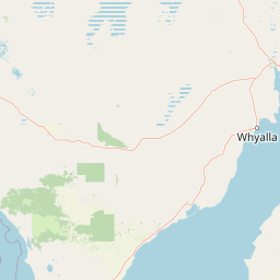
Map view of Bird Islands Conservation Park

Use this park location map to pinpoint Bird Islands Conservation Park in Australia, understand its exact geographic position, and read its mapped placement within the surrounding landscape more clearly.

Pigeon | © OpenStreetMap contributors

Location context for Bird Islands Conservation Park

South Australia
Park atlas

Compare surrounding protected areas and regional coastal landscapes across South Australia.

Parks Near Bird Islands Conservation Park and Related Coastal Reserves

Browse other protected areas near Bird Islands Conservation Park to examine regional coastal reserves and mangrove habitats. Expanding the geographic comparison reveals connected marine and terrestrial conservation networks along Spencer Gulf.
Nature reserveSouth Australia
About 51 km away#1 closest

South

Goose Island Conservation Park: Marine Nature Reserve Geography and Protected Island Boundaries

Spencer Gulf offshore refuge and seabird breeding habitat

Goose Island Conservation Park consists of a scattered ring of islands and rocky outcrops in the Spencer Gulf. This nature reserve provides a secluded, wind-swept environment that serves as a vital sanctuary for breeding black-faced cormorant populations and Australian sea lions. The area is defined by its marine-weathered terrain and offshore isolation, acting as a protected link in the broader coastal geography of South Australia.

Area
0.35 km²
Established
1972
IUCN
III
Visitors
300 annual
A wide watercolor illustration showing a coastal scene with green trees, a pinkish shoreline, and pale blue water against a white background.
State or regional parkSouth Australia
About 53 km away#2 closest

East

Clinton Conservation Park: A Protected Coastal Wetland Reserve in South Australia

Mapping mangrove forests, tidal flats, and estuarine habitats.

Clinton Conservation Park protects a significant coastal corridor at the head of Gulf St Vincent, where mangroves, samphire flats, and low backing dunes create a rare, continuous sequence of undisturbed wetland environments. This park serves as a key nursery for regional aquatic species and a habitat node for migratory bird populations in South Australia.

Area
19.15 km²
Established
1970
IUCN
III
Relief
Lowland
A horizontal watercolor illustration of a coastal landscape with pale pink water, green marshy shorelines, and distant soft blue hills against a white background.
Nature reserveSouth Australia
58 km away#3 closest

Northwest

Franklin Harbor Conservation Park: Coastal Nature Reserve and Eyre Peninsula Protected Geography

Coastal conservation park and island habitat system in South Australia

This nature reserve protects rare mangrove and samphire flat associations along the eastern coast of the Eyre Peninsula. The geography encompasses a sheltered peninsula and four islands within the harbor, forming an essential maritime habitat for seabirds and reptiles in the South Australian coastal landscape.

Area
13.56 km²
Established
1976
IUCN
Ia
Relief
Lowland
Natural monumentSouth Australia
About 74 km away#4 closest

Northeast

Clements Gap Conservation Park: A South Australian Natural Monument and Cultural Landscape

Mapping bushland corridors and historic heritage in the Mid North region.

Clements Gap Conservation Park occupies a 7.9 square kilometre footprint, offering a glimpse into the natural terrain of the Mid North region. The area functions as a protected monument that preserves native bushland alongside the built traces of a historic township, showcasing the layered human and environmental geography characteristic of the Spencer Gulf hinterland.

Area
7.9 km²
Established
1963
IUCN
III
Relief
Upland
Protected landscapeSouth Australia
About 93 km away#5 closest

Northwest

Ironstone Hill Conservation Park: Geography and Protected Land Map Overview

An essential protected landscape in the Eyre Peninsula of South Australia.

Ironstone Hill Conservation Park protects fragile sandy dune systems and dense mallee vegetation within an arid zone. This conservation area acts as a vital link in the regional natural network, neighboring both private reserves and active mineral-bearing ranges. The park provides an essential study of semi-arid terrain and rare species habitat in the heart of the Eyre Peninsula.

Area
196.5 km²
Established
2010
IUCN
VI
Relief
Upland
National parkAustralia
About 101 km away#6 closest

Southeast

Adelaide International Bird Sanctuary National Park, Winaityinaityi Pangkara National Park: Protected Landscape and Geographic Context

Explore the mapped natural terrain of this Australian protected area.

This national park page offers detailed insights into Adelaide International Bird Sanctuary National Park, Winaityinaityi Pangkara, focusing on its protected status and geographic attributes. Understand the park's placement within Australia, its mapped boundaries, and the natural landscape features that define it. It serves as a vital entry point for atlas-driven discovery of protected areas, emphasizing the geographical context of this significant national park.

Access
Access unknown
Season
Seasonal
Wildlife reserveSouth Australia
About 115 km away#7 closest

Northwest

Heggaton Conservation Park: A Protected Wildlife Reserve on the Eyre Peninsula

Mapping the semi-arid mallee woodlands of South Australia

Heggaton Conservation Park is a key wildlife reserve in South Australia that safeguards extensive mallee forest and Melaleuca shrubland. This protected area provides an essential, relatively undisturbed habitat for Malleefowl and various rare plant species within the broader Eyre Peninsula landscape.

Area
64.76 km²
Established
1993
IUCN
VI
Relief
Lowland
Protected areaSouth Australia
About 117 km away#8 closest

South

Carribie Conservation Park: Mapped Geography and Protected Area Overview in South Australia

Ecological terrain and native vegetation remnants on the Yorke Peninsula

Carribie Conservation Park is a 19-hectare protected area situated on the southern Yorke Peninsula of South Australia. The terrain consists of an undulating sandy plain characterized by two contrasting vegetation zones: a northern mallee scrub and a southern sheoak and tea-tree woodland. As a formal conservation site, it provides a vital window into the original botanical character of the region.

Area
0.19 km²
Established
1968
IUCN
III
Relief
Lowland

Common questions about visiting, size, designation, and location context for Bird Islands Conservation Park

Bird Islands Conservation Park FAQs for park facts, access, geography, and protected area context

Find quick answers about Bird Islands Conservation Park, including protected-area facts, park geography, trail and visitor context, and how the park fits into its surrounding country and regional landscape.
MoriAtlas Explorer

Continue Your Protected Areas Search Across the Global Atlas

Deepen your exploration by continuing the structured search for national parks and protected areas worldwide. Utilize the comprehensive filtering capabilities to compare different conservation landscapes and refine your understanding of global park geography. Discover more about the distribution and characteristics of protected natural areas.

Global natural geography