

Mori Atlas logo
National parkBorena National Park

Discover the mapped boundaries and regional context of this Ethiopian national park.

Borena National Park: Ethiopia's Protected Landscape and National Park Geography

(Borana National Park)

Borena National Park represents a significant protected landscape within Ethiopia, situated in the Horn of Africa. As a designated national park, it offers a crucial point of reference for understanding the country's natural terrain and regional geography. This page provides detailed atlas-style information, focusing on the park's mapped boundaries and its place within the broader Ethiopian landscape, enabling structured discovery of its protected area identity.

national parkEthiopiasavannahendemic speciesbirdwatchingwildlife conservation

Borena National Park

National park

Park overview

Structured park overview, official facts, and landscape profile for Borena National Park

Borena National Park park facts, protected area profile, and essential visitor context

Review the core facts for Borena National Park, including designation, size, terrain, visitor scale, habitats, and operating context in one park-focused overview.

About Borena National Park

Borena National Park represents one of Ethiopia's most significant protected wilderness areas, covering an expansive territory of over 45,000 square kilometers in the country's southern region. The park's territory extends across both the Borena Zone of Oromia Region and the Liben Zone of Somali Region, reflecting the ecological diversity of this transition zone between the Ethiopian Highlands and the surrounding lowlands. The park was established in 1986, initially designated as a controlled hunting zone before being redesignated as a national park due to management concerns. The conservation area is organized into multiple distinct blocks including Yabello, Dida-Hara, Gammedo, Danbala-Dhibayu, and Sarite, each characterized by unique biodiversity profiles, community characteristics, and environmental conditions. The park's southern boundary borders Kenya, creating an important transboundary conservation corridor. Adjacent protected areas including Chelbi Wildlife Reserve, Geraille National Park, Yabelo Wildlife Sanctuary, and Arero National Forest Priority Area form a connected network of habitat protection in this region of Horn of Africa.

Quick facts and research context for Borena National Park

Borena National Park covers approximately 45,366 square kilometers in southern Ethiopia, making it one of the country's largest protected areas. The park was established in 1986 and is managed jointly by the Oromia Forest and Wildlife Enterprise and the Ethiopian Wildlife Conservation Authority. It occupies a strategic location at the southern edge of the Ethiopian Highlands, sharing a border with Kenya and connecting to a network of adjacent wildlife reserves and sanctuaries. The park contains remarkable biodiversity including at least 40 mammal species and over 280 bird species, with notable populations of both plain zebras and the endangered Grevy's zebra.

Park context

Deeper park guide and search-rich context for Borena National Park

Borena National Park history, landscape, wildlife, and travel context

Explore Borena National Park through its history, landscape character, ecosystems, wildlife, conservation priorities, cultural context, and seasonal travel timing in a structured park guide built for atlas discovery and search intent.

Why Borena National Park stands out

Borena National Park is uniquely distinguished by its protection of two zebra species that rarely coexist in the same habitat: the common Grant's zebra and the endangered Grevy's zebra, which is considered threatened globally. The park is also renowned for its population of Ethiopian bushcrows, white-tailed swallows, Ruspoli's turacos, and black-fronted spurfowl, four endemic bird species that are classified as endangered. The landscape features distinctive maar lakes including El Sod, a saline crater lake that serves as an important tourist attraction and local resource for mineral water and salt. The park's vegetation spans the Somali Acacia-Commiphora bushlands and thickets in the lower areas to Ethiopian montane forests in the northern highlands.

Borena National Park history and protected-area timeline

Borena National Park was established in 1986 as a protected area in southern Ethiopia. The territory was originally designated as a controlled hunting zone before being redesignated to national park status due to concerns about management effectiveness. The transformation from a hunting zone to a fully protected national park reflected growing recognition of the area's ecological significance and the need for stronger conservation measures. Today, the park is administered jointly by the Oromia Forest and Wildlife Enterprise of the Oromia Regional Government and the Ethiopian Wildlife Conservation Authority, the national body responsible for protected area management. The establishment of the park aimed to restore wildlife populations and support community-based environmental recovery, with specific goals including repopulating zebra species and protecting vulnerable species populations.

Borena National Park landscape and geographic character

Borena National Park occupies a diverse landscape at the southern edge of the Ethiopian Highlands, where the highland plateau meets the surrounding lowland ecosystems. The terrain varies significantly across the park's extensive area, from mountainous regions in the north near Arero to vast savannah plains and woodland valleys in other sections. The park contains three notable maar lakes, volcanic crater lakes that form distinctive geological features in the landscape. El Sod is particularly notable as a saline crater lake that provides local communities with access to mineral water and various salt varieties. The Sarite block features widespread grassland and dry open savannah, while the Dida-Hara block contains drought-resistant woodlands characterized by Boscia mossambicensis and Acacia tortilis trees. The northern-central portion of the park includes dry Afromontane regions with dry evergreen trees and juniper forest, representing a distinct highland habitat type within the broader protected area.

Borena National Park ecosystems, habitats, and plant life

The park encompasses several distinct ecological zones that support remarkable plant and habitat diversity. Approximately 327 plant species have been documented within the Borena region, distributed among 197 genera and 69 families, with composition breakdown including 40 percent trees and shrubs, 30 percent forbs, 16 percent grasses, 10 percent climbers, 2 percent sedges, and 2 percent succulents. The majority of the park falls within the Somali Acacia-Commiphora bushlands and thickets ecoregion, characterized by dry woodland and savannah vegetation adapted to semi-arid conditions. The Ethiopian montane forests ecoregion extends into the north-central portion of the park, where dry Afromontane forest occurs in the mountainous regions near Arero, featuring dry evergreen trees and juniper. The conservation area is divided into multiple blocks based on biodiversity, community, and environmental characteristics, allowing for differentiated management approaches across the park's varied habitats.

Borena National Park wildlife and species highlights

Borena National Park supports at least 40 mammal species and provides critical habitat for two species of zebras that are found within the grasslands and woodland areas. The park is uniquely significant for protecting both plain zebras, also known as Grant's zebras, and the endangered Grevy's zebra, a species that has suffered significant population declines across its range. Other notable mammals inhabiting the park include lesser kudus, greater kudus, black-backed jackals, Beisa oryxes, gerenuks, warthogs, Soemmerring's gazelles, and Grant's gazelles. The park once supported herds of Swayne's hartebeest, but this species has been extirpated from the region. The bird fauna is equally remarkable, with at least 280 species recorded. Four endemic bird species are particularly significant: Ethiopian bushcrows, white-tailed swallows, Ruspoli's turacos, and black-fronted spurfowl, all considered endangered. Additional notable species include ostriches, short-tailed larks, red-bellied parrots, vulturine guineafowl, and numerous other savannah and woodland bird species.

Borena National Park conservation status and protection priorities

Borena National Park was established with specific conservation objectives focused on restoring wildlife populations and supporting ecological recovery. The park's establishment aimed to repopulate zebra species, particularly the endangered Grevy's zebra, and protect the vulnerable Bush crow population. The conservation strategy incorporates community-based environmental recovery approaches, recognizing the important relationship between local communities and the park's ecosystems. However, the park faces significant ongoing threats including periodic droughts that affect wildlife populations, expansion of invasive species, overgrazing by livestock, and road collisions that cause wildlife mortality. The joint management structure involving both regional and national authorities reflects the complexity of conserving this large landscape, though resource constraints and environmental challenges continue to present difficulties for effective protection.

Borena National Park cultural meaning and human context

Borena National Park occupies territory traditionally associated with pastoral communities in southern Ethiopia. The park's landscape includes areas of cultural significance, such as the El Sod crater lake which provides local communities with access to mineral water and salt resources that have been utilized historically. The park spans administrative boundaries between Oromia Region and Somali Region, reflecting the geographic distribution of indigenous communities in this border area. Conservation in the region operates within the context of balancing wildlife protection with the livelihood needs of local populations who depend on the surrounding lands for pastoral activities.

Top sights and standout views in Borena National Park

The park's defining features include its exceptional zebra diversity, with both Grant's zebras and endangered Grevy's zebras coexisting in the savannah and woodland habitats. The four endangered endemic bird species, particularly the Ethiopian bushcrow found near Yabelo, represent globally significant biodiversity that cannot be found anywhere else. The maar lakes including El Sod offer unique geological attractions and provide resources for local communities. The vast 45,000-square-kilometer expanse makes it one of Ethiopia's largest protected areas, creating important habitat connectivity with adjacent wildlife reserves and sanctuaries. The diversity of landscapes from highland forests to dry savannah supports the remarkable variety of species that call this park home.

Best time to visit Borena National Park

The optimal period for visiting Borena National Park falls during the dry season, typically from October through April, when wildlife viewing conditions are most favorable as animals congreg around remaining water sources and vegetation is less dense. The wet season from June to September brings seasonal rains that transform the landscape with fresh greenery but can make some roads difficult to traverse and wildlife more dispersed. The cooler months from November to February often provide the most comfortable conditions for game viewing and outdoor exploration. Visitors should be aware that the park region experiences periodic droughts, which can affect wildlife availability and landscape conditions.

Monthly climate preview

Long-term monthly temperature and precipitation averages for Borena National Park

Borena National Park Climate Normals, Annual Temperature and Precipitation Rhythm

Borena National Park experiences a measured annual climate cycle defined by historical temperature and precipitation averages recorded at a representative coordinate. Examining the complete twelve-month dataset provides a detailed statistical profile of monthly thermal and moisture variations across the landscape.
Annual mean22 °C
20 °C24 °C
Jan23°
Feb24°
Mar24°
Apr22°
May21°
Jun20°
Jul20°
Aug20°
Sep22°
Oct22°
Nov21°
Dec22°
Warmest month
February

24.2 °C

Coolest month
July

19.6 °C

Wettest month
April

4.2 mm/day

Driest month
February

0.4 mm/day

Park location guide

Geography guide, regional context, and park location map for Borena National Park

Borena National Park park geography, regions, and map view in Ethiopia

Understand where Borena National Park sits in Ethiopia through a broader geographic reading of the surrounding landscape, nearby location context, and its mapped position within the national park landscape.

How Borena National Park fits into Ethiopia

Ethiopia is a landlocked federal parliamentary republic located in the Horn of Africa. With a population of approximately 135 million people, it is the 14th-most populous country in the world and the most populous landlocked country. The country is known for its ancient history, diverse ethnic groups, and the capital Addis Ababa, which lies near the East African Rift.

Wider geography shaping Borena National Park in Ethiopia

Ethiopia is located in the Horn of Africa, bordered by Eritrea to the north, Djibouti to the northeast, Somalia to the east, Kenya to the south, South Sudan to the west, and Sudan to the northwest. The country sits on the African and Somali tectonic plates, with the East African Rift running through it. The terrain includes highlands, valleys, and lowlands.

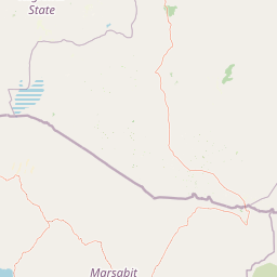
Map view of Borena National Park

Use this park location map to pinpoint Borena National Park in Ethiopia, understand its exact geographic position, and read its mapped placement within the surrounding landscape more clearly.

Pigeon | © OpenStreetMap contributors

Location context for Borena National Park

Oromia
Park atlas

Explore adjacent wildlife reserves and regional conservation landscapes surrounding Borena National Park in the Ethiopian Highlands.

Discover Other National Parks and Protected Areas Near Borena National Park

Continue your exploration from Borena National Park by tracing nearby protected areas and diverse conservation landscapes across southern Ethiopia. Compare regional park geography, from highland forests to vast savannahs, uncovering interconnected habitats and unique biodiversity beyond Borena's extensive boundaries.
National parkOromia Region
Mapped park locations coincide#1 closest

Borana National Park National Park: Geographic Context and Protected Landscape Atlas

Explore the mapped boundaries and regional geography.

Gain a detailed understanding of Borana National Park, identified as a national park within the Oromia Region of Ethiopia. This entry focuses on its geographic context, providing mapped information crucial for understanding its protected landscape identity. Examine how Borana National Park fits into the broader atlas of conservation areas, offering a precise view of its unique terrain and regional significance without operational details.

Area
45,366 km²
Established
1986
IUCN
II
Relief
Mountain
National parkMarsabit County
About 202 km away#2 closest

South

Marsabit National Park: Protected Area Identity and Geographic Setting in Kenya

Explore mapped landscape and regional park geography.

Marsabit National Park represents a critical protected area within the geographic expanse of Marsabit County, Kenya. This entry provides essential context for understanding the park's specific identity as a national park, its delineated boundaries, and its place within the natural landscape. For those interested in atlas-style exploration, this park detail offers foundational geographic information and insights into its protected status, anchoring its role in a broader discovery of Kenya's natural heritage.

Area
1,554 km²
Established
1949
Relief
Mountain
Climate
Subtropical
National parkSouth Ethiopia Regional State
About 238 km away#3 closest

Northwest

Nechisar National Park: Protected Natural Landscape in South Ethiopia Regional State

Explore the mapped geography and protected area context of this Ethiopian park.

Nechisar National Park is designated as a national park, serving as a critical protected natural area within the South Ethiopia Regional State. This MoriAtlas entry provides detailed geographic context, focusing on the park's mapped boundaries and its place within the regional landscape. Users can explore the park's identity as a protected territory, offering a foundation for understanding Ethiopia's natural protected areas through a geographic lens.

Area
1,030 km²
Established
1974
IUCN
II
Relief
Mixed relief
National parkMandera County
About 245 km away#4 closest

East

Malka Mari National Park: Remote Frontier Protected Landscape and Dawa River Ecosystem

Explore the semi-arid bushland and riparian woodland geography.

Malka Mari National Park offers a profound wilderness experience as Kenya's most remote national park, situated along the Dawa River in Mandera County. This protected area features striking contrasts between arid bushland and verdant riparian woodlands, supporting unique plant species and wildlife adapted to the semi-arid environment. Its vast, undeveloped character makes it a significant site for frontier conservation and a unique destination for atlas-style landscape exploration.

Area
1,500 km²
Established
1989
IUCN
II
Climate
Arid
National parkRift Valley Province
About 248 km away#5 closest

West

Sibiloi National Park: National Park with Mapped Geographic Boundaries

Explore the protected landscape of Rift Valley Province.

Sibiloi National Park is a designated national park offering a distinct protected landscape within the broader geographic region of Rift Valley Province, Kenya. This entry focuses on its mapped boundaries and its identity as a key area for conservation, providing a structured view for geographic atlas exploration. Understand the foundational elements of Sibiloi National Park's protected status and its place within regional natural landscapes.

Area
1,570.85 km²
Established
1973
IUCN
II
Relief
Mixed relief
National parkBale Zone
About 284 km away#6 closest

Northeast

Bale Mountains National Park National Park: Explore Protected Landscape and Regional Geography

Mapped boundaries and natural terrain context for this Ethiopian park.

Delve into Bale Mountains National Park, a designated national park in Ethiopia's Bale Zone, focusing on its role as a vital protected landscape. This page offers detailed insights into the park's mapped boundaries and its contribution to the regional geography, providing a foundation for structured atlas exploration of protected areas and natural terrain. Understand the geographic significance and landscape identity of this key conservation entity within the broader context of Ethiopia's natural heritage.

Area
2,220 km²
Established
1970
IUCN
II
Relief
Mountain
National parkKenya
About 289 km away#7 closest

West

Central Island National Park: Kenya National Park Atlas and Protected Landscape

Discover the mapped geography and protected area context.

Central Island National Park is a designated national park in Kenya, offering a distinct protected landscape within the country's expansive Rift Valley. This detailed entry focuses on the park's geographic identity and its significance as a protected area, providing users with clear information on its mapped boundaries and regional landscape context. Dive into the specific geography and natural terrain that distinguish Central Island National Park for comprehensive atlas-style exploration.

IUCN
II
Scope
Mixed
National parkEthiopia
About 294 km away#8 closest

Northwest

Maze National Park: Ethiopia's Essential National Park for Swayne's Hartebeest and Geothermal Wonders

Discover mapped savanna ecosystems and unique montane geography within this protected Ethiopian landscape.

Maze National Park represents a significant protected area within Ethiopia, vital for the conservation of the endangered Swayne's hartebeest. Its diverse terrain includes savanna grasslands and unique geothermal features such as active geysers, all set against a distinctive montane backdrop. This national park offers a deep dive into Ethiopia's natural heritage, providing a clear geographic identity and valuable context for landscape exploration.

Area
210 km²
Established
2005
IUCN
II
Relief
Mixed relief

Common questions about visiting, size, designation, and location context for Borena National Park

Borena National Park FAQs for park facts, access, geography, and protected area context

Find quick answers about Borena National Park, including protected-area facts, park geography, trail and visitor context, and how the park fits into its surrounding country and regional landscape.
MoriAtlas Explorer

Continue Your Protected Areas Search Across the Global Atlas

Deepen your exploration by continuing the structured search for national parks and protected areas worldwide. Utilize the comprehensive filtering capabilities to compare different conservation landscapes and refine your understanding of global park geography. Discover more about the distribution and characteristics of protected natural areas.

Global natural geography