Mori Atlas logo
Nature reserveBurgaue

A historic municipal woodland preserved as a protected floodplain forest and wetland refuge.

Burgaue Nature Reserve: Mapping the Alluvial Forest and Riverine Landscape of Leipzig, Germany

(Naturschutzgebiet Burgaue)

Burgaue represents a core segment of the Elster Luppe floodplain system located in northwestern Leipzig, Germany. This nature reserve protects a mosaic of hardwood alluvial forest, historic river channels, and modern watercourse restorations that define the local lowland terrain. The area serves as a critical ecological corridor within the urban landscape, showcasing centuries of hydrological evolution and active environmental management.

floodplain forestAuwaldhardwood alluvial forestriverine landscapenature reserveurban nature

Burgaue

Nature reserve

Park overview

Structured park overview, official facts, and landscape profile for Burgaue

Burgaue park facts, protected area profile, and essential visitor context

Review the core facts for Burgaue, including designation, size, terrain, visitor scale, habitats, and operating context in one park-focused overview.

About Burgaue

The Burgaue is a forest and floodplain landscape on Leipzig's northwestern perimeter, forming part of the city's broader Auwald (floodplain forest) system. Within the Elster–Luppe floodplain (Elster-Luppe-Aue), which extends across state borders, Burgaue represents the northwestern segment on Leipzig municipal territory. Its borders are defined by adjacent cadastral districts including Lützschena and Stahmeln to the north, Wahren and Möckern to the east, and Leutzsch and Böhlitz-Ehrenberg to the south and west.

The natural boundaries of the Burgaue were historically the Hundewasser stream to the north and the Luppe river to the south. Over time, the southern channels passed through phases of decline, regularization, and partial drying, with portions that once carried water now reduced to drainage ditches or completely lost as flowing watercourses. The current landscape reflects these shifts: a mix of older floodplain morphology, altered channels, and ongoing efforts to restore natural hydrology.

Throughout its history, the Burgaue has also had a close administrative relationship with the city of Leipzig. Originally acquired by the city in 1367 as the Luch woodland, it functioned as a fuel reserve for Leipzig's citizens. Later records refer to it as the Bürgeraue. The area's long inclusion in city land use shaped forest management practices, and today the floodplain reserve stands at the intersection of cultural, historical, and natural heritage for Leipzig's northwestern fringe.

Quick facts and research context for Burgaue

Burgaue lies on the northwestern outskirts of Leipzig, bordering the districts of Lützschena, Stahmeln, Wahren, Möckern, Leutzsch, and Böhlitz-Ehrenberg. It forms the Leipzig portion of the larger Elster–Luppe floodplain complex that crosses the border into Saxony-Anhalt.

The area has held protected status since March 30, 1961, when it was first designated as a nature reserve. It was initially protected across roughly 43 ha and has since expanded to cover approximately 270 ha. A later restoration project (December 1997 to March 1999) reintroduced a meandering watercourse known as the Burgauenbach, reconnecting several historic flood channels and side arms of the former Luppe river system.

Protection and recognition

Documented terrestrial protection scope, establishment year, and conservation recognition records

Burgaue Protection Status and Designation History in the Protected Area Atlas

Burgaue maintains a documented terrestrial protection scope established in 1961 without active transboundary status or imported international recognition sources. Official conservation records outline the structural designation history and governance parameters for the protected area.

Protection details

Protection scope
Terrestrial
Designated year
1961
Transboundary protection
No
Park context

Deeper park guide and search-rich context for Burgaue

Burgaue history, landscape, wildlife, and travel context

Explore Burgaue through its history, landscape character, ecosystems, wildlife, conservation priorities, cultural context, and seasonal travel timing in a structured park guide built for atlas discovery and search intent.

Why Burgaue stands out

Burgaue is known chiefly for its alluvial hardwood forest (Auwald) character. It represents a well preserved example of what a central European lowland floodplain forest can look like, with mature trees, seasonal flooding patterns, and a network of channels and oxbow features. The reserve is also recognized for the multi-year restoration work that revived sections of the historic Luppe floodplain, including the construction of the Burgauenbach. This re-watering effort turned long-dry channels back into functioning wetland habitat and reinforced the area's ecological value within the larger Leipzig floodplain system.
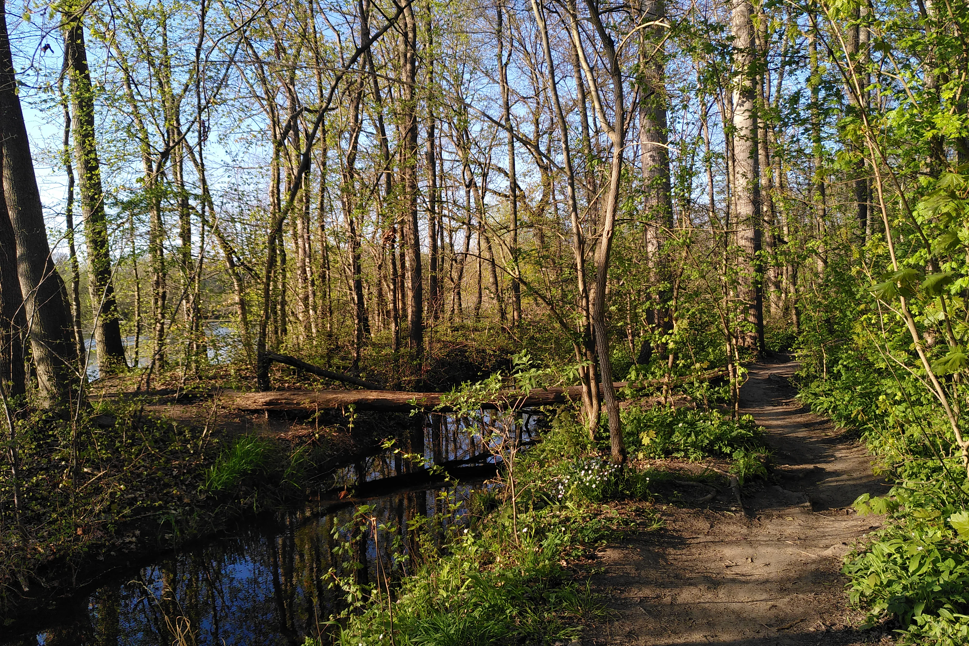
A dirt hiking trail runs alongside a small, slow-moving stream in a dense, green deciduous forest during spring.
A narrow dirt path winding through the lush floodplain forest of the Burgaue nature reserve.

Burgaue history and protected-area timeline

The earliest documented chapter of the Burgaue begins on May 6, 1367, when the city of Leipzig purchased what was then called the Luch, a woodland of about 500 Acker (roughly 277 ha). The motive for the purchase was practical: securing a steady supply of firewood for the city's residents. Following this acquisition, the area appears on old maps under the name Bürgeraue.

In administrative terms, the Burgaue was organized as its own Gutsbezirk (rural district). Until 1900, only the forest warden and his family, four people in total, were recorded as residents. By 1907, the forest was photographed as a recognizable landscape feature of Leipzig's northwest. On April 1, 1925, the Gutsbezirk Burgaue was formally incorporated into the city of Leipzig, ending its separate administrative status.

Protection followed from March 30, 1961, when the area was first placed under nature protection on a footprint of about 43.2 ha. The reserve later grew to its present size of approximately 270 ha. A restoration program between December 1997 and March 1999 reintroduced flowing water to parts of the Burgaue and the neighboring Leutzscher Holz, creating the 5.374 km Burgauenbach and re-using historic flood channels and side arms. The cost of that effort was recorded at 1.5 million Deutsche Mark.

Burgaue landscape and geographic character

The landscape of the Burgaue is shaped by the hydrological legacy of the Elster and Luppe river systems. Historically, its edges were the Hundewasser in the north and the Luppe in the south, with a floodplain carrying seasonal high water between them. The result is a low-relief, riverine terrain dominated by woodland and crisscrossed by channels, ditches, and depressions.

Over the 19th and 20th centuries, natural river dynamics were altered by flood control and drainage. The southern boundary of the Burgaue is therefore partially defined today by a section historically labeled Nahle, parts of it reduced to drainage channels or laid dry entirely. Even so, the area retains a clearly identifiable floodplain morphology, with old channels, back-swamp depressions, and subtle elevation shifts that mark former river courses.

The Burgauenbach, constructed in 1997 to 1999 and running for 5.374 km along the reserve, reintroduced a meandering surface watercourse into this landscape. The watercourse partly follows older, dry channels and partly follows newly prepared beds, and is registered as a Gewässer II. Ordnung (class II watercourse). It directly defines the hydrological character of the Burgaue today and shapes how the landscape is experienced.

Burgaue ecosystems, habitats, and plant life

The Burgaue belongs to central European hardwood floodplain forest (Hartholzauwald). The vegetation reflects long exposure to the hydrology of the Elster and Luppe systems, with communities adapted to periodic flooding, fluctuating groundwater, and the nutrient-rich soils typical of alluvial environments.

The reserve sits inside a larger mosaic that includes the Elster- and Pleiße floodplain forests, the Lehmlache Lauer area, and the Luppeaue. Within this mosaic, Burgaue contributes the northwestern segment, and its habitat value depends substantially on hydrological connectivity, groundwater recharge, and the restoration of lost channels. The re-watering of the Burgauenbach in the late 1990s was explicitly aimed at strengthening this connectivity and re-establishing wet woodland habitat dynamics.

As a Naturschutzgebiet, Burgaue has a legal protection framework aimed at maintaining and developing this alluvial forest system. The nature reserve designation reflects both its role as a habitat for floodplain species and its significance for the overall ecological condition of the urban floodplain landscape around Leipzig.

Burgaue wildlife and species highlights

Direct, specific wildlife inventories for Burgaue are not extensively documented in the available source material, and detailed species accounts are therefore not produced here. The reserve's habitat type, alluvial hardwood floodplain forest with active and restored channels, ditches, and wet depressions, is the kind of environment that typically supports central European floodplain forest fauna, including woodland birds, amphibians in wet channels, and the small mammals associated with mature deciduous forest.

The functioning of this habitat pattern depends on the hydrological restoration work in and around the Burgauenbach. Channels that are reconnected to flow, even on a seasonal basis, provide additional breeding and feeding grounds for amphibians and aquatic invertebrates, while still water in the depressions supports the broader alluvial forest ecosystem.

Burgaue conservation status and protection priorities

Conservation significance for the Burgaue is anchored in its formal status as a Naturschutzgebiet, the strongest category of area protection under German nature conservation law. The reserve was first specified on March 30, 1961, on 43.2 ha, and has since grown to approximately 270 ha, meaning the last six decades have brought an effective expansion of its protected footprint.

The area's conservation value is tightly linked to the condition of the wider Elster–Luppe floodplain. Because the Burgaue occupies only a portion of that landscape, its ecological health depends on the management of the broader river and floodplain system. The 1997 to 1999 renaturation project, which created the Burgauenbach and revived historical flood channels, was a direct conservation intervention aimed at improving this hydrological health at a cost of 1.5 million Deutsche Mark.

Within Leipzig, the Burgaue is one of three recognized nature reserves, alongside the Elster- and Pleiße floodplain forests and the Lehmlache Lauer area, plus the Luppeaue. Together these reserves form the protected backbone of the city's Auwald, a regionally distinctive urban floodplain ecosystem.

Burgaue cultural meaning and human context

The Burgaue has a specifically civic cultural dimension tied to its medieval acquisition by the city of Leipzig. The 1367 purchase of the Luch woodland made the area a municipal forest, with the explicit purpose of supplying fuel wood to Leipzig's citizens. This origin as a commons resource for urban use remained an identifying feature for centuries, even as the woodland's name shifted from Luch to Bürgeraue and eventually Burgaue.

The Burgaue has also remained embedded in the urban identity of Leipzig through its later history. Until 1900, the reserve's only official residents were a forest warden and his family of four, underscoring the wooded, lightly populated character of the area even at moments when surrounding rural communities of Stahmeln, Lützschena, Wahren, Leutzsch, and Böhlitz-Ehrenberg were growing. The 1925 incorporation of the Gutsbezirk Burgaue into Leipzig formalized what had long been the case in practice. A 1907 photographic record of the forest is preserved, showing the area as a recognizable part of Leipzig's northwestern landscape.

Top sights and standout views in Burgaue

The Burgaue stands out as the northwestern main segment, inside Leipzig, of the cross-regional Elster–Luppe floodplain. Its identity rests less on dramatic topographic variation and more on the integrity of its alluvial forest habitat, the layered history of how its channels have been managed and altered over several centuries, and the explicit effort to restore lost hydrology.

A defining highlight is the restoration of the Burgauenbach, a 5.374 km watercourse that uses parts of the historic Luppe flood channels. The trail of administrative and ecological designations (1367 purchase, 1900 census, 1907 photograph, 1925 incorporation into Leipzig, 1961 nature reserve creation, 1997 to 1999 renaturation) gives the site unusually layered historical character for an urban-adjacent nature reserve.

Best time to visit Burgaue

The Burgaue is a lowland floodplain forest with seasonal hydrology. Spring typically aligns with rising groundwater, swelling channels, and the most active period for wetland habitats and the early stages of forest growth. Late spring through early summer tends to bring the densest, freshest vegetation cover in the floodplain woodland.

Late summer and autumn provide the quieter, drier side of the seasonal cycle, when stream levels recede and the alluvial forest takes on its characteristic darker tones. Winter exposes the structural character of the area, with bare deciduous canopy, frozen or low channels, and an unobstructed view of the historic riverine landforms. The reserve can be experienced year-round, with each season showing a different face of the same floodplain landscape.

Monthly climate preview

Long term representative point averages for monthly temperature and precipitation rhythm

Burgaue Climate Normals and Measured Annual Temperature Patterns

Long term records for Burgaue track average monthly temperatures shifting from winter lows near negative twelve degrees to summer highs exceeding thirty degrees alongside steady precipitation. Examining the complete twelve month climate profile reveals full seasonal variations across the representative coordinate.
Annual mean9 °C
-1 °C20 °C
Jan-1°
Feb
Mar
Apr
May14°
Jun18°
Jul20°
Aug20°
Sep15°
Oct
Nov
Dec
Warmest month
July

19.7 °C

Coolest month
January

-0.5 °C

Wettest month
July

2.5 mm/day

Driest month
April

1.1 mm/day

Park location guide

Geography guide, regional context, and park location map for Burgaue

Burgaue park geography, regions, and map view in Germany

Understand where Burgaue sits in Germany through a broader geographic reading of the surrounding landscape, nearby location context, and its mapped position within the national park landscape.

How Burgaue fits into Germany

Germany is a federal republic in Western and Central Europe with a population of over 83 million across sixteen constituent states. It is Europe's largest economy by nominal GDP and a major global exporter and importer. The capital is Berlin, and the country borders Denmark, Poland, Czech Republic, Austria, Switzerland, France, Luxembourg, Belgium, and the Netherlands.

Wider geography shaping Burgaue in Germany

Germany is located in Western and Central Europe, spanning 357,022 km². It borders Denmark to the north, Poland and the Czech Republic to the east, Austria and Switzerland to the south, and France, Luxembourg, Belgium, and the Netherlands to the west. The country has coastlines on the Baltic Sea and North Sea to the north, with the Alps located in the southern region.

Map view of Burgaue

Use this park location map to pinpoint Burgaue in Germany, understand its exact geographic position, and read its mapped placement within the surrounding landscape more clearly.

Pigeon | © OpenStreetMap contributors

Explore protected area views, riverine terrain, and hardwood habitats across the reserve.

Burgaue Photos and Landscape Scenery: Visualizing the Alluvial Floodplain Forest

Visual documentation captures the alluvial hardwood forest and riverine terrain defining the Burgaue nature reserve. Detailed photography reveals mature canopy structures, restored wetland channels, and the unique lowland floodplain morphology.

A dirt hiking trail runs alongside a small, slow-moving stream in a dense, green deciduous forest during spring.

Park atlas

Compare connected regional riverine landscapes and nearby nature reserves

Explore Protected Areas and Parks Near Burgaue in Saxony

Browsing parks near Burgaue reveals distinct alluvial floodplain forests and riverine habitats across the surrounding regional terrain. Expanding the search helps connect individual urban nature reserves with broader protected landscapes throughout central Germany.
Nature reserveSaxony
About 28 km away#1 closest

Northeast

Vereinigte Mulde Eilenburg, Bad Düben: Protected Floodplain Landscapes of Saxony

Riparian river geography and protected meadow corridors

Spanning over 1,400 hectares along the Mulde river, this nature reserve in Nordsachsen preserves an essential lowland river system. The protected area encompasses diverse riparian forests, oxbow features, and flood meadows that define the natural character of the unified Mulde valley between the towns of Eilenburg and Bad Düben.

Area
14.53 km²
Established
2001
IUCN
IV
Relief
Lowland
A horizontal watercolor illustration showing soft green rolling hills, trees, and a pale yellow sky.
Nature reserveSaxony
About 31 km away#2 closest

Southeast

Alte See, Ruhmberg Nature Reserve: Geographic Atlas of a Protected Landscape in Saxony

Ecological recovery of former military sites in the German lowlands.

Situated in the Landkreis Leipzig, the Alte See, Ruhmberg nature reserve offers a complex study in land use and conservation. The protected area features a unique transition between alder carr wetlands along the Parthe river and the dry, open grasslands of the Ruhmberg hill, creating a high-density biodiversity hotspot within the broader context of Saxon geography.

Area
2.66 km²
Established
2015
IUCN
IV
Nature reserveThuringia
About 31 km away#3 closest

South

Phönix Nord Nature Reserve: Mapped Protected Area in the Altenburger Land of Thuringia

A restored post-mining mosaic of heath, scrub, and woodland

Phönix Nord preserves a unique post-mining landscape shaped by historic lignite extraction. This nature reserve in Thuringia features a mosaic of rewilded slopes and reclaimed mineral soils, managed as a vital habitat for native species. Through its distinct topography and conservation efforts, it stands as a key example of industrial renaturation in central Germany.

Area
1.672 km²
Established
2008
IUCN
IV
Relief
Lowland
A horizontal watercolor painting showing a tranquil lake with soft green hills and sparse vegetation along the shoreline under a pale, warm sky.
Nature reserveSachsen
About 33 km away#4 closest

Southeast

Bockwitz Nature Reserve: Mapping the Industrial Reclamation Landscapes of Sachsen, Germany

A Protected Mosaic of Rewetted Lakes and Mining Follow-on Terrain

Spanning 545 hectares, the Bockwitz nature reserve offers a unique look at the transformation of former lignite opencast pits into a thriving wetland habitat. The protected area is characterized by its significant residual water bodies, including Bockwitzer See and the Südkippe pit, which showcase the evolution of Sachsen landscape geography following industrial decline. This site serves as a vital example of habitat management within an anthropogenic environment.

Area
5.454 km²
Established
2003
IUCN
IV
Water
Major water bodies
A horizontal watercolor illustration depicting a wetland landscape with grassy banks, a winding stream, and reeds.
Nature reserveSachsen
About 38 km away#5 closest

Southeast

Eschefelder Teiche: Protected Wetland Landscapes and Pond Geography in Sachsen

Historic water basins and regional wetland habitats

The Eschefelder Teiche nature reserve occupies a distinctive position in the Saxon landscape, tracing a historic chain of artificial ponds from Frohburg to Eschefeld. This protected area offers insight into managed wetland ecosystems, featuring the expansive Großteich and preserved heritage structures like the Teichhaus complex, which remain central to local conservation and bird populations.

Area
5.62 km²
Relief
Lowland
Climate
Temperate
Access
Easy access
A watercolor landscape painting showing a winding river flowing through a valley surrounded by gentle hills, trees, and fields.
Protected landscapeSachsen-Anhalt
About 42 km away#6 closest

Southwest

Naturpark Saale-Unstrut-Triasland Protected Landscape Geography and Regional Atlas

Mapping the geology and cultural terrain of Sachsen-Anhalt.

The Naturpark Saale-Unstrut-Triasland serves as a critical study in how river systems like the Saale and Unstrut shape central German terrain. Its status as a Geo-Naturpark reflects the area's visible Triassic rock layers, which anchor a landscape of vineyards, floodplain meadows, and historic medieval landmarks that stretch across the region.

Area
1,037 km²
Established
1991
Relief
Upland
Climate
Temperate
A horizontal watercolor painting depicting a soft-focus forest in the foreground and rolling hills in the background.
Nature reserveThuringia
About 43 km away#7 closest

South

Leinawald Nature Reserve: Mapping the Protected Forests and Wetland Habitats of Eastern Thuringia

A comprehensive look at the landscape geography, pond networks, and conservation status of this German woodland.

Leinawald represents a unique confluence of historical forestry, wartime heritage, and ecological recovery within the Altenburger Land region. The area is defined by its loess-mantled ridges and periodic wetland valleys, containing a complex grid of ponds, brooks, and secondary habitats formed in former quartz quarries. Understanding the environmental layers of this site reveals the intersection of natural vegetation potential and 20th century landscape transformation.

Area
18.437 km²
Established
1961
IUCN
IV
Relief
Upland
A soft watercolor painting of a green, marshy landscape with a winding waterway and rolling hills in the background.
Nature reserveSaxony
About 51 km away#8 closest

Northeast

Großer Teich Torgau: A Protected Saxon Reservoir and Historic Wetland Map

Exploring the medieval pond culture and nature reserve boundaries in Saxony

Located in northern Saxony, Großer Teich Torgau is a rare surviving medieval fish pond that functions as a nature reserve and flood management reservoir. This protected landscape contains shallow water zones, historic earthen dam structures, and surrounding marshlands that illustrate centuries of continuous human and natural interaction within the regional geography.

Area
1.75 km²
Established
1484
Relief
Lowland
Scope
Terrestrial

Common questions about visiting, size, designation, and location context for Burgaue

Burgaue FAQs for park facts, access, geography, and protected area context

Find quick answers about Burgaue, including protected-area facts, park geography, trail and visitor context, and how the park fits into its surrounding country and regional landscape.
MoriAtlas Explorer

Continue Your Protected Areas Search Across the Global Atlas

Deepen your exploration by continuing the structured search for national parks and protected areas worldwide. Utilize the comprehensive filtering capabilities to compare different conservation landscapes and refine your understanding of global park geography. Discover more about the distribution and characteristics of protected natural areas.

Global natural geography