Mori Atlas logo
Wildlife reserveCalauag Watershed Reservation

Analyzing the hilly terrain, watershed boundaries, and forest ecosystems of this vital Philippine wildlife reserve

Calauag Watershed Reservation: A Detailed Geographic Study of Protected Rainforest Landscapes in Quezon

The Calauag Watershed Reservation constitutes an ecologically significant block of lowland tropical rainforest situated in the hilly interior of Quezon province on Luzon island. This protected area plays a crucial role in hydrological regulation while sheltering diverse Philippine hardwood stands and representative forest fauna. MoriAtlas provides a comprehensive mapping of the reserve terrain, covering its ridgelines, stream corridors, and long-standing role within the regional conservation network.

watershed reservelowland rainforesttropical forestLuzonQuezon provinceCALABARZON

Calauag Watershed Reservation

Wildlife reserve

Park overview

Structured park overview, official facts, and landscape profile for Calauag Watershed Reservation

Calauag Watershed Reservation park facts, protected area profile, and essential visitor context

Review the core facts for Calauag Watershed Reservation, including designation, size, terrain, visitor scale, habitats, and operating context in one park-focused overview.

About Calauag Watershed Reservation

The Calauag Watershed Reservation occupies hill country in the province of Quezon on the island of Luzon, in the northern part of the CALABARZON region of the Philippines. Although modest in extent, the reserve plays a disproportionate role in local conservation because it safeguards a continuous block of lowland tropical rainforest within a regional landscape that has experienced substantial deforestation pressure. Set some 242 kilometers southeast of Manila and about 18 kilometers from the town of Calauag, the reserve sits in a transition zone where topography, rainfall, and vegetation converge to support the kind of closed-canopy forest that has become increasingly rare on Luzon.

Established on 2 January 1939 on a footprint of 328 hectares, the reservation is one of the older formal forest reserves in the CALABARZON network, predating the eventual national inventory and reorganization of protected areas in the Philippines. Its inclusion as an initial protected area component under Republic Act 7586, the NIPAS Act, links it to the modern Philippine system of protected landscapes and wildlife sanctuaries. The reserve's designation as a watershed reservation reflects both its ecological character and its practical role in protecting the water catchment that supplies surrounding barangays and lowland communities.

The protected area covers an altitudinal band from roughly 200 meters up to 400 meters above sea level, placing it firmly within the foothill and sub-montane range of Luzon. At this elevation the reserve supports characteristic Philippine rainforest formations, including mixed dipterocarp forest elements, secondary growth, and patches of bamboo and rattan. The terrain is hilly rather than mountainous, with slopes that shape both hydrology and habitat diversity within the reserve.

In regional context, the Calauag reservation sits alongside other watershed forest reserves, wilderness areas, and national parks that form the green infrastructure of CALABARZON, such as the Alabat and Lopez watershed reserves, Alibijaban Wilderness Area, and the Mounts Banahaw-San Cristobal and Quezon national parks. Together, these protected areas form a network that anchors forest cover along the eastern parts of southern Luzon and helps maintain ecological connectivity across the regional landscape.

Quick facts and research context for Calauag Watershed Reservation

The Calauag Watershed Reservation is located on Luzon, Philippines, within the province of Quezon, and lies north of the municipal center of Calauag in the Barangay Yaganak area. Established on 2 January 1939, it covers approximately 3.28 square kilometers (328 hectares) of hilly terrain at elevations between roughly 200 and 400 meters above sea level. It is part of the legal base area of the Philippine NIPAS system under Republic Act 7586, anchoring its status as an officially recognized protected area in the CALABARZON region.

Protection and recognition

Examine documented terrestrial conservation frameworks and administrative scope.

Calauag Watershed Reservation Protection Status and International Recognition

Calauag Watershed Reservation maintains a documented terrestrial protection status within official conservation frameworks. Official records organize administrative boundaries and recognition parameters for structural evaluation.

Protection details

Protection scope
Terrestrial
Transboundary protection
No
Park context

Deeper park guide and search-rich context for Calauag Watershed Reservation

Calauag Watershed Reservation history, landscape, wildlife, and travel context

Explore Calauag Watershed Reservation through its history, landscape character, ecosystems, wildlife, conservation priorities, cultural context, and seasonal travel timing in a structured park guide built for atlas discovery and search intent.

Why Calauag Watershed Reservation stands out

The reservation is best known as one of the older designated watershed reserves on Luzon, recognized for protecting a representative tract of lowland tropical rainforest in southern Quezon. It is valued for its stands of commercially and ecologically important Philippine hardwoods, including narra, yakal, tangile, apitong, and malugai, alongside rattan and bamboo. The reserve's combination of watershed function and rainforest habitat gives it a dual identity as both a hydrological asset and a biodiversity refuge in the CALABARZON landscape.

Calauag Watershed Reservation history and protected-area timeline

The Calauag Watershed Reservation was formally established on 2 January 1939, making it one of the older official forest reserves on Luzon. Its founding predates the later systematization of Philippine protected areas and reflects the early recognition of forested watersheds as essential to water security, soil stability, and timber resources in southern Luzon. The reservation was set aside on the municipal territory of Calauag within the province of Quezon, encompassing around 328 hectares of hilly rainforest in Barangay Yaganak.

Decades after its establishment, the reserve became part of the initial set of protected areas recognized under the National Integrated Protected Areas System (NIPAS) Act, Republic Act 7586. Its inclusion in this legal framework effectively modernized its administrative status and integrated it into the national protected area network coordinated through the Protected Areas and Wildlife Bureau and the Department of Environment and Natural Resources. This alignment with NIPAS cemented the reservation's role in regional biodiversity conservation and watershed management within the CALABARZON region.

Calauag Watershed Reservation landscape and geographic character

The landscape of the Calauag Watershed Reservation is shaped by the rolling to moderately steep hills that characterize much of the northern Quezon interior. Elevations within the reserve range from roughly 200 to 400 meters above sea level, producing terrain made up of forested ridges, intervening valleys, and gentle slopes that channel runoff into local streams feeding the broader Calauag watershed. The reserve's topography, combined with the high rainfall typical of eastern Luzon, supports dense rainforest cover and well-defined drainage lines that crisscross the protected area.

The vegetation pattern mirrors the topography: hilltops and upper slopes tend to carry taller mixed forest with emergent hardwoods, while lower slopes and valley bottoms maintain moist, sometimes denser understory along stream corridors. Although the reserve is small in area, the altitudinal range and hilly relief create varied microhabitats across short distances, allowing different forest types and edge communities to coexist within the protected boundary.

Calauag Watershed Reservation ecosystems, habitats, and plant life

Ecologically, the Calauag Watershed Reservation functions as a lowland and sub-montane tropical rainforest reserve in one of the more biologically rich corners of Luzon. The forest falls within the broader Philippine rainforest biome, where mixed dipterocarp formations characteristically dominate hill forest and where secondary growth and bamboo-rattan communities occupy disturbed edges and valley floors. The reserve's altitudinal band between roughly 200 and 400 meters is well suited to these formations.

Plant diversity in the reserve includes both commercially important tropical hardwoods and a range of native Philippine species of cultural and ecological significance. The canopy carries large trees such as narra (Pterocarpus indicus), yakal or red lauan (Shorea negrosensis), tangile (Shorea astylosa), apitong (Dipterocarpus grandiflorus), and malugai (Pometia pinnata), complemented by smaller trees and understory species like mabolo or kamagong (Diospyros blancoi, syn. D. discolor) and marang (Litsea perrottetil). Rattan palms (Calamus spp.) and bamboo (Bambusa spp.) are also present, contributing structural complexity and habitat resources that are valuable for arboreal and ground-dwelling wildlife.

Calauag Watershed Reservation wildlife and species highlights

The wildlife of the Calauag Watershed Reservation reflects its setting as a lowland rainforest patch on Luzon, with a mix of forest birds, reptiles, and small vertebrates that are characteristic of the broader biodiversity of the Philippines. Documented species include the common flying lizard (Draco volans), the Philippine cobra (Naja philippinensis), the reticulated python or net python (Malayopython reticulatus), Gray's monitor (Varanus olivaceus), and the water monitor or salvator lizard (Varanus salvator), illustrating the importance of the reserve for reptile diversity including several monitor species and snakes.

Birdlife in the reservation features typical forest and edge species such as the Philippine pygmy woodpecker (Dendrocopos maculatus), the glossy swiftlet or pygmy swiftlet (Collocalia troglodytes), the white-collared kingfisher (Halcyon chloris collaris), the Visayan hornbill or tariktik hornbill (Penelopides panini) where range permits, and the emerald dove or green-winged dove (Chalcophaps indica). The combination of understory, mid-canopy, and emergent trees provides nesting, foraging, and roosting opportunities for these species across the reserve's hilly terrain.

Calauag Watershed Reservation conservation status and protection priorities

From a conservation perspective, the Calauag Watershed Reservation contributes to several interlocking goals on Luzon. It secures a portion of lowland tropical rainforest in a region that has experienced considerable forest loss, providing refuge for native trees, reptiles, and forest birds that depend on intact canopy cover. Its watershed function is equally important: the reserve protects headwater and slope forest that regulates runoff, reduces erosion, and sustains the water supply for downstream barangays and the wider Calauag area in Quezon province.

Its formal inclusion in the National Integrated Protected Areas System under Republic Act 7586 links the reservation to the national protected area framework and to the management strategies of the Department of Environment and Natural Resources, including the Protected Areas and Wildlife Bureau. As one of the older reserves in the CALABARZON network, the Calauag Watershed Reservation sits alongside other watershed forest reserves, national parks, and protected landscapes that together maintain forest cover and ecological connectivity across southern Luzon.

Calauag Watershed Reservation cultural meaning and human context

The Calauag Watershed Reservation sits within the municipal area of Calauag in Quezon province, where forest resources have historically supported local livelihoods through small-scale timber use, rattan and bamboo harvesting, and the gathering of non-timber forest products. Trees such as narra, yakal, tangile, and apitong are part of a long regional tradition of valued Philippine hardwoods, while species like mabolo or kamagong and marang also feature in local food and cultural practices.

The reserve's proximity to rural barangays, including Barangay Yaganak, places it within a landscape where forest protection and community use have had to be carefully balanced. Its designation as a watershed reservation reflects both ecological function and an understanding of forest land as part of the everyday cultural and economic fabric of the surrounding communities in Quezon.

Top sights and standout views in Calauag Watershed Reservation

The Calauag Watershed Reservation combines a long history of formal protection with a compact but ecologically meaningful block of lowland tropical rainforest on Luzon. It shelters important Philippine hardwoods including narra, yakal, tangile, apitong, and malugai, alongside rattan and bamboo, supporting a forest structure that benefits reptiles such as monitor lizards and pythons and forest-dependent birds. Its NIPAS-aligned status and watershed function give it lasting significance within the CALABARZON protected landscape network, even at a modest 328 hectares.

Best time to visit Calauag Watershed Reservation

The Calauag Watershed Reservation lies in the eastern Luzon region of Quezon, where climate is shaped by the Philippine wet and dry season pattern. The drier months generally offer more comfortable conditions for traversing hilly forest terrain, while the wetter months bring lusher vegetation, fuller streams, and richer rainforest character. Because the reserve's primary value is ecological and watershed-based rather than mass-tourism oriented, visits are most often framed around forest appreciation, birding, and habitat observation rather than seasonal spectacle, and broader Philippine seasonality guidance applies.
Monthly climate preview

Measured annual temperature ranges and monthly precipitation averages for Quezon

Calauag Watershed Reservation Climate and Long-Term Weather by Month

Representative coordinate records show average monthly temperatures spanning from 24.77 degrees Celsius to 28.71 degrees Celsius alongside recorded precipitation totals. Examining the full twelve-month dataset reveals detailed long-term climatic patterns across the protected watershed.
Annual mean27 °C
25 °C29 °C
Jan25°
Feb25°
Mar26°
Apr28°
May29°
Jun28°
Jul27°
Aug27°
Sep27°
Oct27°
Nov26°
Dec26°
Warmest month
May

28.7 °C

Coolest month
January

24.8 °C

Wettest month
December

17.5 mm/day

Driest month
April

3.4 mm/day

Park location guide

Geography guide, regional context, and park location map for Calauag Watershed Reservation

Calauag Watershed Reservation park geography, regions, and map view in Philippines

Understand where Calauag Watershed Reservation sits in Philippines through a broader geographic reading of the surrounding landscape, nearby location context, and its mapped position within the national park landscape.

How Calauag Watershed Reservation fits into Philippines

The Philippines, officially the Republic of the Philippines, is an archipelagic nation in Southeast Asia comprising approximately 7,641 islands categorized into three main geographical divisions: Luzon, Visayas, and Mindanao. Located in the western Pacific Ocean, it shares maritime borders with Taiwan, Japan, Palau, Indonesia, Malaysia, Vietnam, and China. Manila serves as the capital city, while Quezon City is the most populated city, both within Metro Manila.

Wider geography shaping Calauag Watershed Reservation in Philippines

The Philippines is an archipelagic nation in Southeast Asia, positioned in the western Pacific Ocean. Its islands are bounded by the South China Sea to the west, Philippine Sea to the east, and Celebes Sea to the south. The country shares maritime borders with Taiwan to the north, Japan to the northeast, Palau to the east and southeast, Indonesia to the south, Malaysia to the southwest, Vietnam to the west, and China to the northwest.

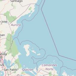
Map view of Calauag Watershed Reservation

Use this park location map to pinpoint Calauag Watershed Reservation in Philippines, understand its exact geographic position, and read its mapped placement within the surrounding landscape more clearly.

Pigeon | © OpenStreetMap contributors

Location context for Calauag Watershed Reservation

Quezon
Park atlas

Compare regional forest reserves and connected lowland rainforest terrain in Quezon province

Explore Parks Near Calauag Watershed Reservation and Surrounding Protected Areas

Browse other protected areas and regional forest reserves situated across the hilly terrain surrounding Calauag Watershed Reservation. Continuing into these adjacent locations reveals broader patterns of lowland rainforest preservation and regional watershed management across Luzon.
Nature reserveQuezon
About 4.9 km away#1 closest

Southeast

Lopez Watershed Forest Reserve: Protected Nature Reserve and Watershed Atlas of Quezon

A foundational rainforest landscape within the Quezon province protected network.

Lopez Watershed Forest Reserve is a significant nature reserve located in the rolling hills of southern Quezon, Philippines. This site preserves a continuous block of tropical lowland and lower montane forest, functioning as an essential watershed catchment area within the broader Luzon landscape. Learn about its institutional importance and its role as an early component of the Philippine protected area management framework.

Area
4.18 km²
Established
1940
Relief
Upland
Water
Minor water
Wildlife reserveQuezon
About 43 km away#2 closest

Northwest

Alabat Watershed Forest Reserve: Wildlife Reserve and Regional Watershed Geography in Quezon

Exploring the protected lowland rainforests of Alabat Island.

Located in Quezon, the Alabat Watershed Forest Reserve represents a significant wildlife reserve defined by its ridge and valley topography. The landscape serves as a protected catchment for the Langas River, maintaining essential lowland forest cover amidst the island environment. This entity provides a clear look at the ecological significance and mapped boundaries of a vital Philippine watershed and forest system.

Area
6.88 km²
Established
1987
Relief
Upland
Scope
Terrestrial
Protected areaCamarines Norte
About 48 km away#3 closest

East

Abasig-Matogdon Mananap Natural Biotic Area: Regional Geography and Protected Forest Terrain

A vital ecological reserve in the Bicol Region of Luzon

Located in Camarines Norte, the Abasig-Matogdon Mananap Natural Biotic Area protects critical lowland and montane rainforests surrounding Mount Labo. This area serves as a key component of the regional conservation landscape, defined by its steep volcanic terrain, numerous geothermal springs, and habitat for endemic species within the Philippine archipelago.

Area
54.2 km²
Established
2000
Relief
Mountain
Climate
Tropical
Protected landscapeQuezon
About 60 km away#4 closest

West

Quezon Protected Landscape: Mapping the Rainforests and Karst Terrain of Quezon Province

An essential protected landscape in the southern Sierra Madre mountain range.

Quezon Protected Landscape serves as a vital ecological corridor, featuring a rugged mix of karst topography, lowland rainforests, and underground water systems. Explore the geographic layout of this Philippine reserve, which encompasses symbolic summits, cascading waterfalls, and diverse endemic habitats within the southern Sierra Madre foothills.

Area
9.38 km²
Established
2003
IUCN
V
Relief
Mountain
Wildlife reserveQuezon
About 67 km away#5 closest

South

Mulanay Watershed Forest Reserve: Mapping Protected Lowland Rainforests in Quezon

A watershed conservation site on the Bondoc Peninsula

Spanning 474 hectares in the province of Quezon, the Mulanay Watershed Forest Reserve acts as a protected anchor for local biodiversity and hydrological health. The reserve preserves rolling, forest-covered hills that feed the Cawayan Creek, illustrating the importance of small, strategically managed protected lands within the larger Philippine conservation framework.

Area
4.74 km²
Established
1938
Relief
Upland
Water
Minor water
National parkPhilippines
About 72 km away#6 closest

East

Libmanan Caves National Park: Philippines National Park and Mapped Landscape

Explore protected area boundaries and regional geography.

Libmanan Caves National Park is a protected national park within the Philippines, offering a distinct focus for geographic discovery. This entry provides detailed context on its mapped landscape and its place within the archipelago's protected areas. Users can gain a clear understanding of the park's regional setting, facilitating atlas-style exploration and comprehension of its conservation significance within the Philippine geography.

Area
0.194 km²
Established
1934
IUCN
III
Relief
Upland
Wildlife reserveMarinduque
About 73 km away#7 closest

Southwest

Marinduque Wildlife Sanctuary: Map of the Protected Interior Forest

Exploring the essential wildlife habitats of Marinduque Island

Spanning 8,800 hectares of hilly terrain across five municipalities, the Marinduque Wildlife Sanctuary protects a critical block of forest. This reserve is recognized as a vital sanctuary for endemic Philippine species and forms a significant ecological backbone within the heart of the island landscape.

Area
88.28 km²
Established
2004
Relief
Mountain
Climate
Tropical
A horizontal watercolor painting of a mangrove forest with green canopies and characteristic prop roots rising from calm, reflective mudflats against a white background.
Protected landscapeCalabarzon
About 75 km away#8 closest

Southeast

Alibijaban Protected Landscape and Seascape: Coastal and Marine Geography

A protected island refuge in the Ragay Gulf of Calabarzon

The Alibijaban Protected Landscape and Seascape is a significant conservation site known for its undisturbed mangrove interior and thriving coral reef ecosystems. Its geography features flat terrain, sandy beaches, and complex seagrass meadows that attract diverse wildlife. This map-based overview provides detailed insights into the protected island's physical boundaries and unique marine-terrestrial intersection.

Area
10.56 km²
Established
1981
Relief
Lowland
Climate
Tropical

Common questions about visiting, size, designation, and location context for Calauag Watershed Reservation

Calauag Watershed Reservation FAQs for park facts, access, geography, and protected area context

Find quick answers about Calauag Watershed Reservation, including protected-area facts, park geography, trail and visitor context, and how the park fits into its surrounding country and regional landscape.
MoriAtlas Explorer

Continue Your Protected Areas Search Across the Global Atlas

Deepen your exploration by continuing the structured search for national parks and protected areas worldwide. Utilize the comprehensive filtering capabilities to compare different conservation landscapes and refine your understanding of global park geography. Discover more about the distribution and characteristics of protected natural areas.

Global natural geography