

Mori Atlas logo
Nature reserveCape Willoughby Conservation Park

Mapping the maritime heritage and cliffside terrain of the Dudley Peninsula headland

Cape Willoughby Conservation Park: A Protected Coastal Nature Reserve in South Australia

Cape Willoughby Conservation Park preserves a distinctive maritime headland at the eastern extremity of Kangaroo Island in South Australia. The protected area centers on the historic lighthouse complex and the surrounding low coastal cliffs that define this exposed maritime terrain. This geography provides an atlas perspective on the intersection of nineteenth century heritage buildings and the bracing windswept coastal landscapes facing the Southern Ocean.

coastal reserveKangaroo Islandlighthouse heritageheadlandsmall protected areaSouth Australia

Cape Willoughby Conservation Park

Nature reserve

Park overview

Structured park overview, official facts, and landscape profile for Cape Willoughby Conservation Park

Cape Willoughby Conservation Park park facts, protected area profile, and essential visitor context

Review the core facts for Cape Willoughby Conservation Park, including designation, size, terrain, visitor scale, habitats, and operating context in one park-focused overview.

About Cape Willoughby Conservation Park

Cape Willoughby Conservation Park lies on the far eastern side of Kangaroo Island, occupying a narrow coastal strip on the north shore of the Dudley Peninsula. Although the park is modest in extent, its location at the eastern end of the peninsula gives it a notably exposed position relative to Backstairs Passage and the passage of vessels between Kangaroo Island and the South Australian mainland coast. The reserve's identity is inseparable from the Cape Willoughby Lighthouse complex that occupies its eastern end and dominates the visitor experience.

The park's land base consists of section 412 within the Hundred of Dudley, a cadastral unit that was previously part of the larger Cape Hart Conservation Park. That earlier reserve was originally proclaimed in 1971 as the Cape Hart National Park under South Australia's National Parks Act 1966, and was later divided to create both the Cape Willoughby and Lesueur conservation parks in 2002. This history means the present-day Cape Willoughby Conservation Park is in effect a reconfigured fragment of an older protected-area footprint, rather than a freshly proclaimed reserve.

The park is bounded by the coastline to the north and east, with the lightstation precinct and an access road forming the spine of visitor movement through the site. Two of the former lighthouse keepers' cottages have been repurposed as visitor accommodation, supporting overnight stays tied directly to the heritage experience. A walking trail, known as the Cape Willoughby Lightstation heritage hike, links the cottages and key points around the headland, providing a focused way to engage with both the coastal scenery and the historic built environment.

Management of the park falls to the South Australian Department for Environment and Water, which integrates it with the broader network of Kangaroo Island reserves. As of the most recent published assessments, the park has not been assigned an IUCN protected-area category, reflecting the small scale and primarily heritage-oriented character of the reserve. Many visitors encounter the park not as a standalone wilderness destination but as the eastern endpoint of a broader Kangaroo Island itinerary centred on Penneshaw and the ferry arrival route from the mainland.

Quick facts and research context for Cape Willoughby Conservation Park

Cape Willoughby Conservation Park is located on the Dudley Peninsula on Kangaroo Island, in the Australian state of South Australia, roughly 27 kilometres south east of Penneshaw. The park covers about 18 hectares and lies in the gazetted locality of Willoughby. It was originally proclaimed on 21 January 1971 as part of the Cape Hart National Park, then sub-divided in 2002 into the present Cape Willoughby Conservation Park and the separate Lesueur Conservation Park. The reserve is managed by the South Australian Department for Environment and Water and overlays the historic Cape Willoughby Lighthouse precinct, with heritage cottages offering visitor accommodation and a heritage walking trail.

Protection and recognition

Examine terrestrial protection scope, designation history, and administrative records

Cape Willoughby Conservation Park Protection Status and Mapped Records

Terrestrial protection records outline the formal conservation status and administrative designation history assigned to Cape Willoughby Conservation Park. Structured management frameworks establish the documented framework without assuming specific conservation outcomes or international treaty listings.

Protection details

Protection scope
Terrestrial
Transboundary protection
No
Park context

Deeper park guide and search-rich context for Cape Willoughby Conservation Park

Cape Willoughby Conservation Park history, landscape, wildlife, and travel context

Explore Cape Willoughby Conservation Park through its history, landscape character, ecosystems, wildlife, conservation priorities, cultural context, and seasonal travel timing in a structured park guide built for atlas discovery and search intent.

Why Cape Willoughby Conservation Park stands out

Cape Willoughby Conservation Park is best known for protecting the headland setting around the Cape Willoughby Lighthouse, one of the oldest navigational lights in South Australia. The park frames the eastern extremity of the Dudley Peninsula, where rugged coastal cliffs face the open sea. The combination of small reserve size, dramatic maritime exposure, and built heritage gives the park a distinctive identity. Visitors associate the site primarily with the lightstation precinct and the sweeping coastal outlook rather than with extensive bushland or wilderness experiences, setting it apart from many larger South Australian conservation parks.
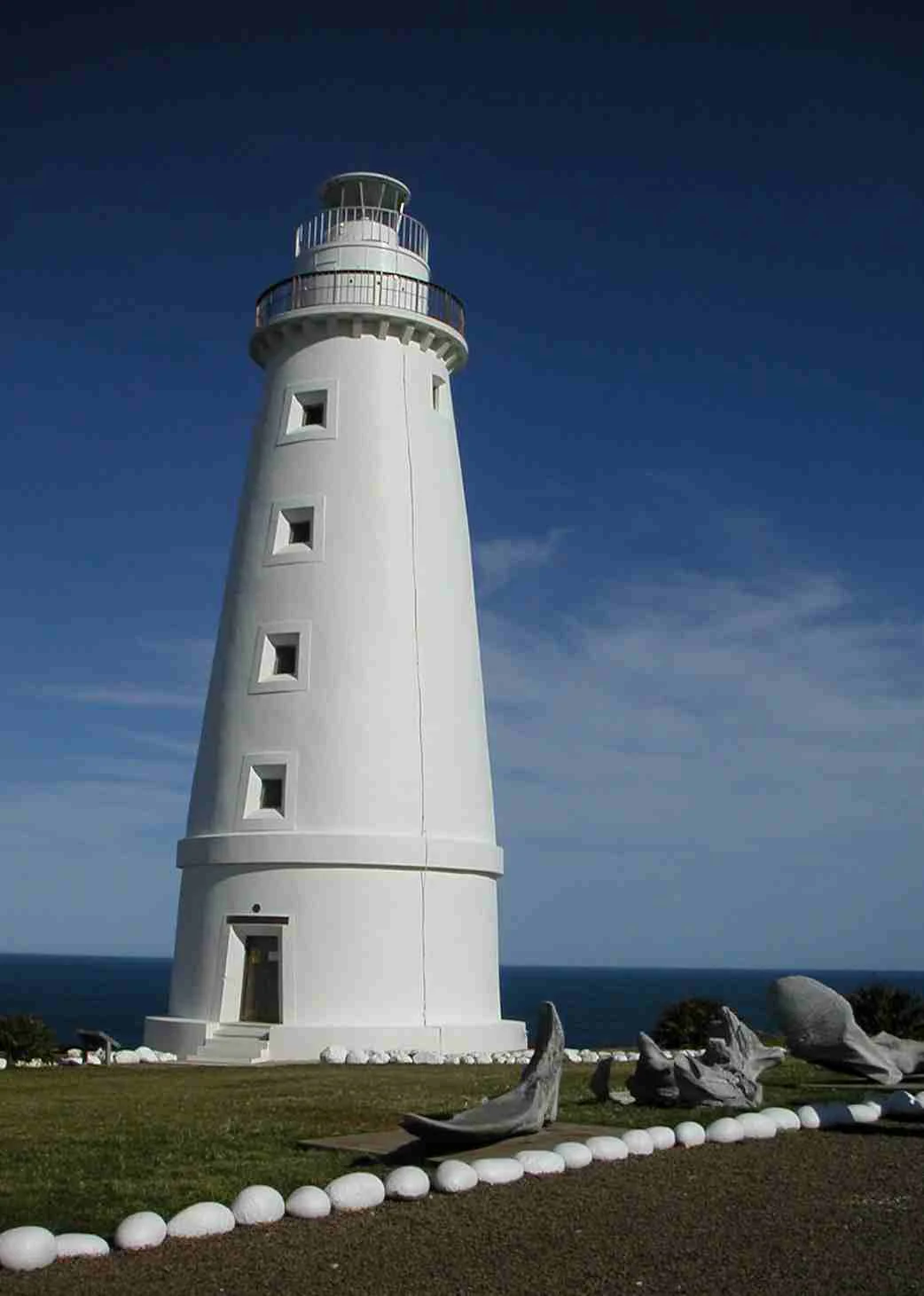
A white tapered lighthouse stands against a clear deep blue sky, with the ocean visible in the background and a stone-lined garden path in the foreground.
The historic Cape Willoughby Light, the primary landmark of the Cape Willoughby Conservation Park on Kangaroo Island.

Cape Willoughby Conservation Park history and protected-area timeline

The protected-area history of Cape Willoughby Conservation Park begins on 21 January 1971, when the land that now comprises it was included within the Cape Hart National Park, proclaimed under the National Parks Act 1966 of South Australia. The section of land forming the present-day park was added to the Cape Hart reserve after 1987, extending the original protected footprint eastward along the Dudley Peninsula coastline.

On 28 March 2002, the Cape Hart reserve was sub-divided into two separate conservation parks: the Cape Willoughby Conservation Park at the eastern end and the Lesueur Conservation Park further west. This administrative split created the park in its present form, with the Cape Willoughby Lighthouse precinct becoming the central feature of the new, smaller reserve.

Heritage context layers over this conservation history. The Cape Willoughby Lighthouse pre-dates the protected area by many decades, and the reuse of former keepers' cottages as visitor accommodation reflects an effort to integrate maritime heritage with nature-based recreation. The combination of formal protection of the headland and adaptive reuse of lighthouse buildings gives the park a dual identity as both a conservation reserve and a heritage tourism site.

Cape Willoughby Conservation Park landscape and geographic character

The landscape of Cape Willoughby Conservation Park is defined by its position at the exposed eastern end of the Dudley Peninsula. The reserve occupies a coastal strip bounded by the sea to the north and east, producing a setting in which maritime forces strongly shape both the scenery and the vegetation. The terrain is low and coastal, with cliff edges and headland profiles giving way to views across open water toward the South Australian mainland.

The park's interior is comparatively narrow, running back from the cliff line toward inland boundaries that abut neighbouring land. This shape concentrates the visitor experience along the coastline and around the lighthouse precinct, rather than across a wide hinterland. The combination of short cliff top edges, windswept coastal vegetation, and open sky lends the park a bracing, ocean-facing character typical of small South Australian headland reserves.

The road reaching the park, known as Cape Willoughby Road, approaches from the south west and terminates near the lighthouse buildings, reinforcing the sense of the park as a destination rather than a transit site. The walking trail that loops through and around the headland offers the principal means of engaging with the coastal topography beyond the immediate lighthouse precinct.

Cape Willoughby Conservation Park ecosystems, habitats, and plant life

Cape Willoughby Conservation Park is situated within the broader ecological context of Kangaroo Island, a region recognised nationally and internationally for its high proportion of native vegetation and relatively low incidence of introduced species. While the park itself is small and largely defined by its coastal headland setting, it contributes to the network of protected coastal habitats along the Dudley Peninsula.

The vegetation of the reserve is shaped by exposure to wind and salt, conditions that favour hardy, low-growing coastal plant communities. Such headland environments typically support small patches of remnant native coastal flora adapted to thin soils and salt spray, even where the surrounding mainland face has been altered by agriculture. Within the park, this restricted habitat mosaic contrasts with the more sheltered bushland inland on the Dudley Peninsula.

Although the park does not function as a flagship biodiversity reserve in the manner of larger Kangaroo Island parks, its protected status helps maintain a coastal vegetation corridor at the peninsula's eastern tip. This makes the reserve a small but ecologically meaningful part of the wider Kangaroo Island conservation landscape, complementing the larger blocks of habitat elsewhere on the island.

Cape Willoughby Conservation Park wildlife and species highlights

Wildlife values at Cape Willoughby Conservation Park are closely tied to its coastal headland environment rather than to expansive terrestrial habitats. Seabirds and shorebirds associated with the cliffs, rock platforms, and adjacent waters are likely users of the reserve, taking advantage of the open ocean outlook and the food resources available along this stretch of coastline.

In the broader context of Kangaroo Island, the Dudley Peninsula supports several of the island's characteristic fauna, and small coastal reserves like Cape Willoughby contribute to landscape connectivity along the peninsula's northern shore. However, the park's compact size and heritage-focused infrastructure mean that it is not positioned as a primary wildlife-viewing destination, and its role in fauna conservation is best understood as supporting rather than showcasing native animal populations.

Visitors interested in wildlife typically treat the park as part of a wider Kangaroo Island itinerary that includes larger reserves with more diverse fauna opportunities rather than as a standalone wildlife site.

Cape Willoughby Conservation Park conservation status and protection priorities

The conservation significance of Cape Willoughby Conservation Park lies in its role protecting a coastal headland at the eastern tip of the Dudley Peninsula, an area that has seen significant agricultural development across much of the surrounding landscape. By keeping the coastal strip and the lighthouse precinct in public ownership, the reserve helps maintain an undeveloped frontage along a sensitive stretch of South Australian coast.

Formal protection traces back to the original Cape Hart National Park proclamation in 1971, with the present park created through a 2002 reorganisation that separated the Cape Willoughby and Lesueur conservation parks. This ordered process of gazettal, subdivision, and ongoing management under the South Australian Department for Environment and Water provides the park with a consistent framework for land-use control, even though an IUCN reserve category had not yet been assigned as of the most recent assessment.

The park also illustrates a broader pattern in South Australian conservation where small, heritage-rich coastal reserves are retained alongside the state's larger flagship parks. While the Cape Willoughby reserve is modest in size, it preserves a piece of maritime coastal habitat and complements the network of protected areas across Kangaroo Island.

Cape Willoughby Conservation Park cultural meaning and human context

Cape Willoughby Conservation Park carries a layered human history shaped by maritime navigation, lighthouse operation, and the eventual repurposing of lightstation infrastructure for heritage-based recreation. The Cape Willoughby Lighthouse, one of South Australia's older navigational aids, sits at the heart of the park and lends the reserve a strong cultural identity that extends beyond its ecological role.

Former keepers' cottages within the park have been converted to visitor accommodation, allowing guests to stay within the historic precinct in a setting that recalls the working life of nineteenth- and early twentieth-century lighthouse staff. This adaptive reuse reflects an established approach in South Australia, where decommissioned or automated lightstations are integrated into tourism and conservation frameworks.

For visitors arriving on Kangaroo Island via Penneshaw, the Cape Willoughby precinct often represents the eastern cultural anchor of an itinerary that includes both natural and built heritage experiences across the island.

Top sights and standout views in Cape Willoughby Conservation Park

The standout features of Cape Willoughby Conservation Park cluster around its combination of coastal setting and lighthouse heritage. The Cape Willoughby Lighthouse complex, the headland cliffs, and the conversion of former keepers' cottages into accommodation collectively define the park's character and set it apart from purely wilderness-focused South Australian reserves.

The Cape Willoughby Lightstation heritage hike ties these elements together, providing an accessible route that links the historic buildings with the surrounding headland scenery. For many visitors, the park's appeal lies in this compact package of maritime history, exposed coastline, and quiet low-impact accommodation within a protected-area setting.

Best time to visit Cape Willoughby Conservation Park

Cape Willoughby Conservation Park can be visited year-round, with the experience shaped strongly by weather and sea conditions rather than by a strict seasonal window. The exposed coastal location means that visitors should generally expect variable wind and weather, and calmer days tend to bring clearer views across Backstairs Passage toward the mainland.

Wildflower displays and greener coastal vegetation on the Dudley Peninsula are typically associated with the cooler and wetter months, while warmer periods bring drier conditions and a more stripped-back headland appearance. Inland visitors often plan trips for the warmer half of the year, but the park itself remains accessible whenever access roads and accommodation are open. Choosing a period of settled weather, rather than a specific calendar window, usually delivers the most rewarding experience at this windswept reserve.

Monthly climate preview

Long-term representative monthly temperature and precipitation rhythm for Cape Willoughby

Cape Willoughby Conservation Park Climate Normals and Annual Temperature Patterns

Representative coordinates record warm summer daytime highs alongside cooler winter months and variable monthly precipitation rhythms across the protected landscape. Examining the complete twelve-month climatology profile reveals precise seasonal variations and long-term climate normals for the conservation area.
Annual mean16 °C
13 °C19 °C
Jan19°
Feb19°
Mar18°
Apr17°
May16°
Jun14°
Jul13°
Aug13°
Sep14°
Oct15°
Nov16°
Dec17°
Warmest month
February

18.8 °C

Coolest month
August

13.1 °C

Wettest month
June

2.1 mm/day

Driest month
December

0.7 mm/day

Park location guide

Geography guide, regional context, and park location map for Cape Willoughby Conservation Park

Cape Willoughby Conservation Park park geography, regions, and map view in Australia

Understand where Cape Willoughby Conservation Park sits in Australia through a broader geographic reading of the surrounding landscape, nearby location context, and its mapped position within the national park landscape.

How Cape Willoughby Conservation Park fits into Australia

Australia is a constitutional monarchy and federal parliamentary democracy comprising six states and ten territories. With a population of nearly 28 million, it is one of the world's most urbanised countries, with most people concentrated on the eastern seaboard. The country has a high Human Development Index and is known for its cultural diversity, ancient Aboriginal heritage, and unique wildlife.

Wider geography shaping Cape Willoughby Conservation Park in Australia

Australia occupies the entire Australian continent, the island of Tasmania, and numerous smaller islands. It is the world's flattest and driest inhabited continent, featuring vast deserts in the interior (the Outback), tropical rainforests along the eastern coast, and a coastline bordering the Indian and Pacific Oceans.

Map view of Cape Willoughby Conservation Park

Use this park location map to pinpoint Cape Willoughby Conservation Park in Australia, understand its exact geographic position, and read its mapped placement within the surrounding landscape more clearly.

Pigeon | © OpenStreetMap contributors

Location context for Cape Willoughby Conservation Park

South Australia

Visual exploration of coastal headlands, lighthouse architecture, and marine terrain

Cape Willoughby Conservation Park Photos and Landscape Scenery

Visual documentation captures the rugged coastal terrain and historic maritime architecture defining Cape Willoughby Conservation Park on Kangaroo Island. Detailed photography reveals exposed headland vegetation, low sea cliffs, and the nineteenth-century lightstation precinct within this protected coastal reserve.

A white tapered lighthouse stands against a clear deep blue sky, with the ocean visible in the background and a stone-lined garden path in the foreground.

Park atlas

Compare coastal terrain, headland reserves, and connected protected landscapes across the region

Explore Other Parks Near Cape Willoughby Conservation Park and Surrounding Regional Reserves

Continue exploring regional conservation areas and nearby national parks after reviewing Cape Willoughby Conservation Park. Comparing adjacent coastal reserves and protected landscapes provides valuable geographic context for the surrounding region.
Nature reserveSouth Australia
About 20 km away#1 closest

West

Dudley Conservation Park: Geography and Protected Habitat in South Australia

Nature reserve on Kangaroo Island with unique mallee woodland ecosystems.

Dudley Conservation Park represents a key protected area on the eastern edge of Kangaroo Island. This reserve is managed for its scientific importance, safeguarding specialized mallee scrub habitat and varied geological features including rocky limestone ridges and sandy coastal-influenced terrain.

Area
17.68 km²
Established
1970
IUCN
Ia
Relief
Upland
National parkSouth Australia
About 25 km away#2 closest

North

Deep Creek National Park: Protected Coastal Terrain and Geographic Context in South Australia

Discover South Australia's largest remaining natural vegetation area.

Deep Creek National Park offers a unique protected landscape on South Australia's Fleurieu Peninsula, extending 18 kilometers along the rugged coast. This national park is renowned for its rolling hills, gullies, and dramatic views across Backstairs Passage to Kangaroo Island. It serves as a crucial conservation area, preserving the largest continuous segment of natural vegetation in a region largely transformed by development, making its geography and protected status highly significant.

Area
44.96 km²
Established
1971
IUCN
II
Relief
Mixed relief
Wildlife reserveSouth Australia
About 32 km away#3 closest

Northeast

Eric Bonython Conservation Park: Protected Wildlife Reserve on the Fleurieu Peninsula

Mapping native forest landscapes in South Australia

Eric Bonython Conservation Park represents a significant protected area within South Australia. Covering a compact footprint on the Fleurieu Peninsula, this wildlife reserve preserves a mature messmate stringybark forest and rare native flora, functioning as a vital reference site for original regional ecology.

Area
0.06 km²
Established
1960
IUCN
Ia
Relief
Upland
Marine protected areaSouth Australia
About 48 km away#4 closest

South

Murray Commonwealth Marine Reserve: South Australia Marine Protected Area and Map

Deep-sea canyon geography and critical marine wildlife sanctuary

Spanning from the continental shelf to the depths of the Indian Ocean, the Murray Commonwealth Marine Reserve protects one of Australia's most significant submarine canyon systems. The reserve is essential for its role as a seasonal sanctuary for southern right whales and its complex, deep-water topography that supports diverse marine ecosystems across thousands of square kilometers.

Area
25,803 km²
Established
2007
IUCN
VI
Relief
Lowland
Wildlife reserveSouth Australia
About 49 km away#5 closest

West

Cape Gantheaume Conservation Park: Coastal Landscapes and Protected Area Atlas

South Australia wildlife reserve mapping and geography

Discover the geographic layout of Cape Gantheaume Conservation Park in South Australia. This protected area on Kangaroo Island features a distinct transition between the inland Murray Lagoon wetlands, expansive dune systems at D'Estrees Bay, and the offshore environment of Pelorus Islet, offering a comprehensive view of southern coastal terrain.

Area
42.13 km²
Established
1971
IUCN
Ia
Relief
Lowland
State or regional parkKangaroo Island
About 50 km away#6 closest

West

Cygnet Estuary Conservation Park: Protected Estuarine Geography and Mapped Wetlands

A focused coastal reserve on the shores of Kangaroo Island

Located on the northern side of Kangaroo Island, Cygnet Estuary Conservation Park provides a protected zone for tidal lagoons and river-mouth mudflats. The park serves as a key example of habitat-focused conservation, preserving the unique transition zone where the Cygnet River meets Nepean Bay. This mapped area highlights the subdued coastal landforms and fringing estuarine vegetation characteristic of South Australia's sheltered shores.

Area
1.39 km²
Established
2014
IUCN
III
Relief
Lowland
Nature reserveSouth Australia
About 50 km away#7 closest

Northwest

Busby Islet Conservation Park: Coastal Protected Area and Nature Reserve Mapping

Geography of a crucial seabird sanctuary in Nepean Bay

Busby Islet Conservation Park is a protected island reserve in South Australia known for its role as a breeding ground for Australian pelicans, cormorants, and various shorebird species. As a strict nature reserve, this low-lying rocky outcrop stands as a vital migratory wader roost along the north coast of Kangaroo Island, preserving essential coastal habitats through its long-standing protected status.

Area
0.17 km²
Established
1967
IUCN
Ia
Relief
Lowland
Nature reserveSouth Australia
About 58 km away#8 closest

Northeast

Gum Tree Gully Conservation Park: Protected Habitat and Landscape Geography

Nature reserve within the southern Mount Lofty Ranges

This nature reserve in South Australia protects a specific gully system within the Hindmarsh Tiers. Established as a focal point for the recovery of the endangered southern emu-wren, the park preserves a remnant bushland pocket that is vital for regional biodiversity conservation and landscape mapping.

Area
1.11 km²
Established
2010
IUCN
III
Climate
Mediterranean

Common questions about visiting, size, designation, and location context for Cape Willoughby Conservation Park

Cape Willoughby Conservation Park FAQs for park facts, access, geography, and protected area context

Find quick answers about Cape Willoughby Conservation Park, including protected-area facts, park geography, trail and visitor context, and how the park fits into its surrounding country and regional landscape.
MoriAtlas Explorer

Continue Your Protected Areas Search Across the Global Atlas

Deepen your exploration by continuing the structured search for national parks and protected areas worldwide. Utilize the comprehensive filtering capabilities to compare different conservation landscapes and refine your understanding of global park geography. Discover more about the distribution and characteristics of protected natural areas.

Global natural geography