

Why Ciénaga Grande de Santa Marta stands out
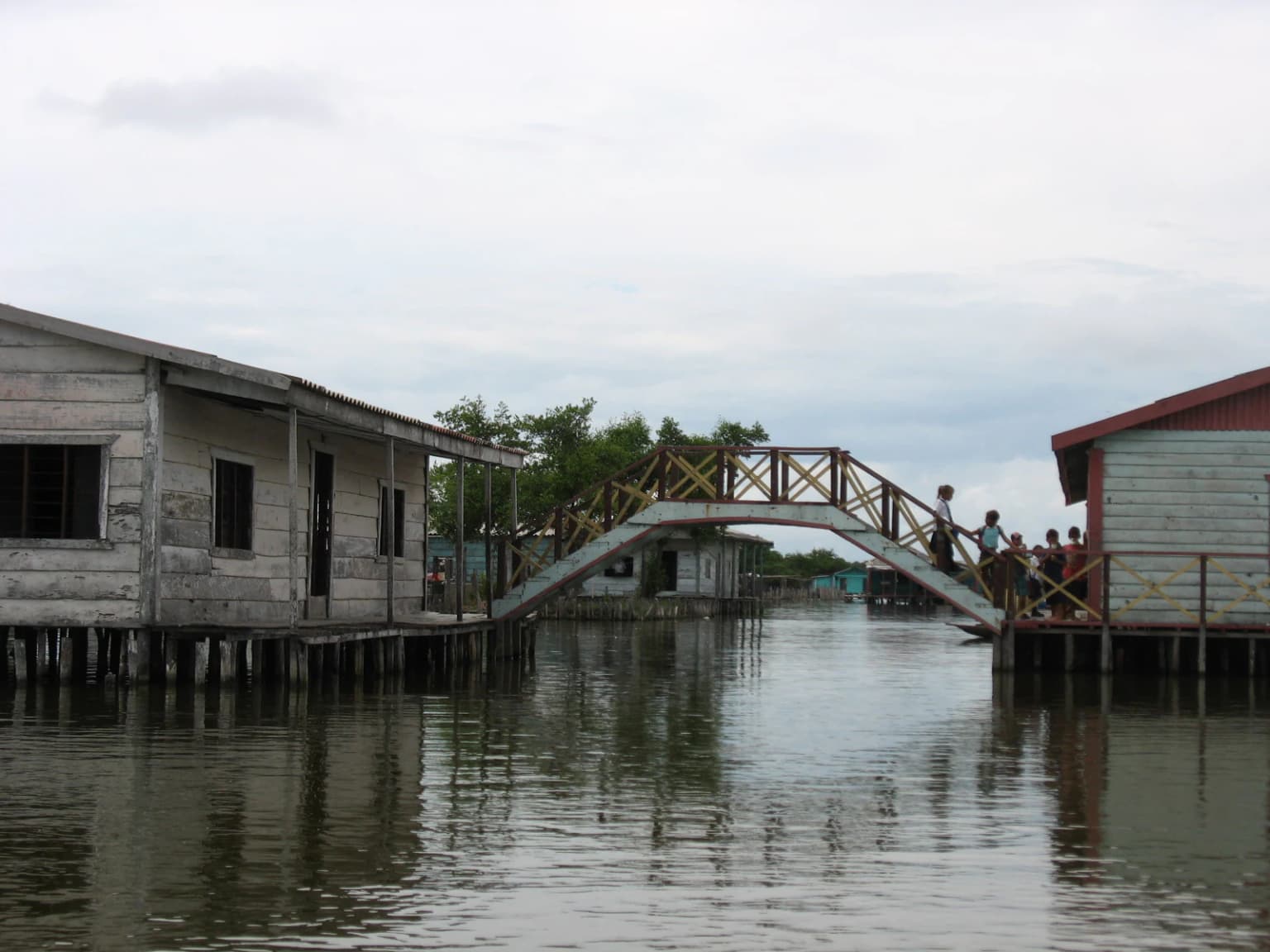
Ciénaga Grande de Santa Marta is best known as Colombia's largest coastal wetland and one of the most extensive marsh systems on the Caribbean coast of South America. Its designation as a Ramsar Wetland of International Importance underscores its global significance as a habitat for migratory waterfowl and shorebirds. The wetland's unique position at the confluence of the Magdalena River system and the Caribbean Sea creates a rich estuarine environment with mangroves, floating vegetation, and extensive lagoon systems. The area is also notable for its cultural landscape, featuring traditional palafitos stilt villages that sit atop the shallow waters, representing a distinctive form of human settlement adapted to the marsh environment.
Ciénaga Grande de Santa Marta history and protected-area timeline
The development of Ciénaga Grande de Santa Marta as a protected wetland area is relatively recent in its institutional history, with the Ramsar designation in 1998 marking its formal recognition as a wetland of international importance. However, the marsh system has been shaped by significant human intervention over the preceding decades, most notably the construction of the narrow sandy spit in the 1950s that now separates the marsh from the Caribbean Sea. This artificial barrier, built to stabilize the coastline and facilitate coastal settlement, fundamentally changed the hydrological dynamics of the wetland system. The marsh has long been central to the economic and cultural life of the surrounding region, with communities settlement patterns deeply intertwined with the seasonal flooding and recession of the waters. The construction of coastal Route 90 along the sandy spit created a transportation corridor connecting Barranquilla and Santa Marta, bringing increased development pressure to the area. The formal Ramsar listing in 1998 brought international attention to the wetland's conservation value and initiated more systematic efforts to balance human use with ecological preservation.
Ciénaga Grande de Santa Marta landscape and geographic character
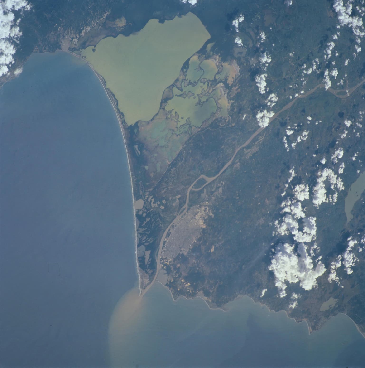
The landscape of Ciénaga Grande de Santa Marta is defined by its dual nature as both a river delta system and a coastal lagoon complex. The marsh extends across a vast flat plain, broken only by the shallow waters of its central lagoon and the intricate network of channels that distribute water throughout the system. The Sierra Nevada de Santa Marta rises dramatically in the background to the west, its snow-capped peaks providing a striking visual backdrop to the otherwise low-lying wetland landscape. To the east, the marsh interfaces with the distributary channels of the Magdalena River, which have deposited vast quantities of sediment over millennia to create the fertile deltaic plain. The narrow artificial spit that forms the marsh's Caribbean boundary is lined with coastal vegetation and provides the only solid ground along much of the marsh's sea-facing edge. The overall impression is one of vast horizontal expanse, with water and vegetation extending to the horizon in almost every direction, punctuated by the occasional raised structure of the traditional palafitos that dot the marsh's surface.
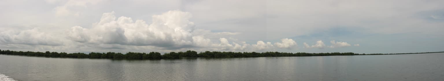
Ciénaga Grande de Santa Marta ecosystems, habitats, and plant life
The nature of Ciénaga Grande de Santa Marta centers on its function as a complex estuarine ecosystem where freshwater from the Magdalena River mixes with saltwater from the Caribbean Sea. This mixing creates a dynamic habitat with varying salinity zones that support diverse communities of plants and animals adapted to brackish conditions. The wetland's extensive vegetation includes mangroves along the channels and coastline, floating aquatic plants in the calmer lagoon areas, and flooded woodlands in the deeper sections. These vegetation communities serve as critical nurseries for fish and crustaceans, provide feeding grounds for waterfowl, and help filter sediments and nutrients from the water as it flows toward the sea. The wetland's position along the Caribbean flyway makes it an important seasonal destination for migratory birds traveling between North and South America, with the marsh providing crucial resting and feeding habitat during these long journeys.
Ciénaga Grande de Santa Marta wildlife and species highlights
Ciénaga Grande de Santa Marta supports rich wildlife communities associated with coastal wetland ecosystems. The wetland serves as an important habitat for numerous species of waterfowl and shorebirds, many of which follow migration routes along the Caribbean coast. The marsh's fish populations, including species that can tolerate varying salinity levels, support both resident aquatic wildlife and provide prey for birds and larger predators. The mangrove forests that fringe the channels and shoreline provide roosting and nesting sites for colonial waterbirds, while the open waters of the lagoon attract diving birds and fishing species. Although the source material provides limited specific species information, the Ramsar designation indicates the wetland meets international criteria for bird habitat significance, particularly for migratory waterfowl.
Ciénaga Grande de Santa Marta conservation status and protection priorities
Ciénaga Grande de Santa Marta holds formal conservation recognition as a Ramsar Wetland of International Importance, designated under the Ramsar Convention in 1998. This designation acknowledges the wetland's significance as a coastal ecosystem that supports biological diversity and provides important ecological services to the surrounding region. The Ramsar listing specifically recognizes the marsh's value as a habitat for waterfowl and its role in the broader Caribbean coastal ecosystem. As a designated Ramsar site, the wetland is part of an international network of protected wetlands committed to conservation and wise use. The marsh also provides important ecosystem services including flood control, water filtration, and coastal protection, functions that benefit the human communities living in the surrounding area.
Ciénaga Grande de Santa Marta cultural meaning and human context
Ciénaga Grande de Santa Marta is home to distinctive human communities whose traditional lifestyle is intimately connected to the marsh environment. The area is famous for its palafitos, traditional stilt houses built on wooden piles that raise living spaces above the shallow, permanently flooded waters of the marsh. These settlements, visible in aerial images of the wetland, represent an architectural adaptation to the watery landscape that has developed over generations. Communities like Nueva Venezia and Sitionuevo practice a lifestyle centered on fishing and activities tied to the marsh's seasonal rhythms. This cultural dimension adds significant value to the wetland beyond its ecological importance, demonstrating how human communities can develop sustainable relationships with complex coastal wetland environments.
Top sights and standout views in Ciénaga Grande de Santa Marta
Ciénaga Grande de Santa Marta stands as Colombia's premier coastal wetland, a vast 4,280 square kilometer estuary system where the Magdalena River meets the Caribbean. The Ramsar-designated wetland provides critical habitat for migratory birds and supports remarkable biodiversity in its brackish waters, mangroves, and floating vegetation. The landscape is defined by expansive marsh views, a prominent central lagoon connected to the sea through the La Barra channel, and the distinctive artificial spit that carries coastal Route 90 along the shoreline. Cultural highlights include the remarkable palafito villages, where communities have adapted to life on the water with stilted houses rising from the marsh's surface. The wetland's position between the Sierra Nevada de Santa Marta and the Caribbean Sea creates a striking backdrop where mountain peaks rise behind endless horizontal stretches of water and wetland vegetation.
Best time to visit Ciénaga Grande de Santa Marta
The wetland can be visited throughout the year, though the period from December through April typically offers drier conditions along Colombia's Caribbean coast. This season coincides with lower rainfall in the marsh region, which can make exploration more accessible and comfortable. The timing of bird migrations should be considered for those specifically interested in observing migratory waterfowl, with the boreal winter months often bringing the greatest variety of northern breeding species to the wetland. Local weather patterns and water levels influence the character of the marsh at different times of year, with the wet season bringing higher water levels that may affect access to certain areas.