
Why Cova-Paul-Ribeira da Torre Natural Park stands out
Cova-Paul-Ribeira da Torre Natural Park is best known for its dramatic volcanic crater landscape, which forms a distinctive basin surrounded by steep mountain walls in the interior of Santo Antão. The park protects one of the most botanically significant areas in Cape Verde, with exceptional concentrations of endemic species including Carex antoniensis, Conyza pannosa, Tornabenea insularis, Euphorbia tuckeyana, and Globularia amygdalifolia. The deep Paul Valley, carved by the Ribeira do Paul river, represents one of the most visually striking landscapes in the archipelago. The park also encompasses the impressive Ribeira da Torre valley, one of the deepest in Cape Verde, creating a landscape of extraordinary topographic contrast.
Cova-Paul-Ribeira da Torre Natural Park history and protected-area timeline
Cova-Paul-Ribeira da Torre Natural Park was established as one of Cape Verde's network of ten natural parks, reflecting the country's commitment to preserving its most ecologically and scenically significant landscapes. The park's creation acknowledged the exceptional botanical importance of the Cova Crater area and the surrounding volcanic highlands, which had long been recognized for their unique assemblages of endemic plant species. The formal designation of this area as a natural park provided institutional protection for habitats that had faced increasing pressure from agricultural expansion and firewood collection.
The park's inclusion on Cape Verde's tentative list for UNESCO World Heritage Site inscription in 2016 marked a significant milestone in its recognition at the international level. This tentative listing reflects assessment of the park's potential to meet criteria for outstanding universal value, particularly concerning its volcanic landscape and endemic biodiversity. The designation process has encouraged enhanced management attention and conservation planning for the area, while also raising awareness of the park's significance among both local communities and the international conservation community.
Cova-Paul-Ribeira da Torre Natural Park landscape and geographic character
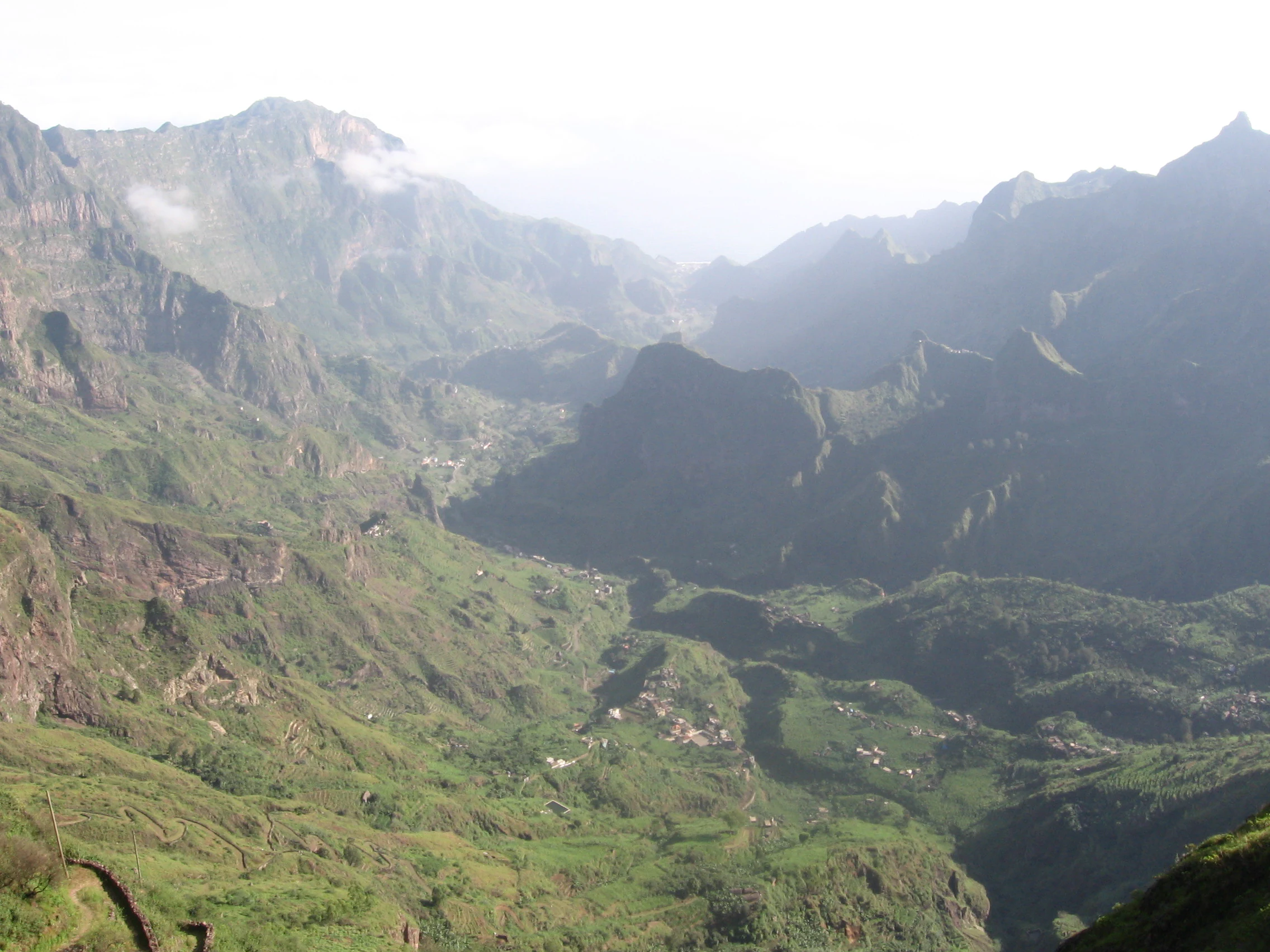
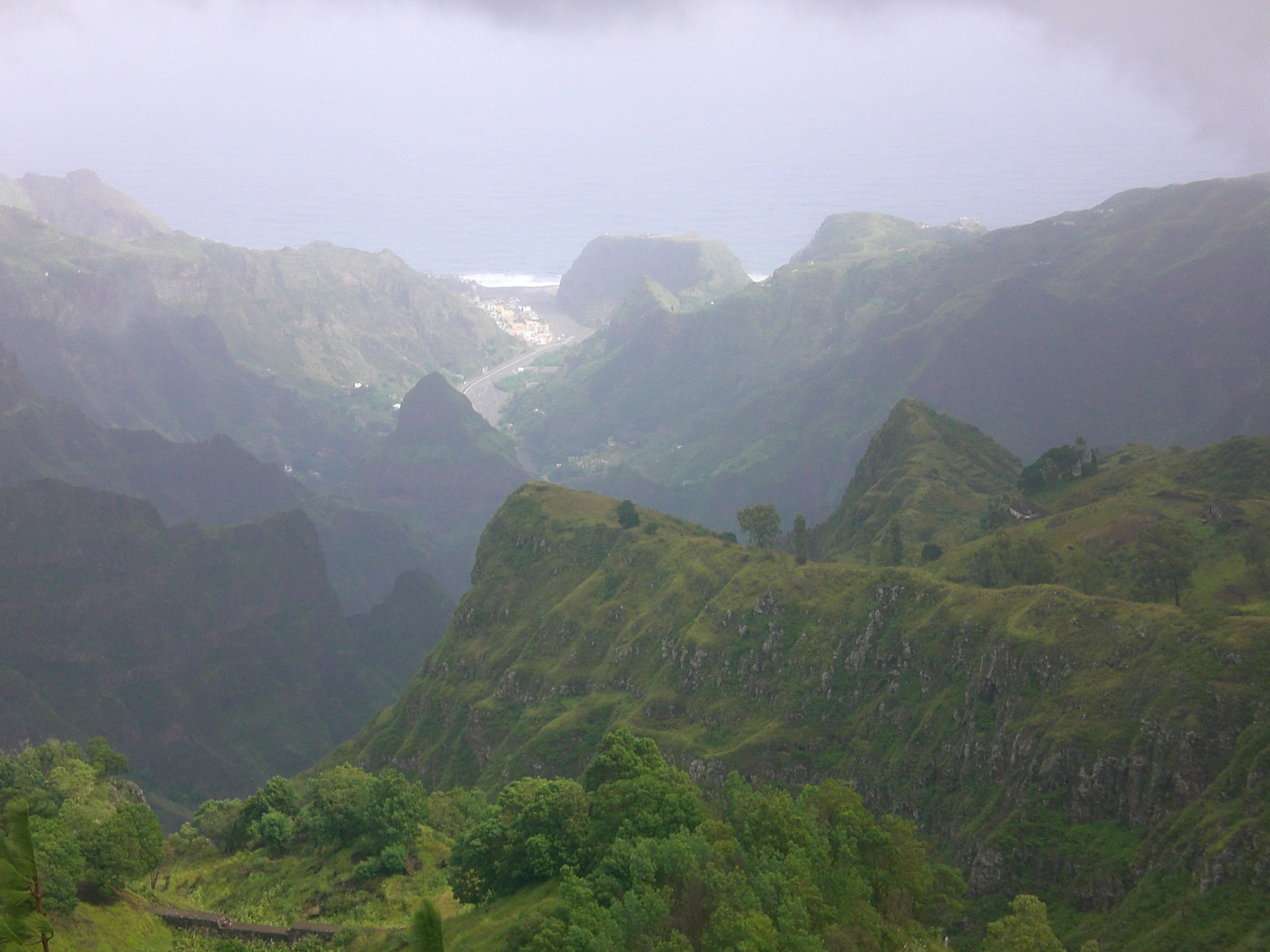
The landscape of Cova-Paul-Ribeira da Torre Natural Park is defined by its volcanic origins and the erosive forces that have sculpted the terrain over millions of years. The Cova Crater forms the park's central feature, a dramatic circular depression created by ancient volcanic activity and subsequently modified by erosion and weathering. Surrounding the crater, steep cliffs and escarpments rise toward the interior highlands, creating a landscape of remarkable vertical relief. The Ribeira da Torre valley, one of the deepest in Cape Verde, slices through the park's eastern portion, while the Ribeira do Paul valley carves a parallel course through the western sector, each descending from the highland divide toward the Atlantic coastal plain.
The elevation gradient from approximately 400 meters to 1,585 meters creates a landscape of remarkable diversity within a relatively small area. The upper elevations around Pico da Cruz are characterized by exposed volcanic rock, cliff faces, and sparse vegetation adapted to the more arid conditions. The valley floors and crater basin support more vegetated terrain where moisture accumulates and soils develop. The stark contrast between the cultivated lower slopes and the wild upland terrain creates a visually distinctive landscape that represents the interplay between natural volcanic processes and human agricultural activity in the Cape Verde highlands.
Cova-Paul-Ribeira da Torre Natural Park ecosystems, habitats, and plant life
The natural park encompasses a complex mosaic of forest and farmland that supports one of the richest assemblages of endemic plant species in Cape Verde. The vegetation reflects the elevational gradient and varying moisture conditions across the park, with different plant communities occupying the crater basin, valley floors, and exposed highland slopes. The park's botanical significance is underscored by the presence of numerous species classified as critically endangered, endangered, or vulnerable, reflecting the intense pressure that Cape Verde's native vegetation has faced from human activity and introduced species.
Among the park's notable endemic species are Carex antoniensis, a sedge adapted to moist highland habitats; Conyza pannosa, a compositae species found in rocky terrain; Tornabenea insularis, a member of the apiaceae family; Euphorbia tuckeyana, a succulent species; and Globularia amygdalifolia, a dwarf shrub characteristic of cliff and rock habitats. These species represent evolutionary lineages that have diversified within the Cape Verde archipelago over millions of years, adapted to the specific ecological conditions of the island's volcanic highlands. The park's protection of these species and their habitats is essential for preventing the extinction of plant taxa found nowhere else on Earth.
Cova-Paul-Ribeira da Torre Natural Park wildlife and species highlights
Cova-Paul-Ribeira da Torre Natural Park provides habitat for several endemic species of reptiles and birds that have evolved in isolation on Santo Antão island. The park's diverse terrain, ranging from cliff faces and crater margins to cultivated valley floors, supports varied faunal communities adapted to different ecological niches. While specific species are not detailed in available source material, the presence of endemic reptiles and birds reflects the evolutionary significance of this highland refuge on Santo Antão.
The combination of native forest remnants, scrub vegetation, and agricultural areas creates habitat heterogeneity that supports diverse wildlife communities. Endemic bird species in Cape Verde's highland areas typically include various passerines adapted to the island's specific conditions, while reptile diversity includes geckos and skinks that have diversified within the archipelago. The protection of these native species within the natural park is essential for maintaining the ecological integrity of Santo Antão's highland ecosystems.
Cova-Paul-Ribeira da Torre Natural Park conservation status and protection priorities
Cova-Paul-Ribeira da Torre Natural Park represents one of the most important conservation areas in Cape Verde due to its exceptional concentration of endemic plant species, many of which face critical threats of extinction. The park protects habitat for multiple species classified as critically endangered, endangered, or vulnerable under international conservation criteria, making it a priority area for botanical conservation in the archipelago. The inclusion of the park on Cape Verde's tentative list for UNESCO World Heritage inscription since 2016 reflects recognition of its outstanding universal value and the need for enhanced international conservation support.
The park's conservation significance extends beyond its botanical importance to include watershed protection, soil conservation, and the maintenance of landscape character that supports local agricultural communities. The deep valleys and steep terrain make the area particularly vulnerable to erosion when vegetation is disturbed, underscoring the importance of protective management that maintains forest cover and stabilizes slopes. Conservation challenges include balancing traditional agricultural use with habitat protection, managing introduced species that compete with native vegetation, and addressing the pressures from firewood collection and agricultural expansion that have historically impacted Cape Verde's native vegetation.
Cova-Paul-Ribeira da Torre Natural Park cultural meaning and human context
Cova-Paul-Ribeira da Torre Natural Park is situated in an area of Santo Antão that has been shaped by centuries of human occupation and agricultural activity. The Paul Valley and surrounding areas support communities whose livelihoods depend on agriculture and livestock husbandry, with farming terraces and irrigation systems modifying the landscape over generations. The park encompasses areas where traditional land use practices have created a mosaic of cultivated fields, orchards, and remnant natural vegetation that reflects the long relationship between human communities and the highland environment.
The park's three municipalities, Ribeira Grande, Paul, and Porto Novo, each contain communities with historical connections to the land now protected within the natural park. The Ribeira da Torre valley in particular has been an important corridor for movement between the interior highlands and the coastal areas, with the valley floor supporting agricultural activity that depends on water flowing from the highland catchment areas. Understanding this cultural context is important for effective park management that respects traditional uses while achieving conservation objectives.
Top sights and standout views in Cova-Paul-Ribeira da Torre Natural Park
Cova-Paul-Ribeira da Torre Natural Park offers visitors the opportunity to experience one of the most scenically dramatic landscapes in Cape Verde, with the Cova Crater providing a distinctive volcanic basin surrounded by mountain walls. The deep Paul Valley and the impressive Ribeira da Torre valley represent spectacular examples of fluvial erosion carving through volcanic terrain, creating landscapes of profound topographic relief. The park's exceptional botanical importance, with multiple critically endangered and endangered endemic plant species, makes it a significant destination for those interested in island biodiversity and conservation. The inclusion of the park on the UNESCO World Heritage Tentative List reflects its potential as a site of outstanding universal value.
Best time to visit Cova-Paul-Ribeira da Torre Natural Park
The natural park can be visited throughout the year, though the dry and cooler months from November to May typically offer more comfortable conditions for hiking and exploration of the highland terrain. The interior of Santo Antão experiences a semi-arid to arid climate, with rainfall concentrated in the late summer months from August to October when moisture from the Atlantic can bring periodic precipitation to the highlands. The vegetation is greenest during and shortly after the rainy season, while the dry season reveals more of the volcanic terrain's stark beauty. Visitors planning walks through the crater and valleys should be prepared for rugged terrain and variable weather conditions typical of highland environments.