

Mori Atlas logo
National parkCúc Phương National Park

Discover the geographic identity and protected boundaries of this national park.

Cúc Phương National Park: Vietnam National Park Atlas and Mapped Protected Landscape

Cúc Phương National Park stands as a significant protected area within Vietnam, located in Ninh Bình Province. This page serves as a detailed entry point for exploring its specific geographic scope and protected landscape context. Understand its role within the national park atlas, focusing on its mapped boundaries and regional natural geography.

karst landscapetropical forestlimestone cavesprimatesendangered speciesbiodiversity hotspot

Cúc Phương National Park

National park

Park overview

Structured park overview, official facts, and landscape profile for Cúc Phương National Park

Cúc Phương National Park park facts, protected area profile, and essential visitor context

Review the core facts for Cúc Phương National Park, including designation, size, terrain, visitor scale, habitats, and operating context in one park-focused overview.

About Cúc Phương National Park

Cúc Phương National Park represents Vietnam's premier protected area and a cornerstone of the country's conservation efforts. Located in Ninh Bình Province, the park encompasses approximately 22,000 hectares of karst mountain landscape in the foothills of the Annamite Range. The limestone geology has created a distinctive terrain of steep peaks, hidden valleys, and an extensive cave network that has been explored and inhabited for thousands of years. As the first national park in Vietnam, Cúc Phương carries significant historical and symbolic importance for the nation. The park serves as a living laboratory for tropical forest ecology and has become a model for protected area management in Southeast Asia. Beyond its ecological significance, the park offers visitors guided tours through its trail systems, access to cave explorations, and encounters with the three conservation centers that work to protect Vietnam's most threatened wildlife species.

Quick facts and research context for Cúc Phương National Park

Cúc Phương spans the karst foothills of the Annamite Range in Ninh Bình Province, approximately 150 kilometers southwest of Hanoi. The park features limestone mountains reaching 656 meters, deep valleys, and an extensive cave system carved into the karst geology. Average annual temperature is 21°C with annual rainfall exceeding 2,100mm across more than 200 rainy days. The dry season runs from November to February. As Vietnam's first national park established in 1962, Cúc Phương serves as the nation's flagship protected area and hosts three specialized conservation centers focusing on primates, carnivores and pangolins, and turtles.

Protection and recognition

Verifying terrestrial protection scope and official designation criteria within the global database.

Cúc Phương National Park Protection Status and Conservation Designation

Evaluating the terrestrial protection status of Cúc Phương National Park requires checking official designations, documented boundaries, and database alignments. Geographic records outline the legal management framework and verify whether transboundary agreements or international conservation recognitions apply to the area.

Protection details

Protection scope
Terrestrial
Transboundary protection
No
Park context

Deeper park guide and search-rich context for Cúc Phương National Park

Cúc Phương National Park history, landscape, wildlife, and travel context

Explore Cúc Phương National Park through its history, landscape character, ecosystems, wildlife, conservation priorities, cultural context, and seasonal travel timing in a structured park guide built for atlas discovery and search intent.

Why Cúc Phương National Park stands out

Cúc Phương is best known for its exceptional primate diversity and status as Vietnam's first national park. The park protects critically endangered langurs including Delacour's langur, golden-headed langur, and the black crested gibbon, which are the focus of the Endangered Primate Rescue Center established in 1993. The karst landscape with its dramatic limestone formations and accessible caves defines the visual character of the park. The ancient forest contains trees reaching 70 meters in height and supports a remarkable 2,000 species of vascular plants. The park also holds significant archaeological importance, with human habitation evidence dating back 7,000 to 12,000 years and artifacts including human graves, stone axes, and bone tools found throughout its cave systems.

Cúc Phương National Park history and protected-area timeline

Cúc Phương was designated as a forest reserve in 1960 and elevated to national park status in 1962, becoming Vietnam's first national park. The park was officially consecrated by President Ho Chi Minh, establishing a precedent for nature conservation in the newly independent nation. Archaeological evidence reveals that human habitation in the area dates back 7,000 to 12,000 years, with numerous caves within the park containing artifacts such as human graves, stone axes, pointed bone spears, oyster shell knives, and grinding tools. In 1789, the Quen Voi section of the park was the site of a significant battle during the civil war between Nguyễn Huệ and Thăng Long. More recently, the park has faced challenges related to human settlement, particularly involving the Muong ethnic minority who have historically lived, farmed, and hunted within the area. In 1987, approximately 500 Muong people were relocated outside the park to address issues of poaching and conflicting land use, though approximately 2,500 Muong continue to reside in and around the park boundaries.

Cúc Phương National Park landscape and geographic character

The landscape of Cúc Phương is dominated by spectacular karst limestone formations that rise abruptly from the surrounding terrain. These ancient limestone mountains, formed over millions of years, have been carved by water into dramatic peaks, ridges, and an extensive cave system. The elevation ranges from 150 meters in the valley floors to 656 meters at the summit of May Bac Mountain, also known as Silver Cloud Mountain. The valleys between the karst peaks provide sheltered habitats with rich soils and dense vegetation. Many of the caves are accessible for exploration and contain archaeological evidence of prehistoric human occupation. The landscape supports multi-layered tropical forest with canopy heights reaching 70 meters, creating a visually stunning environment of towering trees, epiphytes, lianas, and diverse understory vegetation.

Cúc Phương National Park ecosystems, habitats, and plant life

Cúc Phương occupies a critical position in two major ecoregions: the Northern Vietnam lowland rain forests and the Northern Indochina subtropical forests. This transitional position contributes to the park's remarkable botanical diversity, with approximately 2,000 species of vascular plants recorded within its boundaries. The forest structure features multi-layered canopies with trees displaying cauliflory, where flowers and fruits emerge directly from the trunk and main branches. The park contains remarkable specimens including Tetrameles nudiflora and Terminalia myriocarpa, the latter labeled as a thousand-year-old tree. Lianas and epiphytes are abundant, with orchids and ferns particularly diverse. The fern genus Asplenium is represented by species with notably long leaves. Beyond ornamental plants, the park contains species used for spices, medicines, and edible fruits, nuts, and shoots, reflecting the traditional relationship between local communities and the forest ecosystem.

Cúc Phương National Park wildlife and species highlights

The fauna of Cúc Phương is exceptionally diverse, with 97 mammal species, 300 bird species, 36 reptile species, 17 amphibian species, 11 fish species, 159 terrestrial mollusc species, and thousands of insect species documented. Primates are particularly well-represented, with macaques, gibbons, François's leaf monkey, and slow loris present in the forest canopy. The Endangered Primate Rescue Center focuses on protecting critically endangered species including Delacour's langur, golden-headed langur, and black crested gibbon. Other mammals include various bat species, porcupines, flying squirrels, and the rare black giant squirrel. Historically, the park supported Asiatic black bears, wild dogs, elephants, rhinos, and tigers, but these large mammals have been largely extirpated due to hunting pressure. Birdlife is equally impressive, with species ranging from bar-backed partridge and silver pheasant to hornbills, while migratory thrushes, flycatchers, and finches visit seasonally.

Cúc Phương National Park conservation status and protection priorities

Cúc Phương hosts three specialized conservation programs that address Vietnam's most pressing wildlife protection challenges. The Endangered Primate Rescue Center, established in 1993 with support from the Frankfurt Zoological Society, houses specimens of langurs, lorises, and gibbon species, focusing particularly on critically endangered primates. The Carnivore and Pangolin Conservation Program, established in 1995, targets small carnivores including civets, linsangs, and pangolins, running the region's only breeding program for Owston's civet, a species endemic to Indochina. The Turtle Conservation Center, established in 1998, works with some of Vietnam's most endangered turtles, including the Vietnamese pond turtle, which is nearly extinct in the wild. Many species in the park are listed in Vietnam's Red Book of Endangered Species, reflecting the critical conservation status of the region's biodiversity.

Cúc Phương National Park cultural meaning and human context

Cúc Phương has been inhabited by humans for thousands of years, with archaeological evidence in caves throughout the park dating back 7,000 to 12,000 years. The Muong ethnic minority have traditionally lived within what is now the park boundaries, maintaining agricultural and hunting practices tied to the landscape. Approximately 2,500 Muong continue to reside in and around the park, representing both a cultural dimension and a management challenge. The 1789 battle at Quen Voi between Nguyễn Huệ and Thăng Long forces adds a layer of historical significance to the park's cultural heritage. Traditional knowledge of forest resources, including medicinal plants and edible species, remains connected to local community practices.

Top sights and standout views in Cúc Phương National Park

The karst mountain landscape with its dramatic peaks and accessible caves provides the park's most distinctive visual character. The ancient forest with towering trees up to 70 meters and exceptional botanical diversity supports a remarkable 2,000 plant species. The three conservation centers offer unique opportunities to observe and learn about critically endangered Vietnamese wildlife, particularly primates, pangolins, and turtles. The archaeological significance of caves containing 7,000-year-old human artifacts adds a historical dimension rarely found in national parks. As Vietnam's first national park, Cúc Phương represents both the nation's conservation heritage and its ongoing commitment to protecting exceptional biodiversity.

Best time to visit Cúc Phương National Park

The optimal time to visit Cúc Phương is during the dry season from November to February, when rainfall is lowest and temperatures are cooler, particularly in December and January. This period offers more comfortable conditions for hiking and cave exploration, though morning fog and cooler valley temperatures should be anticipated. The wet season brings high humidity and frequent rain across more than 200 days annually, which can limit trail accessibility and make some areas difficult to explore. However, the wet season also brings lush, verdant vegetation and potentially more dramatic waterfall flows. Visitors seeking to see primates and other wildlife may find the dry season more favorable for wildlife viewing along trails, while the wet season showcases the forest at its most verdant.

Monthly climate preview

Long-term representative measurements of temperature and monthly precipitation

Cúc Phương National Park Climate Normals and Annual Weather Patterns

Representative baseline data captures measured monthly temperature ranges alongside shifting precipitation volumes across the coordinate. Reviewing the complete twelve-month profile provides deeper context on long-term climatic rhythms throughout the protected landscape.
Annual mean23 °C
16 °C28 °C
Jan16°
Feb18°
Mar21°
Apr25°
May27°
Jun28°
Jul28°
Aug27°
Sep26°
Oct23°
Nov20°
Dec16°
Warmest month
June

28.1 °C

Coolest month
January

15.7 °C

Wettest month
August

9.6 mm/day

Driest month
February

0.7 mm/day

Park location guide

Geography guide, regional context, and park location map for Cúc Phương National Park

Cúc Phương National Park park geography, regions, and map view in Vietnam

Understand where Cúc Phương National Park sits in Vietnam through a broader geographic reading of the surrounding landscape, nearby location context, and its mapped position within the national park landscape.

How Cúc Phương National Park fits into Vietnam

Vietnam, officially the Socialist Republic of Viet Nam, is a unitary communist state in Southeast Asia. It occupies roughly 331,000 square kilometres along the eastern edge of Mainland Southeast Asia, with a population exceeding 102 million. The country is bordered by China to the north, Laos and Cambodia to the west, and has maritime boundaries in the Gulf of Thailand and South China Sea.

Wider geography shaping Cúc Phương National Park in Vietnam

Vietnam occupies the eastern edge of Mainland Southeast Asia, stretching along the Gulf of Thailand to the southwest and the South China Sea to the east. The country is bordered by China to the north, and Laos and Cambodia to the west. It has a diverse landscape ranging from the Red River Delta in the north to the Mekong Delta in the south.

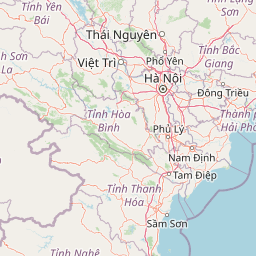
Map view of Cúc Phương National Park

Use this park location map to pinpoint Cúc Phương National Park in Vietnam, understand its exact geographic position, and read its mapped placement within the surrounding landscape more clearly.

Pigeon | © OpenStreetMap contributors

Location context for Cúc Phương National Park

Ninh Bình Province
Park atlas

Trace the regional geography and compare adjacent protected landscapes surrounding Vietnam's first national park.

Explore Nearby National Parks and Protected Areas Around Cúc Phương National Park

Expand your atlas exploration from Cúc Phương National Park to examine other national parks and protected areas across its surrounding regional geography, including similar karst landscapes and tropical forests. Compare the unique conservation values and geographic context of protected areas situated near Vietnam's first national park.
National parkThanh Hóa Province
About 73 km away#1 closest

South

Ben En National Park: Vietnam National Park Geography and Mapped Landscape Context

Explore protected area boundaries and regional terrain.

Ben En National Park represents a key protected natural area within Thanh Hóa Province, Vietnam. This detail page facilitates a structured discovery of its geographic features, mapped extent, and its significance as a national park. Dive into the atlas context to understand the park's landscape and its regional setting, offering a factual foundation for geographic exploration.

Area
147.35 km²
Established
1992
IUCN
II
Visitors
6.6K annual
National parkHanoi
About 88 km away#2 closest

North

Ba Vì National Park: Ancient Volcanic Mountains and Protected Landscape Near Hanoi

Discover the mapped geography and biodiversity of this national park.

Ba Vì National Park, a protected natural area near Hanoi, showcases a dramatic landscape shaped by ancient volcanic activity. The park features three significant peaks, including Vua Mountain, creating a distinct topographical profile. Spanning over 10,800 hectares, it is recognized for its ecological diversity, harboring a wealth of plant and animal species. This national park serves as a vital protected landscape, offering a unique opportunity for geographic exploration and understanding the natural terrain surrounding the Vietnamese capital.

Area
108.15 km²
Established
1991
IUCN
II
Relief
Mountain
Watercolor illustration of a wetland landscape with green trees and a pale sky
National parkNam Định Province
About 95 km away#3 closest

East

Xuân Thủy National Park: Protected Landscape Identity and Mapped Geography in Nam Định

Explore the national park's protected boundaries and regional landscape.

Xuân Thủy National Park serves as a vital protected landscape within Nam Định Province, Vietnam, offering users a clear point of entry for understanding its geographic identity. This page facilitates detailed exploration of its mapped park boundaries and the surrounding natural terrain, providing essential context for anyone interested in the regional geography of protected areas. Discover the specific landscape characteristics that define this national park and its place within Vietnam's conservation network.

Area
7,100 km²
Established
2003
IUCN
II
Relief
Lowland
National parkPhú Thọ Province
About 101 km away#4 closest

Northwest

Xuân Sơn National Park: Protected Mountain Landscape and Regional Geography

Mapping the southeastern edge of the Hoang Lien Mountains.

Delve into the protected landscape of Xuân Sơn National Park, a key national park situated in Phú Thọ Province, Vietnam. This area, covering about 150 square kilometers, is defined by its rugged mountainous terrain, featuring steep forested slopes and distinct ridgelines that contribute to the region's varied topography. As a protected national park, Xuân Sơn plays a crucial role in preserving the natural characteristics of the southeastern Hoang Lien Mountains. Its geographic setting is significant, acting as a transition zone between higher montane environments and the nearby lowland river systems, offering a unique perspective on Vietnam's diverse natural heritage.

Area
150.48 km²
Established
1986
IUCN
II
Relief
Mountain
National parkVĩnh Phúc Province
About 117 km away#5 closest

North

Tam Dao National Park: Vietnam's Mountain National Park and Biodiversity Hotspot

Explore mapped boundaries and regional landscape context.

Tam Dao National Park is a key protected area in northern Vietnam, defined by its rugged mountain terrain featuring over 20 peaks exceeding 1,000 meters. This national park is a vital habitat for diverse flora and fauna, including numerous endemic species, and showcases transitional forest ecosystems from tropical to montane zones. Understanding Tam Dao National Park involves exploring its geographic setting within Vĩnh Phúc Province and appreciating its role as a significant protected landscape.

Area
368.83 km²
Established
1996
IUCN
II
Relief
Mountain
National parkVietnam
About 146 km away#6 closest

East

Cát Bà National Park: Vietnam's Critically Endangered Species Sanctuary & Karst Landscape

Mapped protected area with diverse terrestrial and marine ecosystems.

As a critical national park in Vietnam, Cát Bà National Park protects a remarkable limestone karst landscape central to the Hạ Long Bay region. This area is renowned for its steep peaks, narrow valleys, and coastal mangrove environments, supporting a uniquely diverse array of flora and fauna. Its status as a protected area highlights its global importance for conservation, particularly as the exclusive habitat of the Cát Bà langur. Explore the mapped geography and ecological significance of this vital Vietnamese protected land.

Area
161.968 km²
Established
1986
IUCN
II
Relief
Highland
National parkNghệ An Province
About 178 km away#7 closest

Southwest

Pù Mát National Park: National Park Protected Landscape and Geographic Mapping

Explore Nghệ An Province's protected area context.

Pù Mát National Park is a key protected area situated in Nghệ An Province, Vietnam. This entry focuses on its role as a national park, detailing its mapped boundaries and geographic features. It serves as a vital point for understanding the distribution of protected lands and the natural landscape context within the broader regional atlas. Discover the specific geographic identity and atlas significance of Pù Mát National Park.

Area
911.13 km²
Established
2001
IUCN
II
Relief
Mountain
National parkHà Tĩnh Province
About 225 km away#8 closest

South

Vũ Quang National Park: Protected Landscape Identity and Geographic Context in Hà Tĩnh

National Park Discovery and Mapped Terrain Exploration

Investigate Vũ Quang National Park, a key protected area situated in Hà Tĩnh Province. This page provides detailed insight into the park's designation as a national park, focusing on its mapped boundaries, surrounding natural landscapes, and contribution to the regional geography. It serves as a vital resource for understanding the park's protected landscape characteristics and its place within Vietnam's atlas of conservation areas.

Area
550.28 km²
Established
2002
IUCN
II
Relief
Mountain

Common questions about visiting, size, designation, and location context for Cúc Phương National Park

Cúc Phương National Park FAQs for park facts, access, geography, and protected area context

Find quick answers about Cúc Phương National Park, including protected-area facts, park geography, trail and visitor context, and how the park fits into its surrounding country and regional landscape.
MoriAtlas Explorer

Continue Your Protected Areas Search Across the Global Atlas

Deepen your exploration by continuing the structured search for national parks and protected areas worldwide. Utilize the comprehensive filtering capabilities to compare different conservation landscapes and refine your understanding of global park geography. Discover more about the distribution and characteristics of protected natural areas.

Global natural geography