
Mori Atlas logo
State or regional parkDavis Lake Provincial Park

Mapped geography of freshwater lakes, forest canopies, and cascading mountain creeks

Davis Lake Provincial Park: A Protected Old-Growth Landscape in British Columbia

Davis Lake Provincial Park serves as a protected sanctuary within the Fraser Valley, defined by its intact stands of old-growth Western Hemlock and the active watercourse of Murdo Creek. This regional protected area offers a unique look at the terrain surrounding the southern end of Stave Lake. Visitors and map enthusiasts can trace the landscape transition from quiet lakeshores to the forested slopes where McDonald Falls creates a distinct natural landmark.

provincial parkBritish ColumbiaFraser Valleyold-growth forestWestern Hemlocklake recreation
A digital illustration featuring a multi-tiered waterfall cascading down a rocky mountainside into a green pool, framed by coniferous trees and ferns.

Davis Lake Provincial Park

State or regional park

Park overview

Structured park overview, official facts, and landscape profile for Davis Lake Provincial Park

Davis Lake Provincial Park park facts, protected area profile, and essential visitor context

Review the core facts for Davis Lake Provincial Park, including designation, size, terrain, visitor scale, habitats, and operating context in one park-focused overview.

About Davis Lake Provincial Park

Davis Lake Provincial Park sits in the Fraser Valley of southwestern British Columbia, northeast of the town of Mission and just east of the southern end of Stave Lake. Access is by an unmaintained gravel road that branches off Sylvester Road, which itself runs north from BC Highway 7, giving the park a deliberately low-key, lightly developed feel despite its relative proximity to the Lower Mainland.

The park is compact, covering roughly 185 acres, and is dominated by Davis Lake at its heart. A 1 km gravel spur reaches the south end of the lake, where modest campgrounds and small beaches form the focal point of visitor activity. The park has no major road-based infrastructure within its boundaries; arrival requires a walk-in approach that reinforces its quiet, semi-backcountry character. Because there are no campsites accessible directly by watercraft, even paddlers arriving by canoe or kayak need to combine their trip with a short hike to reach the camping areas.

Ecologically, Davis Lake Provincial Park stands out for the quality of its forest cover. A relatively untouched stand of old-growth Western Hemlock occupies portions of the park, unusually intact for an area this close to a major population center and the long history of forestry in the region. The forested landscape, combined with the lake and the surrounding creek systems, supports a notable bird community that includes sapsuckers, woodpeckers, and spotted owls.

Recreation in the park is simple and nature-focused. Visitors come primarily for canoeing and kayaking on Davis Lake, swimming from the small south-end beaches, fishing under permit, and hiking down to McDonald Falls on Murdo Creek. The falls are reached from the Lost Creek Forest Service Road, which continues east from Sylvester Road past the lake, and they give the park one of its most distinctive short hiking destinations.

Although the park is small and easy to overlook, it plays a meaningful role in the provincial parks system of southwestern British Columbia, offering both a sheltered old-forest environment and a calm freshwater setting within easy reach of Mission and the broader Fraser Valley.

Quick facts and research context for Davis Lake Provincial Park

Davis Lake Provincial Park is a small provincial park in British Columbia, located in the Fraser Valley Regional District northeast of Mission and east of the southern end of Stave Lake. Established in 1963 and governed by BC Parks, it is classified as an IUCN Category II protected area.

The park centers on Davis Lake and includes portions of Murdo Creek, where McDonald Falls is a defining feature. Its main ecological value lies in old-growth Western Hemlock forest and associated bird habitat, including woodpeckers, sapsuckers, and spotted owls.

Protection and recognition

Documented terrestrial protected area status and international recognition details

Davis Lake Provincial Park Protection Status and Management Scope

Davis Lake Provincial Park maintains a documented terrestrial protection status within the regional conservation network. Structured records outline the governing management scope and official recognition details associated with the protected landscape.

Protection details

Protection scope
Terrestrial
Transboundary protection
No
Park context

Deeper park guide and search-rich context for Davis Lake Provincial Park

Davis Lake Provincial Park history, landscape, wildlife, and travel context

Explore Davis Lake Provincial Park through its history, landscape character, ecosystems, wildlife, conservation priorities, cultural context, and seasonal travel timing in a structured park guide built for atlas discovery and search intent.

Why Davis Lake Provincial Park stands out

Davis Lake Provincial Park is best known for its lake-based, walk-in recreation experience and for protecting a relatively intact stand of old-growth Western Hemlock forest within an area otherwise heavily shaped by forestry in the Fraser Valley. McDonald Falls on Murdo Creek is another defining feature, drawing hikers into the park and providing one of its most recognizable scenic landmarks. The combination of accessible lake activities and surrounding old-growth forest gives the park an unusually natural character for a small, easily reached provincial park near Mission.
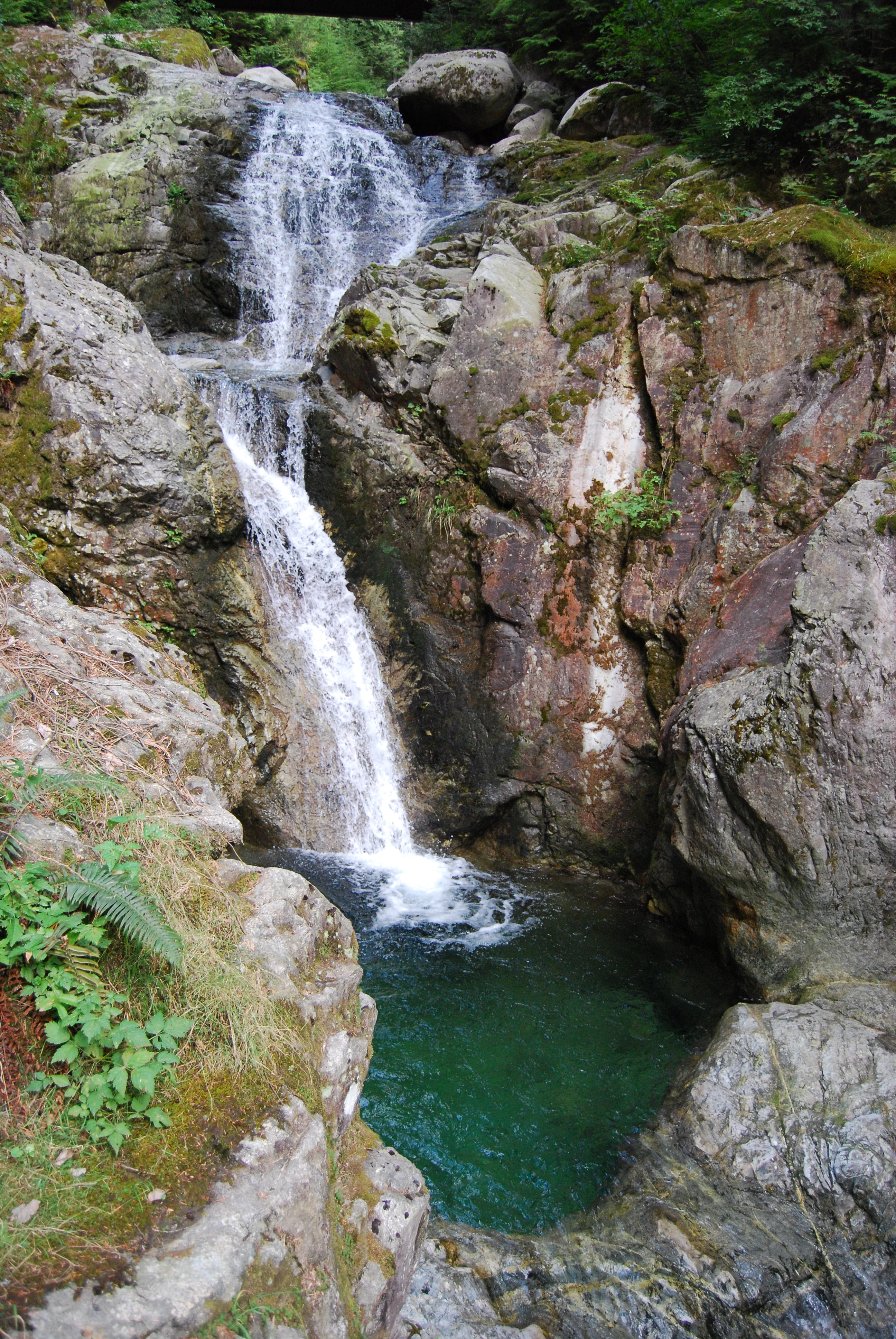
A multi-tiered waterfall cascading over dark rocky cliffs into a clear, deep green pool in a forested area.
McDonald Falls in Davis Lake Provincial Park.

Davis Lake Provincial Park history and protected-area timeline

Davis Lake Provincial Park was formally established as a protected provincial park in 1963, with its designation recorded in August of that year and the park coming into effect in October. Since then, it has been administered continuously by BC Parks as part of British Columbia's network of small, recreation- and conservation-oriented provincial parks.

Throughout its history, the park has remained lightly developed, maintaining a walk-in or rough-road access character rather than evolving into a major destination with extensive facilities. A 2018 report by the Vancouver Sun highlighted that the province still had significant work to do in strengthening park management, with Davis Lake Provincial Park cited as a particular example of a site where improvements were needed.

Davis Lake Provincial Park landscape and geographic character

The landscape of Davis Lake Provincial Park is shaped by a small freshwater lake ringed by dense coniferous forest, set in a valley setting east of the much larger Stave Lake. The terrain is varied enough to include a small lakeshore with modest beaches at the south end of Davis Lake, rising forested slopes around the shoreline, and steeper, more broken ground along Murdo Creek.

Murdo Creek descends through the eastern edge of the park and includes McDonald Falls, the park's most prominent natural landmark. The falls introduce an audible, visually dynamic element into what is otherwise a quiet, forest-dominated setting, with cascades framed by the same Western Hemlock forest that covers much of the surrounding slopes. The combination of lake, creek, falls, and old-growth canopy gives the park a layered topography that feels richer than its small footprint would suggest.

Davis Lake Provincial Park ecosystems, habitats, and plant life

Ecologically, Davis Lake Provincial Park belongs to the coastal Western Hemlock biogeoclimatic zone typical of southwestern British Columbia. Its most distinctive natural feature is a relatively untouched stand of old-growth Western Hemlock, a vegetation type that has become increasingly rare in the broader landscape due to long-standing forestry activity in the region.

Beyond the dominant coniferous canopy, the park includes freshwater habitats associated with Davis Lake and Murdo Creek, supporting both aquatic and shoreline ecological communities. The transition from standing water to creek to falls creates a small but ecologically diverse gradient within the park's boundaries, sustaining a mix of riparian, wetland-edge, and upland forest habitats.

The combination of mature forest structure, intact riparian corridors, and limited road-based disturbance gives Davis Lake Provincial Park more ecological continuity than many similarly sized parks in the Fraser Valley, allowing natural processes to shape forest composition, deadwood accumulation, and habitat complexity to a degree that is unusual for such an accessible location.

Davis Lake Provincial Park wildlife and species highlights

Wildlife at Davis Lake Provincial Park is strongly shaped by the presence of mature and old-growth coniferous forest, which provides critical habitat structure for cavity-nesting and forest-dependent bird species. The park is known to host sapsuckers, woodpeckers, and spotted owls, a community that reflects the continuing value of large, undisturbed Western Hemlock stands.

Sapsuckers and woodpeckers in particular benefit from the abundance of standing dead and decaying trees typical of old-growth forests, using them both for nesting and for foraging on wood-boring insects. Spotted owls, a species of high conservation concern in British Columbia, underscore the broader importance of retaining mature forest cover in the region and give the park's bird community a measure of ecological significance beyond its size.

The lake and creek environments also support fish populations, supporting the recreational fishery in the park under permit, and broader small-mammal and insect communities typical of coastal Western Hemlock ecosystems. Wildlife viewing is informal and incidental, woven into the experience of camping, paddling, and hiking rather than being a structured activity.

Davis Lake Provincial Park conservation status and protection priorities

Davis Lake Provincial Park plays a disproportionately important conservation role for its size because it protects a relatively intact stand of old-growth Western Hemlock forest in a landscape where such forests have been heavily reduced by industrial forestry. The park's old-growth patch contributes to habitat connectivity and provides refugia for species associated with mature forests, including sapsuckers, woodpeckers, and spotted owls.

Its IUCN Category II designation reflects a standard recognition of the park as a protected area under national and international classification systems, with goals centered on ecosystem protection and ecological integrity. Riparian habitat along Murdo Creek, including the McDonald Falls corridor, further supports aquatic and streamside ecological functions that are protected within park boundaries.

At the same time, the park illustrates ongoing management challenges. A 2018 Vancouver Sun report highlighted that provincial park management in British Columbia still requires significant improvement, with Davis Lake Provincial Park singled out as an example where stronger stewardship is needed to safeguard ecological values, maintain visitor safety, and ensure the park's old-growth and wildlife features are not degraded over time.

Davis Lake Provincial Park cultural meaning and human context

Davis Lake Provincial Park sits within the broader cultural landscape of the Fraser Valley, where outdoor recreation, forestry, and small lakeside communities have long shaped how residents relate to the surrounding land. The park's quiet, walk-in character aligns with a regional tradition of accessible but low-key nature experiences that do not require extensive facilities or large-scale tourism development.

The proximity of the park to Mission, combined with its old-growth forest, also places it within a wider local context in which local communities and outdoor enthusiasts have historically valued the remaining patches of mature Western Hemlock forest as much for their natural character as for their recreational setting.

Top sights and standout views in Davis Lake Provincial Park

Davis Lake Provincial Park's standout qualities center on its relatively untouched old-growth Western Hemlock forest, its tranquil lake-based atmosphere, and the scenic McDonald Falls on Murdo Creek. The combination of a paddling- and swimming-friendly lake with a hiking destination at the falls, all anchored by an intact coastal conifer forest, gives the park a layered experience despite its modest size.

Equally notable is the park's atmosphere of seclusion within easy reach of Mission and the Fraser Valley, made possible by its walk-in, rough-road access. This balance of accessibility and quiet is one of the park's most distinguishing traits within the British Columbia provincial park system.

Best time to visit Davis Lake Provincial Park

Davis Lake Provincial Park is best experienced during the drier months of late spring through early fall, when the unpaved access roads are most reliably passable and conditions on Davis Lake are most suited to paddling, swimming, and lakeside camping. Summer offers the warmest water and the most comfortable conditions for reaching McDonald Falls on foot from the park's access points.

Shoulder seasons in spring and early fall can also be attractive, with quieter campsites and active bird presence, including sapsuckers, woodpeckers, and spotted owls, becoming more noticeable as forest activity shifts. Winter conditions, with unmaintained gravel roads and cold, wet weather, generally make access and on-park comfort more challenging and are less suited to the park's main lake- and creek-based activities.
Monthly climate preview

Long term average temperature and monthly precipitation rhythm for Davis Lake Provincial Park

Davis Lake Provincial Park Climate Normals and Annual Weather Patterns

Historical climate data for Davis Lake Provincial Park records measured monthly variations in average temperature and precipitation across a representative coordinate point. Analyzing the complete twelve month climate profile clarifies long term environmental normals and localized atmospheric trends.
Annual mean5 °C
-4 °C15 °C
Jan-3°
Feb-3°
Mar
Apr
May
Jun12°
Jul15°
Aug15°
Sep12°
Oct
Nov
Dec-4°
Warmest month
July

15.4 °C

Coolest month
December

-3.7 °C

Wettest month
November

11.9 mm/day

Driest month
July

2.2 mm/day

Park location guide

Geography guide, regional context, and park location map for Davis Lake Provincial Park

Davis Lake Provincial Park park geography, regions, and map view in Canada

Understand where Davis Lake Provincial Park sits in Canada through a broader geographic reading of the surrounding landscape, nearby location context, and its mapped position within the national park landscape.

How Davis Lake Provincial Park fits into Canada

Canada is a federal parliamentary constitutional monarchy spanning North America from the Atlantic to the Pacific and Arctic Oceans. With a population of over 41 million, it is officially bilingual in English and French at the federal level. The country gained independence from the United Kingdom through a gradual process culminating in 1982.

Wider geography shaping Davis Lake Provincial Park in Canada

Canada occupies the northern portion of North America, sharing its longest international border with the United States. The country extends from the Atlantic Ocean to the Pacific Ocean and northward into the Arctic Ocean, giving it the longest coastline of any nation.

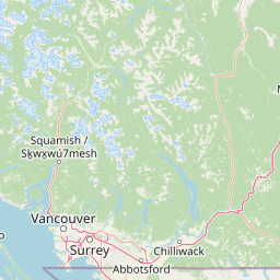
Map view of Davis Lake Provincial Park

Use this park location map to pinpoint Davis Lake Provincial Park in Canada, understand its exact geographic position, and read its mapped placement within the surrounding landscape more clearly.

Pigeon | © OpenStreetMap contributors

Location context for Davis Lake Provincial Park

British Columbia

Visual exploration of old growth forest and protected lake habitats

Davis Lake Provincial Park Photos, Landscapes, and Scenic Views

Visual documentation of Davis Lake Provincial Park reveals the dense Western Hemlock canopy, tranquil freshwater lakeshore, and cascading waters of McDonald Falls. Photographic records illustrate the protected terrain, dense coniferous habitats, and remote landscape character found across British Columbia.

A multi-tiered waterfall cascading over dark rocky cliffs into a clear, deep green pool in a forested area.

Park atlas

Compare nearby provincial parks and connected forest landscapes across the Fraser Valley

Other Parks Near Davis Lake Provincial Park and Surrounding Regional Protected Areas

Browse protected areas and forested valleys situated near Davis Lake Provincial Park to compare regional terrain features and old-growth habitats. Expanding the geographic scope reveals adjacent provincial reserves and similar wilderness settings across southwestern British Columbia.
A watercolor painting showing a soft-focus landscape with rolling green hills, distant mountains, and a central river or water feature.
State or regional parkBritish Columbia
About 12 km away#1 closest

Northwest

Golden Ears Provincial Park: Geographic Atlas and Protected Landscape Overview

Coast Mountains terrain and protected wilderness boundaries

Golden Ears Provincial Park is a major protected wilderness in British Columbia, defined by the twin peaks of the Golden Ears massif and vast glacial lake systems like Alouette and Pitt. This site serves as a vital ecological corridor where lowland forests meet high subalpine ridges. Explore the park through its mapped boundaries and diverse ecological zones within the Pacific Northwest mountain landscape.

Area
609 km²
Established
1967
IUCN
II
Visitors
956.5K annual
A soft watercolor painting of a landscape featuring a lake, low rolling hills in the background, and grassy vegetation along the foreground shoreline under a warm, pale yellow sky.
State or regional parkFraser Valley Regional District
About 12 km away#2 closest

Southwest

Rolley Lake Provincial Park: An Atlas of Protected Landscapes and Regional Geography

Lakeshore forest terrain and protected park geography

Delve into the geographic identity of Rolley Lake Provincial Park, a state-protected landscape in the Fraser Valley Regional District. This documentation traces the park's internal map, including its central freshwater lake, loop trail connectivity, and surrounding second-growth forest topography, providing essential context for understanding this localized wilderness zone.

Area
1.15 km²
Established
1961
IUCN
II
State or regional parkBritish Columbia
About 21 km away#3 closest

East

Kilby Provincial Park: Protected Riverfront Geography and Historic Sites in BC

A unique riparian landscape along the Harrison River

Kilby Provincial Park offers an intimate look at the flood plain geography of the Harrison River. The site features an elevated, boardwalk-linked heritage environment integrated with sandy riverfronts and seasonal wildlife corridors. This protected area stands out for its combination of historical pioneer preservation and river-based ecosystem monitoring within the Upper Fraser Valley region of British Columbia.

Area
0.03 km²
Established
1973
IUCN
II
Relief
Lowland
A watercolor illustration of a mountain landscape featuring soft rolling hills, evergreen trees, and low-lying vegetation on a white background.
State or regional parkBritish Columbia
About 27 km away#4 closest

Northwest

Pinecone Burke Provincial Park: Coast Mountain Wilderness and Protected Terrain Geography

Mapping a vast ecological corridor in British Columbia

Spanning over 38,000 hectares, Pinecone Burke Provincial Park represents a dramatic transition from the urban proximity of Coquitlam to the remote interiors of the southern Coast Mountains. The landscape is defined by its rugged relief, featuring subalpine meadows, deep freshwater systems, and historically significant forested slopes. This park provides a critical look at the complex topography of the Pacific Northwest, serving as a sanctuary for wildlife and a foundational piece of regional conservation.

Area
380 km²
Established
1995
IUCN
II
Relief
Mountain
State or regional parkBritish Columbia
About 35 km away#5 closest

East

Ferry Island Provincial Park: Geography, Riparian Terrain, and Protected River Boundaries

A study of Fraser River alluvial landscapes and provincial park land use

Ferry Island Provincial Park provides a rare protected island setting along the Fraser River in British Columbia. Spanning 29 hectares near the Agassiz-Rosedale Bridge, this Class C park represents an important alluvial riparian ecosystem within the heavily cultivated Fraser Valley, offering key insights into regional river-corridor geography and protected land management.

Area
0.29 km²
Established
1963
IUCN
II
Access
Access unknown
A watercolor painting showing a panoramic view of mountain peaks in the distance above green foothills and plains.
Protected landscapeWashington
About 39 km away#6 closest

South

Mount Baker, Snoqualmie National Forest: Mapped Geography and Protected Landscape Analysis

Exploratory atlas of Washington's primary Cascade Range wilderness

Delve into the structural geography of Mount Baker, Snoqualmie National Forest. This protected area corridor serves as a major ecological transition zone between the Puget Sound lowlands and the interior Cascades, characterized by extensive glaciers, wild river systems, and iconic stratovolcanoes that define the regional landscape of Washington state.

Area
6,978 km²
Established
1974
Relief
Mountain
Climate
Alpine
A horizontal watercolor painting showing a range of purple-tinted mountain peaks above a green forest and a light pinkish shoreline.
Wildlife reserveWashington
About 49 km away#7 closest

Southeast

Mount Baker Wilderness: Mapped Volcanic Peaks and Glacial Geography in Washington State

Protected wilderness boundaries in the Northern Cascades

Mount Baker Wilderness encompasses a vast mountain landscape characterized by an active stratovolcano and significant permanent snowfields. The terrain features a vertical gradient from dense west side conifer forests to exposed alpine summits, creating a distinct ecological corridor connected to neighboring protected areas in the Pacific Northwest.

Area
485.58 km²
Established
1984
IUCN
Ib
Relief
Mountain
A horizontal watercolor painting depicting a soft-toned landscape with green trees, rolling hills, a calm body of water, and distant pale mountains.
State or regional parkBritish Columbia
About 50 km away#8 closest

Southwest

Peace Arch Park: Mapped Geography and Protected Landscapes of the Canada and US Border

Coastal binational protected area in British Columbia

Peace Arch Park is a notable protected landscape positioned directly on the international border. This site acts as a continuous green space between Canada and the United States, offering an unusual study of territorial boundaries and coastal geography. Spanning manicured terrain and historic monument grounds, the park provides an essential vantage point for understanding land-based connectivity in the Pacific Northwest region.

Area
0.17 km²
Established
1939
Visitors
500K annual
Access
Easy access

Common questions about visiting, size, designation, and location context for Davis Lake Provincial Park

Davis Lake Provincial Park FAQs for park facts, access, geography, and protected area context

Find quick answers about Davis Lake Provincial Park, including protected-area facts, park geography, trail and visitor context, and how the park fits into its surrounding country and regional landscape.
MoriAtlas Explorer

Continue Your Protected Areas Search Across the Global Atlas

Deepen your exploration by continuing the structured search for national parks and protected areas worldwide. Utilize the comprehensive filtering capabilities to compare different conservation landscapes and refine your understanding of global park geography. Discover more about the distribution and characteristics of protected natural areas.

Global natural geography