
Mori Atlas logo
Nature reserveDer Meerbusch

Understanding the mapped boundaries and wetland terrain of a historic forest preserve in the Lower Rhine region.

Der Meerbusch Nature Reserve: Mapping the Ecological Geography of Protected Floodplain Forest Landscapes

(Naturschutzgebiet Der Meerbusch (NE-008))

Der Meerbusch serves as a significant protected nature reserve within the Lower Rhine region of Nordrhein-Westfalen, representing a rare fragment of ancient floodplain forest. This landscape is defined by its position along a silted former Rhine channel, where high groundwater levels sustain an intact alder swamp woodland. The reserve features a complex mosaic of reed stands, sedge beds, and open water bodies that provide vital habitat within the densely settled corridor between Düsseldorf and Krefeld.

floodplain forestswamp woodlandLower Rhinewetland reservealder carrbroadleaf forest
A flat-style vector illustration showing a winding river flowing through a lush mountain valley with a waterfall in the distance, stylized pine trees, and soft pastel colors.

Der Meerbusch

Nature reserve

Park overview

Structured park overview, official facts, and landscape profile for Der Meerbusch

Der Meerbusch park facts, protected area profile, and essential visitor context

Review the core facts for Der Meerbusch, including designation, size, terrain, visitor scale, habitats, and operating context in one park-focused overview.

About Der Meerbusch

Der Meerbusch is a forest reserve in the southern part of the city of Meerbusch, in the Rhine-Kreis Neuss district of North Rhine-Westphalia. Although the modern city of Meerbusch is largely suburban and lies in the densely populated corridor between Düsseldorf and Krefeld, this patch of woodland preserves a fragment of the ancient Lower Rhine floodplain forest. Small parts of the area also extend into the neighboring city of Kaarst.

The defining feature of the reserve is its setting in the marshland on the left bank of the Rhine, along the trace of a former river channel known as a Kendel, an old Rhine arm that silted up as the river shifted. This geological legacy is what keeps the soils waterlogged enough to support the wet forest communities that give the site its character. From south to north the reserve is drained by the Meerscher Mühlenbach, named for the water mill it once powered at Haus Meer; the Mühlenbach joins the Schackumer Bach at the southern edge of the forest before leaving the area toward the Strümper Busch to the north.

Ecologically, the reserve is structured in three concentric zones. In the wet southern and western margins, intact alder swamp woodland (Erlenbruchwald) thrives along the stream courses, interspersed with open water, sedge communities, and reedbeds; this is the most sensitive part of the site and the core of the nature reserve. Moving eastward, a transitional zone contains willow, poplar, and ash woodland mixed with shrubs and herbaceous plants, and some extensively grazed meadows and small arable plots are included in the protected area. Toward the drier eastern edges, outside formal protection, the forest is dominated by beech and pedunculate oak, reflecting the more typical managed woodland past of this part of the Rhine lowland.

Der Meerbusch sits within a much larger landscape protection area, the roughly 600 hectare Strümper Busch, Meerbusch, Stinkesbachaue complex, designated because of its significance as a relic of the Rhine's geological history. As a whole, it offers a small but ecologically rich refuge in a region where surviving examples of native floodplain forest are otherwise scarce.

Quick facts and research context for Der Meerbusch

Der Meerbusch is a mixed broadleaf forest in the Rhine floodplain of North Rhine-Westphalia, administered by the Rhein-Kreis Neuss district. Its core wetland portion was designated a nature reserve (Naturschutzgebiet) in 1987, and the broader forest has been part of a landscape protection area since 1990, together covering roughly 54 hectares of protected land within a historic woodland that once belonged to the estate of Haus Meer.

The reserve belongs to the Lower Rhine lowland system and is anchored by an old Rhine oxbow channel (Kendel). It is classified under IUCN Category IV as a habitat and species management area, and is registered in the World Database on Protected Areas as WDPA ID 162727. The area is embedded in the roughly 600 hectare landscape protection area Strümper Busch, Meerbusch, Stinkesbachaue, which is recognized for its geological significance as a relic of the Rhine's former course.

Protection and recognition

Explore terrestrial protection records and designation details for Der Meerbusch

Der Meerbusch Protection Status and Documented Conservation Scope

Terrestrial protection records for Der Meerbusch outline the established conservation scope and management framework. Official recognition data details the administrative boundaries and historical designation framework supporting the protected landscape.

Protection details

Protection scope
Terrestrial
Transboundary protection
No
WDPA ID
162727
Park context

Deeper park guide and search-rich context for Der Meerbusch

Der Meerbusch history, landscape, wildlife, and travel context

Explore Der Meerbusch through its history, landscape character, ecosystems, wildlife, conservation priorities, cultural context, and seasonal travel timing in a structured park guide built for atlas discovery and search intent.

Why Der Meerbusch stands out

Der Meerbusch is best known for its intact alder swamp woodland, an increasingly rare wet forest habitat along the Lower Rhine. The southern and western fringes of the forest, crossed by the Meerscher Mühlenbach and the Schackumer Bach, harbor a mosaic of alder carr, sedge beds, and reed stands that shelter moisture-loving plants, amphibians, and uncommon bird species. The open water surfaces scattered through the swamp woodland give the site a distinctive character rarely found elsewhere in this densely settled part of North Rhine-Westphalia. It is also notable as a clear example of how an ancient Rhine channel (a filled-in oxbow called a Kendel) continues to shape local ecology long after the river itself has moved on. The presence of this wet core within a larger, drier beech and oak forest, and within the urban shadow of Meerbusch, makes it a textbook case of small-scale habitat preservation in an industrialized landscape.
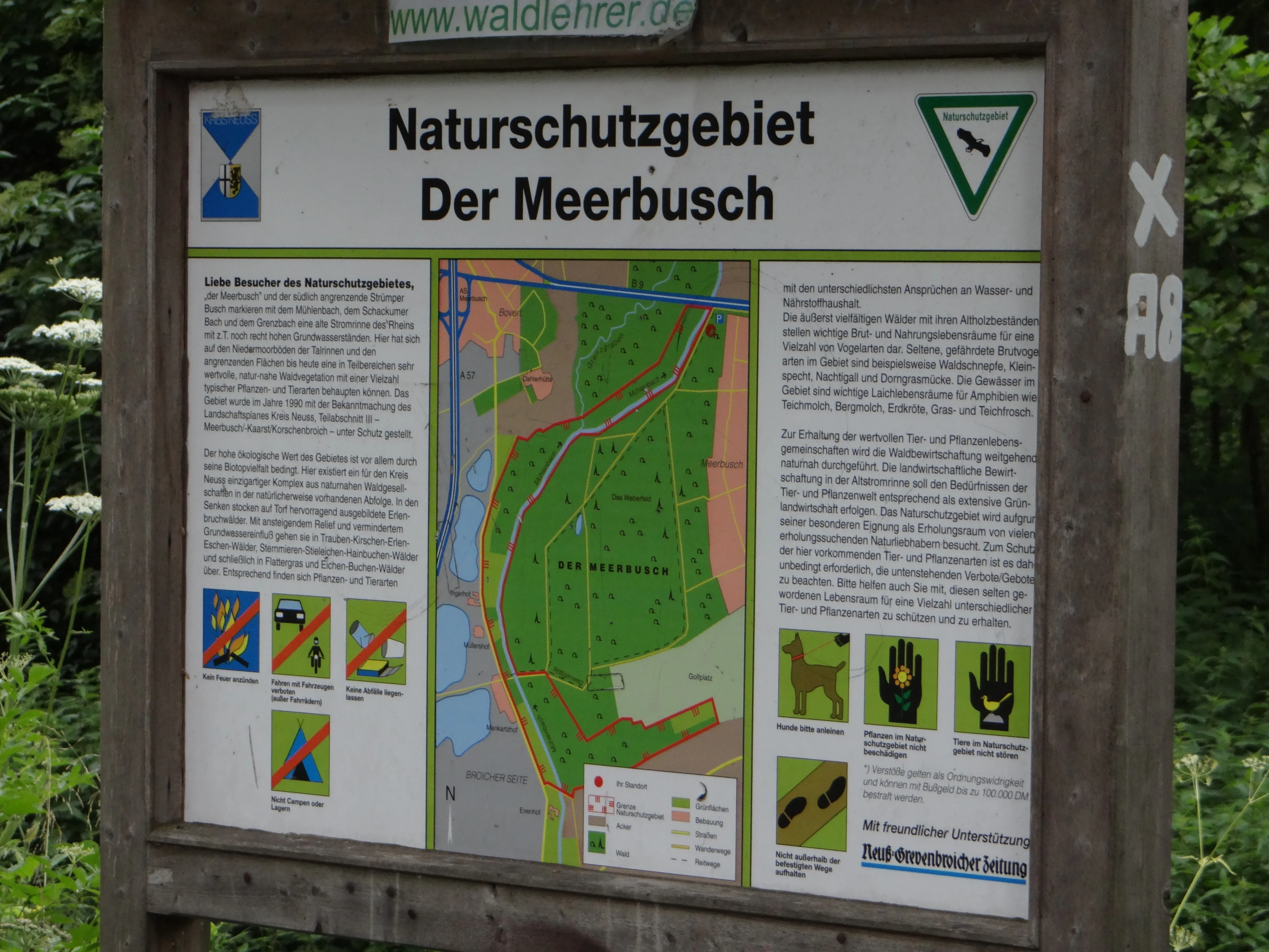
A wooden-framed information sign for the Der Meerbusch nature reserve, displaying a map and conservation rules.
Information sign for the Der Meerbusch nature reserve in North Rhine-Westphalia, Germany.

Der Meerbusch history and protected-area timeline

The name Meerbusch, also rendered Meerer Busch or Meererbusch, derives from the historic estate of Haus Meer, a former noble seat and monastery to the east of the forest, whose lands historically included the woodland. The estate name itself comes from the Lower Rhine dialect word Meer, meaning a wetland or pool, a fitting description of the waterlogged land around the old estate.

The forest was for centuries part of the agricultural and forestry domain of Haus Meer, and it is from this association that the garden city settlement of Alt-Meererbusch took its name, followed ultimately by the modern city of Meerbusch when it was founded in 1970 through the merger of several existing communities. Thus both the city and its most prominent green lung share a common etymological root.

In terms of formal protection, the ecologically valuable wetland core of the Meerbusch was designated a nature reserve in 1987, and the larger surrounding forest was incorporated into a landscape protection area in 1990 as part of the Strümper Busch, Meerbusch, Stinkesbachaue complex. The reserve is registered in the German federal NSG catalogue as NE-008 and in the World Database on Protected Areas under ID 162727.

Der Meerbusch landscape and geographic character

Der Meerbusch lies in the flat Rhine marshland on the left bank of the Rhine, in a region shaped by the slow migration of the river across geological time. The reserve sits on the trace of a former Rhine channel, an oxbow-like feature called a Kendel in local usage, that silted up as the active river course changed. The lingering high groundwater table along this old channel is responsible for the wetter soils and water features that distinguish the site from the surrounding agricultural and suburban land.

The terrain itself is almost level, reflecting its position in the Lower Rhine lowland, but the relief and texture of the forest are strongly influenced by water. The Meerscher Mühlenbach, once used to drive a mill at Haus Meer, runs through the area from south to north, joined at the forest's southern edge by the Schackumer Bach and by a dry ditch called the Grenzgraben flowing in from the northwest. Scattered standing water bodies and reed-lined pools punctuate the western fringe. Outside the wet core, the landscape changes character: toward the east the forest becomes higher and drier, dominated by beech and oak stands under forestry management, and the wider surroundings include gravel pits with artificial lakes crossed by the A57 autobahn, agricultural fields, and suburban neighborhoods.

Der Meerbusch ecosystems, habitats, and plant life

The nature of Der Meerbusch is best understood as a small-scale mosaic of habitats layered on top of one another, each reflecting the gradient from permanently waterlogged floodplain soils to drier upland-like woodland. The wet southern and western margins support an intact alder swamp woodland, in which black alder is the dominant tree and the ground layer is rich in mosses, sedges, and reed species. The presence of open pools and reedbeds within this forest gives it an almost boglike feel in places, despite lying only meters above sea level on a flat plain.

Eastward, the forest transitions into a mixed broadleaf community of willow, poplar, and ash, with a varied understory of shrubs and herbs. Here the canopy is more open and the soils progressively drier, supporting a different community of woodland plants. Some small, extensively managed meadows and field margins are included within the protected area, providing transitional habitats at the forest edge. Beyond the formally protected boundary, the forest is dominated by beech and pedunculate oak, indicating the more typical managed forest past of the area.

This ecological layering is what allows the reserve to play a meaningful role in protecting biodiversity in a region where intact floodplain forest has been heavily reduced by agriculture, gravel extraction, and urbanization.

Der Meerbusch wildlife and species highlights

The wet habitats at the core of Der Meerbusch provide refuge for fauna typical of the Lower Rhine floodplain forests, especially moisture-dependent groups. The alder swamp woodland, sedge communities, and small open waters form a habitat complex that supports breeding populations of various amphibians, including frogs and toads that depend on standing water for their larval stages. The same water bodies and dense thickets are used by a range of waterbirds and wetland-associated bird species, some of which are considered rare in the regional context.

The transitional mixed broadleaf woodland further east offers additional niches for woodland birds, small mammals, and insects tied to older broadleaf trees and varied undergrowth. Even the dry, managed beech-oak stands on the eastern edge contribute to local biodiversity by sustaining deadwood-dependent invertebrates and the bird communities of mature deciduous forest.

Der Meerbusch conservation status and protection priorities

Der Meerbusch is a small but disproportionately important conservation site because it preserves habitats, especially alder carr and associated wetland communities, that have become very rare in the densely populated and intensively used Lower Rhine floodplain. Its designation as a nature reserve in 1987 reflects recognition of the fragility of these wetland communities and of their significance for regional biodiversity.

The reserve is classified at the international level under IUCN Category IV, Habitat or Species Management Area, which signals that the primary management goal is to maintain specific habitats and the species they support, rather than to exclude human activity entirely. The site is recorded in the World Database on Protected Areas as ID 162727.

Since 1990 the site has also sat within the much larger Strümper Busch, Meerbusch, Stinkesbachaue landscape protection area, which highlights the geological importance of the old Rhine channel for the wider region. Threaded through this administrative patchwork is the broader conservation logic: protect the wettest, most ecologically valuable core as a strict nature reserve, while keeping the larger forested whole within a softer landscape protection regime that still protects continuity, hydrology, and habitat connectivity.

Der Meerbusch cultural meaning and human context

Although Der Meerbusch is principally valued for its natural character, the forest is tightly bound up with the cultural history of the surrounding area. For centuries the woodland belonged to the estate of Haus Meer, a former noble seat and later monastic site to the east of the forest, and the very name Meerbusch reflects this long association. The Lower Rhine dialect word from which Haus Meer takes its name referred to the wet meadows and pools of the surrounding land, a feature still visible today in the wetland core of the reserve.

The forest also lives on in the names of surrounding human settlements. The garden city of Alt-Meererbusch, founded just west of the woodland in the early twentieth century, carries the forest's name, and the modern city of Meerbusch itself, created through administrative reform in 1970, was named after the same historic Meer estate. Today the reserve provides a green, ecologically meaningful backdrop to a community that is otherwise defined by its position in the Rhine-Ruhr metropolitan region.

Top sights and standout views in Der Meerbusch

Key highlights of Der Meerbusch include its intact alder swamp woodland along the Meerscher Mühlenbach, its mosaic of small open water bodies, sedge beds, and reed stands, and the layered transition from wet floodplain forest to drier beech-oak woodland in the eastern part of the forest. The site stands out as one of the relatively few surviving examples of native Lower Rhine floodplain forest habitat in a region that has otherwise been heavily urbanized and converted to farmland or gravel pits.

Equally notable is the forest's integration into the larger Strümper Busch, Meerbusch, Stinkesbachaue landscape protection area, which secures a wider buffer around the strict nature reserve and emphasizes the old Rhine channel as a regionally important geological and ecological feature. The reserve's compact size belies its ecological significance and the long cultural memory preserved in its name.

Best time to visit Der Meerbusch

Der Meerbusch can be visited at any time of year, but the seasonal character of the site is shaped strongly by its wetland core. Spring is generally the most rewarding season for wildlife: rising water levels, the growth of sedges and reeds, and the activity of amphibians make the wet margins especially lively, and woodland bird song fills the older broadleaf stands. Early mornings in spring and early summer are typically the best time for observation of birdlife and other wetland fauna.

Autumn brings color to the broadleaf canopy of the eastern, drier parts of the forest and a quieter atmosphere in the wet core, while winter, when the alder and ash are bare, allows easier walking and clearer views into the swamp woodland structure and the open water features along the Meerscher Mühlenbach. In summer, mosquitoes and tall herb growth can make the wetter parts of the reserve less comfortable to explore, though the forest remains accessible throughout the year.

Monthly climate preview

Long term temperature and precipitation records measured at representative park coordinates

Der Meerbusch Climate Normals and Annual Weather Patterns

Historical climate data for Der Meerbusch records an annual temperature progression from winter minimums below freezing to summer maximums exceeding thirty degrees alongside steady daily precipitation. Examining the complete twelve month profile reveals detailed long term averages across every recorded interval at the reference elevation.
Annual mean10 °C
1 °C19 °C
Jan
Feb
Mar
Apr
May13°
Jun16°
Jul19°
Aug18°
Sep15°
Oct10°
Nov
Dec
Warmest month
July

18.6 °C

Coolest month
January

1.5 °C

Wettest month
December

2.8 mm/day

Driest month
April

1.6 mm/day

Park location guide

Geography guide, regional context, and park location map for Der Meerbusch

Der Meerbusch park geography, regions, and map view in Germany

Understand where Der Meerbusch sits in Germany through a broader geographic reading of the surrounding landscape, nearby location context, and its mapped position within the national park landscape.

How Der Meerbusch fits into Germany

Germany is a federal republic in Western and Central Europe with a population of over 83 million across sixteen constituent states. It is Europe's largest economy by nominal GDP and a major global exporter and importer. The capital is Berlin, and the country borders Denmark, Poland, Czech Republic, Austria, Switzerland, France, Luxembourg, Belgium, and the Netherlands.

Wider geography shaping Der Meerbusch in Germany

Germany is located in Western and Central Europe, spanning 357,022 km². It borders Denmark to the north, Poland and the Czech Republic to the east, Austria and Switzerland to the south, and France, Luxembourg, Belgium, and the Netherlands to the west. The country has coastlines on the Baltic Sea and North Sea to the north, with the Alps located in the southern region.

Map view of Der Meerbusch

Use this park location map to pinpoint Der Meerbusch in Germany, understand its exact geographic position, and read its mapped placement within the surrounding landscape more clearly.

Pigeon | © OpenStreetMap contributors

Location context for Der Meerbusch

Nordrhein-Westfalen

Explore photographic records of ancient alder swamp woodland, waterlogged terrain, and protected floodplain habitats.

Der Meerbusch Photos and Landscape Scenery: Visualizing the Protected Lower Rhine Wetland

Visual documentation of Der Meerbusch reveals the complex terrain of a silted-up former Rhine channel and its intact alder carr habitats. Examining these protected-area photographs helps observers understand the rare ecological character of this wetland environment within the Lower Rhine landscape.

A wooden-framed information sign for the Der Meerbusch nature reserve, displaying a map and conservation rules.

A calm, narrow stream winds through a dense green forest, with lush foliage and tall grasses lining the banks.

Park atlas

Compare adjacent wetland reserves and regional floodplain forest habitats in the Lower Rhine

Exploring Parks Near Der Meerbusch and Surrounding Protected Landscapes

Browse nearby national parks and protected areas to compare wetland reserves and riverine forest fragments across the surrounding region. Continuing outward from Der Meerbusch reveals the broader ecological spread of surviving lowland woodland habitats along the Rhine valley.
Watercolor painting of a green wetland landscape with a small body of water and soft rolling hills in the background.
Nature reserveNordrhein-Westfalen
About 2.1 km away#1 closest

Northeast

Ilvericher Altrheinschlinge Nature Reserve: Mapped Protected Landscapes in Nordrhein-Westfalen

Tracing the ancient oxbow meander of the Lower Rhine

Investigate the unique physical geography of the Ilvericher Altrheinschlinge, where ancient river dynamics create a preserved loop of floodplain forest and wet grassland. This nature reserve provides essential habitat connectivity in Nordrhein-Westfalen, offering a clear look at how human infrastructure and natural wetland systems intersect along the modern Rhine valley.

Area
3.081 km²
Established
1981
IUCN
IV
Relief
Lowland
A soft watercolor painting of a winding stream through a grassy meadow with gentle hills in the background.
Nature reserveNordrhein-Westfalen
About 6.7 km away#2 closest

North

Latumer Bruch Nature Reserve and Protected Wetland Geography in Nordrhein-Westfalen

A mapped overview of floodplain forests and Rhine channel landscapes

Latumer Bruch protects a unique lowland mosaic of alder swamp forest and dry grassland ridges near Krefeld. This nature reserve functions as a vital wetland refuge and floodwater retention basin, offering deep insight into the complex hydrologic character and ecological connectivity of the Lower Rhine region.

Area
1.85 km²
Established
1982
IUCN
IV
Relief
Lowland
A soft watercolor illustration depicting a winding river flowing through green meadows and forest clusters against a light sky background.
Nature reserveNorth Rhine-Westphalia
About 9.4 km away#3 closest

Northeast

Spey Nature Reserve: Protected Floodplain Geography and River Corridor in North Rhine-Westphalia

A detailed map of Rhine riverbank habitats and floodplain terrain

Spey Nature Reserve protects a characteristic slice of the Lower Rhine floodplain, featuring a layered landscape of softwood forest, river valley grasslands, and open shoreline. Situated within the Deichvorland between the cities of Krefeld and Meerbusch, this protected area serves as an essential ecological stepping stone and bird habitat. The reserve provides a valuable example of natural river processes preserved within the densely populated North Rhine-Westphalia region.

Area
1.06 km²
Established
1987
IUCN
IV
Relief
Lowland
Nature reserveKrefeld
About 13 km away#4 closest

Northwest

Hülser Bruch Nature Reserve: Geographic Atlas and Protected Landscape Mapping for Krefeld

A historic glacial plain and protected wetland habitat in the Lower Rhine region.

Hülser Bruch represents a vital protected area in Krefeld, characterized by clay rich soils, high groundwater levels, and ancient brook channels. The reserve preserves a distinct mosaic of coppice woodland and earthen embankments that reveal the geomorphological influence of Pleistocene ice sheets on this lowland territory.

Area
4.3 km²
Established
2002
Relief
Lowland
Climate
Temperate
Watercolor painting of a calm pond with cattails in the foreground and rolling hills in the background.
Nature reserveNorth Rhine-Westphalia
About 15 km away#5 closest

East

Naturschutzgebiet Pillebachtal, Dernkamp und Gallberg: Protected Landscape and Geography

Nature reserve in North Rhine-Westphalia, Germany

An urban-adjacent nature reserve, this area provides a mapped look at the transition between mature beech forest stands and moist wetland corridors along the Pillebach stream. It serves as a study in ecological structure, featuring reed beds, meadow springs, and gallery woodlands that offer a protected refuge within the Rhine-Ruhr metropolitan region.

Area
0.745 km²
Established
1996
IUCN
IV
Watercolor painting of a green valley with a winding stream and gentle hills in the background.
Nature reserveNordrhein-Westfalen
About 17 km away#6 closest

East

Morper Bachtal: Mapped Nature Reserve and Stream Valley Geography in Germany

Protected wetland landscapes and regional habitat connectivity.

Morper Bachtal represents a tightly layered protected area where open water, reedbeds, and beech forests converge along the Rotthäuser Bach. This detailed look at its landscape composition and position within the district of Mettmann reveals the significance of its compact, undulating terrain and corridor role in German regional geography.

Area
0.74 km²
Established
1984
IUCN
IV
Relief
Upland
A soft, light watercolor painting of a green, rolling valley with trees and gentle hills, rendered in a minimalist style on a white background.
Nature reserveNordrhein-Westfalen
About 18 km away#7 closest

East

Hubbelrather Bachtal: Nature Reserve and Protected Stream Valley in Nordrhein-Westfalen

A diverse habitat mosaic from lowland wetlands to dry sandy slopes

Hubbelrather Bachtal is a protected nature reserve in the Mettmann district, defined by a basin-shaped valley floor along the Hubbelrather Bach. The area features a complex mosaic of reedbeds, sedge-rich grasslands, and beech woodland slopes, providing essential refuge for endangered species in the urbanized corridor between Düsseldorf and the Bergisches Land.

Area
28.29 km²
Established
1997
IUCN
IV
A horizontal watercolor illustration of a calm stream flowing through a wetland with green trees and grasses along the banks.
Nature reserveNordrhein-Westfalen
About 18 km away#8 closest

Northeast

Hummelsbach Nature Reserve: Mapped Protected Brook and Floodplain Landscape in Nordrhein-Westfalen

Protected sandy stream and alder woodland mosaic

Located in the Mettmann district of Nordrhein-Westfalen, Hummelsbach preserves a near-natural sandy brook and alder floodplain forest. This reserve functions as an essential ecological bridge between rolling hill forests and lowland floodplains, providing a concentrated look at specialized habitats within a mosaic of meadows and wet woodland.

Area
0.13 km²
Established
1984
IUCN
IV

Common questions about visiting, size, designation, and location context for Der Meerbusch

Der Meerbusch FAQs for park facts, access, geography, and protected area context

Find quick answers about Der Meerbusch, including protected-area facts, park geography, trail and visitor context, and how the park fits into its surrounding country and regional landscape.
MoriAtlas Explorer

Continue Your Protected Areas Search Across the Global Atlas

Deepen your exploration by continuing the structured search for national parks and protected areas worldwide. Utilize the comprehensive filtering capabilities to compare different conservation landscapes and refine your understanding of global park geography. Discover more about the distribution and characteristics of protected natural areas.

Global natural geography