
Mori Atlas logo
Nature reserveEnkheimer Ried

Analyzing the ecological boundaries and terrain of this urban-adjacent nature reserve

Enkheimer Ried Nature Reserve: Mapping the Protected Wetland Landscapes of Hesse, Germany

(Naturschutzgebiet Enkheimer Ried)

Enkheimer Ried represents a vital protected landscape within the Frankfurter Grüngürtel, defined by its complex wetland habitat and historical oxbow geography. This atlas entry provides a detailed look at the nature reserve, covering its situation along the Tränkebach stream and its significant role as a managed refuge for wetland biodiversity near Frankfurt.

wetlandnature reserveurban naturepondreed bedorchids
A digital illustration of a serene pond surrounded by a forest and reeds at sunset.

Enkheimer Ried

Nature reserve

Park overview

Structured park overview, official facts, and landscape profile for Enkheimer Ried

Enkheimer Ried park facts, protected area profile, and essential visitor context

Review the core facts for Enkheimer Ried, including designation, size, terrain, visitor scale, habitats, and operating context in one park-focused overview.

About Enkheimer Ried

Enkheimer Ried occupies a special place among German nature reserves because it combines a compact, ecologically dense wetland system with a striking urban setting. Located on the boundary between the Frankfurt district of Bergen-Enkheim and the neighboring municipality of Maintal, the reserve sits along the Tränkebach stream, known locally as the Riedgraben, and is dominated by the Riedteich pond that gives the area much of its character.

The pond is not a natural lake in its current form but the descendant of a long-evolving landscape. Geologically, it sits on a Pleistocene terrace in the ancient glacial valley of the Main and Kinzig rivers, and the body of water represents a partially silted-up former oxbow. The trace of an older Main channel can still be reconstructed across the broader region, passing through nearby Enkheim and Seckbach toward Frankfurt's eastern Ostpark.

Before the 19th century, when the Main was canalized, the entire Enkheimer Ried area was a swamp that regularly flooded. Centuries of human intervention, including medieval drainage attempts, peat cutting from 1829 to 1864, ice harvesting until 1924, post-war infilling of part of the pond for sports facilities, and aggressive reed clearance in the 1950s and 1960s, heavily altered the site. Since the 1970s, progressive legal protection and small-scale renaturation efforts have shifted the trajectory toward ecological recovery.

Today, Enkheimer Ried stands out as a refuge within the Rhine-Main urban region. Its mosaic of reed beds, wet meadows, sedge communities, alder and willow woodland, and open water supports rare orchid populations, breeding and migratory waterbirds, amphibians, fish, and one of Germany's last known reproducing populations of the European pond turtle. The reserve is also part of the Frankfurter Grüngürtel, a ring of protected green spaces encircling the city.

Quick facts and research context for Enkheimer Ried

Enkheimer Ried is a designated nature reserve (Naturschutzgebiet) covering approximately 28 hectares on the eastern outskirts of Frankfurt am Main, in the state of Hesse. It was first protected in 1937 and significantly expanded over the following decades, with its current extent set in 1995 under the identifier 1412002.

The reserve's central feature is the Riedteich, a roughly 4.5-hectare former oxbow of the Main and Kinzig rivers. Enkheimer Ried sits within the Frankfurter Grüngürtel landscape protection area.

Protection and recognition

Documented terrestrial protection metrics and official designation timeline

Enkheimer Ried Protection Status and Designated Area History

Enkheimer Ried maintains a documented terrestrial protection status established in 1937, providing verified baseline data for conservation research. Official records track the protected area designation and management scope through standardized international registers.

Protection details

Protection scope
Terrestrial
Designated year
1937
Transboundary protection
No
WDPA ID
81609
Park context

Deeper park guide and search-rich context for Enkheimer Ried

Enkheimer Ried history, landscape, wildlife, and travel context

Explore Enkheimer Ried through its history, landscape character, ecosystems, wildlife, conservation priorities, cultural context, and seasonal travel timing in a structured park guide built for atlas discovery and search intent.

Why Enkheimer Ried stands out

Enkheimer Ried is best known for being a small but species-rich urban wetland enclave that supports rare and endangered flora and fauna, including threatened orchid species and the European pond turtle. Its location, just outside the dense city of Frankfurt, gives it particular significance as a refuge for wetland biodiversity in a heavily built-up region.
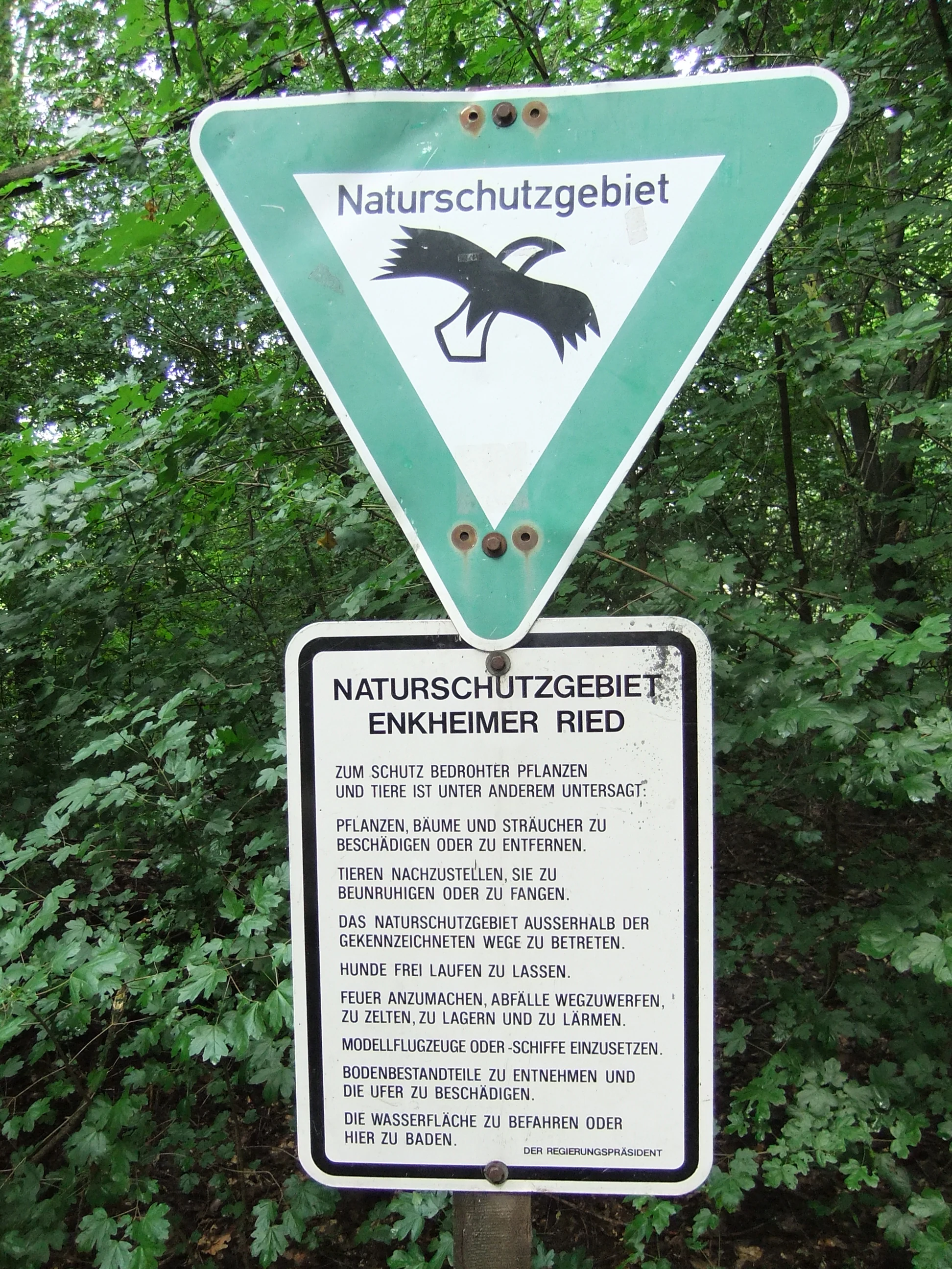
A triangular green and white nature reserve sign with a bird icon above a rectangular information sign listing prohibited activities in German, set against a background of green forest foliage.
A nature reserve sign at Enkheimer Ried outlining local conservation regulations.

Enkheimer Ried history and protected-area timeline

The history of Enkheimer Ried is closely entwined with human modification of the landscape around the Main and Kinzig rivers. Until 19th-century canalization of the Main, the area was a regularly flooded swamp on the Pleistocene terraces of the Main-Kinzig glacial valley. Early medieval drainage efforts, including a water channel extending from Bischofsheim through Enkheim and Seckbach toward Frankfurt's old Rechneigraben, are believed to have had limited effect.

Between 1829 and 1864, the municipality of Enkheim leased the land for peat cutting, transforming the wetland into a series of ponds up to five meters deep. These ponds were used for ice harvesting until 1924, with water levels deliberately manipulated to maximize winter ice yields. After World War II, the western portion of the pond system was infilled to create building ground for sports and leisure facilities that remain in use today.

Protection efforts began in the mid-1920s and advanced when the Allgemeiner Almosenkasten foundation acquired the land in 1936. The reserve was formally decreed in 1937 under the name NSG Enkheimer Riedteiche, covering around 8.63 hectares at that time. Expansion in 1973 brought the area to 15.44 hectares, and a further extension in 1995 (following applications submitted in 1984 and 1986) brought it to its current size of approximately 28.23 hectares. The site has been part of the Frankfurter Grüngürtel landscape protection area since 1991, and partial renaturation of the Tränkebach was carried out in 1997.

Enkheimer Ried landscape and geographic character

The landscape of Enkheimer Ried is shaped by the interplay between an ancient river terrace and an altered former oxbow system. The reserve lies in a Pleistocene Urstromtal setting, with the Riedteich pond dominating its center at roughly 4.5 hectares of open water. To the east, the floodplain of the Tränkebach, sometimes called the Riedgraben, extends the wetland habitat beyond the pond's edge.

To the south, the Enkheimer Wald borders the reserve, while to the north rises the Berger Hang slope, part of the broader Berger Rücken ridge system. The surrounding landscape mixes forested slopes, suburban development, roads, and the A 66 autobahn running about a kilometer to the south, emphasizing how closely Enkheimer Ried sits within the densely structured Rhine-Main urban environment.
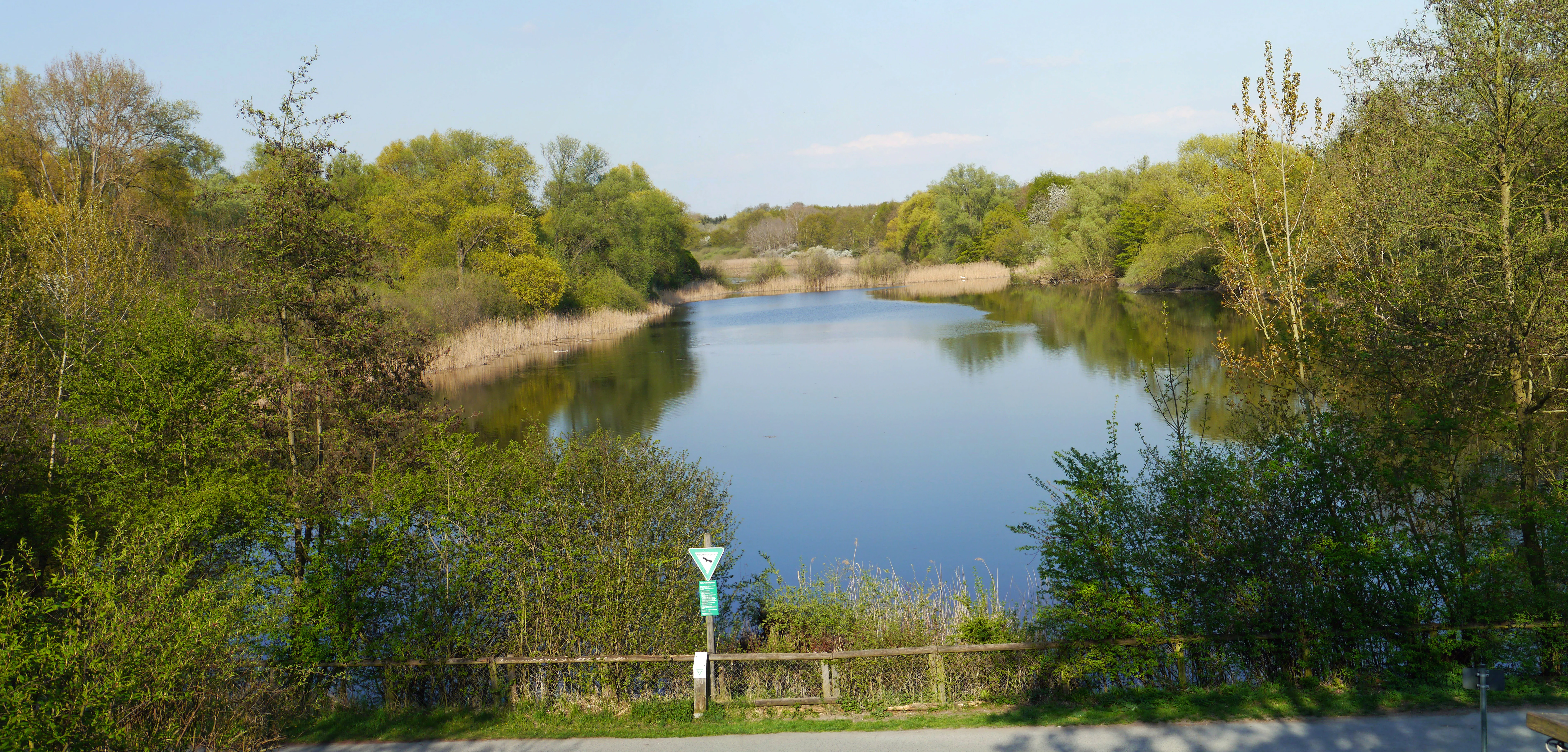
A calm, still pond surrounded by lush green trees and reeds, viewed from a slightly elevated position with a wooden fence and trail in the foreground.
The Riedteich pond at Enkheimer Ried, a nature reserve in Hesse, Germany.

Enkheimer Ried ecosystems, habitats, and plant life

Enkheimer Ried is ecologically defined by its concentrated wetland habitats within an urban context. The reserve's biotope complex centers on the Riedteich and the adjacent floodplain of the Tränkebach, supporting reed beds dominated by reed and watercress, shoreline alder and willow woodland, and a zone of wet meadows, sedge communities, and oat-grass meadows on the western side of the pond.

According to Hessian nature protection law, sections of the reserve qualify as particularly protected biotopes of swamp forest, riparian forest, and wet meadow character. The mosaic of habitats creates conditions for a wide range of specialized wetland plants and animals, giving Enkheimer Ried an unusually high biodiversity density relative to its small size.

Enkheimer Ried wildlife and species highlights

Enkheimer Ried supports a notably diverse fauna for so small an urban-adjacent reserve. Bird surveys in 1992 and 1999 by the Vogelkundliche Beobachtungsstation Untermain documented around 140 species overall, with several threatened waterbirds, including the Eurasian teal, northern shoveler, and northern pintail, considered at risk of extinction in the area. The reserve is recognized as a regionally significant bird breeding area.

The European pond turtle is one of the reserve's most important species. Studies in the 1990s found fewer than ten individuals remaining, a population considered the last known reproductively viable group in Germany. Fossil shell finds indicate the species has been present locally for about 5,000 years; special measures, including constructed egg-laying sites, have been taken to protect the survivors.

Amphibian surveys, originally recording eleven species in 1955, still confirm protected species such as the common frog, edible frog, and common toad in later decades. Fish inventories from 1987 and 1992 documented nine species in the Riedteich, including threatened taxa like pike, tench, and rudd. Mammal records include roe deer, European hare, European rabbit, common shrew, and common vole. Invertebrate groups surveyed include 105 beetle species, 17 butterfly species, 16 to 19 dragonfly species, 11 grasshopper species, around 80 spider species, and a historic 45 mollusk species noted in 1955.

Enkheimer Ried conservation status and protection priorities

Enkheimer Ried is a legally protected nature reserve under Hessian law, with its status codified under the identifier 1412002. Its conservation value lies in the concentration of rare and threatened wetland species within a small, urban-adjacent footprint, including orchids, waterbirds, amphibians, and a nationally important European pond turtle population.

Since 1991, the reserve has been embedded within the Frankfurter Grüngürtel, which strengthens its role as part of a continuous green ring around the city. Conservation work in the area has included partial renaturation of the straightened Tränkebach, wetland habitat retention in and around the Riedteich, and species-specific measures such as artificial egg-laying sites for the European pond turtle. The reserve's small scale, combined with the high biodiversity it sustains, gives it disproportionate regional and national ecological significance relative to its size.

Top sights and standout views in Enkheimer Ried

Enkheimer Ried's strongest features include the Riedteich, a former Main-Kinzig oxbow that has evolved over centuries into a refuge for rare wetland species. The reserve is notable for its population of threatened orchids, including the early marsh-orchid and broad-leaved marsh-orchid, and for hosting what is considered the last known reproducing population of the European pond turtle in Germany.

It also serves as an ecologically valuable anchor within the Frankfurter Grüngürtel, demonstrating how small wetland pockets near a major metropolis can sustain unusually high biodiversity when given long-term legal protection and careful habitat management.

Best time to visit Enkheimer Ried

Enkheimer Ried is best experienced during the warmer months, when the wetland vegetation is fully developed and waterbird activity is most visible. Spring and early summer bring active amphibian breeding behavior, while late summer and early autumn offer peak reed-bed habitat and migrating bird presence in the region. Visits during winter can offer a quieter, more open view of the pond's structure, though many paths are affected by dense vegetation that limits direct shoreline access throughout the year.

Monthly climate preview

Long-term temperature and precipitation records across twelve months

Enkheimer Ried Climate Normals and Measured Weather by Month

Enkheimer Ried exhibits a measured annual cycle spanning from freezing winter minimums to warm summer maximums alongside steady precipitation rates. Reviewing the comprehensive monthly climate records provides detailed context on long-term temperature swings and baseline moisture patterns.
Annual mean10 °C
0 °C21 °C
Jan
Feb
Mar
Apr10°
May14°
Jun18°
Jul21°
Aug20°
Sep15°
Oct10°
Nov
Dec
Warmest month
July

20.6 °C

Coolest month
January

0.2 °C

Wettest month
July

2.2 mm/day

Driest month
April

1.4 mm/day

Park location guide

Geography guide, regional context, and park location map for Enkheimer Ried

Enkheimer Ried park geography, regions, and map view in Germany

Understand where Enkheimer Ried sits in Germany through a broader geographic reading of the surrounding landscape, nearby location context, and its mapped position within the national park landscape.

How Enkheimer Ried fits into Germany

Germany is a federal republic in Western and Central Europe with a population of over 83 million across sixteen constituent states. It is Europe's largest economy by nominal GDP and a major global exporter and importer. The capital is Berlin, and the country borders Denmark, Poland, Czech Republic, Austria, Switzerland, France, Luxembourg, Belgium, and the Netherlands.

Wider geography shaping Enkheimer Ried in Germany

Germany is located in Western and Central Europe, spanning 357,022 km². It borders Denmark to the north, Poland and the Czech Republic to the east, Austria and Switzerland to the south, and France, Luxembourg, Belgium, and the Netherlands to the west. The country has coastlines on the Baltic Sea and North Sea to the north, with the Alps located in the southern region.

Map view of Enkheimer Ried

Use this park location map to pinpoint Enkheimer Ried in Germany, understand its exact geographic position, and read its mapped placement within the surrounding landscape more clearly.

Pigeon | © OpenStreetMap contributors

Location context for Enkheimer Ried

Hesse

Visual reference of rare habitats, oxbow ponds, and urban nature reserves

Enkheimer Ried Photos and Landscape Scenery: Protected Wetland Views

Visual documentation captures the complex wetland habitats, open water ponds, and riparian vegetation defining the Enkheimer Ried nature reserve. Examining detailed landscape photography reveals the unique ecological character of this protected urban refuge nestled against the Frankfurt metropolitan edge.

A triangular green and white nature reserve sign with a bird icon above a rectangular information sign listing prohibited activities in German, set against a background of green forest foliage.

A calm, reflective pond surrounded by lush green trees and reeds under a dark, overcast sky.

A calm, still pond surrounded by lush green trees and reeds, viewed from a slightly elevated position with a wooden fence and trail in the foreground.

Park atlas

Compare surrounding wetland reserves and protected landscapes across the region

Other Protected Areas and Parks Near Enkheimer Ried for Regional Exploration

Visitors exploring Enkheimer Ried can discover other nearby protected areas and regional wetland reserves to compare surrounding conservation landscapes. Expanding the geographic scope reveals connected habitats and urban green spaces within the broader regional park network.
A horizontal watercolor illustration showing soft, abstract layers of hills, valleys, and forest greenery in pastel tones of green, yellow, and muted pink against a white background.
Nature reserveHessen
About 2.2 km away#1 closest

West

Mühlbachtal von Bergen-Enkheim Nature Reserve: Geographic and Landscape Discovery

A protected valley refuge within the Hessen regional landscape

Mühlbachtal von Bergen-Enkheim is a nature reserve in Hessen, Germany, distinguished by its compact size and high botanical diversity. The valley, carved into the Berger Rücken ridge, maintains unique habitat types including wet meadows and traditional orchards. It provides a rare look at the floodplain forest relics that once defined the surrounding region, offering a clear study in urban-edge conservation geography.

Area
0.033 km²
Established
1986
IUCN
IV
A soft watercolor painting of a serene landscape featuring a central body of water surrounded by green banks, shrubs, and gentle rolling hills in the background.
Nature reserveHessen
About 8.2 km away#2 closest

Southeast

Oberwaldsee von Dietesheim Nature Reserve: Atlas and Geographic Landscape Overview

Protected basalt terrain in the Hessen region

Discover the geographic character of Oberwaldsee von Dietesheim, a protected nature reserve in Hessen defined by flooded basalt quarries and open sandy dry-grassland. This site serves as a vital ecological stepping stone within the Untermain lowlands, offering a study in microtopography and habitat diversity. Access detailed mapping and protected-area context for this essential German nature reserve within the Rhine-Main metropolitan corridor.

Area
0.335 km²
Established
1989
IUCN
IV
Nature reserveLandkreis Offenbach
About 8.2 km away#3 closest

Southeast

Mayengewann von Lämmerspiel: Nature Reserve and Protected Landscape in Landkreis Offenbach

Oak woodlands and rare orchid meadows within the Rhine-Main landscape

Examine the geography of Mayengewann von Lämmerspiel, a significant nature reserve characterized by its mosaic of old oak forest and moist grassland. This site acts as an ecological refuge in Landkreis Offenbach, safeguarding rare species such as the fen violet, adder's-tongue fern, and multiple orchid varieties within a carefully managed protected boundary.

Area
0.067 km²
Established
1985
IUCN
IV
Relief
Lowland
Watercolor illustration of a soft rolling landscape with grassy fields, scattered trees, and rolling hills in shades of green and yellow.
Nature reserveHessen
About 8.8 km away#4 closest

Southeast

Amerikafeld und Schindkaute bei Steinheim: Nature Reserve and Protected Grassland Map

Rare sand dry grassland habitat within the Hessen metropolitan region.

Amerikafeld und Schindkaute bei Steinheim is a protected nature reserve in Hanau that shelters scarce sand dry grasslands. The terrain, defined by ice-age sandy deposits, remains an important ecological island, maintaining an open steppe-like character through historic grazing practices in a landscape otherwise dominated by urban growth.

Area
16 km²
Established
1995
Watercolor painting of a green wetland landscape with trees, grasses, and distant rolling hills on a white background.
Nature reserveHessen
About 9.7 km away#5 closest

South

Erlensteg von Bieber Nature Reserve: Geographic Map and Protected Habitat Overview

Compact wetland and forest mosaic in the Hessen region

Erlensteg von Bieber preserves a rare concentration of habitat types within a small footprint. From its moist floodplain meadows and sedge wetlands to its drier forest glades and fallow fields, this reserve showcases vital conservation management in the Rhine-Main area of Germany.

Area
0.752 km²
Established
1996
IUCN
IV
A soft, horizontal watercolor painting depicting green rolling hills and wetland vegetation.
Nature reserveHessen
About 9.9 km away#6 closest

West

Riedwiesen Nature Reserve: Mapped Protected Wet Meadow Landscapes in Hessen, Germany

A critical fragment of floodplain ecology within the Frankfurt Grüngürtel

Riedwiesen serves as a protected nature reserve, preserving 20 hectares of wet meadow habitat along the Nidda river. This site highlights the intersection of urban infrastructure and resilient floodplain geography, providing a refuge for characteristic amphibians and wetland vegetation within the Hessen landscape.

Area
0.205 km²
Established
1983
IUCN
IV
A horizontal watercolor painting showing a stylized, layered forest scene in muted green, pink, and yellow tones on a white background.
Nature reserveHesse
About 11 km away#7 closest

Southeast

Lauternsee bei Klein-Auheim Nature Reserve: Geography and Protected Bog Landscape

A historic high terrace habitat within the Hesse woodland region.

Lauternsee bei Klein-Auheim represents a specialized Flachmoor habitat that emerged from a former river channel of the Main. This nature reserve serves as an important ecological anchor in the lower Main valley, protecting essential wetlands, amphibian populations, and unique marsh plant communities within an expansive forest setting.

Established
1987
Nature reserveHessen
About 11 km away#8 closest

South

Bruch von Gravenbruch Nature Reserve: Geographic Profile and Protected Wetland Mapping

Hessen lowland moor and wetland habitat analysis

Examine the detailed terrain of Bruch von Gravenbruch, a notable nature reserve in Hessen characterized by its high groundwater table and intricate moisture-dependent ecosystems. The area serves as a key reference for studying lowland moor development, bog woodland structure, and the spatial distribution of protected wetland meadows across the regional landscape.

Area
0.932 km²
Established
1984
IUCN
IV

Common questions about visiting, size, designation, and location context for Enkheimer Ried

Enkheimer Ried FAQs for park facts, access, geography, and protected area context

Find quick answers about Enkheimer Ried, including protected-area facts, park geography, trail and visitor context, and how the park fits into its surrounding country and regional landscape.
MoriAtlas Explorer

Continue Your Protected Areas Search Across the Global Atlas

Deepen your exploration by continuing the structured search for national parks and protected areas worldwide. Utilize the comprehensive filtering capabilities to compare different conservation landscapes and refine your understanding of global park geography. Discover more about the distribution and characteristics of protected natural areas.

Global natural geography