Mori Atlas logo
Protected areaEthniko Dasiko Parko Potamos Liopetriou

A concentrated mosaic of Mediterranean habitats, coastal wetlands, and juniper shrubland ecosystems.

Ethniko Dasiko Parko Potamos Liopetriou: Mapped Coastal Protected Area in Southeastern Cyprus

Ethniko Dasiko Parko Potamos Liopetriou serves as a critical protected landscape at the confluence of the Liopetri River and the southeastern coast of Cyprus. This compact area preserves six distinct Mediterranean habitat types, ranging from seasonal wetlands and embryonic dunes to rugged cliffs and juniper matorral. By providing a stable refuge for diverse bird, bat, and reptile populations, the site acts as an ecological anchor within a heavily human-influenced coastal geography.

coastal wetlandsMediterranean habitatstemporary pondscoastal dunesphryganajuniper matorral

Ethniko Dasiko Parko Potamos Liopetriou

Protected area

Park overview

Structured park overview, official facts, and landscape profile for Ethniko Dasiko Parko Potamos Liopetriou

Ethniko Dasiko Parko Potamos Liopetriou park facts, protected area profile, and essential visitor context

Review the core facts for Ethniko Dasiko Parko Potamos Liopetriou, including designation, size, terrain, visitor scale, habitats, and operating context in one park-focused overview.

About Ethniko Dasiko Parko Potamos Liopetriou

Ethniko Dasiko Parko Potamos Liopetriou is a Natura 2000 site in southeastern Cyprus that conserves a representative slice of Mediterranean coastal nature at the mouth of the Liopetri River. Although modest in extent at under 75 hectares, the site's significance lies in the unusual variety of habitats it brings together in a single continuous landscape. Riverine margins, saline-influenced flats, beaches, dunes, low cliffs, and upland scrub transition into one another across a short distance, creating the kind of ecological complexity that is increasingly rare on a heavily developed Mediterranean coastline.

The area matters most for the wildlife that depends on this transition zone, especially birds that use coastal wetlands, seasonal pools, and open low scrub for feeding and breeding. Migratory paths along the eastern Mediterranean pass directly through Cyprus, and the Liopetri River mouth forms one of the small but reliable stepping stones along that route. The site's triple designation as a bird protection area, a Site of Community Importance, and a Special Area of Conservation underlines how many different ecological functions it serves at once.

Beyond its formal designations, the site offers an instructive example of how Mediterranean coastal ecosystems function as integrated wholes. The temporary ponds that fill after winter rains link the river system to the dunes; the dune vegetation stabilizes the coastal edge; and the phrygana and juniper shrubland on slightly higher ground extend habitat continuity inland. Each element reinforces the others, and the loss of any one of them would diminish the value of the rest.

Quick facts and research context for Ethniko Dasiko Parko Potamos Liopetriou

Ethniko Dasiko Parko Potamos Liopetriou is located in Cyprus and falls under the country's Natura 2000 network with the site code CY3000001. The site's center sits at approximately 34.969°N, 33.894°E, placing it in the southeastern part of the island near the Liopetri River mouth.

The protected area covers 74.74 hectares entirely on land. It has been designated as a Special Protection Area for birds, a Site of Community Importance, and a Special Area of Conservation, accumulating protections between 2009 and 2021. It lies within the Mediterranean ecoregion and is recognized for both its habitats and the presence of protected plant, bird, and mammal species.

Protection and recognition

Documented terrestrial protection scope, designation year, and international recognition records

Ethniko Dasiko Parko Potamos Liopetriou Protection Status and Designation History

Ethniko Dasiko Parko Potamos Liopetriou maintains a documented terrestrial protection scope established in the year 2009. Official records outline the formal designation history and international recognition sources associated with the protected area.

Protection details

Protection scope
Terrestrial
Designated year
2009
Transboundary protection
No
Park context

Deeper park guide and search-rich context for Ethniko Dasiko Parko Potamos Liopetriou

Ethniko Dasiko Parko Potamos Liopetriou history, landscape, wildlife, and travel context

Explore Ethniko Dasiko Parko Potamos Liopetriou through its history, landscape character, ecosystems, wildlife, conservation priorities, cultural context, and seasonal travel timing in a structured park guide built for atlas discovery and search intent.

Why Ethniko Dasiko Parko Potamos Liopetriou stands out

The protected area is best known for the concentration of bird species it shelters within a very small coastal footprint. The mix of seasonal pools, low coastal dunes, sea-cliff vegetation, and juniper phrygana creates a layered environment that supports breeding, wintering, and migratory birds along the southeastern Cypriot coast. Equally distinctive is the habitat diversity packed into the site, with no fewer than six natural Mediterranean habitat types present, including rare formations such as temporary Mediterranean ponds and Mediterranean cliff vegetation with endemic Limonium species. The combination of these habitats within a single compact area gives the site disproportionate ecological value relative to its size.

Ethniko Dasiko Parko Potamos Liopetriou history and protected-area timeline

The protected area's modern identity is shaped by Cyprus's participation in the Natura 2000 network, the European Union's framework for conserving natural habitats and wild species. The site was first formally recognized in December 2009, when it was designated as a Special Protection Area to safeguard its avifauna. From that initial recognition, the site's conservation profile expanded over more than a decade.

In February 2016, the area was additionally listed as a Site of Community Importance, broadening the range of habitats and species considered in its protection. The final step came in July 2021, when the area was confirmed as a Special Area of Conservation. This progression, from bird-focused designation toward a fuller habitat- and species-based protection regime, reflects how the site's natural value came to be appreciated in increasingly comprehensive terms.

Ethniko Dasiko Parko Potamos Liopetriou landscape and geographic character

The landscape of Ethniko Dasiko Parko Potamos Liopetriou is defined by the meeting point of the Liopetri River with the southeastern Cypriot coast. The terrain is low and gently undulating, shaped by the slow accumulation of coastal sediments along the river mouth and the gradual rise inland toward phrygana-covered slopes. There are no dramatic landforms; instead, the site's character is built from subtle transitions between riverbank, marshy flats, beach, dune, low cliff, and shrubland.

This layered coastal geography is the visual signature of the area. Salt-influenced soils near the coast give way to looser sandy substrates along the embryonic dune belt, which in turn backs onto more stable dune and scrub formations. Slightly inland, the juniper-dominated matorral and Sarcopoterium spinosum phrygana introduce a denser, rougher Mediterranean character. The result is a landscape where the eye reads multiple ecological zones within a short walk, an unusual trait in a coastal protected area of this size.

Ethniko Dasiko Parko Potamos Liopetriou ecosystems, habitats, and plant life

Ecologically, the site sits firmly within the Mediterranean ecoregion, and its natural value lies in the intersection of marine, freshwater, and terrestrial influences in a single compact area. Six natural habitat types have been identified, including annual vegetation at the tidal limit, Mediterranean sea cliffs with endemic Limonium species, mobile dunes with embryonic vegetation, Mediterranean temporary ponds, juniper-dominated arborescent matorral, and Sarcopoterium spinosum phryganas.

Each of these habitats plays a distinct ecological role. Temporary Mediterranean ponds fill after seasonal rains, hosting specialized plants and invertebrates before drying out. Coastal cliffs with endemic Limonium vegetation preserve botanically rare plant communities adapted to salty, wind-exposed conditions. Mobile dunes with embryonic vegetation represent an early stage of coastal dune succession and are particularly sensitive to disturbance. Further inland, the juniper matorral and phrygana provide structural variety and refuge for reptiles, insects, and birds, rounding out a habitat mosaic that mirrors the broader southeastern coastal character of Cyprus.

Ethniko Dasiko Parko Potamos Liopetriou wildlife and species highlights

The wildlife profile of the site is heavily shaped by birds, with eighteen protected bird species forming part of its core conservation justification. The bird community combines resident Mediterranean species with migratory and wintering visitors. Among the notable species are the European kingfisher, the purple heron, and the little egret, which use the river and pond habitats; the stone curlew and the Kentish plover, which favor drier open ground and coastal flats; and the collared flycatcher and the masked shrike, more typical of scrubby and lightly wooded areas.

Raptors and larks also appear in the recorded list, including the short-toed lark, the wood lark, and Cyprus-specific endemics or near-endemics, illustrating how the site overlaps with ranges that are restricted to the island or its immediate region. Beyond birds, six bat species are protected within the area, including the long-winged bat, Geoffroy's bat, and three horseshoe bat species. Reptile and amphibian diversity is also notable, with sixteen reptile species and three amphibian species recorded, alongside sixteen additional plant species that complement the protected Crepis pusilla population.

Ethniko Dasiko Parko Potamos Liopetriou conservation status and protection priorities

The site's conservation significance is widely recognized at the European level through its triple Natura 2000 designation, a relatively rare status that signals broad agreement on its ecological value. As a Special Protection Area, a Site of Community Importance, and a Special Area of Conservation, it benefits from overlapping legal protections targeting habitats, birds, bats, and other protected fauna and flora.

From a conservation standpoint, the area serves as a refuge for habitats that have become scarce along developed Mediterranean coasts, especially temporary ponds, embryonic dunes, and cliff vegetation with endemic Limonium species. These habitats are vulnerable to trampling, coastal infrastructure, water abstraction, and invasive species, all of which are pressures common in southeastern Cyprus. Maintaining the mosaic in a functional condition is therefore a key conservation priority, not only for its intrinsic value but also because the site contributes to wider regional networks of coastal and wetland habitats that migratory species depend on.

Top sights and standout views in Ethniko Dasiko Parko Potamos Liopetriou

Ethniko Dasiko Parko Potamos Liopetriou combines six distinct Mediterranean habitats within a small footprint, making it unusually rich for a coastal site. The seasonal ponds, embryonic dunes, and juniper matorral are particularly noteworthy, each representing a habitat type that has become rare along Cyprus's developed coast.

The site also stands out for the breadth of its protected fauna, from eighteen bird species to six bat species and a diverse reptile community. Its triple Natura 2000 designation, including Special Protection Area, Site of Community Importance, and Special Area of Conservation status, underlines how many layers of value this modest coastal area carries at once.

Best time to visit Ethniko Dasiko Parko Potamos Liopetriou

The site reflects strong Mediterranean seasonality, with the temporary ponds and lush coastal vegetation most visible in late winter and spring, when seasonal rains recharge the wetland systems and migratory birds are most active. Spring also brings flowering of coastal plants and more stable conditions for observing reptiles and breeding birds.

Summer shifts the character of the area toward drier conditions, with phrygana and juniper stands dominating the scene and many wetland-dependent birds moving on. Autumn and early winter mark the return of migrants and the gradual refilling of the temporary ponds. Each season underlines a different facet of the site: the wetland pulse in cooler months and the dry Mediterranean shrubland community that takes over during the long Cypriot summer.
Monthly climate preview

Long term monthly temperature averages and precipitation records sampled at a representative coordinate

Annual Climate Normals and Temperature Patterns for Ethniko Dasiko Parko Potamos Liopetriou

Historical data from 1991 to 2020 documents the measured annual temperature progression and monthly precipitation rates recorded at a representative coordinate within Ethniko Dasiko Parko Potamos Liopetriou. Examining the full twelve month sequence provides deeper insight into long term weather by month and continuous baseline climate normals across the protected area.
Annual mean21 °C
14 °C30 °C
Jan14°
Feb14°
Mar15°
Apr18°
May23°
Jun27°
Jul30°
Aug30°
Sep28°
Oct24°
Nov19°
Dec15°
Warmest month
August

30 °C

Coolest month
January

13.5 °C

Wettest month
December

2.3 mm/day

Driest month
July

0 mm/day

Park location guide

Geography guide, regional context, and park location map for Ethniko Dasiko Parko Potamos Liopetriou

Ethniko Dasiko Parko Potamos Liopetriou park geography, regions, and map view in Cyprus

Understand where Ethniko Dasiko Parko Potamos Liopetriou sits in Cyprus through a broader geographic reading of the surrounding landscape, nearby location context, and its mapped position within the national park landscape.

How Ethniko Dasiko Parko Potamos Liopetriou fits into Cyprus

Cyprus is an island nation in the eastern Mediterranean Sea, positioned at the crossroads of Europe, Africa, and Asia. The Republic of Cyprus governs the southern portion of the island, with Nicosia as its capital and largest city. The island has a complex political situation due to the Turkish occupation in the north and contains British military bases in the south. Cyprus gained independence from Britain in 1960 and is a member of the European Union.

Wider geography shaping Ethniko Dasiko Parko Potamos Liopetriou in Cyprus

Cyprus is an island located in the eastern Mediterranean Sea, off the coast of the Levant in West Asia. The island lies approximately 75 km south of Turkey, 105 km west of Syria, and 380 km north of Egypt. The terrain varies from mountainous regions in the north and interior to plains and coastal areas. The Troodos Mountains dominate the central and southwestern part of the island. The island has no land borders as it is entirely surrounded by sea.

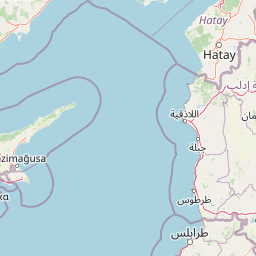
Map view of Ethniko Dasiko Parko Potamos Liopetriou

Use this park location map to pinpoint Ethniko Dasiko Parko Potamos Liopetriou in Cyprus, understand its exact geographic position, and read its mapped placement within the surrounding landscape more clearly.

Pigeon | © OpenStreetMap contributors
Park atlas

Compare surrounding Mediterranean coastal habitats and regional reserves

Explore Protected Areas Near Ethniko Dasiko Parko Potamos Liopetriou

Continue browsing other parks near Ethniko Dasiko Parko Potamos Liopetriou to examine related coastal wetlands and protected landscapes across the region. Regional park comparison reveals broader ecological patterns among southeastern Mediterranean reserves.
Protected areaCyprus
About 0.3 km away#1 closest

East

Periochi Agias Theklas - Liopetri: Protected Coastal Geography and Bird Habitat

Natura 2000 protected area in the Famagusta Bay region

Periochi Agias Theklas - Liopetri is a compact coastal site in southeastern Cyprus known for its bird-focused conservation efforts. Within its boundaries, the landscape features low-lying Mediterranean scrub, open ground, and agricultural edges that provide refuge for waders, herons, and migratory species. This site plays an essential role in maintaining ecological connectivity within the Mediterranean flyway.

Area
0.698 km²
Established
2008
Relief
Lowland
Scope
Terrestrial
A soft watercolor illustration showing rolling green hills and a coastal shoreline with sparse vegetation.
Protected areaFamagusta
About 11 km away#2 closest

East

Kavo Gkreko: A Protected Coastal Landscape Atlas in the Famagusta District of Cyprus

Mapped limestone cliffs, seagrass meadows, and marine habitats.

Discover the geographic essence of Kavo Gkreko, a vital protected area on the southeastern tip of Cyprus. This record examines the unique intersection of terrestrial juniper matorral and submerged reef systems. Gain insight into the coastal cliffs, sea caves, and Mediterranean habitats that define this site as a key reference for regional conservation geography.

Area
18.754 km²
Established
2004
Relief
Mixed relief
Climate
Mediterranean
Wildlife reserveCyprus
About 15 km away#3 closest

Northeast

Deryneia (Vogelschutzgebiet) Wildlife Reserve: Protected Coastal Geography in Cyprus

Coastal phrygana shrubland and migratory bird habitat.

Deryneia (Vogelschutzgebiet) is a unique coastal protected area in Cyprus, defined by its small size and strategic position within the UN buffer zone. This wildlife reserve features steep terrain and phrygana vegetation, creating a vital, low-disturbance stopover for migratory birds traversing the Mediterranean flyway. Gain a structured understanding of its mapped boundaries and physical landscape through the MoriAtlas database.

Area
0.057 km²
Established
2021
Relief
Lowland
Scope
Terrestrial
Nature reserveCyprus
About 23 km away#4 closest

West

Periochi Kosiis - Pallourokampou Nature Reserve: Regional Geography and Protected Boundaries

Inland Cyprus protected landscape and natural terrain mapping

Periochi Kosiis - Pallourokampou represents a crucial nature reserve within the Mediterranean ecoregion of Cyprus. Examine the park boundaries and regional geographic context through this structured atlas entry, which details the terrestrial landscape features defining this inland conservation area.

Area
37.178 km²
Established
2007
Climate
Mediterranean
Scope
Terrestrial
A horizontal watercolor illustration of a wetland scene with a calm body of water, grassy shorelines, and distant rolling hills under a soft sky.
Nature reserveLarnaca District
About 25 km away#5 closest

West

Alykes Larnakas Nature Reserve: Atlas of Protected Wetlands and Coastal Mediterranean Terrain

Ecological landscape mapping in the Larnaca District of Cyprus

Alykes Larnakas functions as a cohesive wetland landscape featuring the expansive Larnaka Salt Lake alongside smaller basins like Orfani and Soros. The reserve protects a gradient of ecosystems ranging from coastal lagoons and salt-crust basins to Mediterranean phrygana and dry grassland textures that define the southeastern coast of Cyprus.

Area
15.602 km²
Established
2008
Protected areaCyprus
About 29 km away#6 closest

West

Ethniko Dasiko Parko Rizoelias: A Natura 2000 Protected Area and Mediterranean Habitat Mosaic

Ecological geography and landscape context in inland Cyprus

Ethniko Dasiko Parko Rizoelias represents a significant conservation effort in Cyprus, balancing rare gypsophilous vegetation with Mediterranean shrubland. Its triple Natura 2000 status protects 34 bird species and reptile communities within a compact, structurally diverse terrestrial environment.

Area
1.238 km²
Established
2004
Relief
Lowland
Climate
Mediterranean
Protected areaTajikistan
About 34 km away#7 closest

West

Periochi Moytti Toy Ziou: Protected Landscape and Geographic Overview in Tajikistan

Mapped boundaries and regional protected area context

Discover the geographic identity of Periochi Moytti Toy Ziou, a key protected area situated in Tajikistan. This entry provides essential mapping and landscape data to help visualize the park's boundaries, surrounding terrain, and its contribution to regional conservation geography.

Area
0.181 km²
Relief
Lowland
Scope
Terrestrial
Water
Minor water
Protected areaCyprus
About 36 km away#8 closest

West

Potamos Panagias Stazousas Protected Area: Geography and Landscape of Central Cyprus

Riverine corridors and Mediterranean avian habitats

Potamos Panagias Stazousas represents a core protected area in inland Cyprus, recognized primarily for its rich birdlife and distinct river-centered geography. This site showcases a diverse Mediterranean mosaic of scrubland, farmland, and woodland, providing critical ecological connectivity within the eastern Mediterranean basin.

Area
17.45 km²
Established
2007
Climate
Mediterranean
Scope
Terrestrial

Common questions about visiting, size, designation, and location context for Ethniko Dasiko Parko Potamos Liopetriou

Ethniko Dasiko Parko Potamos Liopetriou FAQs for park facts, access, geography, and protected area context

Find quick answers about Ethniko Dasiko Parko Potamos Liopetriou, including protected-area facts, park geography, trail and visitor context, and how the park fits into its surrounding country and regional landscape.
MoriAtlas Explorer

Continue Your Protected Areas Search Across the Global Atlas

Deepen your exploration by continuing the structured search for national parks and protected areas worldwide. Utilize the comprehensive filtering capabilities to compare different conservation landscapes and refine your understanding of global park geography. Discover more about the distribution and characteristics of protected natural areas.

Global natural geography