Why Francois Peron National Park stands out
Francois Peron National Park is best known for its dramatic red cliff landscapes along the Peron Peninsula coastline, particularly the vivid ochre formations at Bottle Bay that stand in striking contrast to the turquoise waters of Shark Bay. The park protects exceptional examples of birrida saline flat ecosystems, unique geomorphological features that develop intricate salt crust patterns across their surfaces. The park's location within the Shark Bay World Heritage Area places it alongside globally significant coastal and marine environments, with the adjacent marine park creating one of Australia's largest integrated terrestrial and marine protected area complexes. The combination of French exploration heritage, 26,000 years of Aboriginal connection, and the dramatic transition from pastoral use to conservation protection gives the park a distinctive cultural landscape character.
Francois Peron National Park history and protected-area timeline
The human history of Francois Peron National Park spans at least 26,000 years of continuous Aboriginal occupation by the Malgana people, whose cultural connection to the land predates European arrival by many millennia. The French scientific expedition led by Nicolas Baudin, which visited Western Australia in 1801 and 1803, brought naturalist François Péron to the region, and several geographical features on the peninsula retain names from this exploration including Cape Lesueur, Guichenault, and Lake Montbazin. Following European settlement, the peninsula was established as Peron Station, a pastoral lease used for sheep grazing from the early 1900s onward. The pearling industry also left its mark on the region, with a camp established at Herald Bight in the 1880s, and remnants of pearl shell deposits can still be found along beaches within the park today. The Western Australian government acquired Peron Station in 1990, ending nearly a century of pastoral use, and the land was officially gazetted as a national park on 8 January 1993, formally establishing the protection regime that continues today.
Francois Peron National Park landscape and geographic character
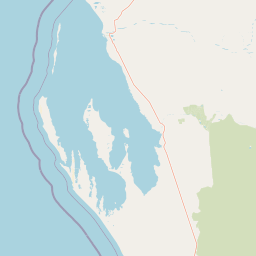
The landscape of Francois Peron National Park is defined by the dramatic contrast between its red earth and the turquoise waters of Shark Bay that surround the Peron Peninsula on three sides. The most visually striking geological features are the red cliff formations along the western coastline, particularly at Bottle Bay where vertical ochre walls rise sharply from the shoreline, creating a landscape of considerable visual impact. The interior of the peninsula contains extensive sandplain and dune systems, while the unique birrida saline flats represent a distinctive landscape element found throughout the park. These birrida form in depressions where saline groundwater rises close to the surface, creating mudflat environments that develop thick salt crusts during dry periods. The coastal margin features several lagoon systems including Big Lagoon, where shallow protected waters provide contrast to the open ocean exposures along the western coastline. The overall landform creates a peninsula environment where terrestrial and marine landscapes intersect continuously along the shoreline.
Francois Peron National Park ecosystems, habitats, and plant life
The ecological character of Francois Peron National Park reflects its position within the Shark Bay World Heritage Area, one of the world's most significant coastal and marine environments. The park protects a transition zone between arid inland environments and productive marine systems, creating habitats that support both desert-adapted species and marine-dependent wildlife. The birrida saline flat environments represent highly specialised ecosystems adapted to extreme salinity, supporting specialized vegetation communities and invertebrate fauna adapted to these harsh conditions. The coastal dune systems support distinct plant communities adapted to shifting sandy substrates and salt-laden winds, while the red cliff formations provide nesting habitat for seabirds and support specialized rock-dwelling species. The integration with Shark Bay Marine Park ensures protection for the broader ecological processes that connect terrestrial and marine systems, including the seasonal movements of marine mammals, seabirds, and migratory fish species that depend on the coastal interface.
Francois Peron National Park wildlife and species highlights
The wildlife of Francois Peron National Park reflects the park's position at the intersection of desert and marine ecosystems within the Shark Bay World Heritage Area. Coastal waters support marine mammals including dolphins that frequent the bays and lagoons along the peninsula, while seabirds utilize the cliff formations and beach areas for nesting and feeding. The birrida environments, despite their harsh appearance, support specialized invertebrate communities and attract bird species adapted to saline wetland conditions, particularly during periods when rain creates temporary freshwater pooling. The terrestrial portions of the park provide habitat for desert-adapted reptiles and small mammals, though the relatively recent transition from pastoral use means that some wildlife populations are still recovering from historical grazing impacts. The surrounding marine park waters support significant populations of fish, crustaceans, and marine reptiles that form part of the broader Shark Bay ecosystem recognized for its global ecological significance.
Francois Peron National Park conservation status and protection priorities
Francois Peron National Park contributes to one of Australia's most significant conservation outcomes as a core component of the Shark Bay World Heritage Area, recognised internationally for its outstanding universal values. The park protects the terrestrial portion of the Peron Peninsula while surrounding marine waters receive equivalent protection through Shark Bay Marine Park, creating one of Australia's largest integrated terrestrial and marine protected area complexes. The birrida ecosystems represent particularly significant conservation values, as these highly specialized saline environments are limited in distribution and support unique biological communities adapted to extreme conditions. The park's inclusion in the World Heritage area reflects recognition of the region's ecological processes, biodiversity, and the exceptional combination of natural and cultural values that the area embodies. The transition from pastoral use to formal protection in 1993 represents the culmination of conservation efforts to secure this distinctive landscape for ongoing protection.
Francois Peron National Park cultural meaning and human context
The cultural context of Francois Peron National Park encompasses both Aboriginal heritage spanning at least 26,000 years and the more recent colonial history tied to European exploration and pastoral development. The Malgana people are the traditional custodians of the land, maintaining cultural connections to the landscape that extend deep into pre-historic times, and the area's Aboriginal name Wulyibidi reflects this enduring relationship with country. The French exploration period of the early 1800s left a distinctive naming legacy on the peninsula, with features like Cape Lesueur and Guichenault preserving the names given by Nicolas Baudin's expedition members. The pastoral era from the early 1900s until 1990 fundamentally shaped the landscape through sheep grazing, though the transition to national park protection has allowed for ongoing recovery of ecological values. The combination of Aboriginal heritage, French exploration history, and pastoral transition creates a multi-layered cultural landscape that adds depth to the park's identity beyond its natural values.
Top sights and standout views in Francois Peron National Park
Francois Peron National Park offers visitors dramatic coastal scenery dominated by the striking red cliff formations at Bottle Bay, where vertical ochre walls create one of the most visually memorable landscapes in Western Australia's coastal park system. The unique birrida saline flats represent a distinctive highlight, with their intricate salt crust patterns creating an almost surreal landscape unlike typical Australian outback environments. Several accessible locations along the western coast including Big Lagoon, Cape Lesueur, and Bottle Bay provide opportunities for camping, picnicking, and boat launching, while the network of tracks throughout the park enables exploration of the peninsula's diverse landscapes. The integration with Shark Bay Marine Park means that visitors can experience both terrestrial and marine environments within a single visit, moving from red cliff viewpoints to turquoise waters and sandy beaches within minutes of travel.
Best time to visit Francois Peron National Park
The cooler months from April to October represent the most comfortable time to visit Francois Peron National Park, when daytime temperatures are moderate and conditions allow for sustained outdoor exploration. Summer months from November to March bring significantly higher temperatures that can make outdoor activities challenging, though early morning and late afternoon visits remain possible. The landscape appears most vibrant after rainfall, when the red earth takes on deeper tones and the birrida may hold temporary pools of water that attract birdlife. The shoulder seasons of autumn and spring offer a balance of comfortable temperatures and the chance to experience the park in more varied conditions, though any season provides opportunities to appreciate the park's core landscapes and the World Heritage values it protects.