Mori Atlas logo
Nature reserveFriedrichsheider Hochmoor

Discover the unique geography and mapped boundaries of this intact subarctic watershed raised bog

Friedrichsheider Hochmoor Nature Reserve in Sachsen: Protected Bog and Mountain Landscape Atlas

(Naturschutzgebiet Friedrichsheider Hochmoor)

Friedrichsheider Hochmoor represents a high-elevation protected landscape in the western Erzgebirge of Sachsen, Germany, where a significant watershed raised bog continues to thrive. Spanning 19 hectares, the reserve showcases a diverse mosaic of bog pine forests and regenerating peatland communities that remain rare across the regional geography. This site provides a vital reference for subarctic-boreal vegetation and active peatland restoration within the broader Natura 2000 network.

Sphagnum raised bogBog pine forestMountain peatlandErzgebirge moorSubarctic-boreal floraNatura 2000 site

Friedrichsheider Hochmoor

Nature reserve

Park overview

Structured park overview, official facts, and landscape profile for Friedrichsheider Hochmoor

Friedrichsheider Hochmoor park facts, protected area profile, and essential visitor context

Review the core facts for Friedrichsheider Hochmoor, including designation, size, terrain, visitor scale, habitats, and operating context in one park-focused overview.

About Friedrichsheider Hochmoor

Friedrichsheider Hochmoor lies in the western part of the Erzgebirge mountain range, on a high plateau southeast of Sosa and at the foot of the Auersberg. Although small, it captures a slice of one of the most ecologically distinctive landscape types historically found in the Saxon high Erzgebirge: intact, waterlogged peatland at roughly 800 meters elevation, set between older spruce forests and the characteristic dwarf shrub communities that line Saxony's surviving bogs.

The protected landscape is not a uniform sheet of bog. Most of the site is forested, with a central core of bog pine woodland that has rebuilt itself on top of a thick peat body. A smaller area in the west is largely open and represents what is expected to become, through natural regeneration, a more classic open raised bog. Around the edges, spruce stands give way to spruce moor forest, and the bog communities blend into mountain pine and dwarf shrub heath with blueberry, bog bilberry, cowberry, crowberry, and a wide variety of Sphagnum mosses. Nine species of Sphagnum have been recorded, alongside notable vascular plants such as round-leaved sundew, hare's-tail cotton grass, and bog rosemary.

The reason this site matters far beyond its 19 hectares is that raised bogs and bog pine forests are among the most severely reduced habitat types in Saxony. Historically they covered a much larger area of the Erzgebirge highlands, but centuries of peat cutting, drainage for forestry and agriculture, and later industrial pressures eliminated nearly all of them. Friedrichsheider Hochmoor survives because, despite the same kinds of disturbance elsewhere around it, a substantial part of its peat body and its characteristic species assemblage has been preserved, and because active management and restoration work has been directed at the surrounding ditches and former cutover areas. As a result, the reserve stands today as a reference site for what Saxony's Erzgebirge bogs once were and what future restoration projects hope to recreate elsewhere.

Within the European statutory framework, the reserve sits inside the Natura 2000 site designated as "Mittelgebirgslandschaft bei Johanngeorgenstadt." That larger designation gave a 2011 ordinance of the Landesdirektion Chemnitz formal EU-level protection under the Habitats Directive, and the mountain pine bog forest habitat at Friedrichsheider is classified as a priority feature of the site.

Quick facts and research context for Friedrichsheider Hochmoor

Friedrichsheider Hochmoor is a state-level nature reserve (Naturschutzgebiet) in the Erzgebirgskreis of Saxony, Germany, with an area of approximately 19 hectares and an elevation around 800 meters above sea level. It was formally protected on 11 September 1967 by an order of the Chairman of the Agricultural Council of the German Democratic Republic, and it is also part of the EU Natura 2000 site known as "Mittelgebirgslandschaft bei Johanngeorgenstadt."

Administratively it falls under the Erzgebirgskreis and is managed in cooperation with the Saxon state forest agency (Staatsbetrieb Sachsenforst). Its core is classified under the EU Habitats Directive as priority habitat type 91D3 (mountain pine bog woodland, or Spirken-Moorwald), while a smaller western area represents a regenerable degraded raised bog of type 7120.

Protection and recognition

Documented conservation status and international recognition data

Friedrichsheider Hochmoor Protection Status and Designated Area Record

Examine the official protection status, management scope, and verified registry records associated with Friedrichsheider Hochmoor. Structured environmental data provides clear reference points for tracking conservation frameworks and protected area designations.

Protection details

WDPA ID
163152
Park context

Deeper park guide and search-rich context for Friedrichsheider Hochmoor

Friedrichsheider Hochmoor history, landscape, wildlife, and travel context

Explore Friedrichsheider Hochmoor through its history, landscape character, ecosystems, wildlife, conservation priorities, cultural context, and seasonal travel timing in a structured park guide built for atlas discovery and search intent.

Why Friedrichsheider Hochmoor stands out

Friedrichsheider Hochmoor is best known for being one of the most intact and best-developed examples of a Spirken moor forest (Bergkiefern-Moorwald) in Saxony. This habitat, dominated by the bog pine Pinus rotundata, grows directly on a peat body more than a meter thick and supports a near-complete assemblage of typical bog species in its herb and cryptogam layers, including multiple Sphagnum mosses, cranberry species, crowberry, bog rosemary, round-leaved sundew, and hare's-tail cotton grass. The reserve is also notable for representing a watershed raised bog (Wasserscheiden-Hochmoor), a type of mire that originally formed on a flat or gently sloping surface that does not drain in any single direction. Although the surrounding bog landscape has been heavily degraded by past peat cutting, drainage, and timber extraction, the core of Friedrichsheider Hochmoor has returned to a typical, ecologically stable state and is treated by the Saxon state environmental ministry as a site of statewide significance.
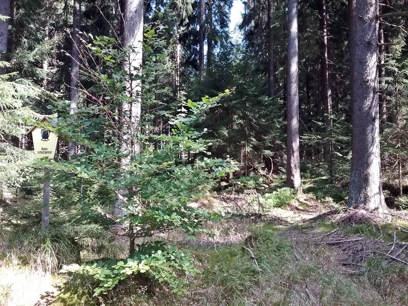
A small yellow trail marker sign attached to a post in a dense forest, with sunlight filtering through the trees.
A trail marker sign within the Friedrichsheider Hochmoor nature reserve.

Friedrichsheider Hochmoor history and protected-area timeline

The natural bog landscape of which Friedrichsheider Hochmoor is a remnant once extended more widely across the high Erzgebirge plateau south of Sosa. That wider system was progressively altered by drainage, peat extraction, and forest clearance, with peat cutting in the peripheral slopes of the Friedrichsheider moor continuing into the post-1945 period.

The present reserve owes its existence to an order of the Chairman of the Agricultural Council of the German Democratic Republic dated 11 September 1967, published in the GBl. DDR II at page 697, which placed Friedrichsheider Hochmoor under formal protection as a Naturschutzgebiet. Despite the long history of disturbance around it, the central core of the bog had survived, and over time it returned to a near-natural state of bog pine woodland over peat.

In 2011, the Landesdirektion Chemnitz issued the ordinance formally designating "Mittelgebirgslandschaft bei Johanngeorgenstadt" as a Site of Community Importance, incorporating Friedrichsheider Hochmoor within the EU Natura 2000 network. The accompanying annex explicitly recognized the site for its statewide significance in Saxony.

A more recent chapter began in 2016, when environmental agencies and the Saxon state forest agency approved a revitalization feasibility study under the state's Erzgebirgische Moore priority project. The drainage ditches associated with the moor, located at the northern and southern edges, were blocked with timber pile dams and sheet pile dams, and the dams were covered with geotextile and existing peat, to begin re-wetting the peatland. The work was funded through the state's Natürliches Erbe funding line.

Friedrichsheider Hochmoor landscape and geographic character

The physical setting of Friedrichsheider Hochmoor is a high-elevation plateau in the western Erzgebirge, near 800 meters above sea level, southeast of the village of Sosa and below the slopes of the Auersberg. The site itself is a classic example of a Wasserscheiden-Hochmoor, a watershed raised bog formed on terrain without a strong directional slope.

The reserve's surface is flat to gently undulating, dominated by a continuous peat body roughly a meter or more in thickness that holds water and supports the characteristic bog vegetation. Around this core, the terrain transitions through several distinct vegetation zones, from open bog with low dwarf shrubs and mosses, to thin, open stands of bog pine, to denser spruce and spruce moor forest at the margins. The site is bordered southward toward the Riesenberger Häuser, and lies along forest roads including the Milchbachweg, which runs roughly west to east along the southern boundary.

Friedrichsheider Hochmoor ecosystems, habitats, and plant life

Ecologically, Friedrichsheider Hochmoor is dominated by peatland ecosystems. The central habitat is a well-developed bog pine woodland over thick peat, classified under the EU Habitats Directive as priority habitat type 91D3. The bog pine, or Spirke (Pinus rotundata), forms both the canopy and a noticeable understory, and the herb and cryptogam layers are diverse, dense, and near-complete. Sphagnum mosses dominate the ground layer; surveys in 2000 and 2002 documented 49 moss species within the reserve, including nine Sphagnum species such as Sphagnum balticum, Sphagnum magellanicum, and Sphagnum tenellum.

The supporting plant communities are equally characteristic. Dwarf shrubs such as blueberry (Vaccinium myrtillus), bog bilberry or Rauschbeere (Vaccinium uliginosum), cowberry or Preiselbeere (Vaccinium vitis-idaea), and crowberry (Empetrum nigrum) form much of the field layer. Several typically more open-bog species are also present, including cranberry or Moosbeere (Vaccinium oxycoccus), bog rosemary (Andromeda polifolia), round-leaved sundew (Drosera rotundifolia), and hare's-tail cotton grass (Eriophorum vaginatum). Together these represent the subarctic and boreal plant signature that still survives in the few remaining Sphagnum-rich mires of the Erzgebirge.

A small western zone of the reserve is now largely open and is expected, with rewetting, to regenerate toward a classic open raised bog of habitat type 7120, while the eastern part is dominated by spruce-dominated bog forest (Vaccinio uliginosi-Piceetum). Mountain pine (Pinus mugo agg., the Bergkiefer) occurs around the margins.

Friedrichsheider Hochmoor wildlife and species highlights

The available source material focuses primarily on the botanical and habitat character of Friedrichsheider Hochmoor and does not provide detailed species lists for its fauna. The reserve's wildlife significance is therefore best understood indirectly, through its ecological function: a continuously waterlogged, Sphagnum-rich peatland with a mosaic of open bog, bog pine forest, and spruce moor forest in a Saxon high-mountain setting. Such habitats typically support specialist bog invertebrates and a distinctive bird assemblage adapted to mires, including species that depend on open, wet bog surfaces and on the structurally varied bog pine and spruce forests surrounding them.

Without more directly supported detail, the reserve should be understood primarily as a botanical, habitat, and peatland conservation site. Where specific animal records exist beyond the published sources accessed here, they would come from the broader Natura 2000 management plan for "Mittelgebirgslandschaft bei Johanngeorgenstadt."

Friedrichsheider Hochmoor conservation status and protection priorities

Friedrichsheider Hochmoor is a conservation site of statewide, and arguably supra-regional, significance. The Saxon state environmental ministry's management plan for the surrounding Natura 2000 site treats it as one of the best, if not the single best, example of a Spirken-Moorwald (bog pine forest) in Saxony, and assigns it statewide importance.

This status reflects the extreme scarcity of the habitat. Raised bogs and bog pine forests were once widespread across the upper Erzgebirge but have been reduced to a handful of small remnants through centuries of peat cutting, drainage for forestry and agriculture, and vegetation clearance. Today the few intact or regenerable bog areas that remain in Saxony are considered exceptionally valuable, particularly the priority habitat type 91D3 with its characteristic bog pine (Pinus rotundata), which is restricted in the state to the montane elevations of the Erzgebirge. Friedrichsheider is distinguished within that already narrow set by the scale and completeness of its species assemblages, including a near-complete herb and cryptogam layer over a thick, intact peat body.

Modern conservation management has moved the site from a passive protection model toward active restoration. Following the 2011 Natura 2000 designation, a 2016 revival plan, developed with the Saxon state forest agency under the Landesschwerpunktprojekt Erzgebirgische Moor priority project and financed through the Natürliches Erbe funding line, closed off drainage ditches around the mire using pile dams and sheet pile dams, sealed them with geotextile and peat, and began the process of rewetting the cutover areas. This active approach aims to secure the long-term survival of the priority bog forest habitat and to restore additional open bog surface.

Top sights and standout views in Friedrichsheider Hochmoor

Friedrichsheider Hochmoor stands out for the rare combination of features it preserves in a very small area: a thick, still-intact peat body, a near-complete bog pine forest on top of that peat, a diverse Sphagnum-dominated cryptogam flora, and a set of subarctic-boreal indicator species that have otherwise largely disappeared from Saxony's landscape.

The reserve is also a textbook example of successful bog restoration in a German Mittelgebirge setting, with documented conservation history going back to the late 1960s, EU Natura 2000 status from 2011, and a focused rewetting program begun in 2016. Combined, these layers of protection and restoration make it a reference site for peatland recovery not only in the Erzgebirge but in Saxony as a whole.

Best time to visit Friedrichsheider Hochmoor

Friedrichsheider Hochmoor is a quiet peatland site that can be appreciated in any frost-free season. Late spring and summer bring the most active growth, when the Sphagnum carpets are green, the cotton grass tufts stand out across open bog patches, and the round-leaved sundew can be found flowering along wet edges. In autumn the dwarf shrub communities of blueberry, bog bilberry, cowberry, and crowberry take on color, and the bog pine forest above the peat is at its most visible from the surrounding forest tracks. In winter, when the snow lies, the open, relatively flat character of raised bogs is most clearly visible from the air and from approach paths, but deep snow, ice, and the sensitivity of the bog surface make winter visits more cautious than lowland outings.

Monthly climate preview

Review long-term temperature ranges and monthly precipitation averages across the protected terrain.

Friedrichsheider Hochmoor Climate Normals and Annual Temperature Patterns

Representative coordinate records show measured monthly temperature variations and precipitation distribution across the protected landscape from 1991 to 2020. Examining the complete twelve-month profile provides deeper insight into long-term climate normals and seasonal weather patterns.
Annual mean7 °C
-3 °C17 °C
Jan-3°
Feb-2°
Mar
Apr
May12°
Jun15°
Jul17°
Aug17°
Sep13°
Oct
Nov
Dec-1°
Warmest month
July

17.5 °C

Coolest month
January

-2.5 °C

Wettest month
July

2.8 mm/day

Driest month
April

1.4 mm/day

Park location guide

Geography guide, regional context, and park location map for Friedrichsheider Hochmoor

Friedrichsheider Hochmoor park geography, regions, and map view in Germany

Understand where Friedrichsheider Hochmoor sits in Germany through a broader geographic reading of the surrounding landscape, nearby location context, and its mapped position within the national park landscape.

How Friedrichsheider Hochmoor fits into Germany

Germany is a federal republic in Western and Central Europe with a population of over 83 million across sixteen constituent states. It is Europe's largest economy by nominal GDP and a major global exporter and importer. The capital is Berlin, and the country borders Denmark, Poland, Czech Republic, Austria, Switzerland, France, Luxembourg, Belgium, and the Netherlands.

Wider geography shaping Friedrichsheider Hochmoor in Germany

Germany is located in Western and Central Europe, spanning 357,022 km². It borders Denmark to the north, Poland and the Czech Republic to the east, Austria and Switzerland to the south, and France, Luxembourg, Belgium, and the Netherlands to the west. The country has coastlines on the Baltic Sea and North Sea to the north, with the Alps located in the southern region.

Map view of Friedrichsheider Hochmoor

Use this park location map to pinpoint Friedrichsheider Hochmoor in Germany, understand its exact geographic position, and read its mapped placement within the surrounding landscape more clearly.

Pigeon | © OpenStreetMap contributors

Location context for Friedrichsheider Hochmoor

Sachsen

Visualizing the rare bog pine forest, peatland terrain, and high-elevation habitats of the Erzgebirge reserve.

Friedrichsheider Hochmoor Photos and Landscape Scenery Exploration

Visual documentation captures the unique terrain, characteristic bog pine woodland, and peatland habitats of Friedrichsheider Hochmoor across the high-elevation Erzgebirge plateau. Examining these protected-area views helps researchers and visitors understand the rare ecological structure of Saxony's most intact watershed raised bog.

A small yellow trail marker sign attached to a post in a dense forest, with sunlight filtering through the trees.

Park atlas

Compare nearby mountain reserves and connected protected landscapes across the region

Other Parks Near Friedrichsheider Hochmoor and Surrounding Protected Areas

Browse adjacent protected areas and nature reserves located near Friedrichsheider Hochmoor in the western Erzgebirge. Expanding the geographic view helps visitors compare similar highland peatlands and regional conservation landscapes.
Watercolor painting of a flat marshy landscape with a small winding stream in the foreground, green trees in the midground, and soft purple mountain silhouettes in the distance.
Nature reserveSaxony
About 8.1 km away#1 closest

Southwest

Großer Kranichsee Nature Reserve: Protected Raised Bog Geography and Ore Mountain Landscapes

Watershed moorland, mountain pine forests, and Saxony high plateau geography.

Großer Kranichsee serves as a primary example of an intact raised bog system in the Ore Mountains. The reserve features rare peat-forming vegetation and highland bog forests, occupying a high-altitude plateau that bridges the border between Saxony and the Czech Republic. Its geographic significance stems from its role as a triple watershed, defining the drainage patterns for three distinct regional river systems within the protected Erzgebirgskamm zone.

Area
6.11 km²
Established
1912
Nature reserveSachsen
About 8.2 km away#2 closest

North

Conradswiese Nature Reserve: Geographic Overview of the Saxon Ore Mountains Forest Meadow

Protected mountain meadow and mixed forest terrain in Sachsen.

Conradswiese encompasses a distinct Waldwiese clearing embedded within the Bergmischwald of the western Ore Mountains. Located near the Morgenleithe, this nature reserve is positioned along a watershed boundary between two river systems, making it a point of geographic interest for those exploring the natural heritage and silvicultural history of Germany.

Area
38.97 km²
IUCN
IV
A horizontal watercolor illustration of a gentle landscape with scattered trees, soft green foliage, and faint mountain outlines in the background.
Nature reserveSaxony
About 8.4 km away#3 closest

West

Am Riedert Nature Reserve: Protected Mountain Forest Geography in Saxony, Germany

Analyzing the ecological boundaries and Hercynian mountain mixed forest terrain

Am Riedert is a compact but ecologically important nature reserve situated on the rugged slopes of the western Erzgebirge. This site protects a significant example of mountain mixed forest, characterized by its mature silver fir populations and active natural regeneration. By examining its location south of the Zwickauer Mulde river, visitors can trace the intersection of Saxon history and conservation within this unique protected landscape.

Area
0.185 km²
Established
1961
IUCN
IV
Relief
Mountain
A horizontal watercolor painting showing rolling green hills and distant mountain ridgelines behind a foreground of grassy meadows and trees.
Nature reserveSaxony
About 10 km away#4 closest

Southwest

Dreibächel Nature Reserve: Mapping the Old-Growth Spruce Stands of the Western Ore Mountains

A historic protected landscape and mountain watershed in Saxony, Germany

Dreibächel serves as a living archive of traditional forest management, holding the distinction of containing the oldest spruce trees in Saxony. Located on the slopes of the Schneehübel, the reserve is characterized by a dense, multi-layered mountain forest canopy and the confluence of three vital streams. The area remains a essential site for observing historical plenterwald ecology and the natural hydrology of the Westerzgebirge region.

Area
0.147 km²
Established
1961
IUCN
IV
Natural monumentKarlovarský kraj
About 11 km away#5 closest

Southeast

Vlčí jámy Natural Monument: Protected Geological and Industrial Heritage in Bohemia

Ore Mountains mining collapse and relict microclimate landscape

Vlčí jámy protects a rare intersection of medieval mining history and environmental significance in the Karlovarský kraj. The site is defined by two deep collapse features, Ledová jáma and Vlčí jáma, which function as persistent cold traps. These geological anomalies support critically endangered mosses and bat colonies, illustrating how abandoned industrial landscapes in the Ore Mountains evolve into essential, small-scale protected habitats.

Area
0.014 km²
Established
1975
IUCN
III
Relief
Mountain
Nature reserveSaxony
About 12 km away#6 closest

Northwest

Heide und Moorwald am Filzteich: Nature Reserve and Bog Landscape in Saxony

Protected moorland forest and heathland geographic context

Heide und Moorwald am Filzteich provides a unique look at habitat management in the Erzgebirge region. This nature reserve, adjacent to the Filzteich reservoir, encompasses a protected mosaic of open heath, remnant bog systems, and historical peatland terrain. Its geographic boundaries offer insights into the transitional landscapes of the Saxon uplands and local water table influences on wetland biodiversity.

Area
3.14 km²
Established
2010
IUCN
IV
A horizontal watercolor illustration depicting a soft, green, mountain landscape with hills, conifers, and a waterlogged meadow.
Natural monumentKarlovy Vary Region
About 13 km away#7 closest

South

Rudenská luční prameniště Natural Monument: Protected Mountain Wetland Atlas

Karlovy Vary Region Ore Mountains landscape mapping

Rudenská luční prameniště is a protected mountain wetland in the Ore Mountains, defined by a distinct mosaic of spring fens, peat deposits, and mountain meadows. Its geographic layout, spanning twenty three hectares across sloping terrain, creates a vital drainage system for the local landscape. By examining this protected site, you can better understand the unique hydrological and botanical features that distinguish these rare mountain mire complexes from the surrounding highland forests.

Area
0.232 km²
Established
2020
IUCN
IV
Relief
Mountain
Nature reserveSachsen
About 19 km away#8 closest

North

Hartensteiner Wald Nature Reserve: Saxon Protected Landscapes and Regional Geography

Woodland habitat and river valley terrain in Zwickau

Hartensteiner Wald functions as a key Natura 2000 protected area within the Free State of Sachsen. This reserve offers a layered landscape of native beech woodlands, steep valley slopes, and striking rocky outcrops along the Zwickauer Mulde. Use this atlas perspective to map the reserve's historic features, such as the Prinzenhöhle and Knoblauchfelsen, while understanding its conservation role in the broader Erzgebirge transition zone.

Area
0.89 km²
Established
1961
IUCN
IV
Relief
Upland

Common questions about visiting, size, designation, and location context for Friedrichsheider Hochmoor

Friedrichsheider Hochmoor FAQs for park facts, access, geography, and protected area context

Find quick answers about Friedrichsheider Hochmoor, including protected-area facts, park geography, trail and visitor context, and how the park fits into its surrounding country and regional landscape.
MoriAtlas Explorer

Continue Your Protected Areas Search Across the Global Atlas

Deepen your exploration by continuing the structured search for national parks and protected areas worldwide. Utilize the comprehensive filtering capabilities to compare different conservation landscapes and refine your understanding of global park geography. Discover more about the distribution and characteristics of protected natural areas.

Global natural geography