Why General Juan Pablo Peñaloza National Park stands out
General Juan Pablo Peñaloza National Park is best known for its exceptional high-altitude páramo ecosystem and the extraordinary concentration of glacial lagoons that dot its landscape. The páramo environment, unique to the northern Andes, represents one of the world's most specialized alpine ecosystems, and this park protects some of its finest examples in Venezuela. The lagoon of Bobo River (Babu), Laguna Grande, Laguna Verde, and Laguna Negra rank among the most visually striking water bodies, set against backdrop of steep Andean ridges and remaining glacier fields. The park's significance as a water source cannot be overstated, as it originates more than a dozen rivers that collectively sustain hydroelectric power generation and agricultural water supply across western Venezuela.
General Juan Pablo Peñaloza National Park history and protected-area timeline
General Juan Pablo Peñaloza National Park was officially established on January 18, 1989, through Venezuelan governmental decree, recognizing the exceptional ecological and hydrological importance of the Páramos de El Batallón and La Negra. The park was named in honor of General Juan Pablo Peñaloza, a significant figure in Venezuelan military history, reflecting the national tradition of commemorating historical leaders through protected area designations. Prior to national park status, the páramo regions had long served as critical watersheds for the surrounding agricultural communities and growing urban centers of Mérida and Táchira states. The decision to elevate protection to national park status came amid increasing recognition of the threats facing high-altitude páramo ecosystems, including expanding agricultural frontier, livestock grazing pressure, and the ecological consequences of hydrological modification. The park's creation also acknowledged the need to preserve the headwaters of the rivers feeding the Uribante-Caparo hydroelectric complex, which had become operational in the 1970s and represented a major investment in regional power generation. Since establishment, the park has faced ongoing challenges balancing conservation objectives with the needs of local communities and regional development pressures, a common dynamic in Venezuelan protected area management.
General Juan Pablo Peñaloza National Park landscape and geographic character
The landscape of General Juan Pablo Peñaloza National Park is defined by its dramatic Andean topography and the legacy of glacial processes that have shaped the region over millennia. The park encompasses several connected mountain ranges with elevations ranging from 1,800 meters in the lower foothills to 3,942 meters at the summit of El Pulpito, the highest peak in Táchira state. The relief is exceptionally rugged, characterized by steep slopes, sharp ridges, and deep valley incisions where rivers have cut through the terrain. Among the most striking features are the more than 130 periglacial lagoons scattered throughout the park, occupying glacial cirques and depressions carved by ancient ice sheets. These lagoons vary considerably in size and character, with notable examples including the lagoon of Bobo River (also known as Babu), Laguna Grande, Laguna Verde, Laguna Negra, Laguna Piedra, and Laguna Hoyo Grande. The waters of these lagoons display remarkable clarity and vivid colors, ranging from turquoise to deep green depending on mineral content and surrounding vegetation. Steep slopes dominate much of the park's terrain, and in certain sectors, remaining glaciers cling to north-facing walls, providing visual evidence of the region's cryospheric heritage. The combination of high peaks, glacial lagoons, steep descents, and continuous water flow creates one of the most scenically dramatic protected landscapes in Venezuela.
General Juan Pablo Peñaloza National Park ecosystems, habitats, and plant life
The nature of General Juan Pablo Peñaloza National Park centers on its páramo ecosystem, one of the most distinctive and ecologically specialized biomes in the world. Páramos occur only in the high tropical Andes above approximately 3,000 meters, where conditions are cold, wet, and subject to intense solar radiation. The vegetation in this park displays the classic adaptations of páramo flora, including bunchgrasses, espeletias (frailejones), and numerous cushion plant species that have evolved to survive frosty nights and nutrient-poor soils. The ecological importance of páramo systems extends far beyond their botanical curiosity, as these ecosystems serve critical functions in water regulation, carbon storage, and biodiversity maintenance. The park's elevation gradient from 1,800 to nearly 4,000 meters creates multiple habitat zones, from forested lower slopes through transitional shrubland to the open páramo grasslands above the tree line. The extensive lagoon systems add aquatic and wetland habitats to this diversity, creating conditions for specialized flora and fauna adapted to high-altitude aquatic environments. The rivers originating here represent another critical habitat type, providing connectivity from the high mountains down to lower-elevation ecosystems and ultimately to human communities downstream.
General Juan Pablo Peñaloza National Park wildlife and species highlights
The wildlife of General Juan Pablo Peñaloza National Park reflects the exceptional biodiversity of the Venezuelan páramo environment, though detailed species inventories for this specific park are limited in the available sources. The high-altitude grasslands and lagoon margins provide habitat for specialized bird species adapted to páramo conditions, including various ground-tyrant flycatchers, Sierra-finches, and high-elevation hummingbirds that feed on the seasonal nectar resources provided by espeletias and other páramo plants. The remaining glacier areas and surrounding rocky terrain likely support páramo-inhabiting reptiles and amphibians, though specific species documentation for this park requires more detailed surveys. The river systems flowing from the park contain fish species adapted to cold, fast-flowing Andean waters, though agricultural development in lower watersheds has affected many native fish populations. Mammals in the broader Andean páramo include spectacled bear, white-tailed deer, and various rodent species, though seeing these animals in the wild requires patience and appropriate timing. The park's position in the Andes also places it within migratory bird routes, with seasonal movements of species moving between high-elevation breeding grounds and lower-elevation wintering areas. Conservation of this park protects the habitat connections that allow these species to complete their life cycles.
General Juan Pablo Peñaloza National Park conservation status and protection priorities
General Juan Pablo Peñaloza National Park represents a critical conservation priority for Venezuela and the broader Andean region due to its role as a water source, its páramo ecosystem protection, and its glacial heritage. The park's designation as IUCN Category II reflects its primary objective of protecting natural landscapes while allowing for sustainable visitor use, though the park's conservation value extends well beyond scenic protection. The páramo ecosystems within the park perform essential hydrological functions, acting as natural sponges that absorb precipitation and release water slowly through dry seasons. This water regulation function supports not only biodiversity but also human communities and economic activities across extensive downstream areas. The rivers originating here power the Uribante-Caparo hydroelectric complex, one of Venezuela's major electricity generation facilities, making the park's watershed health a matter of national energy security. Climate change poses significant challenges to páramo conservation, as rising temperatures shift species distributions upward and threaten the glaciers that contribute to lagoon water levels. The protection of remaining glaciers within the park carries scientific and heritage value, preserving physical evidence of past climatic conditions and offering reference points for understanding ongoing environmental change.
General Juan Pablo Peñaloza National Park cultural meaning and human context
The cultural context of General Juan Pablo Peñaloza National Park is rooted in the history of the Andean regions of Mérida and Táchira states, where indigenous and colonial communities have interacted with the páramo landscape for centuries. The park encompasses territory traditionally associated with indigenous peoples of the Andes, though detailed ethnographic documentation specific to the park's boundaries is limited in available sources. The name honors General Juan Pablo Peñaloza, a figure from Venezuela's independence-era military history, reflecting the national practice of commemorating historical leaders through place names. The surrounding region has long depended on water flowing from the páramos for agricultural irrigation, domestic supply, and in more recent decades, hydroelectric power generation. Communities in the Táchira Depression and beyond have developed cultural practices and land-use traditions that reflect the importance of these high-altitude water sources. The park's establishment in 1989 represented a recognition that these traditional relationships needed additional legal protection in the face of modern development pressures. Maintaining connections between park management and local communities remains important for effective conservation, as sustainable use of surrounding lands affects the integrity of the park's watershed.
Top sights and standout views in General Juan Pablo Peñaloza National Park
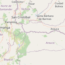
General Juan Pablo Peñaloza National Park stands out as one of Venezuela's most important high-altitude protected areas, combining exceptional páramo wilderness with critical hydrological function. The park protects the headwaters of more than a dozen rivers that collectively sustain hydroelectric power generation for western Venezuela, making it a cornerstone of regional water and energy security. The landscape features more than 130 glacial lagoons, including striking examples like Laguna Grande, Laguna Verde, and the lagoon of Bobo River, set against the dramatic backdrop of El Pulpito, the highest peak in Táchira state. The páramo ecosystem, unique to the tropical Andes, represents a globally significant biome that has evolved extraordinary adaptations to high-altitude conditions. Remaining glaciers cling to steep mountain walls, providing both scenic value and scientific insight into the region's geological and climatic history. The park's location straddling two Andean states creates opportunities for regional cooperation in conservation and sustainable development.
Best time to visit General Juan Pablo Peñaloza National Park
The best time to visit General Juan Pablo Peñaloza National Park depends on the experience sought, though the dry season from December through April typically offers more stable weather conditions for exploration of the high-altitude terrain. During these months, clearer skies provide better visibility of the dramatic mountain landscapes and lagoon views that constitute the park's most memorable scenery. The wet season from May through November brings more frequent precipitation and cloud formation, which can obscure summit views and make trail conditions more challenging. However, the wet season also brings the páramo vegetation into vibrant bloom, with espeletias and other endemic plants displaying their most spectacular flowering. Temperature conditions remain cool year-round at the park's high elevations, with daytime temperatures typically ranging from 10 to 18 degrees Celsius and nighttime temperatures frequently dropping below freezing. Visitors should prepare for rapidly changing weather conditions regardless of season, as mountain weather can shift quickly and dramatic temperature swings between day and night are normal. The park's accessibility may vary seasonally due to road conditions, particularly for vehicles attempting to reach higher-elevation trailheads.