

Mori Atlas logo
National parkGombe Stream National Park

Discover the mapped boundaries and regional geography of this East African national park.

Gombe Stream National Park: Tanzania's Protected Landscape and Geographic Atlas

Gombe Stream National Park stands as a protected national park entity within Tanzania, offering a distinct focus for geographic exploration and landscape context. This entry provides detailed atlas information on its mapped boundaries and its place within the regional geography of East Africa. Users can explore the park's identity as a protected land, contributing to a broader understanding of Tanzania's conservation landscapes and natural terrain.

Chimpanzee conservationPrimatology researchLake TanganyikaTropical forestEastern AfricaJane Goodall

Gombe Stream National Park

National park

Park overview

Structured park overview, official facts, and landscape profile for Gombe Stream National Park

Gombe Stream National Park park facts, protected area profile, and essential visitor context

Review the core facts for Gombe Stream National Park, including designation, size, terrain, visitor scale, habitats, and operating context in one park-focused overview.

About Gombe Stream National Park

Gombe Stream National Park occupies a narrow strip of mountainous terrain along the northeastern shore of Lake Tanganyika in western Tanzania. The park's landscape rises sharply from the lakeshore, with steep valleys carved by numerous small streams that flow down from the wooded ridges into the lake. This topographical complexity creates a mosaic of habitats, from lakeside shores and swampy valleys to forested slopes and ridgeline areas. The park was established in 1968, primarily to protect the chimpanzee population that Dr. Jane Goodall had been studying since 1960. Its creation marked a significant shift in Tanzanian conservation policy, as it was the first national park designated specifically to protect a primate species rather than scenic landscapes or large mammals. Access to the park is by boat from the town of Kigoma, which sits approximately 16 kilometers to the south along the lake shore. The park's small size and remote location have helped maintain its character as a focused research and conservation area rather than a major tourism destination.

Quick facts and research context for Gombe Stream National Park

Gombe Stream National Park lies in Kigoma Region of western Tanzania, bordering Lake Tanganyika to the east. The park covers approximately 52 square kilometers of terrain characterized by mountainous forest rising from the lakeshore at an elevation of around 773 meters above sea level. It was established as a national park in 1968, becoming the first of Tanzania's national parks to be created primarily for chimpanzee conservation. The park is accessible primarily by boat from Kigoma town, with regular boat services operating along the lake shore.

Park context

Deeper park guide and search-rich context for Gombe Stream National Park

Gombe Stream National Park history, landscape, wildlife, and travel context

Explore Gombe Stream National Park through its history, landscape character, ecosystems, wildlife, conservation priorities, cultural context, and seasonal travel timing in a structured park guide built for atlas discovery and search intent.

Why Gombe Stream National Park stands out

Gombe Stream is best known as the site of the world's longest-running study of wild chimpanzees, led by Dr. Jane Goodall beginning in 1960. The park's chimpanzee population, though small, has been the subject of continuous behavioral observation that has produced groundbreaking discoveries about chimpanzee tool use, hunting behavior, social organization, and cultural practices. The research transformed scientific understanding of human evolution and animal cognition, establishing Gombe as a cornerstone of primatology. Beyond chimpanzees, the park protects diverse forest ecosystems and serves as a critical conservation refuge for other primates and forest species in the Lake Tanganyika basin.

Gombe Stream National Park history and protected-area timeline

The history of Gombe Stream National Park is inseparable from the history of primatology itself. In 1960, Dr. Jane Goodall arrived at Gombe as a young British researcher to study wild chimpanzees, initially under the sponsorship of anthropologist Dr. Louis Leakey. Her groundbreaking work demonstrated that chimpanzees possessed complex behaviors previously thought unique to humans, including tool use, hunting, and sophisticated social relationships. The research station she established became known as the Gombe Stream Research Centre and produced decades of continuous data on chimpanzee behavior, genetics, and ecology. In recognition of the park's scientific importance, it was formally established as Tanzania's tenth national park in 1968. Over the subsequent decades, the park has maintained its research focus while also developing limited tourism infrastructure to support conservation funding and public education. The long-term data collected at Gombe has informed international conservation strategies for chimpanzees and contributed to the understanding of ecosystem dynamics in African forest environments.

Gombe Stream National Park landscape and geographic character

The physical landscape of Gombe Stream National Park is defined by its dramatic topographical relief and proximity to Lake Tanganyika. The park occupies a mountainous area that rises steeply from the lake shore, with elevation changes of several hundred meters occurring within relatively short distances. Numerous small streams, fed by rainfall in the highlands, cascade down through steep valleys to empty into the lake, giving the park its name. The terrain is characterized by rugged slopes, rocky outcrops, and densely vegetated valleys. The forest cover varies with elevation and aspect, with denser vegetation in the valley bottoms and more open canopy on exposed ridges. The lakeshore itself offers limited beach area, with rocky shores and steep drop-offs into the lake. This landscape of steep forested slopes surrounding the world's second-deepest lake creates a distinctive and visually striking environment that forms the habitat for the park's chimpanzee population and associated forest fauna.

Gombe Stream National Park ecosystems, habitats, and plant life

The natural environment of Gombe Stream centers on a tropical forest ecosystem that supports remarkable biodiversity despite the park's small size. The forest features a mix of evergreen and semi-deciduous tree species, with dense undergrowth in the valleys and more open understory on ridges. This heterogeneous forest structure provides diverse microhabitats for numerous species. The forest ecosystem is part of the broader Lake Tanganyika basin, which supports high levels of endemism across its terrestrial and aquatic environments. The park's streams and watercourses maintain moisture throughout the year, supporting lush vegetation in the valley systems. Beyond the forest, the lake itself represents a distinct aquatic environment with its own unique species. The combination of forest and lake habitats makes Gombe an important refuge for species in a region where forest cover has been reduced by human activity.

Gombe Stream National Park wildlife and species highlights

Gombe Stream National Park is best known for its chimpanzee population, which has been studied continuously since 1960 and represents one of the most intensively studied wild primate populations in the world. Beyond chimpanzees, the park supports other primates including red colobus monkeys, red-tailed monkeys, blue monkeys, and baboons. The forest is home to various small mammals, including several species of duiker and other forest antelopes. Birdlife is diverse, with numerous forest bird species present throughout the park. The lake shore and water provide habitat for water birds and other species associated with aquatic environments. The chimpanzee research has documented complex behaviors including tool use, cooperative hunting, territorial behavior, and social relationships that mirror aspects of human society in ways that have profoundly influenced scientific understanding of primate cognition and evolution.

Gombe Stream National Park conservation status and protection priorities

Gombe Stream National Park represents a critical conservation landmark as the first area in Tanzania established specifically to protect a primate species and their habitat. The park's long-term research program has generated invaluable data on chimpanzee behavior, population dynamics, and conservation needs, influencing international conservation strategies for great apes. The chimpanzee population at Gombe, while relatively small, has proven resilient due to the protection afforded by national park status and ongoing research presence. Conservation challenges include the fragmented nature of the forest habitat, pressure from surrounding human populations, and the need to maintain genetic connectivity with chimpanzee populations in neighboring areas. The park serves as a living laboratory demonstrating how long-term research and protected area management can support both scientific knowledge and species conservation.

Gombe Stream National Park cultural meaning and human context

Gombe Stream National Park exists within a region of rich cultural heritage along Lake Tanganyika, though the park itself is not known for specific indigenous cultural sites. The lakeshore communities have historically relied on fishing and small-scale agriculture, and the park's establishment created both opportunities and tensions with local communities. The research presence at Gombe has provided employment and educational opportunities for nearby residents, and the park contributes to the regional economy through tourism, though visitor numbers remain modest compared to Tanzania's larger parks. The international scientific legacy of the park, associated with Dr. Jane Goodall and the broader Jane Goodall Institute, has given Gombe a unique global cultural significance that extends far beyond its physical boundaries. The park's identity as the birthplace of modern primatology gives it a distinctive place in the history of science and environmental awareness.

Top sights and standout views in Gombe Stream National Park

Gombe Stream National Park offers a distinctive combination of scientific significance, primate conservation, and scenic beauty that distinguishes it from Tanzania's larger and more widely known parks. The opportunity to observe wild chimpanzees in their natural forest habitat, guided by expert researchers, provides one of the most immersive primate-watching experiences available anywhere in Africa. The park's small scale and limited visitor numbers create an intimate wilderness atmosphere quite different from the large-scale wildlife experiences of parks like Serengeti or Ngorongoro. The dramatic backdrop of steep forested slopes descending to the shores of Lake Tanganyika provides a visually striking setting. The park's role in the history of science, as the site that transformed understanding of chimpanzees and human evolution, adds a dimension of intellectual significance that enriches the visitor experience.

Best time to visit Gombe Stream National Park

The optimal time to visit Gombe Stream National Park corresponds with Tanzania's dry season, typically from May through October, when rainfall is minimal and forest trails are more accessible. During this period, chimpanzee viewing tends to be more consistent as the apes concentrate around remaining water sources in the valleys. The wet season from November through April brings more challenging trail conditions and reduced visibility in the forest, though it also offers the opportunity to see the forest at its greenest. Year-round access to the park depends on boat transport from Kigoma, and visitors should be prepared for the logistics involved in reaching this relatively remote location. The park's tropical lakeside setting means temperatures are warm throughout the year, with humidity highest during the wet season.

Monthly climate preview

Trace long-term monthly temperature averages and precipitation rhythms across the landscape.

Gombe Stream National Park Climate Normals and Annual Weather Patterns

Gombe Stream National Park exhibits measured annual temperature variations alongside distinct monthly precipitation shifts recorded across representative park coordinates. Examining the complete twelve-month climate profile reveals deeper long-term weather patterns and historical averages for this protected region.
Annual mean25 °C
24 °C27 °C
Jan24°
Feb25°
Mar25°
Apr25°
May25°
Jun24°
Jul24°
Aug26°
Sep27°
Oct26°
Nov25°
Dec24°
Warmest month
September

27 °C

Coolest month
December

24 °C

Wettest month
November

5.9 mm/day

Driest month
July

0.1 mm/day

Park location guide

Geography guide, regional context, and park location map for Gombe Stream National Park

Gombe Stream National Park park geography, regions, and map view in Tanzania

Understand where Gombe Stream National Park sits in Tanzania through a broader geographic reading of the surrounding landscape, nearby location context, and its mapped position within the national park landscape.

How Gombe Stream National Park fits into Tanzania

Tanzania, officially the United Republic of Tanzania, is a presidential republic in East Africa within the African Great Lakes region. It was formed in 1964 through the unification of Tanganyika and Zanzibar. The country is known for its diverse wildlife, national parks including Serengeti and Ngorongoro, and significant archaeological sites with important hominid fossils.

Wider geography shaping Gombe Stream National Park in Tanzania

Tanzania is located in East Africa within the African Great Lakes region. It is bordered by Uganda to the northwest, Kenya to the northeast, the Indian Ocean to the east, Mozambique and Malawi to the south, Zambia to the southwest, and Rwanda, Burundi, and the Democratic Republic of the Congo to the west. The country includes the mainland and the Zanzibar Archipelago.

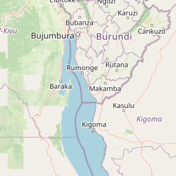
Map view of Gombe Stream National Park

Use this park location map to pinpoint Gombe Stream National Park in Tanzania, understand its exact geographic position, and read its mapped placement within the surrounding landscape more clearly.

Pigeon | © OpenStreetMap contributors
Park atlas

Geographic Context and Comparison for Protected Areas Near Gombe Stream National Park

Explore Nearby National Parks and Protected Areas around Gombe Stream National Park

Continue your exploration from Gombe Stream National Park by browsing other national parks and protected areas mapped within the broader regional geography. Compare varied conservation landscapes, trace their geographic spread, and gain a wider understanding of protected zones beyond the immediate vicinity.
National parkUvinza District
About 150 km away#1 closest

South

Mahale Mountains National Park: Tanzania's Remote Mountain Forest & Lake Tanganyika Landscape

Explore unique primate habitats and dramatic protected terrain.

Mahale Mountains National Park stands as a testament to unique ecological convergence, where the Mahale Mountains' dense forests dramatically meet the vast expanse of Lake Tanganyika. This protected area is globally recognized for harboring the largest wild population of eastern chimpanzees, offering a rare glimpse into their behavior within a pristine wilderness. The park's landscape is defined by steep mountain slopes, diverse woodland, and aquatic environments, creating a distinctive geographic context that sets it apart from typical savanna protected areas in Tanzania.

Area
1,650 km²
Established
1985
IUCN
II
Visitors
1.1K annual
National parkBurundi
About 155 km away#2 closest

Northeast

Ruvubu National Park: A National Park in Burundi Focused on Protected Landscape Geography

Explore the mapped boundaries and regional context of Ruvubu.

Investigate Ruvubu National Park, a protected natural area in Burundi, and understand its geographic significance. This page serves as a detailed atlas entry, highlighting the park's mapped extent and its contribution to the regional landscape of East Africa. Explore the protected-area context and geographical features that define Ruvubu National Park for discovery and analysis.

Area
508 km²
Established
1980
IUCN
II
Relief
Mixed relief
National parkBurundi
About 163 km away#3 closest

North

Rusizi National Park: National Park in Burundi's Geographic Landscape Context

Explore mapped protected area boundaries and regional geography.

Rusizi National Park stands as a significant protected area within Burundi, contributing to the nation's conservation atlas. This national park offers a distinct geographic profile, showcasing its specific landscape and terrain features within the East African context. Users can delve into the mapped boundaries of Rusizi National Park to understand its protected status and its role in the regional geography, facilitating detailed geographic discovery.

Area
90 km²
Established
1980
IUCN
II
Climate
Tropical
National parkBurundi
About 195 km away#4 closest

North

Kibira National Park: Burundi's Protected National Park Landscape and Geography

Mapped protected area within the Great Rift Valley region.

Kibira National Park represents a vital protected national park entity within Burundi's diverse geography. As part of the Great Rift Valley's expanse, its mapped boundaries and landscape identity offer a focal point for understanding regional protected areas. This park's presence in Burundi contributes essential data to a structured atlas of natural landscapes and conservation lands across East Africa.

Area
400 km²
IUCN
II
Relief
Mountain
Climate
Tropical
National parkRwanda
About 244 km away#5 closest

North

Nyungwe Forest National Park: Protected Landscape in Rwanda's Geography

National park mapping and regional context discovery.

Understand Nyungwe Forest National Park as a distinct protected landscape within the atlas of Rwanda. This page details its status as a national park, focusing on its geographic positioning and mapped protected boundaries. Explore the park's integral role in the regional geography of East Africa, providing a foundation for structured discovery of its natural terrain and conservation importance.

National parkRwanda
About 244 km away#6 closest

North

Nyungwe National Park: Rwanda's Protected National Park for Geographic Discovery

Explore its mapped natural landscape and protected terrain.

Nyungwe National Park represents a vital protected area within Rwanda, contributing a unique landscape to the nation's geographic atlas. This national park offers a specific focus for understanding protected lands, their mapped boundaries, and the natural terrain they encompass. By examining Nyungwe National Park, users gain insight into Rwanda's regional geography and the significance of its conservation efforts within the broader context of East African natural landscapes.

National parkSouth Kivu Province
About 254 km away#7 closest

North

Kahuzi-Biéga National Park: Protected Mountain and Rainforest Geography in South Kivu

Mapped terrain from volcanic summits to equatorial forest basins.

Kahuzi-Biéga National Park represents a significant protected area within the South Kivu Province. The geography features two distinct sectors connected by a narrow ecological corridor, encompassing everything from high-altitude subalpine heather zones to dense tropical lowland environments. This dataset provides a detailed look at the park boundaries, volcanic topography, and the regional landscape context that defines this essential habitat.

Area
6,000 km²
Established
1970
IUCN
II
Relief
Mixed relief
Nature reserveTanzania
About 257 km away#8 closest

East

Kigosi National Park Nature Reserve: Mapped Boundaries and Geographic Identity in Tanzania

Explore the protected landscape and regional context of this Tanzanian reserve.

Kigosi National Park in Tanzania is a designated nature reserve, offering a key point for exploring protected landscapes and their geographic placement. This entry details the park's identity as a conservation area, focusing on its mapped boundaries and how it fits within the regional geography of Tanzania. For users interested in atlas exploration, this provides essential context on the park's natural terrain and its standing as a protected natural area.

Area
8,265 km²
Established
2024
IUCN
II
Relief
Lowland

Common questions about visiting, size, designation, and location context for Gombe Stream National Park

Gombe Stream National Park FAQs for park facts, access, geography, and protected area context

Find quick answers about Gombe Stream National Park, including protected-area facts, park geography, trail and visitor context, and how the park fits into its surrounding country and regional landscape.
MoriAtlas Explorer

Continue Your Protected Areas Search Across the Global Atlas

Deepen your exploration by continuing the structured search for national parks and protected areas worldwide. Utilize the comprehensive filtering capabilities to compare different conservation landscapes and refine your understanding of global park geography. Discover more about the distribution and characteristics of protected natural areas.

Global natural geography

