Why Gorgona Island National Park stands out
Gorgona Island is best known for its extraordinary endemic biodiversity, particularly the blue anole (Anolis gorgonae), the only all-blue lizard species in the world. The island's dense tropical rainforest and surrounding coral reefs support a remarkable concentration of species, including numerous venomous and non-venomous snakes, marine turtles, and seasonal humpback whale populations. The park is also notable for its dramatic transformation from one of Colombia's most feared prisons to a protected natural area, a history that has given it the moniker of Colombia's Alcatraz.
Gorgona Island National Park history and protected-area timeline
The human history of Gorgona Island spans multiple centuries and encompasses indigenous settlement, colonial encounters, piracy, and one of Latin America's most notorious penal institutions. The island was first inhabited by peoples associated with the Tumaco-Tolita culture, with the Guna people traditionally considered the earliest documented settlers, leaving archaeological remains dating to approximately 1300 AD. These indigenous inhabitants were skilled sailors, farmers, and goldsmiths.
Spanish explorers first arrived in 1524, when conquistador Diego de Almagro named the island San Felipe. Three years later, Francisco Pizarro arrived during his second expedition to Peru, remaining on the island for seven months while awaiting provisions. Pizarro famously dubbed the island an "inferno" due to the numerous snakes and ultimately named it Gorgona after the mythical Medusa. The island subsequently served as a refuge for English pirates and privateers, including Bartholomew Sharp in 1679 and Woodes Rogers and William Dampier in 1709, functioning as a strategic supply station for vessels navigating between Panama and Peru.
Following Colombian independence, Simón Bolívar granted the island to military veteran Federico D'Croz. By the late 19th century, a small mestizo fishing community had established itself on the island. In 1959, the Colombian government transformed Gorgona into a high-security penal colony, housing violent criminals in facilities built to resemble Nazi concentration camps. The prison gained notorious status as Colombia's Alcatraz, with inmates living in harsh conditions and facing constant threats from snake bites and tropical diseases. The colony closed in June 1984 under President Belisario Betancur, and the island was subsequently established as Gorgona National Natural Park to protect its exceptional biodiversity.
Gorgona Island National Park landscape and geographic character
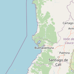
The physical landscape of Gorgona Island presents a dramatic combination of mountainous terrain, dense rainforest, and dynamic coastal environments. The island's central spine consists of a series of peaks forming the island's backbone, with Cerro La Trinidad at 338 meters representing the highest elevation. Additional named peaks include Los Micos, La Esperanza, and El Mirador, creating a mountainous interior that rises sharply from the surrounding ocean.
The eastern coastline, facing the Colombian mainland, features white sand beaches composed primarily of coral reef fragments, interspersed with rocky sections where streams debouch into the Pacific. This side of the island benefits from the island's position as the windward coast, receiving greater moisture and supporting more extensive stream systems. Approximately 25 streams flow year-round on the eastern side, with an additional 50 seasonal watercourses becoming active during the rainy season. The density of freshwater flow is exceptional, with more than ten creeks reaching the beach at La Camaronera within less than half a kilometer.
The western or oceanic side of the island presents a more rugged character, dominated by steep cliffs battered by Pacific swells and punctuated by only a couple of sandy beaches. Rock islets mark the northern tip of the island, known as Rocas del Horno, rising almost vertically from the ocean. Southwest of the main island lies the smaller Gorgonilla, separated by the 400-meter-wide Tasca strait, with additional rock islets including the prominent formation called El Viudo. The underwater topography features a 270-meter-deep depression separating the island from the continental shelf.
Gorgona Island National Park ecosystems, habitats, and plant life
The ecological character of Gorgona Island is defined by its extremely humid tropical rainforest environment and surrounding marine ecosystems, creating a biodiversity hotspot within the eastern Pacific. The island's climate features average temperatures around 26 degrees Celsius with humidity consistently near 90 percent, supporting annual rainfall exceeding 6,900 millimeters. This persistent moisture sustains a dense jungle covering the island's interior, creating conditions favorable for luxuriant plant growth and complex ecological interactions.
The surrounding marine environment encompasses fringing coral reefs along the eastern coastline and productive Pacific waters supporting diverse oceanic species. The combination of island isolation and habitat diversity has allowed speciation processes to operate over thousands of years, resulting in several species found only on Gorgona. The marine protected area extends 620 square kilometers beyond the island's shores, preserving underwater habitats and the ecological connections between terrestrial and oceanic systems.
Freshwater systems on the island are particularly well-developed, with numerous permanent streams flowing from the mountainous interior to the coast. Two inland lakes, La Cabrera and Tunapurí, add to the freshwater habitat diversity. This hydrological richness supports the island's dense vegetation and provides critical habitat for various species, particularly during the dry season when mainland water sources become limited.
Gorgona Island National Park wildlife and species highlights
Gorgona Island's wildlife is remarkable for its combination of endemic terrestrial species, diverse reptile populations, and significant marine wildlife, creating one of Colombia's most biodiverse protected areas. The island's most famous resident is the blue anole (Anolis gorgonae), a striking lizard that represents the only all-blue anole species in the world. This endemic reptile faces threats from historical habitat clearing during the prison era and predation by introduced western basilisk populations.
The island supports an exceptional diversity of snake species, including three venomous varieties: the feared Bothrops asper and two coral snake species (Micrurus dumerilii and Micrurus mipartitus). Numerous non-venomous snakes also inhabit the island, including boa constrictors, various colubrid species, and other specialized forms. This snake diversity reflects the island's long-term isolation and the evolutionary opportunities provided by a humid tropical environment.
Marine wildlife attractions include seasonal humpback whale migrations, with mothers and newborn calves visiting island waters from August through October during their southward migration. The surrounding waters host hammerhead sharks, whitetip reef sharks, sea turtles, whale sharks, and moray eels. The island has been designated an Important Bird Area by BirdLife International, supporting significant populations of brown pelicans, magnificent frigatebirds, and blue-footed boobies, with the brown booby breeding population representing the most important territory for the subspecies Sula leucogaster etesiaca globally. Terrestrial mammals include introduced Colombian white-headed capuchins, brown-throated sloths, Gorgona spiny rats, Central American agoutis, and over a dozen bat species.
Gorgona Island National Park conservation status and protection priorities
Gorgona Island National Park represents a significant conservation achievement, transforming a site of human suffering into a protected area that preserves unique biodiversity and ecosystem integrity. The park's establishment in 1984 protected an island that had remained mostly uninhabited during the prison era, allowing natural systems to persist despite nearby human activity on the mainland. The designation as IUCN Category II recognizes the park's dual mandate of protecting natural ecosystems while enabling sustainable visitor use through managed ecotourism.
The preservation of endemic species such as the blue anole remains a conservation priority, as this species faces threats from habitat fragmentation and introduced predators. The island's location in the eastern tropical Pacific positions it within a region of high marine biodiversity, and the 620-square-kilometer marine protected area safeguards critical habitats including coral reefs and pelagic environments used by migratory species. The designation as an Important Bird Area underscores the site's global significance for seabird conservation, particularly for the brown booby population representing an essential breeding territory.
Geological conservation values also contribute to the park's significance, as Gorgona hosts the youngest known komatiites on Earth, rare volcanic rocks typically associated with much older geological periods. The Cretaceous-age volcanic formations and the Cretaceous-Paleogene boundary exposures on Gorgonilla provide research opportunities that complement the site's biological importance.
Gorgona Island National Park cultural meaning and human context
The cultural context of Gorgona Island encompasses indigenous heritage, colonial history, and a modern transformation that has shaped the site's identity and visitor experience. The earliest inhabitants, associated with the Tumaco-Tolita culture and later the Guna people, left archaeological evidence of settlement dating to approximately 1300 AD, establishing human presence on the island centuries before European contact.
Spanish colonial history brought the island to wider attention through the visits of conquistadors including Diego de Almagro and Francisco Pizarro, the latter's extended stay during his Peru expedition leaving a lasting mark on the island's naming and historical record. The period of piracy in the 17th and early 18th centuries saw the island used as a refuge and supply station by English privateers, adding another layer to its complex colonial narrative.
The 20th-century prison period represents the most recent major chapter in the island's human history, transforming Gorgona into a site of incarceration and suffering that became synonymous with Colombia's criminal justice system. The closure of the prison and establishment of the national park marked a fundamental transformation in the island's relationship with Colombian society, shifting from a place of exclusion and punishment to one of environmental preservation and controlled public access. The remaining structures from the prison era, now partially reclaimed by vegetation, serve as physical reminders of this transformative history.
Top sights and standout views in Gorgona Island National Park
Gorgona Island National Park stands out as a destination where extraordinary terrestrial and marine biodiversity converges with a compelling human history. The opportunity to observe the world's only blue anole lizard represents a unique wildlife experience unavailable anywhere else on Earth. The seasonal humpback whale migration from August through October offers visitors the chance to witness mothers and newborn calves in the island's protected waters, a remarkable marine mammal spectacle in the eastern Pacific. The dense tropical rainforest, supported by annual rainfall exceeding 6,900 millimeters, creates an immersive jungle environment traversed by numerous streams and home to diverse species. The park's former life as Colombia's most notorious prison adds a distinctive historical dimension to the visitor experience, with remaining structures providing tangible connections to this unusual past.
Best time to visit Gorgona Island National Park
The best time to visit Gorgona Island depends on visitor priorities, though the park can be enjoyed year-round given its tropical climate. The period from August through October is particularly notable for humpback whale activity, as these magnificent marine mammals use the island's waters during their southward migration, with mothers and newborn calves commonly observed near the shore. The least rainy period occurs in February and March, offering more comfortable conditions for hiking and outdoor exploration, though visitors should expect rain at any time given the extremely humid climate with annual precipitation exceeding 6,900 millimeters. May and June represent the wettest months, with the island frequently enveloped in clouds and experiencing intense rainfall that enhances the lush jungle landscape but may limit some activities. Temperature remains consistently warm throughout the year, averaging around 26 degrees Celsius, with minimal variation between seasons.