Mori Atlas logo
National parkHimalaya National Park

Discover the mapped boundaries and regional landscape context of this significant protected area.

Himalaya National Park: A Protected National Park in Gilgit-Baltistan's Mountainous Geography

Himalaya National Park represents a vital protected landscape within the expansive geography of Gilgit-Baltistan, Pakistan. As a designated national park, it offers a unique lens through which to explore the region's mountainous terrain and natural boundaries. MoriAtlas provides structured insights into this protected area, helping users understand its place within the broader atlas of conservation lands and its distinct geographic identity.

high-altitude protected areaHimalayan ecosystemssnow leopard habitatmountain national parkwildlife conservationalpine meadows

Himalaya National Park

National park

Park overview

Structured park overview, official facts, and landscape profile for Himalaya National Park

Himalaya National Park park facts, protected area profile, and essential visitor context

Review the core facts for Himalaya National Park, including designation, size, terrain, visitor scale, habitats, and operating context in one park-focused overview.

About Himalaya National Park

Himalaya National Park represents a significant milestone in Pakistan's conservation framework, representing one of the most extensive contiguous high-altitude protected landscapes in the country's north. Located in the Astore District of Gilgit-Baltistan, the park was announced in December 2020 as part of the federal Protected Areas Initiative and formally notified by the Government of Gilgit-Baltistan in 2021. Covering approximately 2,263 square kilometres, the park encompasses the upper Astore Valley region, extending from near the settlements of Domail, Minimarg, and Rama northward toward the Deosai Plateau and eastward into the western Himalayan range. The park's establishment was accompanied by the creation of Nanga Parbat National Park, and together these two parks protect over 3,600 square kilometres of terrain, accounting for roughly five percent of Gilgit-Baltistan's total land area. The park is administered by the Forest, Wildlife and Environment Department of Gilgit-Baltistan under its Parks and Wildlife Circle, which manages wildlife protection, law enforcement, and ecological monitoring. The park's creation marked a major advancement in Pakistan's national biodiversity conservation framework by connecting existing reserves and expanding the country's network of high-altitude protected areas. Its rugged terrain, glacier systems, and alpine grasslands form a vital habitat corridor for endangered Himalayan species, positioning the park as a cornerstone of regional conservation efforts.

Quick facts and research context for Himalaya National Park

Himalaya National Park covers 2,263 square kilometres in the Astore District of Gilgit-Baltistan, Pakistan, at elevations between approximately 2,800 and 5,800 meters. The park was officially established in 2021 following a December 2020 announcement as part of Pakistan's Protected Areas Initiative. It is administered by the Forest, Wildlife and Environment Department of Gilgit-Baltistan and spans the upper Astore Valley near the settlements of Domail, Minimarg, and Rama. The park contributes to the Astore River basin, which flows into the Indus River. Together with the adjacent Nanga Parbat National Park, created simultaneously, these protected areas cover over 3,600 square kilometres and represent roughly five percent of Gilgit-Baltistan's total land area.

Protection and recognition

Verification of terrestrial protection scope, designation framework, and registry details

Documented Protection Status and Geographic Scope of Himalaya National Park

Reliable atlas records detail the official terrestrial protection status, designation history, and regional management scope of Himalaya National Park. Accessing verified registry data provides essential geographical context for understanding the environmental oversight and legal boundaries established for the mountain landscape.

Protection details

Protection scope
Terrestrial
Transboundary protection
No
Park context

Deeper park guide and search-rich context for Himalaya National Park

Himalaya National Park history, landscape, wildlife, and travel context

Explore Himalaya National Park through its history, landscape character, ecosystems, wildlife, conservation priorities, cultural context, and seasonal travel timing in a structured park guide built for atlas discovery and search intent.

Why Himalaya National Park stands out

Himalaya National Park is best known as a critical refuge for some of the Himalaya's most endangered species, particularly the snow leopard and Himalayan brown bear. The park protects vital habitat for the markhor, a striking wild goat with spiraling horns that is Pakistan's national animal, as well as for Himalayan ibex, blue sheep, and musk deer. Its location in the upper Astore Valley places it at the heart of one of the most ecologically significant high-altitude corridors in northern Pakistan, linking the park to neighboring Deosai National Park, Khunjerab National Park, and Central Karakoram National Park. The park's diverse habitats range from sub-alpine conifer forests through alpine scrub to high meadows, supporting an remarkable concentration of Himalayan biodiversity.

Himalaya National Park history and protected-area timeline

Himalaya National Park was established through a landmark conservation initiative announced by the Government of Pakistan on December 2, 2020. This announcement created two new national parks in Gilgit-Baltistan: Himalaya National Park and Nanga Parbat National Park, both developed as part of the Protected Areas Initiative launched to expand Pakistan's network of protected areas. The combined protected territory exceeds 3,600 square kilometres, representing approximately five percent of Gilgit-Baltistan's total land area. The Government of Gilgit-Baltistan subsequently formally notified the establishment of Himalaya National Park in 2021 through its Forest, Wildlife and Environment Department, which now oversees the park's administration and management. The creation of this park represented a significant step forward in Pakistan's commitment to biodiversity conservation, particularly for high-mountain ecosystems that face numerous environmental pressures.

Himalaya National Park landscape and geographic character

Himalaya National Park occupies a dramatic mountain landscape in the upper Astore Valley of Gilgit-Baltistan, Pakistan. The terrain is characterized by steep-walled valleys carved by ancient glaciers, expansive alpine meadows, and dense coniferous forest zones that transition into higher-elevation terrain. The park extends from near settlements including Domail, Minimarg, and Rama northward toward the Deosai Plateau and eastward into the western Himalayan range. Elevations within the park range from approximately 2,800 meters to 5,800 meters above sea level, creating a vertical profile that spans multiple ecological zones. The park's hydrological systems include numerous rivers and streams originating within its boundaries that feed into the Astore River basin, which ultimately contributes to the Indus River system. This network of glacial and snowmelt-fed waterways threading through the steep valleys forms a critical water source for downstream communities and ecosystems.

Himalaya National Park ecosystems, habitats, and plant life

The ecosystem of Himalaya National Park encompasses a remarkable diversity of habitats that support significant Himalayan biodiversity. The park's vegetation zones include sub-alpine conifer forests dominated by species adapted to the harsh mountain environment, transitioning through alpine scrub vegetation to expansive high meadows that remain snow-covered for much of the year. This vertical stratification of habitats creates optimal conditions for a range of Himalayan flora and fauna. The park provides critical habitat for several globally significant species, including the snow leopard, a secretive apex predator of high-altitude Asian mountains, and the Himalayan brown bear, a subspecies adapted to life in the alpine zone. The diverse terrain supports populations of markhor, the large wild goat with characteristic spiraling horns, along with Himalayan ibex and blue sheep. Smaller carnivores including the red fox and stone marten inhabit the park's various ecological zones, while the riparian areas and forest edges support additional mammal species.

Himalaya National Park wildlife and species highlights

Himalaya National Park provides crucial habitat for an impressive assembly of Himalayan wildlife species, particularly large mammals characteristic of the high mountains. The park is renowned as a stronghold for the snow leopard, one of the most elusive and endangered big cats in the world, which roams the steep rocky terrain and alpine zones. The Himalayan brown bear, a distinct subspecies adapted to the harsh high-altitude environment, inhabits the park's meadows and forest margins. The park supports significant populations of markhor, the impressive wild goat with spectacular spiraling horns that serves as Pakistan's national animal, as well as Himalayan ibex and blue sheep, which occupy the rocky cliff environments and alpine grasslands. Smaller mammals include the musk deer, valued for its scent-producing secretions, along with red fox and stone marten. The avifauna of the surrounding region includes the colorful Himalayan monal, the Koklass pheasant, the Himalayan griffon vulture, and the powerful golden eagle, all of which contribute to the park's ecological significance.

Himalaya National Park conservation status and protection priorities

Himalaya National Park was established specifically to conserve high-mountain ecosystems and protect threatened species that face significant survival challenges across their ranges. The park was created as part of Pakistan's national Protected Areas Initiative, reflecting the country's commitment to expanding its network of protected areas to safeguard biodiversity. The protection of the park is particularly significant for species such as the Himalayan brown bear, snow leopard, markhor, musk deer, Himalayan ibex, and blue sheep, all of which are threatened by habitat loss, poaching, and human-wildlife conflict. By connecting existing reserves including Deosai National Park, Khunjerab National Park, and Central Karakoram National Park, the park forms a vital ecological corridor that enables wildlife movement and genetic exchange between protected populations. The Forest, Wildlife and Environment Department of Gilgit-Baltistan administers the park and works to balance conservation objectives with sustainable development, including the promotion of conservation-linked tourism that can provide economic benefits to local communities while supporting habitat protection.

Himalaya National Park cultural meaning and human context

Himalaya National Park is situated in the Astore District of Gilgit-Baltistan, a region with a rich cultural heritage rooted in the traditions of the local communities who have inhabited these mountain valleys for generations. The park lies near settlements including Domail, Minimarg, and Rama, where local communities have developed close relationships with the surrounding mountain environment. The landscape has been shaped by centuries of traditional land use, including pastoral activities and seasonal migration patterns that follow the availability of grazing areas at different elevations. The region's cultural identity is closely tied to the mountains, and the establishment of the national park represents an important moment in balancing traditional uses with the need for formal conservation protections. The park's management under the Forest, Wildlife and Environment Department of Gilgit-Baltistan involves consideration of how to support local communities while achieving conservation objectives, recognizing the deep connections between people and the landscape they have inhabited.

Top sights and standout views in Himalaya National Park

Himalaya National Park stands as one of Pakistan's newest and most significant protected areas, offering protection to some of the Himalaya's most spectacular and endangered wildlife within a stunning mountain landscape. The park provides critical habitat for snow leopards and Himalayan brown bears, two of the region's most iconic species, alongside populations of markhor, ibex, and blue sheep. Its location in the upper Astore Valley places it at the crossroads of several major protected areas, creating an important ecological corridor for wildlife movement across the northern mountains. The dramatic terrain of steep valleys, glaciers, and alpine meadows, ranging from 2,800 to 5,800 meters in elevation, supports remarkable biodiversity across multiple ecological zones. As part of Pakistan's expanding protected areas network, the park represents a commitment to conserving the nation's high-altitude mountain ecosystems and the unique species they harbor.

Best time to visit Himalaya National Park

The optimal time to experience Himalaya National Park depends on the specific interests and tolerances of visitors, though the summer months from June through September generally offer the most accessible conditions for exploration. During this period, snow melt opens high-altitude routes and the alpine meadows display their full floral diversity, with wildlife being more active in the relatively warmer conditions. The monsoon season from July to August brings substantial rainfall to the region, which can affect trail conditions and visibility but also supports the lush vegetation that characterizes the park's lower elevations. Winter conditions in the park are extremely harsh, with heavy snowfall closing access to most areas and temperatures dropping well below freezing throughout the higher terrain. Spring and early summer offer excellent opportunities for wildlife observation as animals descend to lower elevations following the winter thaw, while autumn provides clear skies and the chance to witness the spectacular autumn colors transforming the coniferous forests.
Monthly climate preview

Track representative monthly temperature ranges and precipitation rhythm across high-elevation terrain.

Himalaya National Park Climate Normals and Long-Term Temperature Patterns

Representative coordinate sampling reveals significant long-term monthly temperature variations and measured precipitation cycles at high altitude in Gilgit-Baltistan. Examining the complete twelve-month record provides deeper insight into historical thermal normals and moisture distribution across the park landscape.
Annual mean-2 °C
-15 °C10 °C
Jan-15°
Feb-14°
Mar-9°
Apr-3°
May
Jun
Jul10°
Aug
Sep
Oct-1°
Nov-7°
Dec-13°
Warmest month
July

9.9 °C

Coolest month
January

-15.3 °C

Wettest month
March

2.4 mm/day

Driest month
October

0.6 mm/day

Park location guide

Geography guide, regional context, and park location map for Himalaya National Park

Himalaya National Park park geography, regions, and map view in Pakistan

Understand where Himalaya National Park sits in Pakistan through a broader geographic reading of the surrounding landscape, nearby location context, and its mapped position within the national park landscape.

How Himalaya National Park fits into Pakistan

Pakistan, officially the Islamic Republic of Pakistan, is a federal parliamentary Islamic republic in South Asia. It is the fifth-most populous country and the 33rd-largest by area. The country gained independence from British India in 1947 and has a diverse history spanning ancient civilizations including Mehrgarh and the Indus Valley Civilisation. Pakistan shares maritime borders with Oman and is bounded by the Arabian Sea, Gulf of Oman, and several neighboring countries.

Wider geography shaping Himalaya National Park in Pakistan

Pakistan is located in South Asia, bordered by the Arabian Sea to the south, the Gulf of Oman to the southwest, and shares land borders with India to the east, Afghanistan to the west, Iran to the southwest, and China to the northeast. The country also shares a maritime border with Oman in the Gulf of Oman. The Wakhan Corridor in Afghanistan separates Pakistan from Tajikistan in the northwest.

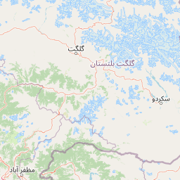
Map view of Himalaya National Park

Use this park location map to pinpoint Himalaya National Park in Pakistan, understand its exact geographic position, and read its mapped placement within the surrounding landscape more clearly.

Pigeon | © OpenStreetMap contributors

Location context for Himalaya National Park

Astore DistrictGilgit-Baltistan
Park atlas

Trace mountain protected landscapes and compare adjacent high-altitude reserves within Pakistan's Gilgit-Baltistan region.

Explore Other National Parks and Protected Areas Near Himalaya National Park

Browse a curated list of national parks and protected areas geographically connected to Himalaya National Park, revealing its placement within the vast high-altitude ecosystems of northern Pakistan. Comparing these mountain protected areas facilitates understanding of diverse wildlife habitats, regional conservation efforts, and the broader park geography across Gilgit-Baltistan.
National parkGilgit-Baltistan
About 15 km away#1 closest

Northeast

Deosai National Park: A Premier High-Altitude Alpine Wilderness and Protected Landscape in Pakistan

Mapped boundaries and unique terrain within Gilgit-Baltistan's geography.

Deosai National Park is a key protected area in Pakistan's Gilgit-Baltistan region, characterized by its high-altitude alpine meadows and expansive plateau terrain. As a national park, it offers crucial insights into mapped landscapes and regional geography, particularly for understanding conservation efforts in extreme environments. The park's setting provides a unique lens through which to explore the distribution and characteristics of protected lands within the broader atlas of natural landscapes.

Area
3,584 km²
Established
1993
IUCN
Ib
Relief
Highland
National parkPakistan
About 28 km away#2 closest

West

Gurez National Park: Pakistan's Alpine Protected Landscape and Wildlife Habitat

Explore its mapped terrain and regional geographic context.

Gurez National Park stands as a protected national park within Pakistan's breathtaking Himalayan mountain system. This park is crucial for conserving the endangered musk deer and safeguarding a fragile alpine ecosystem characterized by dramatic valleys, steep peaks, and the flowing Kishenganga River. Its relative isolation preserves a unique natural landscape and traditional cultural heritage, making it a point of interest for understanding remote wilderness and conservation efforts within the South Asian atlas.

IUCN
II
National parkGilgit-Baltistan
About 64 km away#3 closest

Northwest

Nanga Parbat National Park: Protected Himalayan Landscape and Geographic Atlas

Explore mapped boundaries and alpine terrain in Gilgit-Baltistan.

Nanga Parbat National Park is a vast protected area defined by its spectacular Himalayan setting and dramatic alpine geography within Gilgit-Baltistan, Pakistan. As a national park, it safeguards the immense Nanga Parbat massif, its surrounding glaciers, and diverse altitudinal landscapes. This page offers an atlas perspective for understanding the park's geographic scope, its mapped natural features, and its significance as a protected mountain wilderness.

Area
1,785.61 km²
Established
2021
IUCN
II
Relief
Mountain
Nature reserveJammu and Kashmir
About 67 km away#4 closest

Southwest

Wular Lake Nature Reserve: Protected Wetland and Freshwater Geography in the Kashmir Valley

Tectonic freshwater lake and Ramsar-recognized protected area.

Wular Lake stands as one of the largest freshwater bodies in South Asia, characterized by its tectonic origin and its role as a critical component of the Jhelum River catchment. The protected nature reserve landscape currently encompasses a mosaic of open water, reed beds, and muddy shallows that provide habitat for endemic snowtrout and migratory bird populations throughout the Kashmir Valley.

Established
1990
Relief
Lowland
Climate
Temperate
Scope
Terrestrial
National parkSrinagar district
About 73 km away#5 closest

South

Dachigam National Park: Protected Landscape Atlas and Geographic Context in Srinagar District

Mapped boundaries and natural terrain within India's national park system.

Gain insight into Dachigam National Park, a significant protected area located in the Srinagar district. This page provides detailed geographic context and an atlas-style view of its protected landscape. Understand its specific role as a national park and explore its mapped features, contributing to a comprehensive understanding of India's natural territories.

Area
141 km²
Established
1910
IUCN
II
Relief
Mountain
National parkJammu and Kashmir
About 83 km away#6 closest

South

Salim Ali National Park: Mapped Protected Landscape in Jammu and Kashmir

National Park with distinct geographic and regional atlas context.

Salim Ali National Park is a recognized national park situated in the Jammu and Kashmir region. This entry provides specific insights into its designation as a protected area, focusing on its mapped geographic footprint and its contribution to the regional atlas of conservation lands. Understand the park's landscape context and its place within the broader geography of northern India, offering a detailed perspective for geographic exploration.

Area
9.07 km²
Established
1986
IUCN
II
Climate
Temperate
National parkAzad Kashmir
About 84 km away#7 closest

West

Ghamot National Park: Pakistan National Park Atlas and Protected Landscape

Explore mapped boundaries and regional geography in Azad Kashmir.

Ghamot National Park represents a cornerstone for protected area exploration in Pakistan, situated within the dramatic mountainous terrain of Azad Kashmir. As a national park, it is recognized for its critical function as a wildlife corridor, especially for the survival of the Himalayan Brown Bear, and harbors diverse avian populations. This page offers detailed insight into its geographic context and its significance within a broader regional conservation strategy, providing rich data for atlas-based discovery.

Established
2004
IUCN
II
Relief
Mountain
Access
Remote access
Protected areaJammu and Kashmir
About 84 km away#8 closest

Southwest

Hokersar Protected Area: Wetland Geography and Map Context in Jammu and Kashmir

Migratory bird sanctuary and critical Jhelum basin wetland

Hokersar encompasses a distinct wetland landscape in northwestern India, characterized by shallow water, reed beds, and marshy pastures. As a key node for Palearctic waterbirds in the Kashmir Valley, the reserve provides essential flood-buffering services through its perennial stream network and seasonal snowmelt cycles, making it a focal point for regional ecological study.

Area
13.75 km²
Visitors
500K annual
Relief
Lowland
Climate
Temperate

Common questions about visiting, size, designation, and location context for Himalaya National Park

Himalaya National Park FAQs for park facts, access, geography, and protected area context

Find quick answers about Himalaya National Park, including protected-area facts, park geography, trail and visitor context, and how the park fits into its surrounding country and regional landscape.
MoriAtlas Explorer

Continue Your Protected Areas Search Across the Global Atlas

Deepen your exploration by continuing the structured search for national parks and protected areas worldwide. Utilize the comprehensive filtering capabilities to compare different conservation landscapes and refine your understanding of global park geography. Discover more about the distribution and characteristics of protected natural areas.

Global natural geography