
Mori Atlas logo
Nature reserveHohe Warte

Understanding the sandstone terrain and ecological mosaic of this protected area in Nordrhein-Westfalen

Hohe Warte Nature Reserve: Mapped Protected Landscapes of the Teutoburg Forest Edge

Hohe Warte is a distinct nature reserve located on the western edge of the Teutoburg Forest in Nordrhein-Westfalen. Defined by a characteristic sandstone hill reaching 325 meters, this protected landscape preserves a unique mosaic of inland heath and pioneer woodland. The site serves as a vital example of ecological succession on nutrient-poor soils, offering a detailed glimpse into the intersection of sandstone geography and historic land-use patterns.

nature reserveNaturschutzgebietheathlandpioneer woodlandTeutoburg Forestsandstone landscape
A graphic illustration of a mountain valley landscape with stylized pine trees in the foreground, a river flowing through the center, and a small waterfall on a rocky cliff.

Hohe Warte

Nature reserve

Park overview

Structured park overview, official facts, and landscape profile for Hohe Warte

Hohe Warte park facts, protected area profile, and essential visitor context

Review the core facts for Hohe Warte, including designation, size, terrain, visitor scale, habitats, and operating context in one park-focused overview.

About Hohe Warte

Hohe Warte sits at the transition between the wooded summit region of the Teutoburg Forest and the open countryside around Berlebeck on the outskirts of Detmold. The reserve occupies a modest sandstone hillock of about 325 meters in elevation, but its small footprint is ecologically dense and visually distinctive in the regional landscape: a mosaic of low heath, scattered pioneer trees, and stands of the forest types typical of the surrounding uplands.

The protected area was designated primarily to secure the open heath relic and the early successional woodland mosaic that has developed on historic grazing land. Its IUCN Category IV status reflects its management role as a habitat and species management area rather than a strict wilderness reserve. The Teutoburg Forest frame gives the site considerable regional context: although Hohe Warte itself is tiny, it is part of the broader pattern of small, ecologically rich protected pockets that line the edges of this central German low-mountain range.

Through the landscape plan of Detmold, the reserve has been anchored into long-term land-use policy. Half of its area belongs to the German nature conservation organization NABU, which runs the nearby Rolfscher Hof and uses intermittent grazing as a management tool. This combination of formal protection, ownership by a major conservation NGO, and active grazing makes Hohe Warte an exemplar of small-scale, partnership-based landscape conservation in the Lippe region.

Quick facts and research context for Hohe Warte

Hohe Warte is a nature reserve (Naturschutzgebiet) located in the Berlebeck district of Detmold in the German state of North Rhine-Westphalia. The protected area covers roughly six hectares, sits at around 325 meters in elevation, and lies along the edge of the Teutoburg Forest. It was first provisionally designated in 1993 and was later confirmed as a permanent nature reserve under the Detmold landscape plan in 2006, with current identification code LIP-100. The reserve is managed by the lower landscape authority of the Lippe district (Untere Landschaftsbehörde des Kreises Lippe) and is registered internationally as a Habitat/Species Management Area (IUCN Category IV).

Protection and recognition

Explore documented conservation designations and official protected area records.

Hohe Warte Protection Status and International Recognition Data

Hohe Warte features recorded protection metrics alongside official Natura 2000 recognition data. Structured conservation records provide clear insight into the management framework governing this protected natural terrain.

International recognition

Protection details

WDPA ID
555754849
Park context

Deeper park guide and search-rich context for Hohe Warte

Hohe Warte history, landscape, wildlife, and travel context

Explore Hohe Warte through its history, landscape character, ecosystems, wildlife, conservation priorities, cultural context, and seasonal travel timing in a structured park guide built for atlas discovery and search intent.

Why Hohe Warte stands out

Hohe Warte is best known for its dry, nutrient-poor sandstone habitats along the edge of the Teutoburg Forest, where open heathland of heather and blueberries blends with regenerating pioneer woodland of rowan and birch. The site is a clear-cut local example of ecological succession on a former grazing landscape that was kept open for centuries as a sheep and goat pasture.
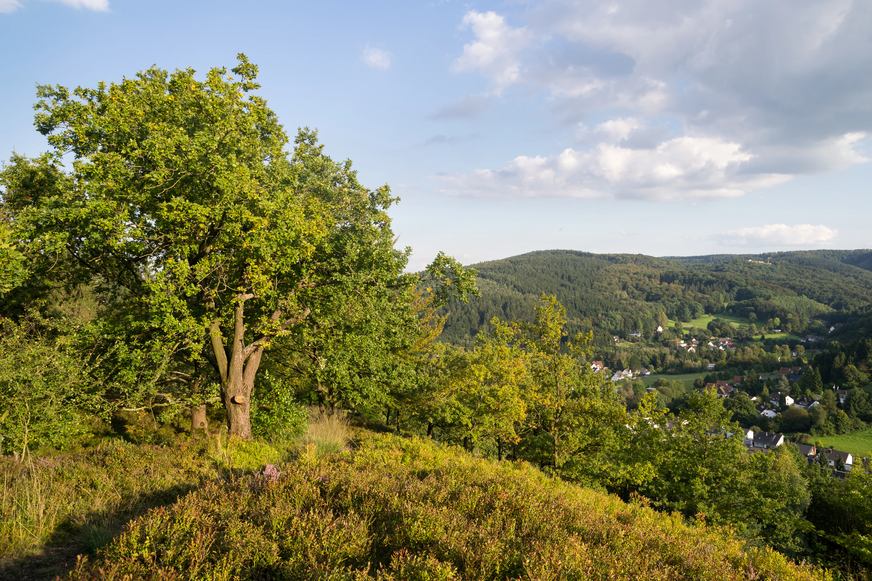
A landscape view from a hillside covered in heather and green trees, overlooking a valley with forested hills in the distance.
A scenic view over the heathland and forested slopes of the Hohe Warte nature reserve.

Hohe Warte history and protected-area timeline

The slopes of the Hohe Warte carry a long pastoral history. For centuries the land was used as a Hudefläche, an open grazing common, where sheep and goats were kept on the dry, nutrient-poor soils of the sandstone ridge. Because livestock continually browsed seedlings and trampled saplings, the hill remained largely treeless into the mid-twentieth century. Only from the 1950s onward, as grazing pressure eased, did the landscape begin to transform visibly. Heather, rowan, silver birch, and a few conifers started colonizing the formerly open land, and the old pasture gradually became a mosaic of heath and pioneer woodland.

Recognition of the site's ecological value came in 1993, when Hohe Warte was first established as a provisional nature reserve. The area was then formally confirmed as a permanent Naturschutzgebiet under the Detmold landscape plan in 2006, making it a fixed part of municipal-level conservation land use. A substantial share of the land is held by NABU, whose nearby Rolfscher Hof operates as an ecological stewardship center and uses mild, periodic grazing to slow the natural reforestation of the reserve.

Hohe Warte landscape and geographic character

The terrain of Hohe Warte is shaped by the sandstone geology of the Teutoburg Forest's western edge. The hill rises to roughly 325 meters above sea level, offering an elevated viewpoint over the adjacent Berlebeck district and the forested ridges beyond. Because the underlying rock is a relatively dry, low-fertility sandstone, the soils on the hill are thin and acidic, conditions that historically prevented closed forest from forming and that still shape the site's open, semi-exposed character today.

Visually, the reserve reads as a patchwork rather than a single continuous habitat. Pockets of low heath, with their characteristic cover of common heather and blueberry, alternate with younger stands of pioneer trees and patches of more mature mixed forest along the steeper edges. Where the sandstone outcrops and sandy pathways dominate, the ground remains bright and dry; where thin soils accumulate in slight hollows, vegetation grows taller and denser.

Hohe Warte ecosystems, habitats, and plant life

Ecologically, Hohe Warte is defined by the interaction between nutrient-poor sandstone soils and the successional recovery of a centuries-old grazing landscape. The thin, acidic substrate supports a distinctive heath plant community dominated by Besenheide (common heather) and Heidelbeere (blueberry), with the Rauschbeere (bog bilberry) appearing more occasionally in cooler microhabitats. Among the taller vegetation, pioneer species such as rowan (Eberesche) and silver birch (Sand-Birke) mark the leading edge of forest recolonization, while the more mature stands correspond to the regional forest type: a mixed community of European beech, sessile oak, and pedunculate oak, with scattered spruce, Scots pine, and larch.

The interplay between dry, open heath and encroaching woodland creates the ecological tension that defines the reserve's management strategy. Because succession would eventually close the canopy and shade out the heath flora, conservation work focuses on keeping part of the landscape permanently open. This blend of heath, pioneer woodland, and older mixed forest on a single small hill gives Hohe Warte an ecological complexity well above what its modest area might suggest.

Hohe Warte wildlife and species highlights

The fauna of Hohe Warte reflects the heath and dry-foredge character of its habitats. Grasshoppers (Heuschrecken) are conspicuous across the open heather-dominated patches, while moths (Falter) are typical of the same warm, dry, flower-rich habitat. Ground beetles (Laufkäfer) are part of the invertebrate community associated with the sandy soils and sparse ground cover. Ant colonies add to the invertebrate profile of the reserve.

Although the source material does not emphasize larger vertebrates, the surrounding Teutoburg Forest context and the mix of open heath and woodland make the reserve a plausible local habitat for typical central German forest and heath species, including common woodland birds and small mammals. The documentable wildlife signal, however, rests primarily on its invertebrate communities tied directly to the heath and pioneer-woodland mosaic.

Hohe Warte conservation status and protection priorities

Hohe Warte is protected as a permanent nature reserve under the Detmold landscape plan, with international recognition as a Habitat/Species Management Area (IUCN Category IV). Its conservation purpose is the long-term preservation of a rare local heath ecosystem on nutrient-poor sandstone soils, together with the early successional woodland mosaic that has developed alongside it.

Conservation value is enhanced by the NABU's ownership of roughly half of the reserve and its operation of the nearby Rolfscher Hof as an ecological stewardship base. Active management through intermittent grazing deliberately slows the natural shift from open heath back to closed forest, maintaining the very habitat pattern that the reserve was created to protect. In this sense Hohe Warte represents a small but well-integrated example of partnership-based nature conservation in the Lippe district, combining statutory protection with NGO land ownership and on-the-ground management.

Hohe Warte cultural meaning and human context

Most of the cultural meaning of Hohe Warte comes from its long role as an open grazing commons in the Detmold countryside. The hill's name itself, meaning roughly 'high guard' or 'high lookout,' evokes its position above the surrounding terrain, but historically its openness was the more defining trait. As an Hudefläche used by local shepherds, the landscape sat at the interface of village agricultural life and the larger Teutoburg Forest, a relationship that ended only in the mid-twentieth century when traditional grazing pressure eased.

The modern cultural framing of the site is shaped by NABU's stewardship activities around the Rolfscher Hof, where ecological education, hedgerow management, and traditional grazing practices are blended. This gives Hohe Warte a quiet but recognizable identity as a place where the older rural land-use traditions of the Lippe region have been folded into modern nature conservation practice.

Top sights and standout views in Hohe Warte

Hohe Warte's main strength lies in how much ecological variety is packed into a very small area at the edge of the Teutoburg Forest. The reserve offers a textbook example of heath and pioneer woodland mosaic on nutrient-poor sandstone.

Equally notable is the conservation partnership around the site: half of the area is owned by NABU, the reserve is anchored under a formal landscape plan, and ongoing grazing keeps the open heath alive against natural reforestation. This combination of statutory protection, NGO ownership, and active management distinguishes it from many similarly sized reserves in the region.

Best time to visit Hohe Warte

Because Hohe Warte is a small heath-and-woodland reserve rather than a high-altitude or strongly seasonal destination, its character shifts mainly with the flowering of the heathland and the visibility of the surrounding Teutoburg Forest. Late summer and early autumn are traditionally the most expressive season for the Besenheide and Heidelbeere communities that dominate the open ground, when the heather comes into bloom and the hill's panoramic position over Berlebeck is most legible from its open patches.

Spring is also rewarding for observing the contrast between fresh pioneer tree growth and the still-bare heath floor, while winter offers clearer sightlines through the deciduous parts of the reserve. In all seasons, the small size of the area means visits tend to be short and contemplative rather than extended excursions.

Monthly climate preview

Long-term representative averages tracking monthly temperature and precipitation rhythm

Hohe Warte Climate Normals and Measured Annual Temperature Patterns

Representative coordinate measurements for Hohe Warte outline a measured annual temperature range from sub-zero winter minimums to warm summer maximums alongside steady monthly precipitation. Examining the complete twelve-month climatology dataset reveals broader seasonal norms across the protected terrain.
Annual mean9 °C
1 °C18 °C
Jan
Feb
Mar
Apr
May13°
Jun16°
Jul18°
Aug18°
Sep14°
Oct
Nov
Dec
Warmest month
July

18.1 °C

Coolest month
January

0.5 °C

Wettest month
December

2.6 mm/day

Driest month
April

1.6 mm/day

Park location guide

Geography guide, regional context, and park location map for Hohe Warte

Hohe Warte park geography, regions, and map view in Germany

Understand where Hohe Warte sits in Germany through a broader geographic reading of the surrounding landscape, nearby location context, and its mapped position within the national park landscape.

How Hohe Warte fits into Germany

Germany is a federal republic in Western and Central Europe with a population of over 83 million across sixteen constituent states. It is Europe's largest economy by nominal GDP and a major global exporter and importer. The capital is Berlin, and the country borders Denmark, Poland, Czech Republic, Austria, Switzerland, France, Luxembourg, Belgium, and the Netherlands.

Wider geography shaping Hohe Warte in Germany

Germany is located in Western and Central Europe, spanning 357,022 km². It borders Denmark to the north, Poland and the Czech Republic to the east, Austria and Switzerland to the south, and France, Luxembourg, Belgium, and the Netherlands to the west. The country has coastlines on the Baltic Sea and North Sea to the north, with the Alps located in the southern region.

Map view of Hohe Warte

Use this park location map to pinpoint Hohe Warte in Germany, understand its exact geographic position, and read its mapped placement within the surrounding landscape more clearly.

Pigeon | © OpenStreetMap contributors

Location context for Hohe Warte

Nordrhein-Westfalen

Explore photographic records of sandstone ridges, open heath mosaics, and pioneer woodland habitats

Hohe Warte Photos and Scenery: Visualizing the Teutoburg Forest Protected Landscape

Visual documentation captures the distinct sandstone terrain, open heather patches, and regenerating woodland mosaic defining the Hohe Warte protected area. Examining field photography helps reveal how ecological succession and conservation grazing shape the topography of the western Teutoburg Forest.

A landscape view from a hillside covered in heather and green trees, overlooking a valley with forested hills in the distance.

Park atlas

Compare nearby protected areas and regional reserves across the Teutoburg Forest

Explore Parks Near Hohe Warte and Connected Protected Landscapes in the Region

Discover nearby national parks and protected areas sharing the same sandstone terrain and forest edge geography as Hohe Warte. Broadening your search helps connect isolated heathland reserves with the wider ecological mosaic of North Rhine-Westphalia.
Nature reserveNorth Rhine-Westphalia
About 7.6 km away#1 closest

Southeast

Hohlsteinhöhle Nature Reserve: Karst Geography and Subterranean Habitat Maps in North Rhine-Westphalia

Protected limestone fissure caves in the Eggegebirge range

Hohlsteinhöhle stands as a significant protected site within the northern Eggegebirge uplands. Known for its distinct Upper Cretaceous marl-limestone fissures and role as a crucial winter refuge for sensitive bat species, this nature reserve offers a detailed look at the karst-driven geological character of the region, emphasizing the conservation of restricted subterranean environments.

Relief
Mountain
Climate
Temperate
Access
Highly restricted
Scope
Terrestrial
A soft watercolor illustration featuring rolling green hills, a small grouping of trees on the right, and open grassy terrain on a white background.
Protected areaNordrhein-Westfalen
About 9.1 km away#2 closest

Southwest

Senne mit Teutoburger Wald: Protected Habitat and Regional Geography Atlas

Heathland and forest ecosystems in North Rhine-Westphalia

This protected area presents a unique geographic profile, merging expansive lowland heath and dune systems with the wooded slopes of the Teutoburg Forest. Its distinct ecological gradient and significant size make it a critical site for habitat conservation, bird protection, and study of transition zones between sandy plains and mountain ridges.

Area
153.597 km²
Established
2001
Relief
Mixed relief
Climate
Temperate
A soft watercolor painting of a river flowing through a gentle green valley with scattered trees and a small stone bridge, set against a pale yellow and pink sky.
Nature reserveNordrhein-Westfalen
About 13 km away#3 closest

Northeast

Marpetal mit Passade und Zufluesse: Nature Reserve and Stream Valley Geography

Protected riparian landscapes in the district of Lippe

Marpetal mit Passade und Zufluesse consists of an 89-hectare nature reserve that safeguards the ecological integrity of small river valleys. Its terrain, defined by the Passade and Marpe streams, connects with adjacent protected lands to maintain a continuous corridor of floodplain and slope habitats within the rural Westphalian landscape.

Area
0.889 km²
Established
2005
A horizontal watercolor painting depicting a soft-toned landscape with scattered evergreen trees and undulating, sandy terrain under a light sky.
Nature reserveNordrhein-Westfalen
About 14 km away#4 closest

West

Moosheide Nature Reserve: Mapping the Ancient Inland Dune Landscapes of Nordrhein-Westfalen

Protected heathland and spring-fed habitat geography.

Moosheide provides a focused look at the geomorphology of the western Senne region. This reserve protects some of the oldest inland dunes in northwestern Germany, alongside a rare juxtaposition of dry sandy grasslands and groundwater-dependent stream valleys that support high species diversity.

Area
4.427 km²
Established
1994
IUCN
IV
Relief
Lowland
A watercolor painting of a wetland landscape with soft green hills, trees, and a winding waterway.
Nature reserveNorth Rhine-Westphalia
About 16 km away#5 closest

West

Kipshagener Teiche Nature Reserve: A Protected Wetland Sanctuary in North Rhine-Westphalia

Geographic analysis of historic bogs and managed wetland habitats

Kipshagener Teiche is a small but essential nature reserve in the Senne region, characterized by a distinct mosaic of ponds, transitional bog, and wet heath. Originally protected in 1937, the site serves as a vital record of wetland biodiversity and recovery in western Germany. Its varied topography, featuring dune-based pine plantations and swamp forest, offers a precise look at the intersection of conservation and landscape management in a human-influenced region.

Area
0.113 km²
Established
1970
IUCN
IV
A watercolor painting showing a stylized landscape with rolling green hills, a winding path or stream, and distant purple mountains against a white background.
Nature reserveNorth Rhine-Westphalia
About 16 km away#6 closest

North

Ilse Nature Reserve: Protected Stream Corridor and Floodplain Geography in North Rhine-Westphalia

Mapped riparian habitats and regional conservation landscape context.

Ilse Nature Reserve serves as a critical protected corridor within the Lippe district, spanning five distinct sections along the Ilse stream. The reserve is defined by its near-natural watercourse, wet meadows, and traditional orchard remnants that safeguard species-rich habitats. This geographic focus provides essential insights into the conservation of lowland stream ecosystems and their role in maintaining the ecological connectivity of the broader Bega river valley.

Area
0.142 km²
Established
2009
IUCN
IV
Relief
Upland
Nature reserveNordrhein-Westfalen
About 16 km away#7 closest

Southwest

Lippeniederung zwischen Bad Lippspringe und Mastbruch: A Protected Floodplain Landscape

Nature reserve geography and river valley conservation in Paderborn, Germany.

Lippeniederung zwischen Bad Lippspringe und Mastbruch encompasses a specialized floodplain corridor along the Lippe river. This site highlights the importance of managing small-scale riverine meadows and aquatic transition zones within the broader, heavily used agricultural geography of North Rhine-Westphalia.

Area
1.59 km²
Established
1966
IUCN
IV
Relief
Lowland
A pale, soft-toned watercolor painting of a rolling landscape with green fields, forested areas, and a small winding stream under a light sky.
Nature reserveNordrhein-Westfalen
About 17 km away#8 closest

Northwest

Holzhauser Bruch Nature Reserve: Protected Wetland and Riparian Geography in Nordrhein-Westfalen

Mapping lowland bog and meandering river corridors

Holzhauser Bruch in Nordrhein-Westfalen preserves a compact yet ecologically vital riverine landscape. Its terrain contrasts wet alder-dominated swamp forests with drier, sandy upland slopes. This summary explores the geographic boundary of the reserve, highlighting its role as a representative fragment of the Werre valley habitat system.

Area
0.4 km²
Established
2002

Common questions about visiting, size, designation, and location context for Hohe Warte

Hohe Warte FAQs for park facts, access, geography, and protected area context

Find quick answers about Hohe Warte, including protected-area facts, park geography, trail and visitor context, and how the park fits into its surrounding country and regional landscape.
MoriAtlas Explorer

Continue Your Protected Areas Search Across the Global Atlas

Deepen your exploration by continuing the structured search for national parks and protected areas worldwide. Utilize the comprehensive filtering capabilities to compare different conservation landscapes and refine your understanding of global park geography. Discover more about the distribution and characteristics of protected natural areas.

Global natural geography