

Mori Atlas logo
National parkHwange National Park

Explore the mapped geographic boundaries and natural terrain of this national park.

Hwange National Park: A Protected Landscape in Matabeleland North, Zimbabwe

Hwange National Park stands as a significant protected area within the Matabeleland North region of Zimbabwe. This page offers an in-depth look at its protected landscape, providing detailed insights into its mapped boundaries and the broader regional geography it occupies. Users can explore Hwange National Park as a distinct entity, understanding its role and geographic character within the national park atlas.

national parkbig fiveelephant populationCape wild dogKalahari ecosystemsafari destination

Hwange National Park

National park

Park overview

Structured park overview, official facts, and landscape profile for Hwange National Park

Hwange National Park park facts, protected area profile, and essential visitor context

Review the core facts for Hwange National Park, including designation, size, terrain, visitor scale, habitats, and operating context in one park-focused overview.

About Hwange National Park

Hwange National Park occupies a vast tract of semi-arid wilderness in northwestern Zimbabwe, representing the country's largest and most ecologically diverse protected area. The park's landscape sits at the transition between the Kalahari desert to the west and the more typical savanna ecosystems of southern Africa, creating a unique blend of habitats that support exceptional biodiversity. The park is underlain primarily by Kalahari Sands, with basalt lava flows in the northwest and granite-gneiss formations in the north-central region. While no permanent rivers traverse most of the park, a network of seasonal wetlands, grassy pan depressions, and artificially pumped waterholes provides crucial water sources for wildlife throughout the year. The park's vegetation reflects this environmental transition, with Kalahari woodland dominated by Zambezi Teak, Sand Camwood, and Kalahari bauhinia in the south and east, giving way to denser mopane woodland in the north and northwest. These varied habitats support over 100 mammal species and more than 400 bird species, making Hwange one of Africa's most wildlife-rich protected areas. The park's proximity to Victoria Falls and Bulawayo makes it accessible to visitors while retaining a remote wilderness character that distinguishes it from more heavily developed safari destinations.

Quick facts and research context for Hwange National Park

Hwange National Park covers roughly 14,600 square kilometers in Matabeleland North, Zimbabwe, making it the country's largest protected area. The park lies at the transition between the Kalahari desert ecosystem and more typical southern African savanna woodland, with vegetation ranging from Zambezi Teak forest to mopane woodland and seasonal grasslands. It hosts over 100 mammal species including elephants, lions, leopards, cheetahs, and one of Africa's largest remaining populations of Cape wild dogs. All of Zimbabwe's specially protected animal species are found within the park, and it serves as a Lion Conservation Unit recognized alongside the Okavango Delta and Kruger National Park.

Protection and recognition

Verifying the official designation timeline and terrestrial conservation scope established in 1961.

Hwange National Park Protection Status and Conservation Designation

Researchers can examine the documented protection status and terrestrial conservation framework established for Hwange National Park. Analyzing the official 1961 designation history provides critical geographic context for mapping protected terrestrial landscapes in Southern Africa.

Protection details

Protection scope
Terrestrial
Designated year
1961
Transboundary protection
No
Park context

Deeper park guide and search-rich context for Hwange National Park

Hwange National Park history, landscape, wildlife, and travel context

Explore Hwange National Park through its history, landscape character, ecosystems, wildlife, conservation priorities, cultural context, and seasonal travel timing in a structured park guide built for atlas discovery and search intent.

Why Hwange National Park stands out

Hwange is best known for its extraordinary elephant populations, which have grown to densities far beyond the land's natural carrying capacity, creating ongoing ecological management challenges. The park is also famous for its Cape wild dog packs, representing one of the largest surviving populations of this endangered canid in Africa. Its position at the Kalahari desert edge creates a distinctive environment where desert-adapted species like gemsbok and brown hyena occur alongside typical savanna wildlife. The park's network of artificial waterholes and natural pans provides reliable wildlife viewing opportunities, particularly during the dry season when animals congregate around these water sources. The 2015 killing of Cecil the lion brought international attention to the park, highlighting both its wildlife value and the complexities of hunting and conservation in Zimbabwe.

Hwange National Park history and protected-area timeline

Hwange National Park was established in 1928 as the Wankie Game Reserve, originally encompassing a smaller area than the present park. The reserve was upgraded to national park status in 1961, formalizing its protection under Zimbabwe's wildlife management framework. The park has been considered for inclusion in the Kavango-Zambezi Transfrontier Conservation Area, a five-nation initiative that would connect protected areas across southern Africa. The park has faced significant challenges from poaching, particularly the 2011 incident in which poachers killed nine elephants, five lions, and two buffaloes. The most notorious poaching event occurred in October 2013 when poachers poisoned waterholes with cyanide, killing at least 103 elephants in what conservationists described as the largest illegal killing of animals in Southern Africa in 25 years. Three poachers were subsequently arrested, tried, and convicted, and Zimbabwe implemented mandatory nine-year sentences for royal game and elephant poaching offenses. The park also became internationally known following the 2015 killing of Cecil, a lion that had lived in the park for 13 years, by American dentist Walter Palmer. Two years later, Cecil's son Xanda was killed in a similar incident, sparking continued debate about big game hunting in Zimbabwe.

Hwange National Park landscape and geographic character

The landscape of Hwange National Park reflects its position at the edge of the Kalahari desert, characterized by vast expanses of semi-arid woodland and grassland punctuated by seasonal wetlands. The park's underlying geology consists primarily of Kalahari Sands, which create generally flat to gently undulating terrain across most of the reserve. In the northwest, basalt lava flows from the Batoka Formation extend from south of Bumbusi toward the Botswana border, while the north-central area around Sinamatella contains granite and gneiss formations of the Kamativi-Dete Inlier. The northern and northwestern regions are drained by the Deka and Lukosi river systems, while the far south drains into the Gwabadzabuya River, a tributary of the Nata River. Most of the park lacks permanent surface water, instead relying on a network of fossil drainage channels that form seasonal vleis and grassy pan depressions. Some pans, like those in the Shumba area, fill only with rainwater, while others such as Ngweshla, Shakwanki, and Nehimba are fed by natural groundwater seeps. Many additional pans are supplied by water pumped from underground by park authorities, creating artificial waterholes that have become crucial wildlife attractions.

Hwange National Park ecosystems, habitats, and plant life

The ecological character of Hwange reflects its transitional position between desert and savanna ecosystems, creating a unique blend of habitats supporting remarkable biodiversity. The park's vegetation ranges from Kalahari woodland dominated by Zambezi Teak, Sand Camwood, and Kalahari bauhinia in the south and east, to denser mopane woodland in the north and northwest. Seasonal wetlands form grasslands in low-lying areas, providing important dry-season grazing for large herbivores. Although some researchers have raised concerns about elephant impacts on vegetation structure, recent studies suggest that the park's vegetation has remained relatively stable despite significant increases in elephant populations since the late 1980s. The park's waterhole network, both natural and artificially maintained, creates ecological gradients that influence wildlife distribution, with grazing herbivores more common in the Main Camp Wild Area and Linkwasha Concession Area, while mixed feeders dominate the more heavily wooded Robins and Sinamatella Wild Areas.

Hwange National Park wildlife and species highlights

Hwange National Park hosts exceptional wildlife diversity, with over 100 mammal species and more than 400 bird species recorded within its boundaries. The park contains 19 large herbivore species and eight large carnivore species, representing the full spectrum of Zimbabwe's specially protected animals. The African bush elephant population has flourished extraordinarily, growing to densities far exceeding what the land naturally supports and creating ongoing management challenges. The park supports one of Africa's largest remaining populations of Cape wild dogs, a species that has declined dramatically across its range, along with healthy populations of lions, leopards, spotted hyenas, and cheetahs. Hwange is the only protected area in Zimbabwe where gemsbok and brown hyena occur in small numbers, reflecting the park's position at the edge of the Kalahari desert. Large herbivore distribution fluctuates seasonally, with animals concentrating around areas where intensive water pumping is maintained during the dry season. Notable bird species include the southern ground hornbill, martial eagle, kori bustard, and numerous raptors and waterbirds.

Hwange National Park conservation status and protection priorities

Hwange National Park holds significant conservation importance as Zimbabwe's largest protected area and a key component of the country's wildlife estate. The park is designated as an IUCN Category II protected area and serves as a Lion Conservation Unit, recognized alongside the Okavango Delta and Kruger National Park for its role in maintaining viable lion populations. The park's Cape wild dog population represents one of the largest remaining groups in Africa, making it crucial for the conservation of this endangered species. The National Leopard Project operates in Hwange in partnership with Oxford University's Wildlife Conservation and Research Unit and the Dete Animal Rescue Trust, conducting surveys to establish baseline population data. The Painted Dog Project, operated by the Painted Dog Conservation organisation based in Dete, works to protect and expand African wild dog populations both in Zimbabwe and across Africa. The park has faced significant conservation challenges from poaching, particularly the 2013 cyanide poisoning incident that killed over 100 elephants, prompting strengthened penalties including mandatory nine-year sentences for elephant poaching.

Hwange National Park cultural meaning and human context

Human presence in the Hwange region spans tens of thousands of years, as evidenced by numerous archaeological sites throughout the park ranging from the early Stone Age to the historic era. Stone-age foragers hunted and gathered in the area, leaving behind numerous stone tool sites throughout what is now the park. These ancient inhabitants created rock engravings depicting animal hoofprints on sandstone rockshelter walls, along with some small rock paintings in the park's northwest. Iron-age peoples built both large and small stone-walling sites within the park, including significant locations at Mtoa and the Bumbusi National Monument. These archaeological resources demonstrate the long human history of interaction with this landscape, though the park's primary identity today is focused on wildlife conservation rather than ongoing cultural use.

Top sights and standout views in Hwange National Park

Hwange National Park offers exceptional wildlife viewing at one of Africa's largest protected areas, with reliable elephant sightings around the park's network of artificial waterholes. The Cape wild dog packs represent one of the best opportunities in Africa to observe this endangered species in the wild. The park's position at the Kalahari desert edge provides a distinctive environment where visitors can see desert-adapted species like gemsbok alongside typical savanna wildlife. The landscape of vast woodland, seasonal vleis, and scattered pans creates a visually striking wilderness that differs from more mountainous or river-based African parks. Archaeological sites including Stone Age rock art and Iron Age stone-walling sites add cultural depth to the wildlife experience.

Best time to visit Hwange National Park

The optimal time to visit Hwange National Park is during the dry season from April to October, when wildlife congregates around the limited water sources and vegetation is less dense, improving visibility. The peak dry season months of September and October offer the best wildlife viewing as animals become increasingly concentrated around waterholes. The wet season from November to March brings green scenery and excellent birdwatching as migratory species arrive, though wildlife is more dispersed across the landscape. The park remains accessible year-round, though some roads may become difficult during the peak of the wet season. Visitors seeking to avoid peak visitor numbers might consider traveling during the shoulder months of April or October, which offer good wildlife viewing with fewer crowds.

Monthly climate preview

Long-term representative monthly temperature and precipitation rhythm

Hwange National Park Climate Normals and Annual Weather Patterns

Representative coordinate records show measured variations in average temperature and precipitation across twelve monthly cycles for Hwange National Park. Examining the complete monthly climate normals profile provides detailed long-term averages for sustained regional geography analysis.
Annual mean23 °C
17 °C27 °C
Jan25°
Feb25°
Mar24°
Apr23°
May20°
Jun17°
Jul17°
Aug20°
Sep24°
Oct27°
Nov27°
Dec26°
Warmest month
October

27.3 °C

Coolest month
July

16.8 °C

Wettest month
January

4.8 mm/day

Driest month
August

0 mm/day

Park location guide

Geography guide, regional context, and park location map for Hwange National Park

Hwange National Park park geography, regions, and map view in Zimbabwe

Understand where Hwange National Park sits in Zimbabwe through a broader geographic reading of the surrounding landscape, nearby location context, and its mapped position within the national park landscape.

How Hwange National Park fits into Zimbabwe

Zimbabwe is a landlocked nation in Southeast Africa located between the Zambezi and Limpopo rivers. The country has a population of roughly 17 million people and uses English, Shona, and Ndebele as its primary languages. Once the site of the ancient Kingdom of Zimbabwe and the city of Great Zimbabwe, it gained independence from the United Kingdom in 1980.

Wider geography shaping Hwange National Park in Zimbabwe

Zimbabwe is located in Southeast Africa between the Zambezi River to the north and the Limpopo River to the south. It is landlocked, bordered by South Africa, Botswana, Zambia, and Mozambique. The terrain includes highlands, savanna, and the Zambezi valley.

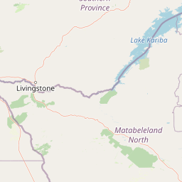
Map view of Hwange National Park

Use this park location map to pinpoint Hwange National Park in Zimbabwe, understand its exact geographic position, and read its mapped placement within the surrounding landscape more clearly.

Pigeon | © OpenStreetMap contributors

Location context for Hwange National Park

Matabeleland North
Recorded earthquake history

View Historical Earthquake Records and Seismic Data for Hwange National Park

Access the MoriAtlas catalogue of recorded seismic events near Hwange National Park. Review historical data, including event dates, magnitudes, and proximity to this protected landscape to build a clearer understanding of the regional geological context.

Hwange National Park Earthquake History

Catalogued events

4 events

Strongest magnitude

Magnitude 4.7

Most recent event

Mar 15, 2008

This history includes earthquakes recorded inside the park or within 50 km of its borders

Park atlas

Compare Protected Areas Near Hwange National Park: Regional Geography and Connected Conservation Landscapes

Explore Nearby National Parks and Protected Areas Beyond Hwange National Park, Tracing Regional Conservation Landscapes

After exploring Hwange National Park, browse nearby national parks and protected areas within Zimbabwe and across adjacent Southern African landscapes. Examining mapped geographies reveals the broader spread of conservation efforts, distinct regional ecosystems, and diverse wildlife habitats, offering deep insights into interconnected protected lands.
National parkZimbabwe
About 29 km away#1 closest

Northwest

Kazuma Pan National Park: Zimbabwe National Park Atlas and Protected Landscape Exploration

Unique plains landscape with reliable dry-season wildlife viewing.

Kazuma Pan National Park offers a rare glimpse into Zimbabwe's expansive grassy plains and vital pans, creating a unique protected landscape. This national park is critical for understanding regional wildlife migrations and the geographic context of conservation areas in northwestern Zimbabwe, providing an essential entry point for atlas-based exploration of its terrain and ecological significance.

Area
313 km²
Established
1975
IUCN
II
Relief
Lowland
National parkZimbabwe
61 km away#2 closest

Northwest

Victoria Falls National Park: A Protected Landscape Within Zimbabwe's Geography

Atlas exploration of park boundaries and natural terrain.

Victoria Falls National Park is a key component of Zimbabwe's protected natural areas. This page provides structured information ideal for atlas-based exploration, detailing the park's geographic position and mapped landscape features. Understand its significance as a national park and its contribution to the region's conservation geography.

Area
23.4 km²
IUCN
II
Relief
Mixed relief
Climate
Tropical
National parkBotswana
64 km away#3 closest

West

Chobe National Park: Botswana National Park Atlas and Mapped Landscape Explorer

Discover Botswana's diverse protected areas and unique savanna wetlands.

Chobe National Park represents a cornerstone of protected land discovery in Botswana, offering an unparalleled glimpse into a landscape shaped by dynamic water systems and iconic wildlife. This national park is not merely a destination; it is a vital ecosystem supporting vast elephant populations and showcasing a remarkable variety of terrain from riverine floodplains to savanna marshes. Understanding Chobe National Park through its mapped boundaries and regional geographic context reveals its significance as a protected natural area with diverse habitats supporting critical conservation efforts.

Area
11,700 km²
Established
1967
IUCN
II
Relief
Mixed relief
National parkSouthern Province
About 76 km away#4 closest

Northwest

Mosi-oa-Tunya National Park: National Park Exploration and Geographic Atlas

Mapped boundaries and protected landscape context in Southern Province, Zambia.

Gain a comprehensive understanding of Mosi-oa-Tunya National Park, a designated national park in Zambia's Southern Province. This entry focuses on its protected area identity, mapped geographic scope, and its position within the regional atlas. Discover the essential landscape context and the structured geographic information that defines this important conservation area, providing a factual foundation for atlas-based exploration.

Area
66 km²
IUCN
II
Climate
Subtropical
Access
Easy access
National parkHwange District
About 78 km away#5 closest

Northwest

Zambezi National Park: National Park within Hwange District's Geographic Landscape

Explore mapped boundaries and protected area context.

Delve into Zambezi National Park, a designated national park situated in Hwange District. This entry provides foundational geographic and landscape context, highlighting the park's protected status and its position within the regional terrain. Understand the atlas significance and mapped features of this conservation landscape for informed discovery.

Area
560 km²
Established
1979
Relief
Lowland
Climate
Subtropical
National parkBotswana
112 km away#6 closest

Southwest

Nxai Pan National Park: Botswana's Iconic Baobab Forests and Salt Pan Landscape

Explore mapped boundaries and unique regional geography.

Nxai Pan National Park offers a compelling glimpse into Botswana's unique semi-arid ecosystems, characterized by the expansive, salt-crusted Nxai Pan itself and the iconic Baines Baobabs dotting its edges. As a protected national park, it represents a significant conservation landscape within the Kalahari Desert region. Understanding its geography involves appreciating the stark visual contrasts, seasonal wetland transformations, and the vast openness of the salt pan environment.

Area
2,578 km²
Established
1992
IUCN
Ib
Relief
Lowland
National parkZimbabwe
About 163 km away#7 closest

Northeast

Chizarira National Park: Zimbabwe's Remote Protected Landscape on the Zambezi Escarpment

Explore rugged mountains, deep gorges, and unique woodland ecosystems.

Chizarira National Park offers an unparalleled exploration of wilderness and dramatic geography within Zimbabwe. Situated along the imposing Zambezi Escarpment, its landscape is characterized by a 600-meter drop, rugged mountains, and deep river gorges carved by perennial streams. This protected area, known for its remote appeal and rich leopard populations, provides a distinct view of miombo and mopane woodlands, contributing to its unique ecological identity within the regional geography.

Area
2,000 km²
Established
1975
IUCN
II
Relief
Mountain
National parkBotswana
About 163 km away#8 closest

Southwest

Makgadikgadi Pans National Park: A Protected Landscape in Botswana's Geographic Atlas

Explore its mapped boundaries and regional natural terrain.

Makgadikgadi Pans National Park is a designated national park in Botswana, contributing significantly to the region's atlas of protected lands. This page details its geographic scope, emphasizing its role as a mapped natural landscape within Southern Africa. Explore the park's unique protected-area identity and understand its place within Botswana's diverse, largely Kalahari Desert-influenced terrain.

Relief
Lowland
Climate
Arid
Scope
Terrestrial
Water
Major water bodies

Common questions about visiting, size, designation, and location context for Hwange National Park

Hwange National Park FAQs for park facts, access, geography, and protected area context

Find quick answers about Hwange National Park, including protected-area facts, park geography, trail and visitor context, and how the park fits into its surrounding country and regional landscape.
MoriAtlas Explorer

Continue Your Protected Areas Search Across the Global Atlas

Deepen your exploration by continuing the structured search for national parks and protected areas worldwide. Utilize the comprehensive filtering capabilities to compare different conservation landscapes and refine your understanding of global park geography. Discover more about the distribution and characteristics of protected natural areas.

Global natural geography
