Why Ichigkat Muja, Cordillera del Condor National Park stands out
The park is best known for protecting the cloud forests and montane forests of the Cordillera del Condor, a biodiversity-rich mountain range in the northern Peruvian Andes. It safeguards the transition zone between Amazonian lowland forests and high-elevation Andean ecosystems, supporting a remarkable diversity of flora and fauna across its altitudinal gradient. The area is particularly notable for its populations of Andean cock-of-the-rock, jaguar, and other iconic species of the Eastern Cordillera Real ecoregion.
Ichigkat Muja, Cordillera del Condor National Park history and protected-area timeline
The park was officially established on August 10, 2007, recognizing the ecological importance of the Cordillera del Condor region in northern Peru's Amazonas Region. Its creation reflected growing awareness of the need to protect the montane forest ecosystems of the Eastern Andes, which had faced increasing pressure from deforestation and land-use change in surrounding areas. The establishment of the national park provided formal legal protection to a mountain range that supports unique biodiversity and serves as an important watershed for the Cenepa and Santiago river systems.
Ichigkat Muja, Cordillera del Condor National Park landscape and geographic character
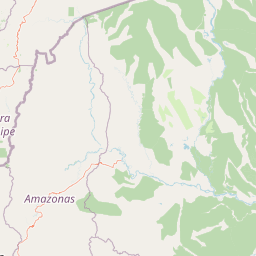
The park's landscape is centered on the Cordillera del Condor, a distinctive forested mountain range characterized by moderate to steep slopes that dominate the terrain. Elevation reaches approximately 2,500 meters at the highest points within the protected area. Between the mountain ridges, the landscape includes lower hills and river terraces, particularly along the valleys of the Cenepa and Santiago rivers. This topographic diversity creates a varied landscape that transitions from lower elevation forest zones through increasingly stunted vegetation as elevation increases, ultimately reaching the dwarf forest communities that characterize the highest ridgelines.
Ichigkat Muja, Cordillera del Condor National Park ecosystems, habitats, and plant life
The park protects part of the Eastern Cordillera Real montane forests ecoregion, one of the biodiverse forest systems of the northern Andes. As elevation increases within the park, the forest structure undergoes a noticeable transformation. At lower elevations, the montane forests support diverse tree species including Alchornea triplinervia, Iriartea deltoidea, and various Inga species. As the terrain rises, these forests transition into cloud forests characterized by greater atmospheric moisture and epiphytic vegetation. At the highest elevations, near the mountain summits, dwarf forest formations develop where trees become increasingly stunted due to environmental conditions. This elevational gradient creates a continuum of habitat types that supports varied ecological communities.
Ichigkat Muja, Cordillera del Condor National Park wildlife and species highlights
The park supports notable populations of bird species including the Andean cock-of-the-rock, a conspicuous bird of the Andean foothills, as well as the oilbird, white-throated toucan, blue-and-yellow macaw, ornate hawk-eagle, and green hermit. Mammalian fauna includes the Venezuelan red howler, jaguar, white-lipped peccary, Amazon dwarf squirrel, southern tamandua, neotropical otter, and nine-banded armadillo. This assemblage of species reflects the park's position at the intersection of Amazonian and Andean ecological zones, where lowland and highland species distributions overlap.
Ichigkat Muja, Cordillera del Condor National Park conservation status and protection priorities
The park was established as an IUCN Category II protected area, recognizing its national park status and primary conservation purpose. It protects a significant portion of the Eastern Cordillera Real montane forests, an ecoregion that faces ongoing pressures from deforestation and habitat fragmentation in the broader region. The protected area serves conservation goals by maintaining forest cover in a mountainous zone that also provides watershed functions for the Cenepa and Santiago river basins. The establishment of the national park created a formal framework for managing this mountain forest ecosystem under Peru's protected areas legislation.
Ichigkat Muja, Cordillera del Condor National Park cultural meaning and human context
The park is located in Condorcanqui Province within the Amazonas Region of Peru, an area with significant indigenous heritage and cultural connections to the surrounding forest landscapes. While the protected area itself focuses on natural preservation, the broader region is home to communities whose traditional land-use practices and relationship with the mountain environments have shaped the cultural landscape over generations.
Top sights and standout views in Ichigkat Muja, Cordillera del Condor National Park
The park offers protection for one of the more accessible montane forest areas in the Cordillera del Condor, with its cloud forest environments representing a distinctive ecosystem type within the Peruvian protected area network. The elevational gradient from approximately 1,500 meters to 2,500 meters creates visual and ecological variety within a single protected area. The presence of both Andean and Amazonian species assemblages makes the park significant for biodiversity conservation in the northern Peruvian highlands.
Best time to visit Ichigkat Muja, Cordillera del Condor National Park
The park experiences a wet tropical climate typical of the northern Peruvian-Ecuadorian border region. Visitors can expect consistent moisture throughout the year, with slightly higher precipitation during the wet season months. The cloud forest environments are particularly characteristic during the wetter periods when atmospheric moisture creates the persistent mist that defines this ecosystem type. Dry season conditions may offer improved access to higher elevation areas, though the mountain environment remains humid year-round.