Why Iriqui National Park stands out
Iriqui National Park is best known for its remarkable ecological transformation during the wet season, when Lake Iriqui becomes a temporary wetland attracting large flocks of migratory waterbirds including flamingos, coots, and geese. The park protects one of the few remaining examples of Saharan acacia woodland and steppe ecosystem in Morocco. It serves as a critical wintering and resting site for birds traversing the East Atlantic flyway. The park also preserves populations of endangered Saharan species including the houbara bustard and North African ostrich, both of which face significant pressure from hunting and habitat loss across their range.
Iriqui National Park history and protected-area timeline
Iriqui National Park was established in 1994 as part of Morocco's expanding network of protected areas. The park's creation was driven by recognition of the ecological significance of the Iriqui area, particularly the importance of Lake Iriqui as a seasonal wetland habitat. At the time of establishment, one of the primary objectives was the rehabilitation and protection of the wetland ecosystem, which had experienced pressure from changing land-use patterns and environmental conditions. The park was placed under the management of the Kingdom of Morocco's High Commission for Water, Forests and Desertification Control, the governmental body responsible for protected area management across the country. The timing of the park's creation reflected a broader trend in Moroccan environmental policy during the 1990s, which saw the designation of several new national parks and protected areas aimed at preserving the kingdom's diverse ecological heritage, from Mediterranean forests to Saharan ecosystems.
Iriqui National Park landscape and geographic character
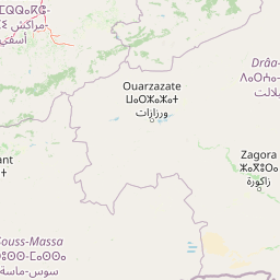
The landscape of Iriqui National Park embodies the classic character of Saharan southern Morocco, characterized by vast expanses of desert terrain punctuated by vegetation where groundwater allows. The terrain includes extensive flat areas of desert plain, sand dune systems that shift with wind patterns, and rocky sections where the underlying geology of the Anti-Atlas region emerges. The Draa River, though often dry or reduced to seasonal flow in its lower reaches, has created a corridor of enhanced vegetation that influences the park's eastern boundary. The most distinctive landscape feature is the basin that becomes Lake Iriqui during wet periods, transforming from a dry depression to a shallow wetland that can cover substantial area. The park's southern boundary approaches the foothills of the Anti-Atlas, introducing slightly more varied topography as the terrain rises toward the mountains. Throughout the park, the contrast between the bare desert surfaces and the green acacia stands creates a visually striking landscape that defines the Saharan aesthetic.
Iriqui National Park ecosystems, habitats, and plant life
The ecological character of Iriqui National Park centers on its representation of Saharan woodland and steppe ecosystems, which have become increasingly rare across North Africa. The park's vegetation is dominated by acacia tortilis, the umbrella thorn tree that forms the characteristic woodland savanna of the Sahara's southern margins. These acacia stands provide critical habitat and resources for numerous species across the dry season. During wet periods, the formation of Lake Iriqui creates a fundamentally different ecological environment, transforming all or part of the basin into a productive wetland that supports aquatic vegetation, invertebrates, and the waterbirds that migrate to exploit this seasonal resource. The temporary nature of the wetland adds to its ecological significance, as species have evolved to capitalize on the brief periods of abundant resources before the landscape returns to arid conditions. The park's position along major bird migration routes amplifies its ecological importance, as the wetland provides essential stopover and wintering habitat for species traveling between European breeding grounds and African wintering areas.
Iriqui National Park wildlife and species highlights
The wildlife of Iriqui National Park reflects the park's position at the intersection of Saharan and Mediterranean ecological realms. The park supports notable populations of Saharan-adapted mammals including barbary sheep, dorcas gazelles, and striped hyenas. The oryx, once widespread across the Sahara, survives in protected populations within the park, representing a conservation success for this iconic desert antelope. Among birds, the park is particularly significant for its populations of houbara bustards, a species that has faced severe pressure from hunting across its range, and North African ostriches, which persist in remnant populations despite habitat loss. The reptile fauna is remarkably diverse for a desert area, with multiple lizard species, horned vipers, monitor lizards, chameleons, geckos, and various snakes recorded within the park. The most seasonally dramatic wildlife occurrence happens when Lake Iriqui fills with water, attracting thousands of migratory waterbirds including flamingos, coots, and geese that use the wetland as a wintering and staging site.
Iriqui National Park conservation status and protection priorities
Iriqui National Park serves as a critical conservation refuge for Saharan biodiversity in Morocco. The park protects one of the most significant remaining examples of Saharan acacia woodland ecosystem, a habitat type that has declined substantially across North Africa due to overgrazing, climate change, and infrastructure development. The seasonal wetland at Lake Iriqui has been a particular focus of conservation attention, with the rehabilitation of the wetland identified as a primary objective at the park's establishment. The park provides essential protection for species of conservation concern, including the houbara bustard, which is hunted throughout its range, and the North African ostrich, whose population has been fragmented by human activity. By protecting this area, Morocco maintains a functional ecosystem that supports both resident Saharan species and the migratory birds that depend on the seasonal wetland. The park's designation as an IUCN Category II protected area reflects its primary mandate of conserving natural landscapes while allowing for sustainable use in designated zones.
Iriqui National Park cultural meaning and human context
The Iriqui region supports a small population of families who have traditionally practiced pastoralism within the area. Thepark's grasslands and acacia woodland provide grazing opportunities that have supported livestock keeping for generations, and this traditional land use forms part of the cultural landscape that the park protects. The Iriqui area represents the main grazing zone within the park boundaries, with the vegetation and seasonal water availability making it suitable for livestock during parts of the year. The human population within the park reflects the broader pattern of low-density settlement characteristic of Morocco's Saharan provinces, where communities have developed sustainable relationships with the challenging desert environment. The region's cultural heritage, including traditional Berber and nomadic practices, contributes to the area's overall significance and forms part of the ecotourism potential that the park's management seeks to develop as a means of supporting local communities.
Top sights and standout views in Iriqui National Park
Iriqui National Park offers visitors the opportunity to experience Saharan wilderness at its most ecologically diverse. The seasonal transformation of Lake Iriqui from dry desert to wetland provides one of the most remarkable wildlife spectacles in Moroccan protected areas, with flocks of pink flamingos creating a vivid contrast against the desert landscape. The park's populations of large Saharan mammals, including barbary sheep, gazelles, and oryx, represent increasingly rare viewing opportunities across the species' ranges. The acacia woodland savanna, with its iconic umbrella-shaped trees, defines the park's visual character and provides shade and structure to the desert ecosystem. Birdwatchers find particular value in the park's position along migration routes, while those interested in desert landscapes appreciate the park's extensive dune systems and the contrast between desert and wetland environments that occurs within a single protected area.
Best time to visit Iriqui National Park
The optimal time to visit Iriqui National Park aligns with the cooler months of late autumn through early spring, roughly November through March, when daytime temperatures are more comfortable for outdoor exploration. The wet season in southern Morocco typically occurs during winter months, and visitors during this period may witness the formation of Lake Iriqui and the arrival of migratory waterbirds, which dramatically transforms the park's character. However, the timing of wetland formation varies from year to year depending on rainfall patterns, so visitors seeking the wetland experience should be prepared for the possibility that conditions may differ from one visit to the next. Summer months bring extreme heat that limits comfortable exploration and increases the challenges of outdoor activity in the desert environment. Those interested in wildlife viewing should note that many species are more active during cooler parts of the day, and the early morning hours often provide the best opportunities for observing mammals and birds.