Why Isla Guamblin National Park stands out
Isla Guamblin National Park is best known for its remarkable marine wildlife, particularly the seasonal presence of blue whales that can be observed from December through April swimming within approximately 100 meters of the coastline. The park also protects a large breeding colony of South American sea lions and serves as a critical nesting site for sooty shearwaters, gulls, cormorants, and ducks. The island's nearly complete coverage with evergreen oceanic forest, featuring species like Nothofagus nitida, Drimys winteri, and Weinmannia trichosperma, represents a well-preserved example of Patagonian coastal vegetation.
Isla Guamblin National Park history and protected-area timeline
The history of Guamblin Island spans several centuries of documented European contact and earlier indigenous presence. The island was first sighted by Europeans during a Spanish expedition in 1557 and 1558, led by Francisco Cortés Ojea aboard the vessel San Sebastián as part of Juan Ladrillero's exploration of the Chilean coast. Cortés Ojea named the island "Nuestra Señora del Socorro" (Our Lady of Help), referencing the Virgin Mary, which remains one of the island's historical designations. Historical accounts suggest the island may have been temporarily inhabited by Chono people, who were hunter-gatherers residing in the island chains of southern Chile, particularly during the 13th or 14th centuries. A significant maritime tragedy occurred in 1725 when the Dutch ship Don Louis, part of an expedition dispatched by the Middelburgsche Commercie Compagnie, anchored at the island after a difficult passage around Cape Horn. Three crew members left ashore to collect provisions were stranded when the ship was driven away by a storm and only their skeletons were found months later when the vessel returned. The island gained unfortunate additional historical significance in June 1973 when the Liberian oil tanker Napier ran aground, spilling approximately 30,000 metric tons of oil. Chilean authorities attempted to burn the oil using Hawker Hunter aircraft to prevent environmental damage to the island's ecosystems.
Isla Guamblin National Park landscape and geographic character
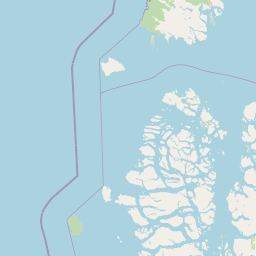
Guamblin Island presents a landscape characterized by its remote Pacific setting, rugged coastline, and forested interior. The island rises to approximately 218 meters above sea level at its highest point, creating a relatively low but distinct topographic presence in the ocean. The terrain features a combination of forested slopes and coastal areas exposed to the full force of Pacific weather systems. The coastline is predominantly rocky and irregular, making approach and landing extremely difficult. The island spans roughly 16 kilometers in a north-south direction with a maximum east-west width of about 8 kilometers. Nearly the entire island surface is covered with vegetation, primarily evergreen oceanic forest and shrubland characteristic of the southern Chilean coast. The landscape maintains a wild, largely untouched character due to the absence of permanent human settlement and the practical difficulties of access.
Isla Guamblin National Park ecosystems, habitats, and plant life
The ecological character of Isla Guamblin National Park is defined by its evergreen oceanic forests and rich coastal marine environments. The island's vegetation belongs to the evergreen oceanic shrub and forest formation typical of Chile's southern Pacific coast. Dominant tree species include Nothofagus nitida (Coigüe de Chiloé), which can reach heights of 25 meters, along with Drimys winteri (Canelo), Weinmannia trichosperma (Tineo), and Tepualia stipularis (Tepú). These species form a dense forest cover across most of the island's interior. The surrounding marine environment supports exceptional biodiversity, particularly in the shallow coastal waters where blue whales congregate seasonally. The island has been recognized as an Important Bird Area, acknowledging its significance for seabird populations.
Isla Guamblin National Park wildlife and species highlights
Isla Guamblin National Park supports remarkable marine and avian wildlife populations. The island serves as a major breeding ground for sooty shearwaters (Ardenna grisea), which nest in substantial colonies on the island. Additionally, various gull species, cormorants, and ducks use the island for nesting and feeding. The coastal waters support one of Chile's most significant populations of South American sea lions, with a large colony using the island as a primary breeding and resting site. Perhaps most notably, blue whales can be observed in the waters surrounding the island from December through April, frequently swimming within approximately 100 meters of the coastline. This seasonal whale presence has attracted scientific attention from researchers worldwide and represents a major draw for visitors who can access the park.
Isla Guamblin National Park conservation status and protection priorities
Isla Guamblin National Park serves as a critical protected area for Chile's southern Pacific coastal ecosystems. The park's designation as a national park and IUCN Category II protected area reflects its ecological significance for preserving both terrestrial and marine biodiversity. The protection of the island's evergreen forests maintains important habitat for endemic plant species while the surrounding waters support marine mammals and seabirds of conservation concern. The island's designation as an Important Bird Area further acknowledges its global significance for seabird conservation. The park's remote location and difficult access have inherently provided a degree of protection from development pressures, though the 1973 oil spill incident demonstrated the vulnerability of island ecosystems to maritime accidents. Management by the Corporación Nacional Forestal focuses on maintaining the integrity of the island's natural systems while providing controlled opportunities for scientific research and environmental education.
Isla Guamblin National Park cultural meaning and human context
While Guamblin Island has never supported permanent human settlement, it holds cultural significance through its historical connections to indigenous groups and European maritime exploration. The Chono people, a now-extinct group of hunter-gatherers who inhabited the islands of southern Chile, may have used Guamblin Island temporarily during the 13th or 14th centuries. The island's European discovery during the mid-16th century Spanish expeditions marks it as part of the broader narrative of Chilean colonial exploration. The name "Nuestra Señora del Socorro" reflects the Catholic context of Spanish maritime nomenclature. The 1725 Dutch maritime expedition and subsequent tragedy adds an international historical dimension to the island's cultural heritage.
Top sights and standout views in Isla Guamblin National Park
The defining highlights of Isla Guamblin National Park include its exceptional marine wildlife viewing opportunities, particularly the seasonal presence of blue whales approaching the coastline between December and April. The island's large sea lion colony represents another major attraction, while breeding populations of sooty shearwaters and other seabirds make it a significant birdwatching destination. The park's extreme remoteness and difficult access create a sense of adventure for those who visit, with the experience of reaching the island itself considered part of its appeal. The nearly complete forest cover of evergreen species including Nothofagus nitida provides a striking green landscape contrasting with the Pacific coastline.
Best time to visit Isla Guamblin National Park
The optimal time to visit Isla Guamblin National Park depends on wildlife viewing objectives. Blue whale sightings are most reliable from December through April, when these massive cetaceans approach the island's coastline and can be observed from land or small vessels. This summer period in the Southern Hemisphere also offers more favorable weather conditions for the already challenging sea crossing to the island. The winter months (May through November) present more difficult access conditions due to increased storm activity and rougher seas around the island. Visitors should note that the island's remote location and limited access options require careful advance planning, regardless of the season chosen.