Why Islas de Santa Fe National Park stands out
Islas de Santa Fe National Park is best known for its unique status as Argentina's sole entirely insular national park and its representation of the Paraná River flood valley ecosystem. The park is celebrated for its extraordinary aquatic biodiversity, particularly its fish fauna including the iconic dorado, as well as the distinctive capybara, the world's largest rodent, which serves as the park's emblem. The park protects significant wetland communities featuring the massive floating leaves of the irupé (Victoria cruziana), one of the world's largest aquatic plants, whose Guaraní name means "water plate." The riparian forests along the albardones (elevated riverbanks) support species like the ceibo, laurel de río, and curupí, creating narrow gallery forests that act as biological corridors through the floodplain.
Islas de Santa Fe National Park history and protected-area timeline
The establishment of Islas de Santa Fe National Park represents a transition from provincial to national protection for a significant wetland area in Santa Fe Province. The territory now within the park was originally designated as the strict nature reserve El Rico in 1968 through Provincial Decree 4070/68. This provincial reserve protected the largest island in the archipelago for over four decades, preserving its ecological values despite limited development pressures in the remote floodplain environment.
The process toward national park status began in 2003 when Provincial Law 12175 established the Provincial System of Protected Natural Areas and declared El Rico as a protected area subject to its framework. A critical legislative step occurred in August 2008 when Provincial Law 12901 authorized the provincial executive power to cede jurisdiction and domain of the islands to the National State for inclusion in the national parks system. Following this authorization, the Province of Santa Fe transferred domain and jurisdiction of the El Rico reserve to the National State through Decree 26/2009 in January 2009.
National Law 26.648, authored by then-senator Rubén Giustiniani, was passed by the National Congress on October 13, 2010, and promulgated by the Executive Power on November 15, 2010. This law accepted the provincial cession of eight island parcels and formally created the National Park "Islas de Santa Fe," bringing the area under the regime of National Law 22.351 governing national parks, natural monuments, and national reserves. The administrative structure was established in 2011 when the National Parks Administration classified the park as a Complexity Level III protected area, placing it under the direction of an appointed superintendent with four departments handling administration, maintenance, national park rangers, and conservation and public use.
Islas de Santa Fe National Park landscape and geographic character
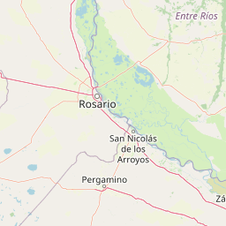
The landscape of Islas de Santa Fe National Park is fundamentally shaped by the hydrological dynamics of the Paraná River, creating a diverse terrain of islands, channels, wetlands, and elevated riverbanks. The islands themselves are products of alluvial deposition, with the constantly shifting river course modifying their shapes and sizes over time. The flood valley in this region is remarkably broad, spanning between 10 and 20 kilometers across, and is filled with alluvial deposits that the river continues to rework through its natural cycle of erosion and deposition.
The topography of the islands features subtle but ecologically significant elevation variations. The lowest areas consist of seasonally inundated marshes andwetlands, while the slightly higher albardones, or natural levees, run along the water channels and support woody vegetation. This microtopography creates a hierarchical system of habitats where plant communities are arranged according to their tolerance of flooding. The permanent water bodies include the main river channels, interconnected lagoons of varying depths, and countless smaller ponds and marshes that dot the landscape. The water bodies range from open river sections with strong current to nearly stagnant lagoons surrounded by dense emergent vegetation.
The visual character of the park is dominated by water in its many forms, with expansive wetlands, winding channels, and still lagoons creating a constantly changing panorama. The emergent vegetation of the wetlands, particularly the tall reed beds and sedge communities, creates vertical elements that punctuate the horizontal expanse of the floodplain. In contrast, the gallery forests along the albardones form narrow but dense ribbons of green that follow the water courses, offering a different textural quality to the landscape. The park lacks significant topographic relief, but the interplay of water and land, flooded and dry ground, creates a dynamic landscape that transforms with seasonal water level fluctuations.
Islas de Santa Fe National Park ecosystems, habitats, and plant life
The ecological character of Islas de Santa Fe National Park is defined by its position within the Paraná River flood valley, creating a complex of wetland habitats that support exceptional biodiversity. The ecoregional context places the park within both the terrestrial ecoregion of the Paraná Delta and Islands and the freshwater ecoregion of the Lower Paraná, a framework that explains the mixing of tropical and subtropical species at the southern limits of their ranges. The climate classification as subtropical pampeano, with no dry month and annual rainfall between 800 and 1,300 millimeters, supports year-round water availability and a long growing season.
The vegetation patterns within the park follow a hierarchical arrangement dictated by flooding tolerance and elevation. The extensive wetland areas are dominated by pajonales, tall grassland communities of emergent grasses and sedges adapted to seasonal inundation. The aquatic communities include diverse associations of floating and submerged plants, with the camalotal and irupé communities representing some of the most distinctive aquatic vegetation in the park. The irupé (Victoria cruziana) produces enormous circular floating leaves that can reach up to two meters in diameter, a remarkable feature that has earned it the Guaraní name meaning "water plate."
The albardones support gallery forests composed of species adapted to periodically flooded conditions. The willow (sauce criollo) and river alder (aliso de río) form early-colonizing stands along newly formed or disturbed riverbanks. In more mature forest stands, the ceibo, river laurel, timbó blanco, and curupí create diverse riparian forests. The transitional influence of the espinal and humid Chaco ecoregions is evident in the presence of species like the espinillo on the lowest elevated sites. This mosaic of wetland, aquatic, and riparian habitats creates the ecological foundation for the park's remarkable diversity of wildlife.
Islas de Santa Fe National Park wildlife and species highlights
Islas de Santa Fe National Park supports an exceptionally rich fauna, reflecting the diversity of aquatic and terrestrial habitats within the Paraná flood valley. The fish community is particularly noteworthy, representing the Lower Paraná freshwater ecoregion with numerous species of ecological and economic importance. The dorado stands out as one of the most prized sport fish, while the surubí common and surubí atigrado represent large catfish species. The sábalo forms enormous schools that migrate through the river system, and the pacú adds another large herbivorous species to the ichthyofauna. The fish community also includes the predatory tararira, various catfish species including bagre sapo and bagre amarillo, the boga, and even the pico-facing freshwater stingrays.
The reptile fauna includes several notable species, with the yacaré negro and yacaré ñato reaching the park from northern regions, where the latter even nests within the islands. Turtles are well represented, including the pond turtle and the long-necked aquatic turtle. The park supports a variety of snakes, with the yarará and ñacaniná among the most recognizable. The amphibian diversity is high, with numerous species of frogs, toads, and escuerzos from multiple families well represented in the wetland environments.
The bird community combines resident and migratory species, with aquatic birds finding ideal habitat in the lagoons and marshes. The park supports populations of the snail kite, a raptor that specializes in feeding on large aquatic snails. The jabiru, commonly known as caraú in the region, is among the most conspicuous wading birds. Waterfowl including various duck species, herons, egrets, and the jacana are abundant. The terrestrial bird community includes species like the hornero, various tyrant flycatchers, woodpeckers, and the distinctive federal, a bird with striking yellow and black plumage. The mammalian fauna includes the capybara, the world's largest rodent, which serves as the park's emblematic species and is commonly observed swimming along the water's edges. The river otter is another characteristic mammal of the waterways, while the marsh deer historically inhabited the area and may be considered for reintroduction.
Islas de Santa Fe National Park conservation status and protection priorities
Islas de Santa Fe National Park plays a significant role in the conservation of Argentina's freshwater and riparian ecosystems. The park protects a representative sample of the Paraná River flood valley, an ecosystem that has faced substantial modification from agricultural expansion, infrastructure development, and water management projects throughout the broader basin. By preserving this island complex, the national park maintains ecological processes and habitats that would otherwise be vulnerable to conversion or degradation.
The park's conservation value is enhanced by its connection to Predelta National Park to the north, creating an extended protected corridor along the Paraná River floodplain. This connectivity supports the movement of migratory species, particularly fish and birds that depend on the river system as a migration corridor. The islands also serve as refuges for wildlife during the extreme flooding events that periodically transform the flood valley, providing higher ground when surrounding areas are submerged.
The wetland habitats protected within the park provide important ecological services, including water filtration, flood regulation, and carbon storage. The diverse plant communities, from floating aquatic vegetation to riparian forests, contribute to the overall health of the Paraná River system. The park also preserves populations of species at the southern limits of their distribution, including several megathermal species whose presence reflects the role of the Paraná flood valley as a biological corridor allowing tropical and subtropical species to extend their ranges southward.
Islas de Santa Fe National Park cultural meaning and human context
The cultural context of the park is intertwined with the history of human settlement along the Paraná River and the specific communities of the islands themselves. The town of Puerto Gaboto, located near the park's administrative headquarters, serves as the primary gateway for visitors and represents the regional identity of the San Jerónimo Department. The region's history includes the historical presence of indigenous Guaraní peoples, as evidenced by the preservation of Guaraní names like irupé in the local flora.
The flood valley has traditionally supported fishing communities and small-scale agricultural use of the islands, activities that shaped the human relationship with this dynamic landscape before the establishment of formal protection. The transfer of the territory from provincial to national jurisdiction reflected a recognition that the unique insular ecosystems required coordinated conservation effort across administrative boundaries. The park's establishment also represents the integration of local ecological knowledge, as evidenced by the use of the capybara as the park's emblem, an animal deeply embedded in the cultural landscape of the Paraná wetlands.
Top sights and standout views in Islas de Santa Fe National Park
Islas de Santa Fe National Park stands as a conservation landmark as Argentina's only entirely insular national park, protecting a unique archipelago within the Paraná River flood valley. The park's exceptional aquatic biodiversity features the iconic dorado and more than 30 fish species in the Paraná inferior freshwater ecoregion. The emblematic capybara, the world's largest rodent, is commonly observed swimming in the waterways, while the distinctive irupé displays remarkable circular floating leaves up to two meters in diameter. The gallery forests along the albardones create narrow green corridors supporting species like the ceibo, river laurel, and curupí. The wetland bird community includes the snail kite, jabiru, jacana, and numerous heron and duck species, while the park also shelters caimans, turtles, and diverse amphibians. The flood valley location creates a dynamic landscape of seasonally flooding islands, permanent waterways, and marshes that support an extraordinary mosaic of ecological communities.
Best time to visit Islas de Santa Fe National Park
The subtropical climate of Isla de Santa Fe National Park offers distinct seasonal characteristics that influence the visitor experience. The warm season extends from October through April, with temperatures ranging from 18 to 32 degrees Celsius and occasional peaks exceeding 40 degrees. This period corresponds with the highest water levels and the most extensive wetland flooding, creating optimal conditions for observing aquatic wildlife and the park's characteristic water-dominated landscape. The summer months of December through February bring the highest precipitation, maintaining the wetland habitats at their fullest extent.
The cooler season from early June through mid-August features average minimum temperatures around 5 degrees Celsius and maximum temperatures near 16 degrees, with occasional frosts possible. This period offers a different character, with lower water levels exposing more of the islands and potentially facilitating access to previously flooded areas. The transition seasons of spring and autumn provide moderate temperatures and can offer balanced conditions for wildlife observation. Visitors should be aware that the park is located in a region prone to severe storms and tornadoes, particularly between October and March, when such weather events are most frequent.