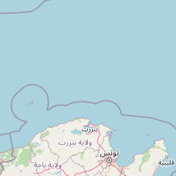
Why Jebel Chitana-Cap Négro National Park stands out
The park is known for its coastal forest landscapes along Tunisia's northern frontier, where Mediterranean woodland covers the hillslopes descending to the sea. The area encompasses the distinctive Jebel Chitana ridge and extends to Cap Négro, a coastal point that gives the reserve part of its name. This stretch of Tunisia's Mediterranean coast features forest ecosystems that are relatively uncommon in the country, comprising species adapted to the cooler, more humid conditions of the north compared to the semi-arid conditions typical of central and southern Tunisia.
Jebel Chitana-Cap Négro National Park history and protected-area timeline
The park was established on July 5, 2010, designated as Tunisia's twelfth national park at the time of its creation. This relatively recent establishment places Jebel Chitana-Cap Négro among the newer additions to Tunisia's protected area network, which began with Ichkeul National Park in the 1980s and expanded through subsequent decades. The creation of the park formalized protection for coastal forest ecosystems that had previously existed under various forest reserve designations. The selection of this coastal area for national park status reflected growing recognition of the ecological value of Tunisia's northern Mediterranean forests and the need to conserve coastal ecosystems that face development pressures from tourism, agriculture, and infrastructure expansion along the Mediterranean rim.
Jebel Chitana-Cap Négro National Park landscape and geographic character
The park's landscape is defined by coastal hillslopes descending through forested terrain toward the Mediterranean Sea. The Jebel Chitana ridge forms the backbone of the protected area, with elevations varying as the terrain approaches the coast. The landscape encompasses forest-covered slopes, rocky coastal sections around Cap Négro, and the transition zones where woodland gives way to agricultural land at the park's inland boundaries. The coastline between Cap Serrat and the Sidi el Barrak Dam features a mixture of rocky shores and vegetated shoreline, with the forest coming close to the sea in several places. This coastal setting contrasts with the more extensive plains and steppe terrain that dominates much of Tunisia's interior.
Jebel Chitana-Cap Négro National Park ecosystems, habitats, and plant life
The park protects Mediterranean forest ecosystems that represent Tunisia's northern ecological character. The vegetation includes species typical of the Mediterranean climate zone, with evergreen and semi-deciduous trees adapted to the relatively mild, wet winters and warm, dry summers of this latitude. The forest composition reflects the influence of higher rainfall in the north compared to the rest of Tunisia, supporting denser and more diverse woodland than is found in southern portions of the country. The coastal setting creates a maritime-influenced environment where salt-tolerant species occupy shoreline zones while more typical woodland occupies the slopes above.
Jebel Chitana-Cap Négro National Park wildlife and species highlights
The Mediterranean forest and coastal terrain of the park provides habitat for wildlife adapted to Tunisia's northern environment. The combination of forest cover, rocky coastline, and proximity to the Mediterranean creates diverse microhabitats supporting various species. While specific species inventories are limited in available sources, the protected coastal forest corridor likely supports bird species associated with Mediterranean woodland and migratory birds that use the coastline as a passage route. The marine zone adjacent to the park contributes to the overall ecological value of the protected area.
Jebel Chitana-Cap Négro National Park conservation status and protection priorities
The establishment of Jebel Chitana-Cap Négro National Park represents Tunisia's effort to maintain ecological connectivity along its Mediterranean coast. The protected area serves as a conservation anchor for northern forest ecosystems that are more limited in extent than the extensive steppe and desert landscapes that dominate central and southern Tunisia. The park's coastal location places it within a region that faces development pressures from tourism infrastructure, agricultural expansion, and coastal development. Formal national park status provides regulatory framework for managing these pressures while preserving the forest ecosystem and its associated biodiversity.
Jebel Chitana-Cap Négro National Park cultural meaning and human context
The park occupies a region of Tunisia with historical significance along the Mediterranean coast. The area lies within the northern coastal zone that has seen centuries of interaction between Tunisian communities and the sea. The forest districts of Bizerte and Béja that encompass the park have traditional connections to forestry, agriculture, and fishing that reflect the broader heritage of Tunisia's northern coast. Place names such as Cap Négro and Jebel Chitana reflect the Arabic linguistic heritage of the region.
Top sights and standout views in Jebel Chitana-Cap Négro National Park
The park's defining feature is its coastal forest setting, where Mediterranean woodland reaches the shoreline along Tunisia's northern coast. The combination of the Jebel Chitana ridge descending to the sea and the rocky promontory of Cap Négro creates a scenic interface between forest and ocean that is distinctive within Tunisia's protected area system. The park's relatively recent establishment and its location between two governorates reflect a coordinated approach to coastal conservation in Tunisia's north.
Best time to visit Jebel Chitana-Cap Négro National Park
The park can be visited year-round, though the Mediterranean climate of northern Tunisia makes spring and autumn particularly pleasant for outdoor exploration. Winter brings cooler temperatures and higher rainfall, which contributes to the forest's vitality but may limit some access. Summer months offer warm conditions suitable for coastal activities, though the interior forest areas provide some refuge from heat. The park's coastal location means that weather patterns are influenced by the Mediterranean, with coastal mists possible in morning hours, particularly during transition seasons.