

Mori Atlas logo
National parkLake Nakuru National Park

Examine the mapped boundaries, alkaline lake hydrology, and varied woodland habitats of this Kenyan protected area.

Lake Nakuru National Park: A Deep Dive into Rift Valley Protected Landscapes and Geography

Lake Nakuru National Park serves as a vital protected area within the Great Rift Valley of Kenya, centered on a shallow alkaline lake that defines the surrounding geological trough. This detailed entry maps the park's terrestrial environment, including its mosaic of acacia woodlands and open grasslands that support diverse ecological systems. By analyzing the hydrological shifts and terrain elevation of this Rift Valley basin, users can better understand the spatial significance and regional geography of this protected landscape.

Rift Valley lakesAlkaline lake ecosystemFlamingo coloniesRhino sanctuaryBirdwatching destinationUNESCO World Heritage Site

Lake Nakuru National Park

National park

Park overview

Structured park overview, official facts, and landscape profile for Lake Nakuru National Park

Lake Nakuru National Park park facts, protected area profile, and essential visitor context

Review the core facts for Lake Nakuru National Park, including designation, size, terrain, visitor scale, habitats, and operating context in one park-focused overview.

About Lake Nakuru National Park

Lake Nakuru National Park represents one of Kenya's most distinctive protected areas, centered on a shallow alkaline lake in the heart of the Great Rift Valley. The park's landscape is defined by the lake itself, a dynamically fluctuating body of water whose surface area has varied dramatically over recent decades due to climate change and catchment changes, temporarily expanding from 40 to 68 square kilometers between 2010 and 2020. The surrounding terrestrial environment features acacia woodlands and euphorbia forests that provide crucial habitat for the park's diverse mammal populations. The park's boundaries were expanded in recent years to create additional sanctuary space for black rhinos, with fencing implemented primarily to deter poaching rather than restrict wildlife movement. A wildlife corridor along the southeastern boundary connecting to the Soysambu Conservancy represents potential future expansion of habitat and maintains connectivity to Lake Naivasha. The park's proximity to Nakuru town creates both accessibility benefits and management challenges related to urban development pressures in the surrounding area.

Quick facts and research context for Lake Nakuru National Park

Lake Nakuru National Park occupies a strategic position in Kenya's Rift Valley near the town of Nakuru, protecting a shallow alkaline lake that varies in surface area from 5 to 45 square kilometers depending on seasonal conditions. The park was formally established in 1961 and encompasses approximately 188 square kilometers of terrestrial and aquatic habitat. It forms part of the Kenya Lake System, a UNESCO World Heritage Site inscribed in 2011, recognizing its outstanding universal value as a Rift Valley lake ecosystem. The park functions as a designated rhino sanctuary, with fenced areas protecting eastern black rhinoceros and southern white rhinoceros populations, along with relocated Rothschild's giraffes. The lake's alkaline waters support a unique tilapia fish species and sustain the massive flamingo populations that are the park's most iconic feature.

Protection and recognition

Documented conservation scopes, Ramsar listings, and UNESCO world heritage entries

Lake Nakuru National Park Protection Status and International Recognition Data

Lake Nakuru National Park maintains a documented mixed protection status supported by formal international designations, including Ramsar wetland recognition and UNESCO world heritage inclusion. Official records assemble these international frameworks alongside management classifications for comprehensive protected area analysis.
Park context

Deeper park guide and search-rich context for Lake Nakuru National Park

Lake Nakuru National Park history, landscape, wildlife, and travel context

Explore Lake Nakuru National Park through its history, landscape character, ecosystems, wildlife, conservation priorities, cultural context, and seasonal travel timing in a structured park guide built for atlas discovery and search intent.

Why Lake Nakuru National Park stands out

Lake Nakuru is best known for its extraordinary flamingo populations, which regularly number in the millions and create one of Africa's most spectacular wildlife displays. The shallow alkaline lake supports dense populations of cyanobacteria that form the primary food source for these iconic birds, and the constantly shifting masses of pink flamingos along the shoreline have become synonymous with the park's identity. The park is also recognized as one of Kenya's most important rhino sanctuaries, with the fenced rhino保护区 supporting significant populations of both eastern black rhinos and southern white rhinos, representing one of the largest concentrations of these endangered species in the country. The panoramic views from Baboon Cliff overlooking the lake and its flamingo-filled waters provide visitors with the park's most memorable vista.

Lake Nakuru National Park history and protected-area timeline

Lake Nakuru National Park was established in 1961 around the alkaline lake of the same name, creating protected status for a wetland system already recognized for its extraordinary bird populations. The park's initial designation focused on conserving the spectacular flamingo colonies that had long drawn scientific and public attention to the lake. Over subsequent decades, the park's mandate expanded to include rhino conservation, with enclosed sanctuaries established to protect both black and white rhinos from poaching pressures that had severely depleted populations across Kenya. The park was incorporated into the Kenya Lake System of the Great Rift Valley, which successfully gained UNESCO World Heritage Site status in 2011, recognizing the outstanding ecological significance of this cluster of Rift Valley lakes. Ramsar Convention designation followed in 1990, establishing international recognition of the wetland's importance. The park has experienced significant challenges from water level fluctuations, with drought conditions in the 1990s causing dramatic drops and subsequent flooding in 2013 that temporarily submerged park infrastructure.

Lake Nakuru National Park landscape and geographic character

The physical landscape of Lake Nakuru National Park is defined by its position in the Great Rift Valley, a dramatic geological trough running through eastern Africa. The central lake is a shallow alkaline basin varying in depth from less than one foot to approximately six feet, with a surface elevation of 1,754 meters above sea level. The surrounding terrain rises to form rocky cliffs, with Baboon Cliff providing the primary elevated viewpoint over the lake and its surrounds. The terrestrial portions of the park feature a mix of woodland habitats dominated by acacia species and euphorbia trees, with open grasslands occurring in areas where wildlife movement has maintained more open conditions. The landscape character shifts between the aquatic environment of the lake and the denser woodland habitats that provide shade and shelter for mammals during the heat of the day. Recent years have seen significant landscape changes as water levels have risen substantially, causing flooding of previously dry areas and submergence of infrastructure including the main park entrance gate.

Lake Nakuru National Park ecosystems, habitats, and plant life

The ecological character of Lake Nakuru centers on its alkaline lake ecosystem, which supports extraordinarily high productivity despite the harsh chemical conditions. The warm alkaline waters promote dense blooms of cyanobacteria, a blue-green algae that forms the primary food source for the lake's famous flamingo populations. Scientists have calculated that flamingos at Nakuru consume approximately 250,000 kilograms of algae per hectare annually. The lake also supports a unique fish species, Alcolapia grahami, a small tilapia that has thrived since its introduction in the early 1960s, despite the tepid and alkaline conditions that would be unsuitable for most fish. The surrounding terrestrial habitats include acacia woodlands and euphorbia forests that provide important shelter and foraging areas for mammals. The park contains more than 400 resident bird species, with thousands of waterbirds including grebes, terns, stilts, avocets, and ducks present throughout the year, joined in winter by migrant waders from Europe.

Lake Nakuru National Park wildlife and species highlights

Lake Nakuru supports remarkable wildlife diversity across both avian and mammalian communities. The lake is home to two flamingo species, the lesser flamingo and the greater flamingo, with populations sometimes exceeding two million birds that feed on the abundant algae. The park also supports large populations of pelicans and cormorants, along with diverse waterbirds including African fish eagles, Goliath herons, hammerkops, pied kingfishers, and Verreaux's eagles. The terrestrial mammal community is centered on the rhino sanctuary, which in 2009 supported more than 25 eastern black rhinos and around 70 southern white rhinos, representing one of the largest concentrations in Kenya. Rothschild's giraffes, relocated from western Kenya beginning in 1977, are commonly seen, along with waterbuck, Cape buffalo, zebra, and eland. Predators include lions, leopards, and increasingly visible hyenas, while large pythons inhabit the dense woodlands and are frequently seen crossing roads or resting in trees.

Lake Nakuru National Park conservation status and protection priorities

Lake Nakuru National Park holds significant conservation importance at both national and international levels. The park's inclusion in the UNESCO World Heritage Site designation of the Kenya Lake System recognizes its outstanding universal value as a representative Rift Valley lake ecosystem. Ramsar Convention status since 1990 acknowledges its importance as a wetland of international significance, particularly for migratory waterbirds. The rhino sanctuary represents a critical component of Kenya's black rhino conservation strategy, with the fenced area providing protection from poaching that has devastated rhino populations across Africa. The park's expansion to create additional rhino habitat demonstrates ongoing commitment to species conservation. However, the park faces significant challenges from climate change, with water level fluctuations affecting the ecological balance that supports flamingo populations, and pollution from surrounding agricultural and urban development threatening water quality. The migration of flamingos to other lakes in recent years due to changing conditions highlights the vulnerability of these ecological relationships.

Lake Nakuru National Park cultural meaning and human context

Lake Nakuru exists within a landscape of human activity centered on the nearby town of Nakuru, one of Kenya's larger urban centers. The park lies at the southern edge of this growing town, creating interface between urban development and protected area management. The surrounding landscape has experienced significant land use change, with watershed conversion to intensive crop production and urbanization reducing soil absorption capacity and affecting hydrological patterns. The lake system has historical significance as part of a larger freshwater lake that existed approximately 10,000 years ago, when Lake Nakuru, Lake Elementaita, and Lake Bogoria formed a single deep water body before climate changes created the current scattered lake system.

Best time to visit Lake Nakuru National Park

Lake Nakuru can be visited throughout the year, though visitor experiences vary with seasonal conditions. The dry seasons from December through March and June through October typically offer easier wildlife viewing as animals congregate around remaining water sources and vegetation is less dense. The wet seasons bring higher water levels and more lush landscapes but may limit some access routes. Flamingo numbers fluctuate significantly with water conditions, as changes in lake depth and algae productivity affect the suitability of the lake as a feeding ground. Visitors seeking the most reliable flamingo viewing should be aware that populations have become more mobile in recent years, sometimes migrating to neighboring lakes like Lake Bogoria when conditions at Nakuru become unfavorable. The period following the 2013 water level increase saw significant habitat changes, and ongoing climate impacts continue to affect the park's seasonal character.
Monthly climate preview

Long term temperature and precipitation records across twelve months

Lake Nakuru National Park Climate Normals and Annual Weather Patterns

Historical climate data for Lake Nakuru National Park reveals consistent monthly temperature ranges and measured precipitation averages from representative terrain coordinates. Reviewing the complete twelve month profile provides deeper insight into long term environmental conditions across the protected area.
Annual mean16 °C
14 °C17 °C
Jan16°
Feb17°
Mar17°
Apr16°
May15°
Jun15°
Jul14°
Aug14°
Sep15°
Oct16°
Nov16°
Dec16°
Warmest month
March

17.3 °C

Coolest month
July

14 °C

Wettest month
April

6.1 mm/day

Driest month
February

1.5 mm/day

Park location guide

Geography guide, regional context, and park location map for Lake Nakuru National Park

Lake Nakuru National Park park geography, regions, and map view in Kenya

Understand where Lake Nakuru National Park sits in Kenya through a broader geographic reading of the surrounding landscape, nearby location context, and its mapped position within the national park landscape.

How Lake Nakuru National Park fits into Kenya

Kenya is a presidential republic in East Africa and the seventh-most populous country on the continent. Its capital is Nairobi, and it borders five countries and the Indian Ocean. The country features significant geographic diversity including Mount Kenya, the Rift Valley, and coastal regions.

Wider geography shaping Lake Nakuru National Park in Kenya

Kenya is located in East Africa, bordering South Sudan to the northwest, Ethiopia to the north, Somalia to the east, Tanzania to the southwest, and Uganda and Lake Victoria to the west. The southeastern border meets the Indian Ocean. The geography includes the Rift Valley highlands with Mount Kenya, coastal plains, and northern arid regions.

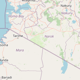
Map view of Lake Nakuru National Park

Use this park location map to pinpoint Lake Nakuru National Park in Kenya, understand its exact geographic position, and read its mapped placement within the surrounding landscape more clearly.

Pigeon | © OpenStreetMap contributors
Recorded earthquake history

Review the Historical Earthquake Catalogue for Lake Nakuru National Park

Explore historical seismic records for Lake Nakuru National Park through a structured, data-driven perspective. This catalogue enables researchers to review event trends and spatial associations, providing clear access to historical magnitude and depth information for the region without speculative interpretation.

Lake Nakuru National Park Earthquake History

Catalogued events

1 event

Strongest magnitude

Magnitude 4.7

Most recent event

Sep 24, 2001

This history includes earthquakes recorded inside the park or within 50 km of its borders

Park atlas

Compare regional geography, connected Rift Valley landscapes, and adjacent protected zones.

Explore Other Parks Near Lake Nakuru National Park and Surrounding Protected Areas

Browse nearby national parks and protected areas sharing the distinctive ecological traits of the surrounding region. Expanding your geographic comparison reveals broader patterns across local terrain and protected landscapes.
National parkRift Valley
Mapped location lies within the park boundary#1 closest

Northeast

Lake Nakuru National Park: Geography and Protected Area Atlas Profile for Rift Valley

Mapped soda lake landscapes and rhino sanctuary boundaries

Lake Nakuru National Park is a prominent protected landscape situated in central Kenya, defined by its shallow alkaline lake and surrounding acacia forests. This profile explores the park's geographic footprint, including its role as a fenced sanctuary for rhinoceros and its location within the volcanic Rift Valley system. The terrain provides a clear study in how tectonic structures and water chemistry shape specialized habitats for large mammals and avian populations.

Area
188 km²
Established
1968
IUCN
II
Relief
Mixed relief
National parkNakuru County
About 53 km away#2 closest

Southeast

Hell's Gate National Park: National Park Atlas and Mapped Landscape Exploration

Discover Nakuru County's protected terrain and geographic context.

Explore the mapped boundaries and unique geographic identity of Hell's Gate National Park, a protected national park within Kenya's Nakuru County. This detailed atlas view focuses on the park's natural landscape and its place within the regional geography, offering structured discovery of its protected terrain and surrounding context. Understand the visual and geographic essence of this significant conservation area.

Area
68.25 km²
Established
1984
IUCN
II
Relief
Mountain
National parkKenya
About 61 km away#3 closest

Southeast

Mount Longonot National Park: Kenya's Mapped Protected Landscape for Atlas Exploration

Discover the natural terrain and park boundaries.

Mount Longonot National Park serves as a vital protected area within Kenya, offering a focused lens for geographical exploration. This national park's defined landscape and mapped boundaries provide essential context for understanding its place in the broader regional geography. Ideal for users seeking detailed information on protected territories, Mount Longonot National Park offers insights into Kenya's natural heritage through an atlas-centric approach.

Scope
Terrestrial
National parkNyeri County
About 64 km away#4 closest

East

Aberdare National Park: Mapped Protected Landscape in Nyeri County

National Park Geography and Atlas Context

Aberdare National Park is a protected national park located within Nyeri County, Kenya. This entry offers detailed geographic information and map context, highlighting its protected boundaries and landscape characteristics. Users can explore its regional setting, understand its specific terrain features, and discover its significance as a conservation area within the Kenyan geography. Access structured data that clarifies the park's identity as a vital protected landscape.

Area
767 km²
Established
1950
IUCN
II
Relief
Mountain
National parkKenya
120 km away#5 closest

Southeast

Nairobi National Park: Detailed Geographic Overview and Protected Landscape Atlas

Explore the mapped boundaries and regional context of this Kenyan national park.

Nairobi National Park represents a significant protected national park entity within Kenya. This MoriAtlas entry provides detailed insight into its geographic placement and mapped landscape characteristics. Users can delve into the park's specific location, its protected boundaries, and its contribution to the regional geography of East Africa, facilitating structured map-based exploration and understanding of this vital conservation area.

Area
117 km²
Established
1946
IUCN
II
Relief
Mixed relief
National parkKenya
About 135 km away#6 closest

East

Mount Kenya National Park: Mapped Volcanic Landscape & Protected Area Geography

Kenya's high-altitude Afro-alpine ecosystems and mapped park boundaries.

Mount Kenya National Park safeguards a globally significant volcanic landscape and vital water resources for Kenya. This protected area above 3,000 meters features dramatic peaks, glaciers, and distinctive Afro-alpine flora. Explore its comprehensive mapped boundaries, understand its regional geographic importance, and discover the unique ecosystems that define this exceptional national park through detailed atlas context.

Area
715 km²
Established
1949
IUCN
II
Relief
Mountain
National parkKenya
About 141 km away#7 closest

Southeast

Ol Donyo Sabuk National Park: Kenya's Prominent Highland Volcanic Protected Landscape

Mapped National Park boundaries and montane forest geography.

Ol Donyo Sabuk National Park represents a vital protected natural area situated in Kenya's central highlands. Its landscape is dominated by a striking volcanic peak, offering a unique montane forest environment and significant primate habitat. This entry provides essential details for atlas exploration, focusing on the park's geographic placement, its protected landscape features, and the ecological context it represents within Kenya's protected areas system.

IUCN
II
Relief
Mountain
Scope
Terrestrial
Water
Minor water
National parkMara Region
161 km away#8 closest

Southwest

Serengeti National Park: National Park Atlas and Protected Landscape Discovery

Explore savanna grasslands, regional geography, and mapped park boundaries.

Serengeti National Park, a significant national park within Tanzania's Mara Region, offers an unparalleled view into a vast protected landscape. This page provides access to the park's geographic identity, its defining savanna ecosystem, and its role as a critical component of the regional atlas. Understand the mapped extent of its protected boundaries and the unique natural context that supports its renowned wildlife.

Area
14,763 km²
Established
1940
IUCN
II
Visitors
350K annual

Common questions about visiting, size, designation, and location context for Lake Nakuru National Park

Lake Nakuru National Park FAQs for park facts, access, geography, and protected area context

Find quick answers about Lake Nakuru National Park, including protected-area facts, park geography, trail and visitor context, and how the park fits into its surrounding country and regional landscape.
MoriAtlas Explorer

Continue Your Protected Areas Search Across the Global Atlas

Deepen your exploration by continuing the structured search for national parks and protected areas worldwide. Utilize the comprehensive filtering capabilities to compare different conservation landscapes and refine your understanding of global park geography. Discover more about the distribution and characteristics of protected natural areas.

Global natural geography
