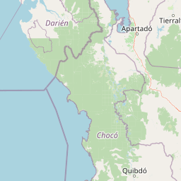
Why Los Katíos National Natural Park stands out
Los Katíos is internationally recognized for its exceptional biodiversity concentration, hosting at least 450 bird species representing more than 25% of Colombia's total avian diversity within less than 1% of the country's land area. The park serves as the only place in South America where many Central American species thrive, including the Giant Anteater and Central American tapir, reflecting its unique position as a biogeographic filter between continents. The park protects critical habitat for nearly 20% endemic plant species specific to the Chocó-Darién moist forests, one of the world's most threatened ecoregions. Notable landscape features include the 25-meter-high Tendal waterfall, the 100-meter-high Tilupo waterfall, and the extensive Tumaradó swamps.
Los Katíos National Natural Park history and protected-area timeline
The region now protected as Los Katíos has a rich human history extending back thousands of years. The area was originally inhabited by the Guna people, an indigenous group who maintained territorial control over the Chocó region until internal conflicts forced them to surrender the land to the Katío-Embera peoples and migrate eastward to Panama. The Darién region, encompassing the park, holds particular significance as part of the ancient land bridge that enabled human migration from North to South America approximately 20,000 years ago during the Pleistocene epoch. Following European contact, the region was first explored by Spanish conquistadors including Rodrigo de Bastidas, Alonso de Ojeda, and Vasco Núñez de Balboa in 1501. In more recent centuries, portions of the park area, particularly the Sautatá region, were developed for agricultural purposes, primarily sugarcane cultivation. Following the formal establishment of the park in 1974, the Colombian government undertook efforts to relocate approximately 150 local families from within the protected area to neighboring towns including Unguía, Puente América, Tumaradó, and Cacarica over the subsequent seven years. By 1990, the park had developed sufficient infrastructure, including marked trails and accommodations for small visitor groups, to allow controlled access through the park administration in Sautatá. The park faced significant conservation challenges in the 2000s, leading to its placement on the UNESCO World Heritage in Danger list in 2009 at the Colombian government's request, citing threats from deforestation, illegal settlements, unauthorized fishing, and poaching. Successful management interventions and enhanced enforcement efforts enabled the park's removal from the danger list in 2015.
Los Katíos National Natural Park landscape and geographic character
The topography of Los Katíos National Natural Park exhibits remarkable diversity across its 720 square kilometer extent. The park's western portion is dominated by the Serranía del Darién, a mountainous ridge system that forms part of the northern extension of the Andes mountain range. These hills include lower formations reaching approximately 250 meters in elevation alongside higher peaks attaining roughly 600 meters. The eastern portion of the park consists of the extensive Atrato River floodplains, a flat lowland zone characterized by exceptionally fertile alluvial soils deposited by one of Colombia's most significant river systems. The floodplain contains two distinct terrace types: lower-lying terraces that experience frequent seasonal flooding, and higher terraces that remain mostly dry. Swampy marshes and wetlands dominate the landscape, spreading across nearly half of the park's total area and representing one of the most extensive wetland systems in the region. The park also contains several notable waterfall features, including the 25-meter-high Tendal waterfall and the 100-meter-high Tilupo waterfall, as well as the significant Tumaradó swamp complex. The catival forest formation, characterized by dense stands of the emergent cativo tree, creates a distinctive landscape feature found nowhere else in the world except portions of Central America and Jamaica.
Los Katíos National Natural Park ecosystems, habitats, and plant life
Los Katíos National Natural Park protects one of the most biologically diverse ecosystems in the Americas. The park lies within the Chocó-Darién moist forests ecoregion, one of the most species-rich and yet critically threatened forest complexes on Earth. The park's position on the southern edge of the Central American land bridge has created unique conditions for biogeographic exchange between North and South American fauna and flora, resulting in a混合 of species from both continents that occurs nowhere else in South America. Nearly 20% of the plant species found within the park are endemic to the Chocó-Darién moist forests, meaning they exist nowhere else on the planet. The catival forest ecosystem represents a particularly distinctive habitat, characterized by the dominance of the cativo tree, a species that can reach heights of 50 meters and forms extensive monospecific stands in the wetland areas. This unique forest formation occurs only in Colombia, southern Central America, and Jamaica. The park's wetlands and floodplain ecosystems support specialized vegetation adapted to periodic inundation, creating critical habitat for numerous species dependent on aquatic and riparian environments.
Los Katíos National Natural Park wildlife and species highlights
Los Katíos National Natural Park supports an extraordinary concentration of wildlife, with particular significance for bird species. The park hosts at least 450 bird species, representing more than 25% of Colombia's total avian diversity concentrated in less than 1% of the country's territory. This exceptional bird density places Los Katíos among the most important bird conservation areas in the Neotropics. The park serves as a critical refuge for numerous mammal species, including the iconic Giant Anteater, which reaches its southernmost confirmed population extent within the park's boundaries. Similarly, the Central American tapir, a large browsing mammal typically associated with Central American forests, maintains populations in Los Katíos as the only significant presence in South America. The park's position as a biogeographic filter has resulted in the presence of numerous Central American species that occur nowhere else in South America, including certain yew species. The wetlands and floodplains support specialized aquatic fauna and provide critical habitat for species dependent on riparian and wetland environments. The combination of montane forest, lowland forest, and extensive wetland habitats creates the ecological diversity necessary to support this remarkable vertebrate assemblage.
Los Katíos National Natural Park conservation status and protection priorities
Los Katíos National Natural Park represents a cornerstone of conservation efforts in northwestern Colombia and the broader Darién Gap region. The park's designation as a UNESCO World Heritage Site in 1994 recognized its outstanding universal value as one of the most biodiverse regions on Earth, protecting critical habitat within the Chocó-Darién moist forests, one of the world's biodiversity hotspots. The park's transboundary connection with Darién National Park in Panama creates the only continuous protected corridor spanning the Colombia-Panama border, enabling wildlife movement and ecological processes that would otherwise be fragmented by human development. The park faced significant conservation challenges during the 2000s that prompted its placement on the UNESCO List of World Heritage in Danger in 2009, including deforestation from agricultural expansion, unauthorized settlements within park boundaries, illegal timber extraction, and unsustainable fishing and hunting practices. The Colombian government responded with enhanced management strategies and enforcement measures that successfully addressed these threats, leading to the park's removal from the danger list in 2015. The park protects important ecosystem services for local communities, including watershed protection and flood regulation from the Atrato River system, while also preserving genetic resources of global significance.
Los Katíos National Natural Park cultural meaning and human context
The region now within Los Katíos National Natural Park holds deep cultural significance for indigenous peoples. The area was historically inhabited by the Guna people, an indigenous group who maintained territorial presence in the Chocó region until conflicts with the Katío-Embera peoples forced their migration to Panama. The Darién region, encompassing the park, played a crucial role in human history as part of the ancient land bridge that facilitated the movement of human populations from North to South America during the Pleistocene epoch, some 20,000 years ago. Following European contact, the region became part of the Spanish colonial territory and was first documented by explorers including Rodrigo de Bastidas, Alonso de Ojeda, and Vasco Núñez de Balboa in 1501. The park's establishment in 1974 necessitated the relocation of approximately 150 families who had been practicing agriculture, primarily sugarcane cultivation, in the Sautatá area. These families were relocated to neighboring communities including Unguía, Puente América, Tumaradó, and Cacarica, reflecting the ongoing challenge of balancing conservation objectives with the rights and livelihoods of local communities.
Top sights and standout views in Los Katíos National Natural Park
Los Katíos National Natural Park stands as one of the most biodiversity-rich protected areas in the Americas, with 450+ bird species and nearly 20% endemic plant species in a landscape spanning 720 square kilometers of tropical forest, wetlands, and mountains. The park's unique position on the Central American land bridge enables the presence of Central American species like the Giant Anteater and tapir that occur nowhere else in South America. Notable landscape features include the 100-meter Tilupo and 25-meter Tendal waterfalls, plus the extensive Tumaradó swamps and distinctive catival forest ecosystem. The park achieved UNESCO World Heritage status in 1994 and successfully overcame a period on the World Heritage in Danger list from 2009 to 2015 through improved management. The contiguous protected corridor with Panama's Darién National Park creates the only continuous transboundary forest protection in the region.
Best time to visit Los Katíos National Natural Park
Los Katíos National Natural Park can be visited year-round given its location in a tropical wet climate, though the period from December through April generally offers drier conditions and more comfortable exploration of trail systems. The wet season from May to November brings higher rainfall, which can limit access to certain areas and create challenging conditions for wildlife viewing, though the forest remains accessible. The park's accessibility has been improved since 1990 when visitor infrastructure including trails and basic accommodations were developed, allowing small groups to access the protected area through the park administration in Sautatá. The dry season months typically provide better opportunities for observing wildlife concentrated around remaining water sources, while the wet season showcases the floodplains and waterfalls at their most impressive. Visitors should be prepared for humid conditions regardless of season and should coordinate with park authorities in advance due to the limited infrastructure and controlled access policies.