


Mori Atlas logo
Nature reserveMaire de Castroponce

A detailed look at the regional geography and natural terrain features defining this protected area.

Maire de Castroponce Nature Reserve: Analyzing Geographic Boundaries and Protected Landscape Context in Spain

(Landschaftsschutzgebiet Oberes Würmtal nördlich Hildrizhausen samt dem Talbecken um Mauren zwischen Holzgerlingen und Ehningen)

Maire de Castroponce represents a significant protected area within the Spanish landscape, serving as a key site for understanding regional geography and conservation patterns. This data-driven profile examines the spatial extent and environmental context of the reserve, allowing for a clearer interpretation of its role in the broader atlas of natural lands. Explore the specific topographical features and mapped boundaries that characterize this unique natural site within its local Spanish setting.

landscape protection areameadow valleyWürm riverGlemsbachMaurener SeeSchönbuch
An illustration showing a winding river leading to a waterfall surrounded by cliffs, trees, and a foreground of wildflowers under a pale sky with a sun.

Maire de Castroponce

Nature reserve

Park overview

Structured park overview, official facts, and landscape profile for Oberes Würmtal nördlich Hildrizhausen samt dem Talbecken um Mauren zwischen Holzgerlingen und Ehningen

Oberes Würmtal nördlich Hildrizhausen samt dem Talbecken um Mauren zwischen Holzgerlingen und Ehningen park facts, protected area profile, and essential visitor context

Review the core facts for Oberes Würmtal nördlich Hildrizhausen samt dem Talbecken um Mauren zwischen Holzgerlingen und Ehningen, including designation, size, terrain, visitor scale, habitats, and operating context in one park-focused overview.

About Oberes Würmtal nördlich Hildrizhausen samt dem Talbecken um Mauren zwischen Holzgerlingen und Ehningen

Oberes Würmtal nördlich Hildrizhausen samt dem Talbecken um Mauren zwischen Holzgerlingen und Ehningen is a landscape protection area (Landschaftsschutzgebiet) located in the Böblingen district of Baden-Württemberg in southwestern Germany. It forms one element of a broader network of protected landscapes maintained by the district administration, sitting between the communities of Altdorf, Ehningen, and Holzgerlingen just east of the town of Holzgerlingen.

The protected area covers approximately 195.5 hectares and is classified internationally as an IUCN Category V Protected Landscape/Seascape. It lies within the natural regions of Schönbuch und Glemswald to the north and Obere Gäue to the south, two characteristic landscape zones of the greater Stuttgart region. These natural regions are known for their combination of densely forested uplands and open, traditionally used valley floors; the landscape protection area preserves the valley component of this combination.

At its core, the protected area preserves a wide-reaching meadow valley landscape shaped by the Würm river (here in its upper course before it eventually reaches the Nagold system) and by the Glemsbach, which joins the river within the area. The Talbecken around Mauren, the basin that gives the protected area part of its name, forms a gently opening landscape hollow east of Holzgerlingen. Within this setting lies the Maurener See, a lake-like waterbody that has been additionally protected as a Naturdenkmal, a small-scale natural monument status under German conservation law.

The protected area reflects a regional tradition of designation through Sammelverordnungen, or collective ordinances, in which multiple landscapes were protected simultaneously within a single administrative act. The 10 October 1974 ordinance that established this area also superseded an earlier 30 December 1959 ordinance covering landscape protection across the district. The result is a compact, legally established protected area whose purpose remains fundamentally tied to preserving an identifiable regional landscape character.

Quick facts and research context for Oberes Würmtal nördlich Hildrizhausen samt dem Talbecken um Mauren zwischen Holzgerlingen und Ehningen

This is a landscape protection area (Landschaftsschutzgebiet) with the official designation number 1.15.066, managed by the Böblingen district administration. It is classified as an IUCN Category V Protected Landscape/Seascape and carries the World Database on Protected Areas identifier 324245.

The protected area spans approximately 195.5 hectares and lies east of Holzgerlingen, straddling parts of Altdorf, Ehningen, and Holzgerlingen municipalities. Its central features are the meadow valley of the Würm river and the related basin around Mauren, including the Maurener See natural monument. It belongs to the Schönbuch und Glemswald and Obere Gäue natural regions of southwestern Germany.

Protection and recognition

Examine documented protected area records and official designation data.

Maire de Castroponce Protection Status and International Recognition

Maire de Castroponce holds structured conservation records detailing verified protection status and administrative boundaries. Official database entries compile international recognition history alongside foundational protected area attributes.

Protection details

WDPA ID
324245
Park context

Deeper park guide and search-rich context for Oberes Würmtal nördlich Hildrizhausen samt dem Talbecken um Mauren zwischen Holzgerlingen und Ehningen

Oberes Würmtal nördlich Hildrizhausen samt dem Talbecken um Mauren zwischen Holzgerlingen und Ehningen history, landscape, wildlife, and travel context

Explore Oberes Würmtal nördlich Hildrizhausen samt dem Talbecken um Mauren zwischen Holzgerlingen und Ehningen through its history, landscape character, ecosystems, wildlife, conservation priorities, cultural context, and seasonal travel timing in a structured park guide built for atlas discovery and search intent.

Why Oberes Würmtal nördlich Hildrizhausen samt dem Talbecken um Mauren zwischen Holzgerlingen und Ehningen stands out

The protected area is best known for preserving an expansive, open meadow valley landscape along the upper course of the Würm river and the basin around Mauren. The valley's mosaic of grasslands, stream corridors, and gentle basin topography gives the protected area its characteristic identity. A key focal point is the Maurener See, a designated natural monument situated within the protection area. Together with the surrounding meadows of the Würm and Glemsbach, this lake-like waterbody anchors the landscape's visual and ecological character.
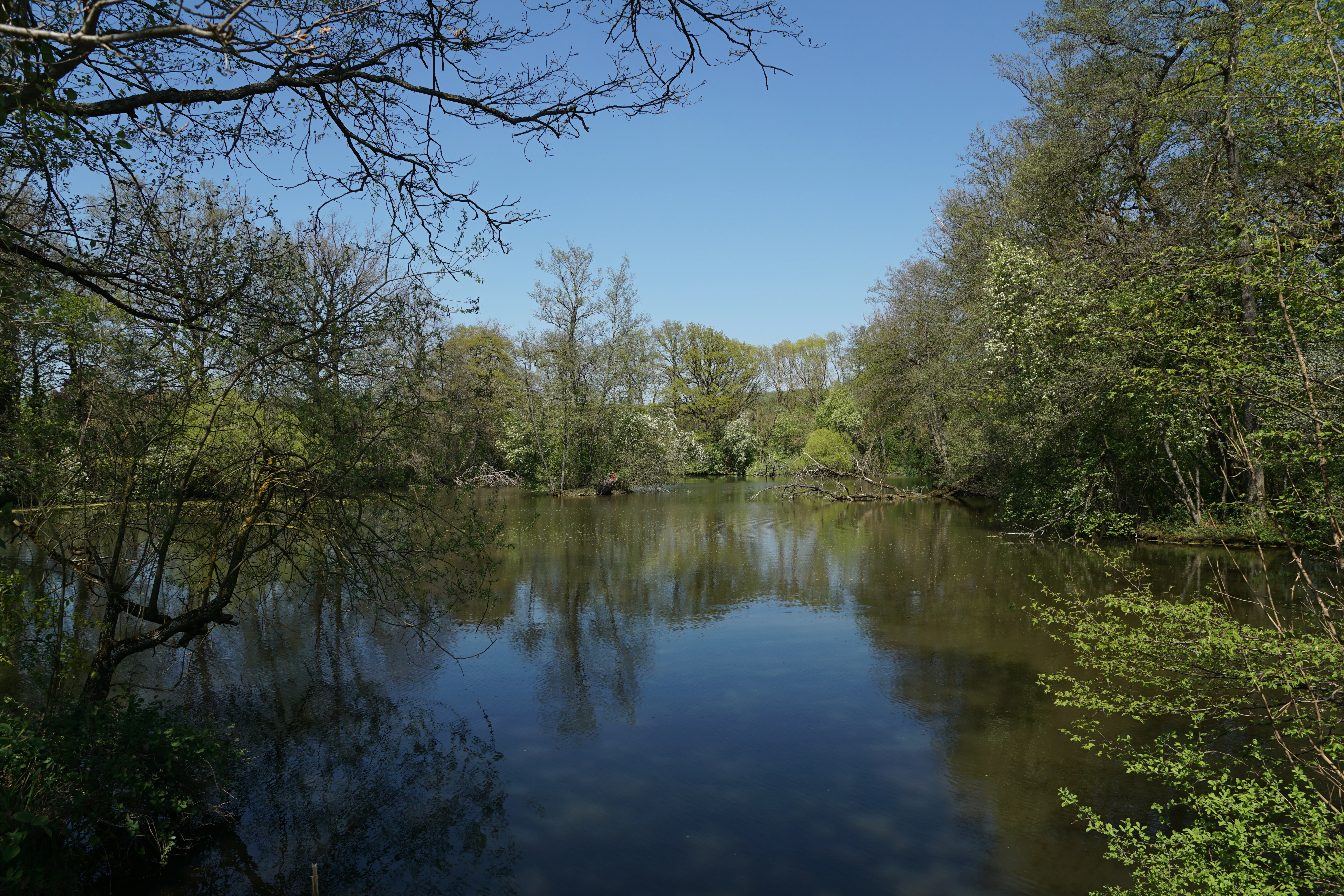
A calm, still lake surface surrounded by lush green trees and shrubs on a clear day.
A serene lake view framed by dense woodland, reflecting the clear blue sky.

Oberes Würmtal nördlich Hildrizhausen samt dem Talbecken um Mauren zwischen Holzgerlingen und Ehningen history and protected-area timeline

The protected area was formally designated on 10 October 1974 by ordinance of the Lower Nature Conservation Authority at the Böblingen district office (Untere Naturschutzbehörde beim Landratsamt Böblingen). The ordinance assigned it the official landscape protection area number 1.15.066.

Its creation was part of a Sammelverordnung, a collective ordinance that bundled several separate protected landscape designations into a single administrative act. The new ordinance replaced the earlier 30 December 1959 regulation that had governed landscape protection across the district's communal territory. The result was a more clearly defined and individually numbered set of protected landscape areas, of which this was one.

Since its establishment, the area has remained under the administration of the Böblingen district. It was registered in the World Database on Protected Areas under identifier 324245 and classified as an IUCN Category V Protected Landscape/Seascape. Its designation status has not been altered since 1974, and it continues to function as a landscape-level conservation instrument rather than a strict nature reserve.

Oberes Würmtal nördlich Hildrizhausen samt dem Talbecken um Mauren zwischen Holzgerlingen und Ehningen landscape and geographic character

The protected area's landscape is defined by the upper course of the Würm river and by the Glemsbach stream, whose valley they jointly shape. The result is a broad, open meadow valley, a Wiesentallandschaft, that contrasts sharply with the more wooded surroundings of the Schönbuch forest to the north and the uplands of the Obere Gäue to the south.

Topographically, the landscape consists of gently sloping valley sides descending toward the stream and a distinct basin feature (Talbecken) around Mauren. This basin opens the valley out into a more level meadow landscape, which gives the protected area its sense of spaciousness. To the east of Holzgerlingen, where the protected area is located, the valley sits within a transitional zone between forested uplands and agricultural lowlands.

The most notable single landscape element is the Maurener See, a lake-like waterbody lying within the protection area and additionally designated as a Naturdenkmal. Around it, the valley transitions between wetland-adjacent meadows, gently sloping forest edges, and the broader agricultural landscape that characterizes the Böblingen district.

Oberes Würmtal nördlich Hildrizhausen samt dem Talbecken um Mauren zwischen Holzgerlingen und Ehningen ecosystems, habitats, and plant life

Ecologically, the protected area is built around the open meadow habitats of the Würm and Glemsbach valleys, with the Maurener See providing a wetland anchor. The meadow valley system supports a grassland-dominated habitat mosaic unusual in a region more commonly identified with its forests, including large parts of the adjacent Schönbuch.

The valley's ecological value lies in its openness. Because traditional meadow use has been maintained over a long period, the valley functions as an open habitat corridor between more densely forested areas. The Maurener See adds static water habitat to the system, while the surrounding stream networks of the Würm and Glemsbach contribute riparian and floodplain habitat elements.

The protected area belongs to two recognized natural regions: Schönbuch und Glemswald, a large forested block to the north, and Obere Gäue, a more open upland and valley complex to the south. Its placement within both regions underlines its transitional ecological role, bridging forested upland ecosystems and traditionally grazed lowland valley landscapes.

Oberes Würmtal nördlich Hildrizhausen samt dem Talbecken um Mauren zwischen Holzgerlingen und Ehningen wildlife and species highlights

The protected area's wildlife profile is shaped by its combination of open meadow valley habitat, riparian corridors along the Würm and Glemsbach, and the still-water habitat of the Maurener See. This mosaic supports the kinds of species associated with traditional grassland valleys, including meadow-breeding birds, wetland-associated fauna attracted to the lake, and stream-dependent wildlife along the two named watercourses.

The Maurener See, as a designated Naturdenkmal, carries additional importance for aquatic and semi-aquatic wildlife within the broader landscape. Open wetland and water-edge habitats, while modest in scale, are ecologically significant in a region where such features are relatively scarce due to extensive forest cover and agricultural drainage elsewhere.

Because the protected area sits at the edge of the Schönbuch forest, it also functions as an ecological interface for forest-edge and open-land species that use both habitats over the course of a year.

Oberes Würmtal nördlich Hildrizhausen samt dem Talbecken um Mauren zwischen Holzgerlingen und Ehningen conservation status and protection priorities

The protected area is classified under German law as a Landschaftsschutzgebiet (landscape protection area), a designation focused on preserving the character of an identifiable regional landscape rather than narrowly protecting individual species. Nationally, this category stresses the preservation of traditional land use, scenic value, and recreational suitability, rather than strict ecological isolation.

Internationally, the protected area is registered in the World Database on Protected Areas (WDPA ID 324245) as an IUCN Category V Protected Landscape/Seascape. This category specifically recognizes areas where human interaction with nature has produced valuable landscapes worth protecting, including working agricultural and meadow landscapes such as this one.

The stated Schutzzweck, or protection purpose, centers on three elements: preserving the characteristic meadow valley landscape of the Würm, securing the area for recreational use, and protecting it from further settlement and fragmentation. Together, these purposes reflect a conservation approach that balances ecological preservation, landscape continuity, and public recreation in a peri-urban setting.

Oberes Würmtal nördlich Hildrizhausen samt dem Talbecken um Mauren zwischen Holzgerlingen und Ehningen cultural meaning and human context

The landscape protected here reflects centuries of traditional meadow and pasture use in the valleys between the Schönbuch forest and the farming uplands of the Obere Gäue. Such meadow valleys are a long-standing cultural element of southwestern German rural landscapes, and their preservation under landscape protection status reflects an effort to maintain that cultural continuity in the face of suburban pressure around Stuttgart.

The naming of the protected area itself is telling: it refers not just to the Würm valley but specifically to the Talbecken, or valley basin, around Mauren, a small locality east of Holzgerlingen. Inclusion of this basin in the formal title underscores the local cultural-geographic significance of the basin feature as a distinct element of the regional landscape.

Top sights and standout views in Oberes Würmtal nördlich Hildrizhausen samt dem Talbecken um Mauren zwischen Holzgerlingen und Ehningen

The protected area's most distinguishing feature is its wide, open meadow valley, an unusual sight in a region dominated by forest. The presence of the Maurener See as a separately protected natural monument within the landscape protection area layers additional ecological importance onto an already distinctive valley setting.

Its position as a Sammelverordnung-protected area, established collectively with other landscapes in 1974 but retaining its own designation number, gives the protected area both administrative identity and a clear connection to the broader conservation history of the Böblingen district. Its IUCN Category V status also places it firmly within the international family of protected landscapes where traditional land use and conservation coexist.

Best time to visit Oberes Würmtal nördlich Hildrizhausen samt dem Talbecken um Mauren zwischen Holzgerlingen und Ehningen

As a working meadow valley landscape, the protected area expresses its character most fully when the grasslands are in active growth and the valley is open and green. Late spring through early autumn generally offers the broadest visual expression of the Würm valley's meadow character, when flowering meadow plants, active agricultural use, and the openness of the basin around Mauren are most visible.

Late spring and early summer also tend to be favorable for observing the wetland-associated wildlife around the Maurener See, while the more open landscape makes any season reasonably accessible for low-impact walking and quiet recreation along the valley. Winter visits offer a different but equally valid perspective, with the bare valley structure and basin form of the Talbecken around Mauren clearly visible without foliage cover.

Park location guide

Geography guide, regional context, and park location map for Oberes Würmtal nördlich Hildrizhausen samt dem Talbecken um Mauren zwischen Holzgerlingen und Ehningen

Oberes Würmtal nördlich Hildrizhausen samt dem Talbecken um Mauren zwischen Holzgerlingen und Ehningen park geography, regions, and map view in Spain

Understand where Oberes Würmtal nördlich Hildrizhausen samt dem Talbecken um Mauren zwischen Holzgerlingen und Ehningen sits in Spain through a broader geographic reading of the surrounding landscape, nearby location context, and its mapped position within the national park landscape.

How Oberes Würmtal nördlich Hildrizhausen samt dem Talbecken um Mauren zwischen Holzgerlingen und Ehningen fits into Spain

Spain, officially the Kingdom of Spain, is a unitary parliamentary constitutional monarchy located in Southern and Western Europe. The country occupies most of the Iberian Peninsula and includes territories in the Mediterranean and Atlantic. With a population of approximately 49.6 million and an area of 506,030 km², Spain is a major European economy and cultural force. Its capital is Madrid, and the country is known for its diverse landscapes ranging from mountainous regions to coastal areas.

Wider geography shaping Oberes Würmtal nördlich Hildrizhausen samt dem Talbecken um Mauren zwischen Holzgerlingen und Ehningen in Spain

Spain occupies the Iberian Peninsula in Southern and Western Europe. Peninsular Spain is bordered to the north by France, Andorra, and the Bay of Biscay; to the east and south by the Mediterranean Sea and Gibraltar; and to the west by Portugal and the Atlantic Ocean. The territory includes the Canary Islands in the Atlantic Ocean, the Balearic Islands in the Mediterranean Sea, and the autonomous cities of Ceuta and Melilla in mainland Africa. Spain features diverse terrain including the Pyrenees in the northeast, the Sierra Nevada in the south, and the Meseta Central plateau.

Visual reference exploring terrain, valley habitats, and natural features

Maire de Castroponce Photos, Scenery, and Protected Area Landscapes

Visual documentation captures the defining terrain, vegetation patterns, and open spaces that shape the protected park environment. Examining field photography helps reveal the distinct ecological character and regional landscape features of Maire de Castroponce.

A calm, still lake surface surrounded by lush green trees and shrubs on a clear day.

A field filled with yellow sunflowers and pink cosmos flowers in the foreground, with an open golden field and distant trees under a cloudy sky in the background.

Common questions about visiting, size, designation, and location context for Oberes Würmtal nördlich Hildrizhausen samt dem Talbecken um Mauren zwischen Holzgerlingen und Ehningen

Oberes Würmtal nördlich Hildrizhausen samt dem Talbecken um Mauren zwischen Holzgerlingen und Ehningen FAQs for park facts, access, geography, and protected area context

Find quick answers about Oberes Würmtal nördlich Hildrizhausen samt dem Talbecken um Mauren zwischen Holzgerlingen und Ehningen, including protected-area facts, park geography, trail and visitor context, and how the park fits into its surrounding country and regional landscape.
MoriAtlas Explorer

Continue Your Protected Areas Search Across the Global Atlas

Deepen your exploration by continuing the structured search for national parks and protected areas worldwide. Utilize the comprehensive filtering capabilities to compare different conservation landscapes and refine your understanding of global park geography. Discover more about the distribution and characteristics of protected natural areas.

Global natural geography